Blackbutt Creek Flood Study Community Bulletin - Ku-ring-gai Council
Blackbutt Creek Flood Study Community Bulletin - Ku-ring-gai Council
Blackbutt Creek Flood Study Community Bulletin - Ku-ring-gai Council

Create successful ePaper yourself
Turn your PDF publications into a flip-book with our unique Google optimized e-Paper software.
<strong>Blackbutt</strong> <strong>Creek</strong> <strong>Flood</strong> <strong>Study</strong> <strong>Community</strong> <strong>Bulletin</strong><br />
18 June 2013<br />
This <strong>Community</strong> <strong>Bulletin</strong> has been issued to inform the residents of <strong>Ku</strong>-<strong>ring</strong>-<strong>gai</strong> of the<br />
<strong>Flood</strong> <strong>Study</strong> being prepared for the <strong>Blackbutt</strong> <strong>Creek</strong> Catchment. It is the first of a series of<br />
<strong>Bulletin</strong>s planned to inform residents. <strong>Ku</strong>-<strong>ring</strong>-<strong>gai</strong> <strong>Council</strong> has engaged consultants SKM<br />
to undertake the <strong>Flood</strong> <strong>Study</strong>.<br />
The purpose of the study is to develop an understanding of existing flooding behaviour in<br />
the catchment. This will enable potential flooding trouble spots to be identified for future<br />
assessment of management strategies to reduce the impact of flooding on the<br />
community, and assist in managing future development of the area.<br />
An integral part of the study process is community consultation and involvement. This<br />
element of the process aims to inform the community of the study and invite residents to<br />
provide information on their views and experiences with flooding in the area. The<br />
management of flood prone land is primarily the responsibility of <strong>Council</strong>s and follows a<br />
number of stages.<br />
Data Collection<br />
<strong>Flood</strong> <strong>Study</strong><br />
<strong>Flood</strong>plain Risk<br />
Management<br />
<strong>Study</strong><br />
<strong>Flood</strong>plain Risk<br />
Management<br />
Plan<br />
Plan<br />
Implementation<br />
Review<br />
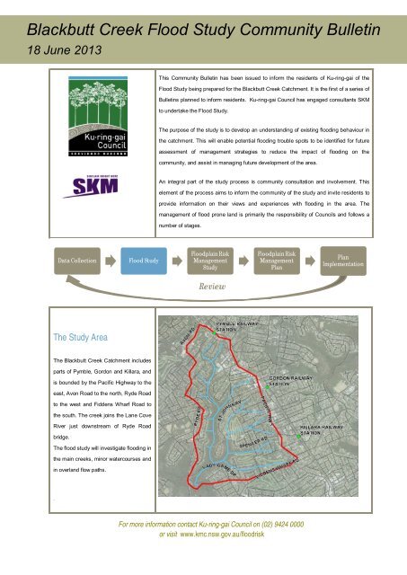
The <strong>Study</strong> Area<br />
The <strong>Blackbutt</strong> <strong>Creek</strong> Catchment includes<br />
parts of Pymble, Gordon and Killara, and<br />
is bounded by the Pacific Highway to the<br />
east, Avon Road to the north, Ryde Road<br />
to the west and Fiddens Wharf Road to<br />
the south. The creek joins the Lane Cove<br />
River just downstream of Ryde Road<br />
bridge.<br />
The flood study will investigate flooding in<br />
the main creeks, minor watercourses and<br />
in overland flow paths.<br />
.<br />
For more information contact <strong>Ku</strong>-<strong>ring</strong>-<strong>gai</strong> <strong>Council</strong> on (02) 9424 0000<br />
or visit www.kmc.nsw.gov.au/floodrisk
The <strong>Flood</strong> Problem<br />
Steep terrain and ridge-top development<br />
has led to major flood risk in <strong>Ku</strong>-<strong>ring</strong>-<strong>gai</strong>,<br />
arising from flash flooding along<br />
headwater streams and drainage<br />
Have you experienced<br />
flooding?<br />
Some of the most important<br />
information for the study is collected<br />
from residents and local business<br />
depressions. The speed with which the<br />
operators.<br />
We would be very<br />
flooding occurs means that there is<br />
usually no time for damage reduction<br />
measures to be put in place, or for<br />
evacuation to be undertaken as required.<br />
The <strong>Blackbutt</strong> <strong>Creek</strong> Catchment is one of<br />
<strong>Ku</strong>-<strong>ring</strong>-<strong>gai</strong>’s most significantly flood<br />
affected areas.<br />
Objectives of the <strong>Study</strong><br />
1) Understand the current flooding<br />
interested to receive records of<br />
flooding in your area including<br />
photographs, observations of flood depths or some comments on your experience. You<br />
can help us with this information by completing the questionnaire which will be<br />
distributed in the mail.<br />
How can you get involved?<br />
Engagement of the community in the floodplain risk management process is very<br />
important to <strong>Council</strong>. We will be providing a number of opportunities for the community<br />
to have input to the floodplain risk management plan. These are outlined below.<br />
patterns in the study area<br />
2) Construct a computer flood model<br />
which can be used to simulate the<br />
size and extent of potential future<br />
floods.<br />
3) Identify potential problem areas for<br />
further investigation.<br />
<strong>Community</strong><br />
<strong>Bulletin</strong>s<br />
<strong>Flood</strong><br />
Questionnaire<br />
•Background to the study and context<br />
•<strong>Bulletin</strong>s to update community on the project progress<br />
•An opportunity to tell us about flooding in your area (via a<br />
questionnaire)<br />
<strong>Flood</strong>plain Advisory<br />
Committee<br />
A <strong>Flood</strong>plain Advisory Committee is<br />
being formed which includes<br />
representatives from State Agencies,<br />
<strong>Community</strong><br />
Forums<br />
<strong>Council</strong><br />
website<br />
•Opportunity to find out more about flood studies for your<br />
area and provide some feedback<br />
•Contact details for queries relating to the study and how<br />
you can be involved.<br />
Emergency Services and <strong>Council</strong>. The<br />
Committee will meet regularly to oversee<br />
and guide the flood study and overall<br />
floodplain risk management process.<br />
Interested community members will have<br />
another chance to join the Committee<br />
later in 2013.<br />
<strong>Council</strong>’s floodplain risk management website is currently being developed and will be<br />
ready later in 2013. Details will be made available in an upcoming <strong>Community</strong> <strong>Bulletin</strong>.<br />
Timeframes<br />
Completion of <strong>Flood</strong> <strong>Study</strong> – April 2014<br />
For more information contact <strong>Ku</strong>-<strong>ring</strong>-<strong>gai</strong> <strong>Council</strong> on (02) 9424 0000<br />
or visit www.kmc.nsw.gov.au/floodrisk