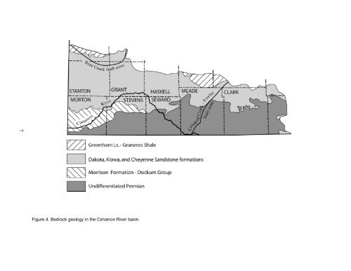
7 Figure 4. Bedrock geology <strong>in</strong> <strong>the</strong> Cimarron River bas<strong>in</strong>.
Kearny <strong>and</strong> sou<strong>the</strong>rn Hamilton counties <strong>and</strong> to <strong>the</strong> east <strong>in</strong> Gray County, <strong>the</strong> youngest bedrock units are <strong>the</strong> Cretaceous chalks <strong>and</strong> marls of <strong>the</strong> Carlile Shale <strong>and</strong> <strong>the</strong> Greenhorn Limestone. None of <strong>the</strong>se units is known to conta<strong>in</strong> significant amounts of evaporites. The undifferentiated Quaternary <strong>and</strong> Tertiary Ogallala Formation sediments that compose <strong>the</strong> High Pla<strong>in</strong>s aquifer consist of clay, silt, s<strong>and</strong>, <strong>and</strong> gravel. Aquifer characteristics are described <strong>in</strong> more detail <strong>in</strong> follow<strong>in</strong>g sections of this report. The unconsolidated sediments were deposited largely by eastward flow<strong>in</strong>g streams. W<strong>in</strong>d-blown deposits of dune s<strong>and</strong> <strong>and</strong> loess mantle much of <strong>the</strong> surface, except along <strong>the</strong> major river/stream valleys (Figure 3). The total thickness of <strong>the</strong>se unconsolidated deposits ranges up to more than 500 ft <strong>in</strong> parts of Seward, Stevens, <strong>and</strong> Haskell counties. The bedrock surface between <strong>the</strong> Bear Creek <strong>and</strong> Crooked Creek-Fowler faults generally slopes at about 13.5 ft/mi to <strong>the</strong> east-sou<strong>the</strong>ast from southwest Stanton County to <strong>the</strong> town of Meade <strong>in</strong> Meade County (Stullken et al., 1985). Local relief may be as much as 250 ft across <strong>the</strong> fault zones, which are <strong>the</strong> result of dissolution <strong>and</strong> subsidence (discussed more <strong>in</strong> <strong>the</strong> follow<strong>in</strong>g section). REGIONAL AND LOCAL GEOLOGIC STRUCTURE In this part of southwest Kansas, <strong>the</strong> bedrock units are tilted to <strong>the</strong> east <strong>and</strong> nor<strong>the</strong>ast away from <strong>the</strong> Sierra Gr<strong>and</strong>e uplift <strong>in</strong> Baca County, sou<strong>the</strong>ast Colorado (Gutentag et al., 1981; Macfarlane, 1993). Gutentag et al. (1981) show <strong>the</strong> dip of <strong>the</strong> Permian units near <strong>the</strong> bedrock surface steepen<strong>in</strong>g <strong>in</strong> Morton <strong>and</strong> Stanton counties from approximately 9 ft/mi to more than 35 ft/mi near <strong>the</strong> Sierra Gr<strong>and</strong>e uplift <strong>in</strong> sou<strong>the</strong>astern Colorado. The regional geologic structure has been modified by widespread <strong>and</strong> cont<strong>in</strong>u<strong>in</strong>g evaporite dissolution <strong>in</strong> <strong>the</strong> bedrock <strong>and</strong> collapse of overly<strong>in</strong>g units from local to regional scale. Substantial thicknesses of bedded salt <strong>and</strong> gypsum are present <strong>in</strong> <strong>the</strong> bedrock units with<strong>in</strong> <strong>the</strong> upper 1,000 ft of <strong>the</strong> subsurface <strong>in</strong> <strong>the</strong> Nippewalla Group (Merriam, 1963) <strong>in</strong> southwest Kansas (Frye, 1950). The Bear Creek (<strong>in</strong> Hamilton, Kearny, Stanton, <strong>and</strong> Grant counties) <strong>and</strong> <strong>the</strong> Crooked Creek-Fowler (<strong>in</strong> Meade <strong>and</strong> Ford counties) fault zones, shown on Figure 1, def<strong>in</strong>e an area <strong>in</strong> southwest Kansas where circulat<strong>in</strong>g ground waters have dissolved out <strong>and</strong> removed halite <strong>and</strong> o<strong>the</strong>r evaporite m<strong>in</strong>erals from <strong>the</strong> Bla<strong>in</strong>e Formation, Flower-pot Shale, <strong>and</strong> Stone Corral Formation (Frye, 1950; Walters, 1978; Gutentag et al., 1981). Vertical displacement is as much as 250 ft along <strong>the</strong> Bear Creek <strong>and</strong> Crooked Creek- Fowler faults. The Crooked Creek-Fowler fault was <strong>in</strong>itially mapped as two faults <strong>in</strong> Meade County (Frye <strong>and</strong> Schoff, 1942; Merriam, 1963). Later, Gutentag et al. (1981) argued that s<strong>in</strong>ce both faults are part of <strong>the</strong> same zone of dissolution <strong>and</strong> collapse, <strong>the</strong>ir names should be comb<strong>in</strong>ed to <strong>in</strong>dicate <strong>the</strong>ir genetic relationship. Sp<strong>in</strong>azola <strong>and</strong> Dealy (1983) used geophysical logs to extend <strong>the</strong> Crooked Creek-Fowler fault <strong>in</strong>to sou<strong>the</strong>rn Ford County. They attributed fault<strong>in</strong>g <strong>and</strong> subsidence features <strong>in</strong> Ford County to dissolution of gypsum <strong>in</strong> <strong>the</strong> Bla<strong>in</strong>e. 8