VMRS Buzzards Bay User Manual - Towmasters: the Master of ...
VMRS Buzzards Bay User Manual - Towmasters: the Master of ...
VMRS Buzzards Bay User Manual - Towmasters: the Master of ...

You also want an ePaper? Increase the reach of your titles
YUMPU automatically turns print PDFs into web optimized ePapers that Google loves.
<strong>VMRS</strong> BUZZARDS BAY<br />
USER MANUAL<br />
OPERATED BY<br />
UNITED STATES COAST GUARD<br />
AND<br />
US ARMY CORPS OF ENGINEERS<br />
Enhancing safe, environmentally sound and efficient<br />
maritime transportation on <strong>the</strong> waters <strong>of</strong> <strong>Buzzards</strong> <strong>Bay</strong><br />
and <strong>the</strong> Cape Cod Canal<br />
REVISED NOVEMBER 2007
<strong>VMRS</strong> BUZZARDS BAY<br />
USER MANUAL<br />
Table <strong>of</strong> Contents<br />
Acronyms and Abbreviations 2<br />
Important Phone Numbers and Frequencies 3<br />
Introduction 4<br />
Concept <strong>of</strong> Operations 5<br />
Who Must Participate 6<br />
Communications 7<br />
Reporting Procedures for Active <strong>User</strong>s 8-9<br />
O<strong>the</strong>r Reports – All <strong>User</strong>s 10-11<br />
Good Things to Know 12<br />
Aids to Navigation 12<br />
Example <strong>User</strong> Matrix 13<br />
Appendix A – <strong>VMRS</strong> <strong>Buzzards</strong> <strong>Bay</strong> Sector Border and Frequency Chartlet<br />
Appendix B – <strong>VMRS</strong> <strong>Buzzards</strong> <strong>Bay</strong> Reporting Points<br />
Appendix C – <strong>VMRS</strong> <strong>Buzzards</strong> <strong>Bay</strong> Reporting Points Chartlets<br />
Appendix D – Regulated Navigation Area Regulations (33 CFR 165.100)<br />
Appendix E - National Vessel Traffic Management Regulations (33 CFR 161)<br />
Appendix F – Bridge to Bridge Radiotelephone Regulations (33 CFR 126)<br />
Appendix G – FCC Watch on 16 VHF Regulations (47 CFR 80.148)<br />
Appendix H- Determination <strong>of</strong> Materials that are Hazardous (46 CFR 153.40)<br />
Appendix I- Cape Cod Canal Regulations (33 CFR 207.20)<br />
1
<strong>VMRS</strong> BUZZARDS BAY<br />
USER MANUAL<br />
Acronyms and Abbreviations<br />
AIS<br />
BBC<br />
CCC<br />
CFR<br />
LLNR<br />
MTC<br />
RNA<br />
USCG<br />
<strong>VMRS</strong><br />
VMC<br />
Automatic Identification System<br />
<strong>Buzzards</strong> <strong>Bay</strong> Control<br />
Cape Cod Canal Control<br />
Code <strong>of</strong> Federal Regulations<br />
Light List Number<br />
Marine Traffic Controller<br />
Regulated Navigation Area<br />
United States Coast Guard<br />
Vessel Movement Reporting System<br />
Vessel Movement Center<br />
2
<strong>VMRS</strong> BUZZARDS BAY<br />
USER MANUAL<br />
Important Phone Numbers and Frequencies<br />
Name Telephone Call Sign /<br />
VHF Channel<br />
U.S. Army Corps <strong>of</strong> Engineers<br />
<strong>Buzzards</strong> <strong>Bay</strong> Vessel Movement Center<br />
U.S. Army Corps <strong>of</strong> Engineers<br />
Marine Traffic Control Center<br />
U.S. Coast Guard<br />
Sector Sou<strong>the</strong>aster New England<br />
http://homeport.uscg.mil/sou<strong>the</strong>asternnewengland<br />
U.S. Coast Guard<br />
National Response Center<br />
U.S. Coast Guard<br />
Navigation Center<br />
http://www.navcen.uscg.gov/<br />
978-318-8500<br />
(24 Hours)<br />
Fax: 508-743-9348<br />
978-318-8500<br />
(24 Hours)<br />
Fax: 508-743-9348<br />
Primary Phone: 866-816-9128<br />
Emergency Phone: 508-457-3211<br />
Fax Number: 508-457-3397<br />
1-800-424-8802<br />
(24 hours)<br />
(703) 313-5900<br />
Nor<strong>the</strong>ast Marine Pilots 800-274-1216<br />
401-847-9050<br />
Boston Coastwise Pilots 617-510-0082<br />
508-801-4904<br />
<strong>Buzzards</strong> <strong>Bay</strong><br />
Control<br />
12,13<br />
Canal<br />
Control<br />
13,14<br />
USCG Sector<br />
Sou<strong>the</strong>astern<br />
New England<br />
16<br />
Nor<strong>the</strong>ast<br />
Marine Pilots<br />
10<br />
3
<strong>VMRS</strong> BUZZARDS BAY<br />
USER MANUAL<br />
Introduction<br />
<strong>Buzzards</strong> <strong>Bay</strong> Control (BBC) began operations in 2007 to promote<br />
vessel safety and environmental protection by establishing a Vessel<br />
Movement Reporting System to monitor vessel movements within<br />
<strong>the</strong> bay.<br />
To accomplish <strong>the</strong>se goals BBC uses AIS, radar, and radiotelephone<br />
reports from vessel operators to monitor and inform mariners about<br />
reported marine traffic, <strong>the</strong> status <strong>of</strong> <strong>the</strong> waterway and any additional<br />
information, advice or recommendations which may affect vessel<br />
traffic safety within <strong>the</strong> <strong>VMRS</strong> area.<br />
Through proactive exchange <strong>of</strong> information with mariners, BBC<br />
endeavors to maintain good order and predictability <strong>of</strong> <strong>the</strong> waterway<br />
This <strong>VMRS</strong> <strong>Buzzards</strong> <strong>Bay</strong> <strong>User</strong> <strong>Manual</strong> is intended to describe <strong>the</strong><br />
services available to waterway users and provide <strong>the</strong> information<br />
necessary for participation within <strong>the</strong> <strong>VMRS</strong> area. It is derived from<br />
a Memorandum <strong>of</strong> Understanding (MOU) between <strong>the</strong> United States<br />
Coast Guard and <strong>the</strong> United States Army Corps <strong>of</strong> Engineers.<br />
This <strong>Manual</strong> is not intended to conflict with or modify any existing<br />
regulations in any respect, and vessels within <strong>the</strong> <strong>VMRS</strong> area shall be<br />
responsible for <strong>the</strong>ir safe navigation in accordance with existing<br />
Federal, State and local rules.<br />
Suggested<br />
Improvements<br />
The Coast Guard welcomes any suggestions to improve this manual<br />
or <strong>VMRS</strong> operational procedures. Suggestions may be forwarded to<br />
Sector Sou<strong>the</strong>astern New England at <strong>the</strong> address or website listed on<br />
<strong>the</strong> previous page.<br />
4
<strong>VMRS</strong> BUZZARDS BAY<br />
USER MANUAL<br />
Concept <strong>of</strong> Operations<br />
<strong>VMRS</strong> Description<br />
<strong>Buzzards</strong> <strong>Bay</strong> Vessel Movement Reporting System is comprised <strong>of</strong><br />
two sectors, <strong>Buzzards</strong> <strong>Bay</strong> Control and Cape Cod Canal Control.<br />
<strong>Buzzards</strong> <strong>Bay</strong> Control (BBC) sector extends from <strong>the</strong> entrance to<br />
<strong>Buzzards</strong> <strong>Bay</strong>, as defined by 33 CFR 165.100, to Cleveland Ledge<br />
Light, excluding New Bedford Harbor north <strong>of</strong> <strong>the</strong> hurricane<br />
barrier and <strong>the</strong> channels between <strong>the</strong> Elizabethan Islands.<br />
• The Coast Guard will enforce <strong>the</strong> <strong>VMRS</strong> reporting<br />
requirements for vessels operating within this sector in<br />
accordance with <strong>the</strong> guidelines provided in this manual.<br />
Cape Cod Canal Control (CCC) sector extends along <strong>the</strong><br />
federally maintained channel limits from Cleveland Ledge Light to<br />
1.6 statute miles seaward <strong>of</strong> <strong>the</strong> Canal Breakwater light into Cape<br />
Cod <strong>Bay</strong>, as defined by 33 CFR 207.20(a).<br />
• Vessels movements within <strong>the</strong> Canal are controlled by <strong>the</strong><br />
Corps <strong>of</strong> Engineers under Canal regulations contained in 33<br />
CFR 207.20. Following Canal regulations also satisfies<br />
<strong>VMRS</strong> participation requirements in this sector. Canal<br />
regulations can be found in Appendix I to this manual.<br />
BBC Services<br />
In order to promote vessel safety and environmental protection<br />
BBC provides information services:<br />
• Information Services – BBC will provide <strong>the</strong> position,<br />
identity, and intentions <strong>of</strong> vessels known to be operating<br />
within <strong>the</strong> <strong>VMRS</strong> area. It also will provide information on<br />
<strong>the</strong> status <strong>of</strong> major aids to navigation (ATON), known<br />
hazards to navigation and waterway restrictions.<br />
This service assists <strong>the</strong> mariner in making independent decisions<br />
regarding <strong>the</strong> safe navigation <strong>of</strong> <strong>the</strong>ir vessels, for which <strong>the</strong>y retain<br />
complete responsibility. In this sense, we regard ourselves as a<br />
navigational aid, a tool that mariners use along with numerous<br />
o<strong>the</strong>r tools to facilitate <strong>the</strong>ir safe navigation.<br />
MARINERS ARE CAUTIONED THAT BBC MAY NOT<br />
KNOW OF ALL VESSELS OR HAZARDOUS CIRCUM-<br />
STANCES WITHIN THE <strong>VMRS</strong> AREA. UNREPORTED<br />
HAZARDS MAY CONFRONT MARINERS AT ANY TIME.<br />
ANY CONFLICTING CIRCUMSTANCES OR HAZARDOUS<br />
CONDITIONS SHOULD BE REPORTED TO BBC<br />
IMMEDIATELY.<br />
5
<strong>VMRS</strong> BUZZARDS BAY<br />
USER MANUAL<br />
Who Must Participate<br />
Applicability<br />
Title 33 CFR § 165.100 and Table 161.12(c) denote those vessels<br />
required to participate in <strong>VMRS</strong> <strong>Buzzards</strong> <strong>Bay</strong>. To avoid unduly<br />
congesting radiotelephone frequencies. <strong>VMRS</strong> participants are<br />
broken into two categories <strong>of</strong> waterway users:<br />
1. Active <strong>User</strong>s<br />
2. Passive <strong>User</strong>s<br />
*See Appendix E for <strong>VMRS</strong> Regulations, Appendix F for <strong>the</strong> Radiotelephone Act<br />
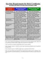
Active <strong>User</strong> Every vessel subject to 33 CFR 161.16:<br />
• Every power-driven vessel <strong>of</strong> 40 meters (approx. 131 feet) or<br />
more in length, while navigating;<br />
• Every towing vessel <strong>of</strong> 8 meters (approx. 26 feet) or more in<br />
length, while engaged in towing;<br />
• Every vessel certificated to carry 50 or more passengers for<br />
hire, while engaged in trade, but not operating on a published<br />
schedule.<br />
Active <strong>User</strong>s<br />
Must:<br />
Passive <strong>User</strong>s<br />
1. Monitor <strong>the</strong> <strong>VMRS</strong> radio frequency (12 VHF) at all times<br />
while operating within <strong>the</strong> <strong>VMRS</strong> Area and respond promptly<br />
when hailed.<br />
2. Make vessel movement reports to <strong>VMRS</strong> <strong>Buzzards</strong> <strong>Bay</strong> as<br />
described in <strong>the</strong> “reporting procedures” section <strong>of</strong> this manual<br />
Every vessel subject to <strong>the</strong> Vessel Bridge-to-Bridge Radiotelephone<br />
Act, as set forth in 33 CFR Part 26, or identified in 33 CFR 161.16:<br />
• Every power-driven vessel <strong>of</strong> 20 meters (approximately 65<br />
feet) or more in length while navigating;<br />
• Every vessel <strong>of</strong> 100 gross tons and upward carrying one or<br />
more passengers for hire;<br />
• Every vessel certificated to carry 50 or more passengers for<br />
hire, while engaged in trade within a published schedule.<br />
• Every towing vessel <strong>of</strong> 26 feet or more in length while<br />
navigating and not engaged in towing.<br />
• Every dredge or floating plant engaged in or near a channel or<br />
fairway in operations likely to restrict or affect navigation <strong>of</strong><br />
o<strong>the</strong>r vessels except for an unmanned or intermittently<br />
manned floating plant under <strong>the</strong> control <strong>of</strong> a dredge.<br />
6
<strong>VMRS</strong> BUZZARDS BAY<br />
USER MANUAL<br />
Passive <strong>User</strong>s<br />
Must:<br />
Non-<br />
Participants<br />
Responsibilities<br />
All <strong>User</strong>s:<br />
Active, Passive and<br />
non-participant<br />
Monitor <strong>the</strong> <strong>VMRS</strong> radio frequency (12 VHF) at all times while<br />
operating within <strong>the</strong> <strong>VMRS</strong> Area and respond promptly when<br />
hailed.<br />
Vessel that are not required to participate in <strong>the</strong> <strong>VMRS</strong> but are<br />
operating within <strong>the</strong> <strong>VMRS</strong> area are encouraged to:<br />
• Monitor <strong>VMRS</strong> radiotelephone frequencies.<br />
• Contact BBC on an as needed basis to obtain information on<br />
large commercial vessel traffic operating in <strong>the</strong> area.<br />
• Not interfere with large commercial vessels utilizing <strong>the</strong><br />
voluntary recommended vessel route<br />
The safe operation <strong>of</strong> a vessel remains <strong>the</strong> responsibility <strong>of</strong><br />
<strong>the</strong> vessel master. If, in a specific circumstance, a <strong>VMRS</strong><br />
<strong>User</strong> is unable to safely comply with a measure or direction<br />
issued by <strong>the</strong> Coast Guard Captain <strong>of</strong> <strong>the</strong> Port or an Army<br />
Corps Marine Traffic Controller, <strong>the</strong> <strong>VMRS</strong> <strong>User</strong> may<br />
deviate only to <strong>the</strong> extent necessary to avoid endangering<br />
persons, property or <strong>the</strong> environment. The deviation shall be<br />
reported to <strong>the</strong> <strong>VMRS</strong> as soon as practicable.<br />
Communications<br />
Voice Call Signs<br />
and<br />
Designated<br />
Frequencies<br />
Listening Watch<br />
English Language<br />
"BUZZARDS BAY CONTROL" is <strong>the</strong> voice call sign for <strong>VMRS</strong><br />
<strong>Buzzards</strong> <strong>Bay</strong>. Use Channel 12 VHF-FM (156.650 MHz) for<br />
communicating with BBC. Monitor 12 & 13 VHF while transiting.<br />
“CANAL CONTROL” Is <strong>the</strong> voice call sign for Cape Cod Canal<br />
Control. Use Channel 14 VHF-FM (156.750 MHz) for<br />
communicating with CCC. Monitor 13 VHF while transiting.<br />
<strong>Buzzards</strong> <strong>Bay</strong> Control Sector<br />
• All active and passive users shall continuously monitor<br />
channels 12 & 13 VHF-FM and respond promptly when<br />
hailed, while operating in this sector, as required by <strong>VMRS</strong><br />
regulations in 33 CFR 161.12 and <strong>the</strong> Radio Telephone Act.<br />
Canal Control Sector<br />
• All vessels shall continuously monitor channel 13 VHF-FM<br />
and respond promptly when hailed, while operating in this<br />
sector, as required by Canal regulations 33 CFR 207.20.<br />
All communications must be in <strong>the</strong> English language.<br />
7
<strong>VMRS</strong> BUZZARDS BAY<br />
USER MANUAL<br />
Reporting Procedures -<strong>VMRS</strong> <strong>Buzzards</strong> <strong>Bay</strong> Active <strong>User</strong>s<br />
Report Types<br />
The following reports are required from Active <strong>User</strong>s to provide<br />
necessary information to BBC so watch standers can utilize and pass<br />
timely, relevant and accurate information to <strong>VMRS</strong> users:<br />
1. Sailing Plan (Check-In)<br />
2. Sail Plan Deviation (Destination or route change)<br />
3. Position Report (Passing designated reporting points)<br />
(Note: If a vessel has a properly functioning AIS, <strong>the</strong><br />
requirement to provide position reports by voice is<br />
waived.)<br />
4. Meeting, Crossing or Overtaking Notification Report<br />
5. Final Report (Check-Out)<br />
Sailing Plan<br />
(Check-In)<br />
Active <strong>User</strong>s must report <strong>the</strong> following information via VHF-FM<br />
prior to entering or getting underway within <strong>the</strong> <strong>VMRS</strong> (preferably<br />
in this order):<br />
1. Vessel Name<br />
2. Location<br />
3. Destination (include any anticipated stops)<br />
4. Tow Configuration (How many and # <strong>of</strong> loaded/unloaded<br />
barges)<br />
5. Vessel's Dimensions (Length x beam x draft) and air draft<br />
(ships only)<br />
6. Inoperable or malfunctioning vessel equipment such as<br />
propulsion, machinery, steering gear, radar system,<br />
gyrocompass, depth sounding device, automatic radar<br />
plotting aid (ARPA), radiotelephone, Automatic<br />
Identification System (AIS), navigational lighting, sound<br />
signaling devices or similar equipment. Any special<br />
circumstances or limitations <strong>of</strong> <strong>the</strong> vessel that impairs<br />
navigation or restricts maneuverability.<br />
7. Any Petroleum or Hazardous Cargo being carried (See<br />
Appendix H)<br />
8. If loaded with petroleum or hazardous cargo, pass transit<br />
intentions (i.e., intended trackline) and verify that RNA<br />
special regulations have been satisfied.<br />
9. Name <strong>of</strong> pilot and escort tug (applies only to a single-hull<br />
tank barge carrying 5000 or more barrels <strong>of</strong> oil or o<strong>the</strong>r<br />
hazardous material).<br />
8
<strong>VMRS</strong> BUZZARDS BAY<br />
USER MANUAL<br />
Sail Plan<br />
Deviation<br />
Position Report<br />
Automated<br />
Reporting<br />
(AIS)<br />
Meeting Passing<br />
Overtaking<br />
Notification<br />
Report<br />
Active <strong>User</strong>s must report any significant deviation from <strong>the</strong><br />
information given in <strong>the</strong>ir Sailing Plan Report, including but not<br />
limited to:<br />
• Change in destination.<br />
• Exiting <strong>the</strong> voluntary recommended route if intention to use<br />
<strong>the</strong> route was reported.<br />
• Any casualty, emergency or failure; or any circumstance<br />
which causes <strong>the</strong> vessel to become out <strong>of</strong> compliance with <strong>the</strong><br />
RNA special regulations.<br />
Active <strong>User</strong>s must contact BBC with name and position when<br />
passing <strong>the</strong> following Reporting Points:<br />
• <strong>Buzzards</strong> <strong>Bay</strong> Entrance Light Tower (41-23.48N, 071-<br />
02.01W) LLNR15985<br />
• <strong>Buzzards</strong> <strong>Bay</strong> Lighted Bell Buoy #4 (41-27.02 N, 070-<br />
59.14W) LLNR16025<br />
• <strong>Buzzards</strong> <strong>Bay</strong> Midchannel Lighted Bell Bouy BB (41-<br />
30.33N, 070-49.54W) LLNR16055<br />
• <strong>Buzzards</strong> <strong>Bay</strong> Lighted Gong Buoy #10 (41-34.37N, 070-<br />
43.15W) LLNR16060<br />
• Cleveland East Ledge Light (14-37.51N, 070-41.39W)<br />
LLNR16080<br />
• Any o<strong>the</strong>r location when directed by BBC<br />
*See Appendix B for a table with reporting points based on direction<br />
Active <strong>User</strong>s with properly operating AIS equipment are exempt<br />
from <strong>the</strong> requirement to submit “Position Reports” on Channel 12<br />
VHF-FM, unless directed to do so by BBC. This does not relieve <strong>the</strong><br />
active user from checking in to or out <strong>of</strong> <strong>the</strong> <strong>VMRS</strong>.<br />
All Active <strong>User</strong>s must, before meeting, crossing, or overtaking any<br />
o<strong>the</strong>r <strong>VMRS</strong> user in <strong>the</strong> area, communicate with that user on <strong>the</strong><br />
designated vessel bridge-to-bridge radiotelephone frequency Channel<br />
13 VHF-FM (156.700 MHz), intended navigation movements, and<br />
any o<strong>the</strong>r information necessary in order to make safe passing<br />
arrangements.<br />
Channel 13 VHF-FM will be continuously monitored by BBC watch<br />
standers. Therefore communications between <strong>VMRS</strong> users for safe<br />
passing arrangements made on Channel 13 VHF-FM will satisfy<br />
BBC notification requirements.<br />
This requirement does not relieve a vessel <strong>of</strong> any duty prescribed<br />
by <strong>the</strong> International Regulations for Prevention <strong>of</strong> Collisions at<br />
Sea, 1972 (72 COLREGS) or <strong>the</strong> Inland Navigation Rules.<br />
9
<strong>VMRS</strong> BUZZARDS BAY<br />
USER MANUAL<br />
Final Report<br />
Active <strong>User</strong>s must report its name and position:<br />
• On arrival at its destination within <strong>the</strong> VRMS; or<br />
• When leaving <strong>the</strong> <strong>VMRS</strong> area.<br />
Emergencies<br />
In emergencies, any vessel may deviate from any rule in this manual<br />
to <strong>the</strong> extent necessary to avoid endangering, persons, property, or<br />
<strong>the</strong> environment. When an emergency arises and it becomes<br />
necessary to deviate from <strong>the</strong> rules for reason <strong>of</strong> safety, <strong>the</strong> vessel<br />
operator shall report or cause to be reported <strong>the</strong> deviation as soon as<br />
possible to BBC.<br />
O<strong>the</strong>r Reports – All <strong>User</strong>s<br />
Voice report to BBC or CCC any grounding, fire, loss <strong>of</strong> steering,<br />
loss <strong>of</strong> propulsion, collisions, rammings, flooding, or o<strong>the</strong>r<br />
circumstance that reduces <strong>the</strong> capability <strong>of</strong> a vessel to safely<br />
maneuver or that endangers ano<strong>the</strong>r vessel. Include in your report<br />
<strong>the</strong> following information:<br />
1. Marine Casualty as defined in 46 CFR Part 4.05-1<br />
• Vessel name<br />
• Location<br />
• Nature <strong>of</strong> incident<br />
• If Coast Guard assistance is needed<br />
• Extent <strong>of</strong> channel restrictions<br />
• Is <strong>the</strong>re damage, pollution, or injuries as a result <strong>of</strong> <strong>the</strong><br />
incident;<br />
• <strong>Master</strong>'s intentions<br />
2. Involvement in <strong>the</strong> collision/allision <strong>of</strong> a fixed or floating<br />
object.<br />
3. A pollution incident as defined in 33 CFR Part 151.15.<br />
4. A defect or discrepancy in an aid to navigation.<br />
Report any discrepancy to an aid to navigation including:<br />
• Lights not working<br />
• Lights showing <strong>the</strong> wrong characteristics<br />
• Aids in <strong>the</strong> wrong location<br />
• Missing aids<br />
10
<strong>VMRS</strong> BUZZARDS BAY<br />
USER MANUAL<br />
Note - Vessel operators are required to report striking<br />
any aid to navigation.<br />
5. A hazardous condition as defined in 33 CFR Part 160.204.<br />
6. Improper operation <strong>of</strong> vessel equipment required by 33 CFR,<br />
Part 16.<br />
7. A hazardous vessel operating condition (33 CFR Part<br />
161.2) including, but not limited to:<br />
• Malfunction <strong>of</strong> vessel operating equipment such as<br />
propulsion, machinery, steering gear, radar system,<br />
gyrocompass, depth sounding device, automatic radar<br />
plotting aid (ARPA), radiotelephone, Automatic<br />
Identification System (AIS), navigational lighting,<br />
sound signaling devices or similar equipment.<br />
• Any condition on board <strong>the</strong> vessel likely to impair<br />
navigation such as lack <strong>of</strong> current nautical charts and<br />
publications, personnel shortage, or similar condition.<br />
Dredges And<br />
Floating Plants<br />
Dredges and floating plants must provide <strong>the</strong> following information<br />
to <strong>the</strong> <strong>VMRS</strong> prior to beginning operations within <strong>the</strong> <strong>VMRS</strong> Area:<br />
• Name<br />
• Location and duration <strong>of</strong> intended operation<br />
• Description <strong>of</strong> intended operation – including any channel<br />
obstructions<br />
• Configuration <strong>of</strong> pipeline<br />
• Termination point <strong>of</strong> pipelines<br />
• Time required to re-open <strong>the</strong> channel for vessel passage<br />
• Any operating impairments<br />
• Any notification requirements to channel traffic<br />
• (e.g., requests for SLOWBELL, no meeting or overtaking,<br />
divers in <strong>the</strong> water, etc.<br />
• Means <strong>of</strong> contacting <strong>the</strong> dredge control station<br />
• Telephone numbers and names <strong>of</strong> assist vessels<br />
• Telephone number and name <strong>of</strong> project superintendent<br />
11
<strong>VMRS</strong> BUZZARDS BAY<br />
USER MANUAL<br />
Good Things to Know<br />
Regulated<br />
Navigation Area<br />
(RNA)<br />
A Regulated Navigation Area exists for waters within <strong>the</strong> first district<br />
including <strong>Buzzards</strong> <strong>Bay</strong> and <strong>the</strong> Cape Cod Canal. The RNA is<br />
attached in Appendix D<br />
Aids to Navigation<br />
Aids to<br />
Navigation<br />
(AtoN)<br />
<strong>VMRS</strong> <strong>Buzzards</strong> <strong>Bay</strong> monitors <strong>the</strong> status <strong>of</strong> only major aids to<br />
navigation within <strong>the</strong> <strong>VMRS</strong> Area. For more detailed information<br />
US Coast Guard Sector Sou<strong>the</strong>astern New England performs a<br />
scheduled Broadcast Notice to Mariners which informs <strong>of</strong> aids to<br />
navigation discrepancy information, including aids within <strong>the</strong><br />
<strong>Buzzards</strong> <strong>Bay</strong> <strong>VMRS</strong> Area, on Channel 22A. Consult light list<br />
publication for complete list <strong>of</strong> Aids to Navigation.<br />
Note - Vessel operators are required to report striking any aid<br />
to navigation.<br />
12
<strong>VMRS</strong> BUZZARDS BAY<br />
USER MANUAL<br />
Example <strong>User</strong> Matrix<br />
Type <strong>of</strong> Vessel<br />
Towing vessel over 26 feet, engaged in towing<br />
Towing vessel over 26 feet, not engaged in towing<br />
Power Driven vessel 131 feet or more in length<br />
Power Driven vessel 65 feet or more, but less than<br />
131 feet in length<br />
Vessel certificated to carry 50 or more passengers<br />
not on a published schedule<br />
Vessel certificated to carry 50 or more passengers<br />
on a published schedule<br />
Examples<br />
Active Or Passive<br />
Active<br />
Passive<br />
Active<br />
Passive<br />
Active<br />
Passive<br />
50 foot tugboat pushing a small deck barge Active<br />
50 foot tug towing a small tank barge carrying less<br />
Active<br />
than 5,000 barrels <strong>of</strong> oil<br />
100 foot tug towing 400 foot double hulled barge Active<br />
80 foot ferry certificated to carry 150 passengers Active<br />
80 foot passenger vessel with 150 passengers on<br />
Active<br />
an unscheduled route<br />
80 foot passenger vessel with 150 passengers on a<br />
Passive<br />
scheduled (published) route<br />
80 foot ferry certificated to carry 49 passengers Passive<br />
80 foot commercial fishing vessels Passive<br />
Towboat under 26 feet in length<br />
Exempt<br />
Sail or Power vessel under 65 feet in length<br />
Exempt<br />
13
<strong>VMRS</strong> BUZZARDS BAY<br />
USER MANUAL<br />
Appendix A <strong>VMRS</strong> <strong>Buzzards</strong> <strong>Bay</strong> Sectors and Listening Watch Frequencies<br />
14
<strong>VMRS</strong> BUZZARDS BAY<br />
USER MANUAL<br />
Appendix B<br />
<strong>VMRS</strong> BUZZARDS BAY Reporting Points<br />
Eastbound<br />
Name Description Latitude/Longitude Notes<br />
1 <strong>Buzzards</strong> <strong>Bay</strong><br />
Entrance Tower<br />
Lighted Tower 41 23.48 N<br />
071 02.01 W<br />
Sailing<br />
Plan<br />
2 #4 Buoy<br />
<strong>Buzzards</strong> <strong>Bay</strong><br />
Lighted Bell<br />
Buoy<br />
41 27.02 N<br />
070 59.14 W<br />
Position<br />
Report<br />
3 BB Buoy Lighted Bell<br />
Buoy<br />
41 30.33 N<br />
070 49.54 W<br />
Position<br />
Report<br />
4 #10 Buoy<br />
<strong>Buzzards</strong> <strong>Bay</strong><br />
Lighted Gong<br />
Buoy<br />
41 34.37 N<br />
070 43.15 W<br />
Position<br />
Report<br />
5 Cleveland East<br />
Ledge Light<br />
Light House 41 37.51 N<br />
070 41.39 W<br />
Final<br />
Report<br />
<strong>VMRS</strong> BUZZARDS BAY Reporting Points<br />
Westbound<br />
Name Description Latitude/Longitude Notes<br />
1 Cleveland East<br />
Ledge Light<br />
Light House 41 37.51 N<br />
070 41.39 W<br />
Sailing<br />
Plan<br />
2 #10 Buoy <strong>Buzzards</strong><br />
<strong>Bay</strong><br />
Lighted Gong<br />
Buoy<br />
41 34.37 N<br />
070 43.15 W<br />
Position<br />
Report<br />
3 BB Buoy Lighted Bell<br />
Buoy<br />
41 30.33 N<br />
070 49.54 W<br />
Position<br />
Report<br />
4 #4 Buoy<br />
<strong>Buzzards</strong> <strong>Bay</strong><br />
Lighted Bell<br />
Buoy<br />
41 27.02 N<br />
070 59.14 W<br />
Position<br />
Report<br />
5 <strong>Buzzards</strong> <strong>Bay</strong><br />
Entrance Tower<br />
Lighted Tower 41 23.48 N<br />
071 02.01 W<br />
Final<br />
Report<br />
North & South Bound Vessels:<br />
*Active <strong>User</strong> vessels entering <strong>the</strong> <strong>VMRS</strong> area from points North or<br />
South shall, upon crossing <strong>the</strong> <strong>VMRS</strong> boundary, file a sail plan or<br />
final report with BBC as appropriate and file position reports when<br />
passing reporting points in <strong>the</strong> <strong>VMRS</strong> area.<br />
*Passive <strong>User</strong> vessels entering <strong>the</strong> <strong>VMRS</strong> area from points North or<br />
South shall begin to monitor <strong>the</strong> <strong>VMRS</strong> frequency upon crossing<br />
any <strong>VMRS</strong> boundary.<br />
15
<strong>VMRS</strong> BUZZARDS BAY<br />
USER MANUAL<br />
Appendix C <strong>VMRS</strong> <strong>Buzzards</strong> <strong>Bay</strong> Reporting Point Chartlets<br />
16
<strong>VMRS</strong> BUZZARDS BAY<br />
USER MANUAL<br />
Appendix C Continued <strong>VMRS</strong> <strong>Buzzards</strong> <strong>Bay</strong> Reporting Point Chartlets<br />
17
<strong>VMRS</strong> BUZZARDS BAY<br />
USER MANUAL<br />
Appendix D<br />
Regulated Navigation Area Code <strong>of</strong> Federal Regulations<br />
Title 33: Navigation and Navigable Waters<br />
PART 165—REGULATED NAVIGATION AREAS AND LIMITED ACCESS AREAS<br />
Subpart F—Specific Regulated Navigation Areas and Limited Access Areas<br />
First Coast Guard District<br />
§ 165.100 Regulated Navigation Area: Navigable waters within <strong>the</strong> First Coast Guard District.<br />
(a) Regulated navigation area. All navigable waters <strong>of</strong> <strong>the</strong> United States, as that term is used in 33 CFR 2.05–<br />
25(a), within <strong>the</strong> geographic boundaries <strong>of</strong> <strong>the</strong> First Coast Guard District, as defined in 33 CFR 3.05–1(b).<br />
(b) Definitions. Terms used in this section have <strong>the</strong> same meaning as those found in 33 CFR 157.03. Single-hull<br />
identifies any tank barge that is not a double-hull tank barge.<br />
(c) Applicability. This section applies to primary towing vessels engaged in towing tank barges carrying<br />
petroleum oil in bulk as cargo in <strong>the</strong> regulated navigation area, or as authorized by <strong>the</strong> District Commander.<br />
(d) Regulations— (1) Positive control for barges. (i) Except as provided in paragraph (d)(1)(iii) and paragraph 5<br />
<strong>of</strong> this section, each single hull tank barge, unless being towed by a primary towing vessel with twin-screw<br />
propulsion and with a separate system for power to each screw, must be accompanied by an escort tug <strong>of</strong><br />
sufficient capability to promptly push or tow <strong>the</strong> tank barge away from danger <strong>of</strong> grounding or collision in <strong>the</strong><br />
event <strong>of</strong>—<br />
(A) A propulsion failure;<br />
(B) A parted towing line;<br />
(C) A loss <strong>of</strong> tow;<br />
(D) A fire;<br />
(E) Grounding;<br />
(F) A loss <strong>of</strong> steering; or<br />
(G) Any o<strong>the</strong>r time a vessel may be operating in a Hazardous Vessel Operating Condition as defined in §161.2 <strong>of</strong><br />
this Chapter.<br />
(ii) Double-hull tank barges are exempt from paragraph (d)(1)(i) <strong>of</strong> this section.<br />
(iii) The cognizant Captain <strong>of</strong> <strong>the</strong> Port (COTP), upon written application, may authorize an exemption from <strong>the</strong><br />
requirements <strong>of</strong> paragraph (d)(1)(i) <strong>of</strong> this section for—<br />
(A) Any tank barge with a capacity <strong>of</strong> less than 25,000 barrels, operating in an area with limited depth or width<br />
such as a creek or small river; or<br />
(B) Any tank barge operating on any waters within <strong>the</strong> COTP Zone, if <strong>the</strong> operator demonstrates to <strong>the</strong><br />
satisfaction <strong>of</strong> <strong>the</strong> COTP that <strong>the</strong> barge employs an equivalent level <strong>of</strong> safety to that provided by <strong>the</strong> positive<br />
control provisions <strong>of</strong> this section. Each request for an exemption under this paragraph must be submitted in<br />
writing to <strong>the</strong> cognizant COTP no later than 7 days before <strong>the</strong> intended transit.<br />
(iv) The operator <strong>of</strong> a towing vessel engaged in towing any tank barge must immediately call for an escort or<br />
assist tug to render assistance in <strong>the</strong> event <strong>of</strong> any <strong>of</strong> <strong>the</strong> occurrences identified in paragraph (d)(1)(i) <strong>of</strong> this<br />
section.<br />
18
<strong>VMRS</strong> BUZZARDS BAY<br />
USER MANUAL<br />
(2) Enhanced communications. Each vessel engaged in towing a tank barge must communicate by radio on<br />
marine band or Very High Frequency (VHF) channel 13 or 16, and issue security calls on marine band or VHF<br />
channel 13 or 16, upon approach to <strong>the</strong> following places:<br />
(i) Execution Rocks Light (USCG Light List No. [LLNR] 21440).<br />
(ii) Matinecock Point Shoal Buoy (LLNR 21420).<br />
(iii) 32A Buoy (LLNR 21380).<br />
(iv) Cable and Anchor Reef Buoy (LLNR 21330).<br />
(v) Stratford Middle Ground Light (LLNR 21260).<br />
(vi) Old Field Point Light (LLNR 21275).<br />
(vii) Approach to Stratford Point from <strong>the</strong> south (NOAA Chart 12370).<br />
(viii) Falkner Island Light (LLNR 21170).<br />
(ix) TE Buoy (LLNR 21160).<br />
(x) CF Buoy (LLNR 21140).<br />
(xi) PI Buoy (LLNR 21080).<br />
(xii) Race Rock Light (LLNR 19815).<br />
(xiii) Valiant Rock Buoy (LLNR 19825).<br />
(xiv) Approach to Point Judith in vicinity <strong>of</strong> Block Island ferry route.<br />
(xv) <strong>Buzzards</strong> <strong>Bay</strong> Entrance Light (LLNR 630).<br />
(xvi) <strong>Buzzards</strong> <strong>Bay</strong> Midchannel Lighted Buoy (LLNR 16055)<br />
(xvii) Cleveland East Ledge Light (LLNR 16085).<br />
(xviii) Hog Island buoys 1 (LLNR 16130) and 2 (LLNR 16135).<br />
(xix) Approach to <strong>the</strong> Bourne Bridge.<br />
(xx) Approach to <strong>the</strong> Sagamore Bridge.<br />
(xxi) Approach to <strong>the</strong> eastern entrance <strong>of</strong> Cape Cod Canal.<br />
(3) Voyage planning. (i) Each owner or operator <strong>of</strong> a towing vessel employed to tow a tank barge shall prepare a<br />
written voyage plan for each transit <strong>of</strong> <strong>the</strong> tank barge.<br />
(ii) The watch <strong>of</strong>ficer is authorized to make modifications to <strong>the</strong> plan and validate it as necessary.<br />
(iii) Except as provided in paragraph (d)(3)(iv) <strong>of</strong> this section, each voyage plan must contain:<br />
(A) A description <strong>of</strong> <strong>the</strong> type, volume, and grade <strong>of</strong> cargo.<br />
(B) Applicable information from nautical charts and publications, including Coast Pilot, Coast Guard Light List,<br />
and Coast Guard Local Notice to Mariners, for <strong>the</strong> destination(s).<br />
(C) Current and forecasted wea<strong>the</strong>r, including visibility, wind, and sea state for <strong>the</strong> destination(s).<br />
(D) Data on tides and tidal currents for <strong>the</strong> destination(s).<br />
19
<strong>VMRS</strong> BUZZARDS BAY<br />
USER MANUAL<br />
(E) Forward and after drafts <strong>of</strong> <strong>the</strong> tank barge, and under-keel and vertical clearances for each port and berthing<br />
area.<br />
(F) Pre-departure checklists.<br />
(G) Calculated speed and estimated times <strong>of</strong> arrival at proposed waypoints.<br />
(H) Communication contacts at Vessel Traffic Service (VTS) (if applicable), bridges, and facilities, and portspecific<br />
requirements for VHF radio.<br />
(I) The master's standing orders detailing closest points <strong>of</strong> approach, special conditions, and critical maneuvers.<br />
(iv) Each owner or operator <strong>of</strong> a tank barge on an intra-port transit <strong>of</strong> not more than four hours may prepare a<br />
voyage plan that contains:<br />
(A) The information described in paragraphs (d)(3)(iii)(D) and (E) <strong>of</strong> this section.<br />
(B) Current wea<strong>the</strong>r conditions including visibility, wind, and sea state. This information may be entered in ei<strong>the</strong>r<br />
<strong>the</strong> voyage plan or towing vessel's log book.<br />
(C) The channels <strong>of</strong> VHF radio to monitor.<br />
(D) O<strong>the</strong>r considerations such as availability <strong>of</strong> pilot, assist tug, berth, and line-handlers, depth <strong>of</strong> berth at mean<br />
low water, danger areas, and security calls.<br />
(4) Navigation restriction areas. Unless authorized by <strong>the</strong> cognizant COTP, no tank barge may operate in—<br />
(i) The waters <strong>of</strong> Cape Cod <strong>Bay</strong> south <strong>of</strong> latitude 42°5' North and east <strong>of</strong> longitude 70°25' West; or<br />
(ii) The waters <strong>of</strong> Fishers Island Sound east <strong>of</strong> longitude 72°2' West, and west <strong>of</strong> longitude 71°55' West.<br />
(e) In addition to <strong>the</strong> authority for this part 165, this section is also authorized under authority <strong>of</strong> section 311, Pub.<br />
L. 105–383.<br />
(5) Special <strong>Buzzards</strong> <strong>Bay</strong> Regulations. (i) For <strong>the</strong> purposes <strong>of</strong> this section, “<strong>Buzzards</strong> <strong>Bay</strong>” is <strong>the</strong> body <strong>of</strong><br />
water east and north <strong>of</strong> a line drawn from <strong>the</strong> sou<strong>the</strong>rn tangent <strong>of</strong> Sakonnet Point, Rhode Island, in<br />
approximate position latitude 41°–27.2' North, longitude 70°–11.7' West, to <strong>the</strong> <strong>Buzzards</strong> <strong>Bay</strong> Entrance<br />
Light in approximate position latitude 41°–23.5' North, longitude 71°–02.0' West, and <strong>the</strong>n to <strong>the</strong><br />
southwestern tangent <strong>of</strong> Cuttyhunk Island, Massachusetts, at approximate position latitude 41°–24.6'<br />
North, longitude 70°–57.0' West, and including all <strong>of</strong> <strong>the</strong> Cape Cod Canal to its eastern entrance, except<br />
that <strong>the</strong> area <strong>of</strong> New Bedford harbor within <strong>the</strong> confines (north) <strong>of</strong> <strong>the</strong> hurricane barrier, and <strong>the</strong><br />
passages through <strong>the</strong> Elizabeth Islands, is not considered to be “<strong>Buzzards</strong> <strong>Bay</strong>”.<br />
(ii) Additional Positive Control for Barges. Except as provided in paragraph (d)(1)(iii) <strong>of</strong> this section, each<br />
single hull tank barge transiting <strong>Buzzards</strong> <strong>Bay</strong> and carrying 5,000 or more barrels <strong>of</strong> oil or o<strong>the</strong>r<br />
hazardous material must, in addition to its primary tug, be accompanied by an escort tug <strong>of</strong> sufficient<br />
capability to promptly push or tow <strong>the</strong> tank barge away from danger <strong>of</strong> grounding or collision in <strong>the</strong><br />
event <strong>of</strong>—<br />
(A) A propulsion failure;<br />
(B) A parted tow line;<br />
(C) A loss <strong>of</strong> tow;<br />
(D) A fire;<br />
(E) Grounding;<br />
(F) A loss <strong>of</strong> steering; or<br />
20
<strong>VMRS</strong> BUZZARDS BAY<br />
USER MANUAL<br />
(G) Any o<strong>the</strong>r time a vessel may be operating in a Hazardous Vessel Operating Condition as defined in<br />
§161.2 <strong>of</strong> this subchapter.<br />
(iii) Federal Pilotage. Each single hull tank barge transiting <strong>Buzzards</strong> <strong>Bay</strong> and carrying 5,000 or more<br />
barrels <strong>of</strong> oil or o<strong>the</strong>r hazardous material must be under <strong>the</strong> direction and control <strong>of</strong> a pilot, who is not a<br />
member <strong>of</strong> <strong>the</strong> crew, operating under a valid, appropriately endorsed, Federal first class pilot's license<br />
issued by <strong>the</strong> Coast Guard (“federally licensed pilot”). Pilots are required to embark, direct, and control<br />
from <strong>the</strong> primary tug during transits <strong>of</strong> <strong>Buzzards</strong> <strong>Bay</strong>.<br />
(iv) Vessel Movement Reporting System. In addition to <strong>the</strong> vessels denoted in §161.16 <strong>of</strong> this chapter,<br />
requirements set forth in subpart B <strong>of</strong> part 161 also apply to any vessel transiting <strong>VMRS</strong> <strong>Buzzards</strong> <strong>Bay</strong><br />
required to carry a bridge-to-bridge radiotelephone by part 26 <strong>of</strong> this chapter. 1<br />
(A) A <strong>VMRS</strong> <strong>Buzzards</strong> <strong>Bay</strong> user must:<br />
(1) Not enter or get underway in <strong>the</strong> area without first notifying <strong>the</strong> <strong>VMRS</strong> Center;<br />
(2) Not enter <strong>VMRS</strong> <strong>Buzzards</strong> <strong>Bay</strong> if a Hazardous Vessel Operating Condition or circumstance per<br />
§161.2 <strong>of</strong> this Subchapter exists;<br />
(3) If towing astern, do so with as short a hawser as safety and good seamanship permits;<br />
(4) Not meet, cross, or overtake any o<strong>the</strong>r <strong>VMRS</strong> user in <strong>the</strong> area without first notifying <strong>the</strong> <strong>VMRS</strong><br />
center;<br />
(5) Before meeting, crossing, or overtaking any o<strong>the</strong>r <strong>VMRS</strong> user in <strong>the</strong> area, communicate on <strong>the</strong><br />
designated vessel bridge-to-bridge radiotelephone frequency, intended navigation movements, and any<br />
o<strong>the</strong>r information necessary in order to make safe passing arrangements. This requirement does not<br />
relieve a vessel <strong>of</strong> any duty prescribed by <strong>the</strong> International Regulations for Prevention <strong>of</strong> Collisions at<br />
Sea, 1972 (33 U.S.C. 1602(c)) or <strong>the</strong> Inland Navigation Rules (33 U.S.C. 2005).<br />
1 This language reflects a pending technical correction to <strong>the</strong> wording <strong>of</strong> this regulation.<br />
21
<strong>VMRS</strong> BUZZARDS BAY<br />
USER MANUAL<br />
Appendix E<br />
Vessel Traffic Management Code <strong>of</strong> Federal Regulations<br />
Title 33: Navigation and Navigable Waters<br />
PART 161—VESSEL TRAFFIC MANAGEMENT<br />
Subpart A—Vessel Traffic Services<br />
General Rules<br />
§ 161.2 Definitions.<br />
For <strong>the</strong> purposes <strong>of</strong> this part:<br />
Cooperative Vessel Traffic Services (CVTS) means <strong>the</strong> system <strong>of</strong> vessel traffic management established and<br />
jointly operated by <strong>the</strong> United States and Canada within adjoining waters. In addition, CVTS facilitates traffic<br />
movement and anchorages, avoids jurisdictional disputes, and renders assistance in emergencies in adjoining<br />
United States and Canadian waters.<br />
Hazardous Vessel Operating Condition means any condition related to a vessel's ability to safely navigate or<br />
maneuver, and includes, but is not limited to:<br />
(1) The absence or malfunction <strong>of</strong> vessel operating equipment, such as propulsion machinery, steering gear,<br />
radar system, gyrocompass, depth sounding device, automatic radar plotting aid (ARPA), radiotelephone,<br />
Automatic Identification System equipment, navigational lighting, sound signaling devices or similar equipment.<br />
(2) Any condition on board <strong>the</strong> vessel likely to impair navigation, such as lack <strong>of</strong> current nautical charts and<br />
publications, personnel shortage, or similar condition.<br />
(3) Vessel characteristics that affect or restrict maneuverability, such as cargo arrangement, trim, loaded<br />
condition, underkeel clearance, speed, or similar characteristics.<br />
Navigable waters means all navigable waters <strong>of</strong> <strong>the</strong> United States including <strong>the</strong> territorial sea <strong>of</strong> <strong>the</strong> United<br />
States, extending to 12 nautical miles from United States baselines, as described in Presidential Proclamation<br />
No. 5928 <strong>of</strong> December 27, 1988.<br />
Precautionary Area means a routing measure comprising an area within defined limits where vessels must<br />
navigate with particular caution and within which <strong>the</strong> direction <strong>of</strong> traffic may be recommended.<br />
Towing Vessel means any commercial vessel engaged in towing ano<strong>the</strong>r vessel astern, alongside, or by pushing<br />
ahead.<br />
Vessel Movement Center (VMC) means <strong>the</strong> shore-based facility that operates <strong>the</strong> vessel tracking system for a<br />
Vessel Movement Reporting System (<strong>VMRS</strong>) area or sector within such an area. The VMC does not necessarily<br />
have <strong>the</strong> capability or qualified personnel to interact with marine traffic, nor does it necessarily respond to traffic<br />
situations developing in <strong>the</strong> area, as does a Vessel Traffic Service (VTS).<br />
Vessel Movement Reporting System (<strong>VMRS</strong>) means a mandatory reporting system used to monitor and track<br />
vessel movements. This is accomplished by a vessel providing information under established procedures as set<br />
forth in this part in <strong>the</strong> areas defined in Table 161.12(c) (VTS and <strong>VMRS</strong> Centers, Call Signs/MMSI, Designated<br />
Frequencies, and Monitoring Areas).<br />
Vessel Movement Reporting System (<strong>VMRS</strong>) <strong>User</strong> means a vessel, or an owner, operator, charterer, <strong>Master</strong>, or<br />
person directing <strong>the</strong> movement <strong>of</strong> a vessel that is required to participate in a <strong>VMRS</strong>.<br />
Vessel Traffic Center (VTC) means <strong>the</strong> shore-based facility that operates <strong>the</strong> vessel traffic service for <strong>the</strong> Vessel<br />
Traffic Service area or sector within such an area.<br />
22
<strong>VMRS</strong> BUZZARDS BAY<br />
USER MANUAL<br />
Vessel Traffic Services (VTS) means a service implemented by <strong>the</strong> United States Coast Guard designed to<br />
improve <strong>the</strong> safety and efficiency <strong>of</strong> vessel traffic and to protect <strong>the</strong> environment. The VTS has <strong>the</strong> capability to<br />
interact with marine traffic and respond to traffic situations developing in <strong>the</strong> VTS area.<br />
Vessel Traffic Service Area or VTS Area means <strong>the</strong> geographical area encompassing a specific VTS area <strong>of</strong><br />
service. This area <strong>of</strong> service may be subdivided into sectors for <strong>the</strong> purpose <strong>of</strong> allocating responsibility to<br />
individual Vessel Traffic Centers or to identify different operating requirements.<br />
Note: Although regulatory jurisdiction is limited to <strong>the</strong> navigable waters <strong>of</strong> <strong>the</strong> United States, certain<br />
vessels will be encouraged or may be required, as a condition <strong>of</strong> port entry, to report beyond this area<br />
to facilitate traffic management within <strong>the</strong> VTS area.<br />
VTS Special Area means a waterway within a VTS area in which special operating requirements apply.<br />
VTS <strong>User</strong> means a vessel, or an owner, operator, charterer, master, or person directing <strong>the</strong> movement <strong>of</strong> a<br />
vessel, that is:<br />
(a) Subject to <strong>the</strong> Vessel Bridge-to-Bridge Radiotelephone Act; or<br />
(b) Required to participate in a <strong>VMRS</strong> within a VTS area (<strong>VMRS</strong> <strong>User</strong>).<br />
VTS <strong>User</strong>'s <strong>Manual</strong> means <strong>the</strong> manual established and distributed by <strong>the</strong> VTS to provide <strong>the</strong> mariner with a<br />
description <strong>of</strong> <strong>the</strong> services <strong>of</strong>fered and rules in force for that VTS. Additionally, <strong>the</strong> manual may include chartlets<br />
showing <strong>the</strong> area and sector boundaries, general navigational information about <strong>the</strong> area, and procedures, radio<br />
frequencies, reporting provisions and o<strong>the</strong>r information which may assist <strong>the</strong> mariner while in <strong>the</strong> VTS area.<br />
Appendix E Continued<br />
Vessel Traffic Management Code <strong>of</strong> Federal Regulations<br />
Title 33: Navigation and Navigable Waters<br />
PART 161—VESSEL TRAFFIC MANAGEMENT<br />
Subpart A—Vessel Traffic Services<br />
Services, VTS Measures, and Operating Requirements<br />
§ 161.12 Vessel operating requirements.<br />
(a) Subject to <strong>the</strong> exigencies <strong>of</strong> safe navigation, a VTS <strong>User</strong> shall comply with all measures established or<br />
directions issued by a VTS.<br />
(b) If, in a specific circumstance, a VTS <strong>User</strong> is unable to safely comply with a measure or direction issued by <strong>the</strong><br />
VTS, <strong>the</strong> VTS <strong>User</strong> may deviate only to <strong>the</strong> extent necessary to avoid endangering persons, property or <strong>the</strong><br />
environment. The deviation shall be reported to <strong>the</strong> VTS as soon as is practicable.<br />
(c) When not exchanging voice communications, a VTS <strong>User</strong> must maintain a listening watch as required by<br />
§26.04(e) <strong>of</strong> this chapter on <strong>the</strong> VTS frequency designated in Table 161.12(c) (VTS and <strong>VMRS</strong> Centers, Call<br />
Signs/MMSI, Designated Frequencies, and Monitoring Areas). In addition, <strong>the</strong> VTS <strong>User</strong> must respond promptly<br />
when hailed and communicate in <strong>the</strong> English language.<br />
Note to§161.12(c): As stated in 47 CFR 80.148(b), a very high frequency watch on Channel 16<br />
(156.800 MHz) is not required on vessels subject to <strong>the</strong> Vessel Bridge-to-Bridge Radiotelephone Act<br />
and participating in a Vessel Traffic Service (VTS) system when <strong>the</strong> watch is maintained on both <strong>the</strong><br />
vessel bridge-to-bridge frequency and a designated VTS frequency.<br />
23
<strong>VMRS</strong> BUZZARDS BAY<br />
USER MANUAL<br />
Table 161.12(c)—VTS and <strong>VMRS</strong> Centers, Call Signs/MMSI, Designated Frequencies, and<br />
Monitoring Areas<br />
Center MMSI 1 Call<br />
Sign<br />
Berwick <strong>Bay</strong><br />
003669950—<br />
Berwick Traffic<br />
BUZZARDS BAY<br />
<strong>Buzzards</strong> <strong>Bay</strong><br />
Control 5<br />
Houston-<br />
Galveston—<br />
003669954<br />
Houston Traffic<br />
Houston Traffic<br />
Los Angeles/Long<br />
Beach: MMSI/To<br />
be determined<br />
San Pedro Traffic<br />
Louisville: Not<br />
applicable<br />
Louisville Traffic<br />
Lower Mississippi<br />
Designated<br />
frequency (Channel<br />
designation)—<br />
purpose 2<br />
156.550 MHz (Ch.<br />
11)<br />
156.600 MHz<br />
(Ch. 12)<br />
156.550 MHz (Ch.<br />
11)<br />
156.250 Mhz (Ch.<br />
5A)<br />
—For Sailing Plans<br />
only<br />
156.600 MHz (Ch.<br />
12)<br />
156.250 Mhz (Ch.<br />
5A)<br />
—For Sailing Plans<br />
only<br />
156.700 MHz<br />
(Ch.14)<br />
156.650 MHz (Ch.<br />
13)<br />
Monitoring area 3,4<br />
The waters south <strong>of</strong> 29°45' N., west <strong>of</strong> 91°10' W., north <strong>of</strong> 29°37'<br />
N., and east <strong>of</strong> 91°18' W.<br />
The waters east and north <strong>of</strong> a line drawn from <strong>the</strong> sou<strong>the</strong>rn<br />
tangent <strong>of</strong> Sakonnet Point, Rhode Island, in approximate<br />
position latitude 41°-27.2[min] N, longitude 70°-11.7[min] W, to<br />
<strong>the</strong> <strong>Buzzards</strong> <strong>Bay</strong> Entrance Light in approximate position<br />
latitude 41° 23.5[min] N, longitude 71°-02.0[min] W, and <strong>the</strong>n<br />
to <strong>the</strong> southwestern tangent <strong>of</strong> Cuttyhunk Island,<br />
Massachusetts, at approximate position latitude 41°- 24.6[min]<br />
N, longitude 70°-57.0[min] W, and including all <strong>of</strong> <strong>the</strong> Cape<br />
Cod Canal to its eastern entrance, except that <strong>the</strong> area <strong>of</strong> New<br />
Bedford harbor within <strong>the</strong> confines (north <strong>of</strong>) <strong>the</strong> hurricane<br />
barrier, and <strong>the</strong> passages through <strong>the</strong> Elizabeth Islands, is not<br />
considered to be ``<strong>Buzzards</strong> <strong>Bay</strong>''.<br />
The navigable waters north <strong>of</strong> 29° N., west <strong>of</strong> 94°20' W., south <strong>of</strong><br />
29°49' N., and east <strong>of</strong> 95°20' W.<br />
The navigable waters north <strong>of</strong> a line extending due west from <strong>the</strong><br />
sou<strong>the</strong>rn most end <strong>of</strong> Exxon Dock #1 (20°43.37' N., 95°01.27' W.).<br />
The navigable waters south <strong>of</strong> a line extending due west from <strong>the</strong><br />
sou<strong>the</strong>rn most end <strong>of</strong> Exxon Dock #1 (29°43.37' N., 95°01.27' W.)<br />
Vessel Movement Reporting System Area: The navigable waters<br />
within a 25 nautical mile radius <strong>of</strong> Point Fermin Light (33°42.3' N.,<br />
118°17.6' W.).<br />
The waters <strong>of</strong> <strong>the</strong> Ohio River between McAlpine Locks (Mile 606)<br />
and Twelve Mile Island (Mile 593), only when <strong>the</strong> McAlpine upper<br />
pool gauge is at approximately 13.0 feet or above.<br />
24
<strong>VMRS</strong> BUZZARDS BAY<br />
USER MANUAL<br />
River 6 —<br />
0036699952<br />
New Orleans Traffic<br />
New Orleans Traffic<br />
New York—<br />
003669951<br />
New York Traffic<br />
New York Traffic<br />
New York Traffic<br />
Port Arthur 6 —<br />
003669955<br />
156.700 MHz<br />
(Ch.14)<br />
156.600 MHz<br />
(Ch.12)<br />
156.550 MHz (Ch.<br />
11)<br />
—For Sailing Plans<br />
only<br />
156.600 MHz (Ch.<br />
12)<br />
—For vessels at<br />
anchor<br />
156.700 MHz (Ch.<br />
14)<br />
156.600 MHz (Ch.<br />
12)<br />
The navigable waters <strong>of</strong> <strong>the</strong> Lower Mississippi River below<br />
30°38.7' N., 91°17.5' W. (Port Hudson Light at 255 miles Above<br />
Head <strong>of</strong> Passes (AHP)), <strong>the</strong> Southwest Pass, and, within a 12<br />
nautical miles radius around 28°54.3' N., 89°25.7' W. (Southwest<br />
Pass Entrance Light at 19.9 miles Below Head <strong>of</strong> Passes).<br />
New Orleans Sector. The navigable waters <strong>of</strong> <strong>the</strong> Lower<br />
Mississippi River bounded on <strong>the</strong> north by a line drawn<br />
perpendicularly at 29°56.4' N., 90°08.36' W. and on <strong>the</strong> south by a<br />
line drawn perpendicularly at 29°56.24' N., 89°59.86' W. (88 and<br />
106 miles AHP).<br />
The area consists <strong>of</strong> <strong>the</strong> navigable waters <strong>of</strong> <strong>the</strong> Lower New York<br />
<strong>Bay</strong> bounded on <strong>the</strong> east by a line drawn from Norton Point to<br />
Breezy Point; on <strong>the</strong> south by a line connecting <strong>the</strong> entrance buoys<br />
at <strong>the</strong> Ambrose Channel, Swash Channel, and Sandy Hook Channel<br />
to Sandy Hook Point; and on <strong>the</strong> sou<strong>the</strong>ast including <strong>the</strong> waters <strong>of</strong><br />
Sandy Hook <strong>Bay</strong> south to a line drawn at latitude 40° 25' N; <strong>the</strong>n<br />
west in <strong>the</strong> Raritan <strong>Bay</strong> to <strong>the</strong> Raritan River Railroad Bridge, <strong>the</strong>n<br />
north into waters <strong>of</strong> <strong>the</strong> Arthur Kill and Newark <strong>Bay</strong> to <strong>the</strong> Lehigh<br />
Valley Draw Bridge at latitude 40° 41.9N; and <strong>the</strong>n east including<br />
<strong>the</strong> waters <strong>of</strong> <strong>the</strong> Kill Van Kull and <strong>the</strong> Upper New York <strong>Bay</strong> north<br />
to a line drawn east-west from <strong>the</strong> Holland Tunnel ventilator shaft<br />
at latitude 40° 43.7' N, longitude 74° 01.6' W, in <strong>the</strong> Hudson River;<br />
and <strong>the</strong>n continuing east including <strong>the</strong> waters <strong>of</strong> <strong>the</strong> East River to<br />
<strong>the</strong> Throgs Neck Bridge, excluding <strong>the</strong> Harlem River.<br />
The navigable waters <strong>of</strong> <strong>the</strong> Lower New York <strong>Bay</strong> west <strong>of</strong> a line<br />
drawn from Norton Point to Breezy Point; and north <strong>of</strong> a line<br />
connecting <strong>the</strong> entrance buoys <strong>of</strong> Ambrose Channel, Swash<br />
Channel, and Sandy Hook Channel, to Sandy Hook Point; on <strong>the</strong><br />
sou<strong>the</strong>ast including <strong>the</strong> waters <strong>of</strong> <strong>the</strong> Sandy Hook <strong>Bay</strong> south to a<br />
line drawn at latitude 40° 25' N; <strong>the</strong>n west into <strong>the</strong> waters <strong>of</strong> Raritan<br />
<strong>Bay</strong> East Reach to a line drawn from Great Kills Light south<br />
through Raritan <strong>Bay</strong> East Reach LGB #14 to Comfort PT, NJ; <strong>the</strong>n<br />
north including <strong>the</strong> waters <strong>of</strong> <strong>the</strong> Upper New York <strong>Bay</strong> south <strong>of</strong> 40°<br />
42.40' N (Brooklyn Bridge) and 40° 43.70' N (Holland Tunnel<br />
Ventilator Shaft); west through <strong>the</strong> KVK into <strong>the</strong> Arthur Kill north<br />
<strong>of</strong> 40° 38.25' N (Arthur Kill Railroad Bridge); <strong>the</strong>n north into <strong>the</strong><br />
waters <strong>of</strong> <strong>the</strong> Newark <strong>Bay</strong>, south <strong>of</strong> 40° 41.95' N (Lehigh Valley<br />
Draw Bridge).<br />
The navigable waters <strong>of</strong> <strong>the</strong> Raritan <strong>Bay</strong> south to a line drawn at<br />
latitude 40° 26' N; <strong>the</strong>n west <strong>of</strong> a line drawn from Great Kills Light<br />
south through <strong>the</strong> Raritan <strong>Bay</strong> East Reach LGB #14 to Point<br />
Comfort, NJ; <strong>the</strong>n west to <strong>the</strong> Raritan River Railroad Bridge; and<br />
north including <strong>the</strong> waters <strong>of</strong> <strong>the</strong> Arthur Kill to 40° 28.25' N<br />
(Arthur Kill Railroad Bridge); including <strong>the</strong> waters <strong>of</strong> <strong>the</strong> East<br />
River north <strong>of</strong> 40° 42.40' N (Brooklyn Bridge) to <strong>the</strong> Throgs Neck<br />
Bridge, excluding <strong>the</strong> Harlem River.<br />
25
<strong>VMRS</strong> BUZZARDS BAY<br />
USER MANUAL<br />
Sabine Traffic<br />
Prince William<br />
Sound—<br />
003669958<br />
Valdez Traffic<br />
Puget Sound 7<br />
Seattle Traffic —<br />
003669957<br />
Seattle Traffic —<br />
003669957<br />
T<strong>of</strong>ino Traffic —<br />
003160012<br />
Victoria Traffi —<br />
003160010<br />
San Francisco—<br />
003669956<br />
San Francisco<br />
Traffic<br />
San Francisco<br />
Traffic<br />
St. Marys River—<br />
003669953<br />
Soo Traffic<br />
To be determined<br />
156.650 MHz (Ch.<br />
13)<br />
156.700 MHz (Ch.<br />
14)<br />
156.250 MHz (Ch.<br />
5A)<br />
156.725 MHz (Ch.<br />
74)<br />
156.550 MHz (Ch.<br />
11)<br />
156.700 MHz (Ch.<br />
14)<br />
156.600 MHz (Ch.<br />
12)<br />
156.600 MHz (Ch.<br />
12)<br />
The navigable waters south <strong>of</strong> 30°10' N., east <strong>of</strong> 94°20' W., west <strong>of</strong><br />
93°22' W, and, north <strong>of</strong> 29° 10' N.<br />
The navigable waters south <strong>of</strong> 61°05' N., east <strong>of</strong> 147°20' W., north<br />
<strong>of</strong> 60° N., and west <strong>of</strong> 146°30' W.; and, all navigable waters in Port<br />
Valdez.<br />
The waters <strong>of</strong> Puget Sound, Hood Canal and adjacent waters south<br />
<strong>of</strong> a line connecting Marrowstone Point and Lagoon Point in<br />
Admiralty Inlet and south <strong>of</strong> a line drawn due east from <strong>the</strong><br />
sou<strong>the</strong>rnmost tip <strong>of</strong> Possession Point on Whidbey Island to <strong>the</strong><br />
shoreline.<br />
The waters <strong>of</strong> <strong>the</strong> Strait <strong>of</strong> Juan de Fuca east <strong>of</strong> 124°40' W.<br />
excluding <strong>the</strong> waters in <strong>the</strong> central portion <strong>of</strong> <strong>the</strong> Strait <strong>of</strong> Juan de<br />
Fuca north and east <strong>of</strong> Race Rocks; <strong>the</strong> navigable waters <strong>of</strong> <strong>the</strong><br />
Strait <strong>of</strong> Georgia east <strong>of</strong> 122°52' W.; <strong>the</strong> San Juan Island<br />
Archipelago, Rosario Strait, Bellingham <strong>Bay</strong>; Admiralty Inlet north<br />
<strong>of</strong> a line connecting Marrowstone Point and Lagoon Point and all<br />
waters east <strong>of</strong> Whidbey Island North <strong>of</strong> a line drawn due east from<br />
<strong>the</strong> sou<strong>the</strong>rnmost tip <strong>of</strong> Possession Point on Whidbey Island to <strong>the</strong><br />
shoreline.<br />
The waters west <strong>of</strong> 124°40' W. within 50 nautical miles <strong>of</strong> <strong>the</strong> coast<br />
<strong>of</strong> Vancouver Island including <strong>the</strong> waters north <strong>of</strong> 48° N., and east<br />
<strong>of</strong> 127° W.<br />
The waters <strong>of</strong> <strong>the</strong> Strait <strong>of</strong> Georgia west <strong>of</strong> 122°52' W., <strong>the</strong><br />
navigable waters <strong>of</strong> <strong>the</strong> central Strait <strong>of</strong> Juan de Fuca north and east<br />
<strong>of</strong> Race Rocks, including <strong>the</strong> Gulf Island Archipelago, Boundary<br />
Pass and Haro Strait.<br />
The navigable waters <strong>of</strong> <strong>the</strong> San Francisco Offshore Precautionary<br />
Area, <strong>the</strong> navigable waters shoreward <strong>of</strong> <strong>the</strong> San Francisco<br />
Offshore Precautionary Area east <strong>of</strong> 122°42.0' W. and north <strong>of</strong><br />
37°40.0' N. extending eastward through <strong>the</strong> Golden Gate, and <strong>the</strong><br />
navigable waters <strong>of</strong> San Francisco <strong>Bay</strong> and as far east as <strong>the</strong> port <strong>of</strong><br />
Stockton on <strong>the</strong> San Joaquin River, as far north as <strong>the</strong> port <strong>of</strong><br />
Sacramento on <strong>the</strong> Sacramento River.<br />
The navigable waters within a 38 nautical mile radius <strong>of</strong> Mount<br />
Tamalpais (37°55.8' N., 122°34.6' W.) west <strong>of</strong> 122°42.0' W. and<br />
south <strong>of</strong> 37°40.0' N and excluding <strong>the</strong> San Francisco Offshore<br />
Precautionary Area.<br />
The waters <strong>of</strong> <strong>the</strong> St. Marys River between 45°57' N. (De Tour<br />
Reef Light) and 46°38.7' N. (lle Parisienne Light), except <strong>the</strong> St.<br />
Marys Falls Canal and those navigable waters east <strong>of</strong> a line from<br />
46°04.16' N. and 46°01.57' N. (La Pointe to Sims Point in<br />
Potagannissing <strong>Bay</strong> and Worsley <strong>Bay</strong>).<br />
26
<strong>VMRS</strong> BUZZARDS BAY<br />
USER MANUAL<br />
Notes:<br />
1 Maritime Mobile Service Identifier (MMSI) is a unique nine-digit number assigned that<br />
identifies ship stations, ship earth stations, coast stations, coast earth stations, and group calls<br />
for use by a digital selective calling (DSC) radio, an INMARSAT ship earth station or AIS.<br />
AIS requirements are set forth in §§161.21 and 164.46 <strong>of</strong> this subchapter. The requirements<br />
set forth in §§161.21 and 164.46 <strong>of</strong> this subchapter apply in those areas denoted with a<br />
MMSI number.<br />
2 In <strong>the</strong> event <strong>of</strong> a communication failure, difficulties or o<strong>the</strong>r safety factors, <strong>the</strong> Center may<br />
direct or permit a user to monitor and report on any o<strong>the</strong>r designated monitoring frequency or<br />
<strong>the</strong> bridge-to-bridge navigational frequency, 156.650 MHz (Channel 13) or 156.375 MHz<br />
(Ch. 67), to <strong>the</strong> extent that doing so provides a level <strong>of</strong> safety beyond that provided by o<strong>the</strong>r<br />
means. The bridge-to-bridge navigational frequency, 156.650 MHz (Ch. 13), is used in<br />
certain monitoring areas where <strong>the</strong> level <strong>of</strong> reporting does not warrant a designated<br />
frequency.<br />
3 All geographic coordinates (latitude and longitude) are expressed in North American Datum<br />
<strong>of</strong> 1983 (NAD 83).<br />
4 Some monitoring areas extend beyond navigable waters. Although not required, users are<br />
strongly encouraged to maintain a listening watch on <strong>the</strong> designated monitoring frequency in<br />
<strong>the</strong>se areas. O<strong>the</strong>rwise, <strong>the</strong>y are required to maintain watch as stated in 47 CFR 80.148.<br />
5 In addition to <strong>the</strong> vessels denoted in Section 161.16 <strong>of</strong> this part, requirements set forth<br />
in subpart B <strong>of</strong> this part also apply to any vessel transiting <strong>VMRS</strong> <strong>Buzzards</strong> <strong>Bay</strong><br />
required to carry a bridge-to-bridge radiotelephone by part 26 <strong>of</strong> this chapter. 2<br />
6 Until rules regarding VTS Lower Mississippi River and VTS Port Arthur are published,<br />
vessels are exempted <strong>of</strong> all VTS and <strong>VMRS</strong> requirements set forth in 33 CFR part 161,<br />
except those set forth in §§161.21 and 164.46 <strong>of</strong> this subchapter.<br />
7 A Cooperative Vessel Traffic Service was established by <strong>the</strong> United States and Canada<br />
within adjoining waters. The appropriate Center administers <strong>the</strong> rules issued by both nations;<br />
however, enforces only its own set <strong>of</strong> rules within its jurisdiction. Note, <strong>the</strong> bridge-to-bridge<br />
navigational frequency, 156.650 MHz (Ch. 13), is not so designated in Canadian waters,<br />
<strong>the</strong>refore users are encouraged and permitted to make passing arrangements on <strong>the</strong><br />
designated monitoring frequencies.<br />
(d) As soon as is practicable, a VTS <strong>User</strong> shall notify <strong>the</strong> VTS <strong>of</strong> any <strong>of</strong> <strong>the</strong> following:<br />
(1) A marine casualty as defined in 46 CFR 4.05–1;<br />
(2) Involvement in <strong>the</strong> ramming <strong>of</strong> a fixed or floating object;<br />
(3) A pollution incident as defined in §151.15 <strong>of</strong> this chapter;<br />
(4) A defect or discrepancy in an aid to navigation;<br />
2 This language reflects a pending technical correction to <strong>the</strong> wording <strong>of</strong> this regulation.<br />
27
<strong>VMRS</strong> BUZZARDS BAY<br />
USER MANUAL<br />
(5) A hazardous condition as defined in §160.203 <strong>of</strong> this chapter;<br />
(6) Improper operation <strong>of</strong> vessel equipment required by Part 164 <strong>of</strong> this chapter;<br />
(7) A situation involving hazardous materials for which a report is required by 49 CFR 176.48; and<br />
(8) A hazardous vessel operating condition as defined in §161.2.<br />
Appendix E Continued<br />
Vessel Traffic Management Code <strong>of</strong> Federal Regulations<br />
Title 33: Navigation and Navigable Waters<br />
PART 161—VESSEL TRAFFIC MANAGEMENT<br />
Subpart B—Vessel Movement Reporting System<br />
§ 161.15 Purpose and intent.<br />
(a) A Vessel Movement Reporting System (<strong>VMRS</strong>) is a system used to monitor and track vessel movements<br />
VTS or <strong>VMRS</strong> area. This is accomplished by requiring that vessels provide information under established<br />
procedures as set forth in this part, or as directed by <strong>the</strong> Center.<br />
(b) To avoid imposing an undue reporting burden or unduly congesting radiotelephone frequencies, reports shall<br />
be limited to information which is essential to achieve <strong>the</strong> objectives <strong>of</strong> <strong>the</strong> <strong>VMRS</strong>. These reports are<br />
consolidated into three reports (sailing plan, position, and final).<br />
[CGD 90–020, 59 FR 36324, July 15, 1994, as amended by USCG–2003–14757, 68 FR 39366, July 1, 2003]<br />
§ 161.16 Applicability.<br />
Unless o<strong>the</strong>rwise stated, <strong>the</strong> provisions <strong>of</strong> this subpart apply to <strong>the</strong> following vessels and <strong>VMRS</strong> <strong>User</strong>s:<br />
(a) Every power-driven vessel <strong>of</strong> 40 meters (approximately 131 feet) or more in length, while navigating;<br />
(b) Every towing vessel <strong>of</strong> 8 meters (approximately 26 feet) or more in length, while navigating; or<br />
(c) Every vessel certificated to carry 50 or more passengers for hire, when engaged in trade.<br />
[CGD 90–020, 59 FR 36324, July 15, 1994, as amended by USCG–2003–14757, 68 FR 39366, July 1, 2003]<br />
§ 161.17 Definitions.<br />
As used in this subpart:<br />
Center means a Vessel Traffic Center or Vessel Movement Center.<br />
Published means available in a widely-distributed and publicly available medium (e.g., VTS <strong>User</strong>'s <strong>Manual</strong>, ferry<br />
schedule, Notice to Mariners).<br />
[USCG–2003–14757, 68 FR 39366, July 1, 2003]<br />
§ 161.18 Reporting requirements.<br />
(a) A Center may: (1) Direct a vessel to provide any <strong>of</strong> <strong>the</strong> information set forth in Table 161.18(a) (IMO Standard<br />
Ship Reporting System);<br />
28
<strong>VMRS</strong> BUZZARDS BAY<br />
USER MANUAL<br />
Table 161.18(a)—The IMO Standard Ship Reporting System<br />
A ALPHA Ship Name, call sign or ship station identity, and flag.<br />
B BRAVO<br />
C CHARLIE<br />
Dates and time <strong>of</strong><br />
event<br />
Position<br />
A 6 digit group giving day <strong>of</strong> month (first two digits), hours and minutes (last four<br />
digits). If o<strong>the</strong>r than UTC state time zone used.<br />
A 4 digit group giving latitude in degrees and minutes suffixed with N (north) or S<br />
(south) and a 5 digit group giving longitude in degrees and minutes suffixed with E<br />
(east) or W (west); or.<br />
D DELTA Position<br />
True bearing (first 3 digits) and distance (state distance) in nautical miles from a<br />
clearly identified landmark (state landmark).<br />
E ECHO True course A 3 digit group.<br />
F FOXTROT<br />
Speed in knots and<br />
tenths <strong>of</strong> knots<br />
A 3 digit group.<br />
G GOLF Port <strong>of</strong> Departure Name <strong>of</strong> last port <strong>of</strong> call.<br />
H HOTEL<br />
I<br />
INDIA<br />
Date, time and<br />
point <strong>of</strong> entry<br />
system<br />
Destination and<br />
expected time <strong>of</strong><br />
arrival<br />
Entry time expressed as in (B) and into <strong>the</strong> entry position expressed as in (C) or (D).<br />
Name <strong>of</strong> port and date time group expressed as in (B).<br />
J JULIET Pilot State whe<strong>the</strong>r a deep sea or local pilot is on board.<br />
K KILO<br />
L LIMA<br />
Date, time and<br />
point <strong>of</strong> exit from<br />
system<br />
Route information Intended track.<br />
Exit time expressed as in (B) and exit position expressed as in (C) or (D).<br />
M MIKE Radio State in full names <strong>of</strong> communications stations/frequencies guarded.<br />
N NOVEMBER Time <strong>of</strong> next report Date time group expressed as in (B).<br />
O OSCAR<br />
P PAPA<br />
Q QUEBEC<br />
R ROMEO<br />
S SIERRA<br />
T TANGO<br />
Maximum present<br />
static draught in<br />
meters<br />
Cargo on board<br />
Defects, damage,<br />
deficiencies or<br />
limitations<br />
Description <strong>of</strong><br />
pollution or<br />
dangerous goods<br />
lost<br />
4 digit group giving meters and centimeters.<br />
Cargo and brief details <strong>of</strong> any dangerous cargoes as well as harmful substances and<br />
gases that could endanger persons or <strong>the</strong> environment.<br />
Brief detail <strong>of</strong> defects, damage, deficiencies or o<strong>the</strong>r limitations.<br />
Brief details <strong>of</strong> type <strong>of</strong> pollution (oil, chemicals, etc) or dangerous goods lost<br />
overboard; position expressed as in (C) or (D).<br />
Wea<strong>the</strong>r conditions Brief details <strong>of</strong> wea<strong>the</strong>r and sea conditions prevailing.<br />
Ship's<br />
representative<br />
and/or owner<br />
Details <strong>of</strong> name and particulars <strong>of</strong> ship's representative and/or owner for provision <strong>of</strong><br />
information.<br />
U UNIFORM Ship size and type Details <strong>of</strong> length, breadth, tonnage, and type, etc., as required.<br />
V VICTOR<br />
W WHISKEY<br />
X XRAY<br />
Medical personnel Doctor, physician's assistant, nurse, no medic.<br />
Total number <strong>of</strong><br />
persons on board<br />
Miscellaneous<br />
State number.<br />
Any o<strong>the</strong>r information as appropriate. [ i.e. , a detailed description <strong>of</strong> a planned<br />
operation, which may include: its duration; effective area; any restrictions to<br />
navigation; notification procedures for approaching vessels; in addition, for a towing<br />
operation: configuration, length <strong>of</strong> <strong>the</strong> tow, available horsepower, etc.; for a dredge<br />
or floating plant: configuration <strong>of</strong> pipeline, mooring configuration, number <strong>of</strong> assist<br />
vessels, etc.].<br />
29
<strong>VMRS</strong> BUZZARDS BAY<br />
USER MANUAL<br />
(2) Establish o<strong>the</strong>r means <strong>of</strong> reporting for those vessels unable to report on <strong>the</strong> designated frequency; or<br />
(3) Require reports from a vessel in sufficient time to allow advance vessel traffic planning.<br />
(b) All reports required by this part shall be made as soon as is practicable on <strong>the</strong> frequency designated in Table<br />
161.12(c) (VTS and <strong>VMRS</strong> Centers, Call Signs/MMSI, Designated Frequencies, and Monitoring Areas).<br />
(c) When not exchanging communications, a <strong>VMRS</strong> <strong>User</strong> must maintain a listening watch as described in<br />
§26.04(e) <strong>of</strong> this chapter on <strong>the</strong> frequency designated in Table 161.12(c) (VTS and <strong>VMRS</strong> Centers, Call<br />
Signs/MMSI, Designated Frequencies, and Monitoring Areas). In addition, <strong>the</strong> <strong>VMRS</strong> <strong>User</strong> must respond<br />
promptly when hailed and communicate in <strong>the</strong> English language.<br />
Note: As stated in 47 CFR 80.148(b), a VHF watch on Channel 16 (156.800 MHz) is not required on<br />
vessels subject to <strong>the</strong> Vessel Bridge-to-Bridge Radiotelephone Act and participating in a Vessel<br />
Traffic Service (VTS) system when <strong>the</strong> watch is maintained on both <strong>the</strong> vessel bridge-to-bridge<br />
frequency and a designated VTS frequency.<br />
(d) A vessel must report:<br />
(1) Any significant deviation from its Sailing Plan, as defined in §161.19, or from previously reported information;<br />
or<br />
(2) Any intention to deviate from a VTS issued measure or vessel traffic routing system.<br />
(e) When reports required by this part include time information, such information shall be given using <strong>the</strong> local<br />
time zone in effect and <strong>the</strong> 24-hour military clock system.<br />
[CGD 90–020, 59 FR 36324, July 15, 1994, as amended by USCG–2003–14757, 68 FR 39366, July 1, 2003]<br />
§ 161.19 Sailing Plan (SP).<br />
Unless o<strong>the</strong>rwise stated, at least 15 minutes before navigating a VTS area, a vessel must report <strong>the</strong>:<br />
(a) Vessel name and type;<br />
(b) Position;<br />
(c) Destination and ETA;<br />
(d) Intended route;<br />
(e) Time and point <strong>of</strong> entry; and<br />
(f) Dangerous cargo on board or in its tow, as defined in §160.203 <strong>of</strong> this chapter, and o<strong>the</strong>r required information<br />
as set out in §160.211 and §160.213 <strong>of</strong> this chapter, if applicable.<br />
§ 161.20 Position Report (PR).<br />
A vessel must report its name and position:<br />
(a) Upon point <strong>of</strong> entry into a <strong>VMRS</strong> area;<br />
(b) At designated reporting points as set forth in subpart C; or<br />
(c) When directed by <strong>the</strong> Center.<br />
[CGD 90–020, 59 FR 36324, July 15, 1994, as amended by USCG–2003–14757, 68 FR 39366, July 1, 2003]<br />
§ 161.21 Automated reporting.<br />
(a) Unless o<strong>the</strong>rwise directed, vessels equipped with an Automatic Identification System (AIS) are<br />
required to make continuous, all stations, AIS broadcasts, in lieu <strong>of</strong> voice Position Reports, to those<br />
Centers denoted in Table 161.12(c) <strong>of</strong> this part.<br />
30
<strong>VMRS</strong> BUZZARDS BAY<br />
USER MANUAL<br />
(b) Should an AIS become non-operational, while or prior to navigating a <strong>VMRS</strong> area, it should be<br />
restored to operating condition as soon as possible, and, until restored a vessel must:<br />
(1) Notify <strong>the</strong> Center;<br />
(2) Make voice radio Position Reports at designated reporting points as required by §161.20(b) <strong>of</strong> this part; and<br />
(3) Make any o<strong>the</strong>r reports as directed by <strong>the</strong> Center.<br />
[USCG–2003–14757, 68 FR 39366, July 1, 2003]<br />
§ 161.22 Final Report (FR).<br />
A vessel must report its name and position:<br />
(a) On arrival at its destination; or<br />
(b) When leaving a VTS area.<br />
§ 161.23 Reporting exemptions.<br />
(a) Unless o<strong>the</strong>rwise directed, <strong>the</strong> following vessels are exempted from providing Position and Final Reports due<br />
to <strong>the</strong> nature <strong>of</strong> <strong>the</strong>ir operation:<br />
(1) Vessels on a published schedule and route;<br />
(2) Vessels operating within an area <strong>of</strong> a radius <strong>of</strong> three nautical miles or less; or<br />
(3) Vessels escorting ano<strong>the</strong>r vessel or assisting ano<strong>the</strong>r vessel in maneuvering procedures.<br />
(b) A vessel described in paragraph (a) <strong>of</strong> this section must:<br />
(1) Provide a Sailing Plan at least 5 minutes but not more than 15 minutes before navigating within <strong>the</strong> <strong>VMRS</strong><br />
area; and<br />
(2) If it departs from its promulgated schedule by more than 15 minutes or changes its limited operating area,<br />
make <strong>the</strong> established <strong>VMRS</strong> reports, or report as directed.<br />
[CGD 90–020, 59 FR 36324, July 15, 1994, as amended by CGD 97–023, 62 FR 33364, June 19, 1997; USCG–<br />
2003–14757, 68 FR 39367, July 1, 2003]<br />
31
<strong>VMRS</strong> BUZZARDS BAY<br />
USER MANUAL<br />
Appendix F<br />
Radiotelephone Act Code <strong>of</strong> Federal Regulations<br />
Title 33: Navigation and Navigable Waters<br />
PART 26—VESSEL BRIDGE-TO-BRIDGE RADIOTELEPHONE REGULATIONS<br />
Section Contents<br />
§ 26.01 Purpose.<br />
§ 26.02 Definitions.<br />
§ 26.03 Radiotelephone required.<br />
§ 26.04 Use <strong>of</strong> <strong>the</strong> designated frequency.<br />
§ 26.05 Use <strong>of</strong> radiotelephone.<br />
§ 26.06 Maintenance <strong>of</strong> radiotelephone; failure <strong>of</strong> radiotelephone.<br />
§ 26.07 Communications.<br />
§ 26.08 Exemption procedures.<br />
§ 26.09 List <strong>of</strong> exemptions.<br />
Authority: 14 U.S.C. 2, 33 U.S.C. 1201–1208; Pub. L. 107–295, 116 Stat. 2064; Department <strong>of</strong><br />
Homeland Security Delegation No. 0170. Rule 1, International Regulations for <strong>the</strong> Prevention <strong>of</strong><br />
Collisions at Sea.<br />
Source: CGD 71–114R, 37 FR 12720, June 28, 1972, unless o<strong>the</strong>rwise noted.<br />
§ 26.01 Purpose.<br />
(a) The purpose <strong>of</strong> this part is to implement <strong>the</strong> provisions <strong>of</strong> <strong>the</strong> Vessel Bridge-to-Bridge Radiotelephone Act.<br />
This part:<br />
(1) Requires <strong>the</strong> use <strong>of</strong> <strong>the</strong> vessel bridge-to-bridge radiotelephone;<br />
(2) Provides <strong>the</strong> Coast Guard's interpretation <strong>of</strong> <strong>the</strong> meaning <strong>of</strong> important terms in <strong>the</strong> Act;<br />
(3) Prescribes <strong>the</strong> procedures for applying for an exemption from <strong>the</strong> Act and <strong>the</strong> regulations issued under <strong>the</strong><br />
Act and a listing <strong>of</strong> exemptions.<br />
(b) Nothing in this part relieves any person from <strong>the</strong> obligation <strong>of</strong> complying with <strong>the</strong> rules <strong>of</strong> <strong>the</strong> road and <strong>the</strong><br />
applicable pilot rules.<br />
§ 26.02 Definitions.<br />
For <strong>the</strong> purpose <strong>of</strong> this part and interpreting <strong>the</strong> Act:<br />
Act means <strong>the</strong> “Vessel Bridge-to-Bridge Radiotelephone Act”, 33 U.S.C. sections 1201–1208;<br />
Length is measured from end to end over <strong>the</strong> deck excluding sheer;<br />
Power-driven vessel means any vessel propelled by machinery; and<br />
Secretary means <strong>the</strong> Secretary <strong>of</strong> <strong>the</strong> Department in which <strong>the</strong> Coast Guard is operating;<br />
Territorial sea means all waters as defined in §2.22(a)(1) <strong>of</strong> this chapter.<br />
Towing vessel means any commercial vessel engaged in towing ano<strong>the</strong>r vessel astern, alongside, or by pushing<br />
ahead.<br />
32
<strong>VMRS</strong> BUZZARDS BAY<br />
USER MANUAL<br />
Vessel Traffic Services (VTS) means a service implemented under Part 161 <strong>of</strong> this chapter by <strong>the</strong> United States<br />
Coast Guard designed to improve <strong>the</strong> safety and efficiency <strong>of</strong> vessel traffic and to protect <strong>the</strong> environment. The<br />
VTS has <strong>the</strong> capability to interact with marine traffic and respond to traffic situations developing in <strong>the</strong> VTS area.<br />
Vessel Traffic Service Area or VTS Area means <strong>the</strong> geographical area encompassing a specific VTS area <strong>of</strong><br />
service as described in Part 161 <strong>of</strong> this chapter. This area <strong>of</strong> service may be subdivided into sectors for <strong>the</strong><br />
purpose <strong>of</strong> allocating responsibility to individual Vessel Traffic Centers or to identify different operating<br />
requirements.<br />
Note: Although regulatory jurisdiction is limited to <strong>the</strong> navigable waters <strong>of</strong> <strong>the</strong> United States, certain<br />
vessels will be encouraged or may be required, as a condition <strong>of</strong> port entry, to report beyond this area<br />
to facilitate traffic management within <strong>the</strong> VTS area.<br />
(Rule 1, International Regulations for Preventing Collisions at Sea, 1972 (as rectified); EO 11964 (14 U.S.C. 2);<br />
49 CFR 1.46(b))<br />
[CGD 71–114R, 37 FR 12720, June 28, 1972, as amended by CGD 77–118a, 42 FR 35784, July 11, 1977; CGD<br />
90–020, 59 FR 36322, July 15, 1994; USCG–2001–9044, 68 FR 42601, July 18, 2003]<br />
§ 26.03 Radiotelephone required.<br />
(a) Unless an exemption is granted under §26.09 and except as provided in paragraph (a)(4) <strong>of</strong> this<br />
section, this part applies to:<br />
(1) Every power-driven vessel <strong>of</strong> 20 meters or over in length while navigating;<br />
(2) Every vessel <strong>of</strong> 100 gross tons and upward carrying one or more passengers for hire while<br />
navigating;<br />
(3) Every towing vessel <strong>of</strong> 26 feet or over in length while navigating; and<br />
(4) Every dredge and floating plant engaged in or near a channel or fairway in operations likely to restrict<br />
or affect navigation <strong>of</strong> o<strong>the</strong>r vessels except for an unmanned or intermittently manned floating plant<br />
under <strong>the</strong> control <strong>of</strong> a dredge.<br />
(b) Every vessel, dredge, or floating plant described in paragraph (a) <strong>of</strong> this section must have a radiotelephone<br />
on board capable <strong>of</strong> operation from its navigational bridge, or in <strong>the</strong> case <strong>of</strong> a dredge, from its main control<br />
station, and capable <strong>of</strong> transmitting and receiving on <strong>the</strong> frequency or frequencies within <strong>the</strong> 156–162 Mega-<br />
Hertz band using <strong>the</strong> classes <strong>of</strong> emissions designated by <strong>the</strong> Federal Communications Commission for <strong>the</strong><br />
exchange <strong>of</strong> navigational information.<br />
(c) The radiotelephone required by paragraph (b) <strong>of</strong> this section must be carried on board <strong>the</strong> described vessels,<br />
dredges, and floating plants upon <strong>the</strong> navigable waters <strong>of</strong> <strong>the</strong> United States.<br />
(d) The radiotelephone required by paragraph (b) <strong>of</strong> this section must be capable <strong>of</strong> transmitting and receiving on<br />
VHF FM channel 22A (157.1 MHz).<br />
(e) While transiting any <strong>of</strong> <strong>the</strong> following waters, each vessel described in paragraph (a) <strong>of</strong> this section also must<br />
have on board a radiotelephone capable <strong>of</strong> transmitting and receiving on VHF FM channel 67 (156.375 MHz):<br />
(1) The lower Mississippi River from <strong>the</strong> territorial sea boundary, and within ei<strong>the</strong>r <strong>the</strong> Southwest Pass safety<br />
fairway or <strong>the</strong> South Pass safety fairway specified in 33 CFR 166.200, to mile 242.4 AHP (Above Head <strong>of</strong><br />
Passes) near Baton Rouge;<br />
(2) The Mississippi River-Gulf Outlet from <strong>the</strong> territorial sea boundary, and within <strong>the</strong> Mississippi River-Gulf outlet<br />
Safety Fairway specified in 33 CFR 166.200, to that channel's junction with <strong>the</strong> Inner Harbor Navigation Canal;<br />
and<br />
(3) The full length <strong>of</strong> <strong>the</strong> Inner Harbor Navigation Canal from its junction with <strong>the</strong> Mississippi River to that canal's<br />
entry to Lake Pontchartrain at <strong>the</strong> New Seabrook vehicular bridge.<br />
33
<strong>VMRS</strong> BUZZARDS BAY<br />
USER MANUAL<br />
(f) In addition to <strong>the</strong> radiotelephone required by paragraph (b) <strong>of</strong> this section, each vessel described in<br />
paragraph (a) <strong>of</strong> this section while transiting any waters within a Vessel Traffic Service Area, must have<br />
on board a radiotelephone capable <strong>of</strong> transmitting and receiving on <strong>the</strong> VTS designated frequency in<br />
Table 161.12(c) (VTS and <strong>VMRS</strong> Centers, Call Signs/MMSI, Designated Frequencies, and Monitoring<br />
Areas).<br />
Note: A single VHF-FM radio capable <strong>of</strong> scanning or sequential monitoring (<strong>of</strong>ten referred to<br />
as “dual watch” capability) will not meet <strong>the</strong> requirements for two radios.<br />
[CGD 91–046, 57 FR 14485, Apr. 21, 1992; 57 FR 21740, May 22, 1992, as amended by CGD 90–020, 59 FR<br />
36322, July 15, 1994; CGD 95–033, 60 FR 28328, May 31, 1995; CGD 92–052, 61 FR 45325, Aug. 29, 1996;<br />
CGD–1999–6141, 64 FR 69635, Dec. 14, 1999; USCG–2003–14757, 68 FR 39364, July 1, 2003]<br />
§ 26.04 Use <strong>of</strong> <strong>the</strong> designated frequency.<br />
(a) No person may use <strong>the</strong> frequency designated by <strong>the</strong> Federal Communications Commission under section 8<br />
<strong>of</strong> <strong>the</strong> Act, 33 U.S.C. 1207(a), to transmit any information o<strong>the</strong>r than information necessary for <strong>the</strong> safe<br />
navigation <strong>of</strong> vessels or necessary tests.<br />
(b) Each person who is required to maintain a listening watch under section 5 <strong>of</strong> <strong>the</strong> Act shall, when necessary,<br />
transmit and confirm, on <strong>the</strong> designated frequency, <strong>the</strong> intentions <strong>of</strong> his vessel and any o<strong>the</strong>r information<br />
necessary for <strong>the</strong> safe navigation <strong>of</strong> vessels.<br />
(c) Nothing in <strong>the</strong>se regulations may be construed as prohibiting <strong>the</strong> use <strong>of</strong> <strong>the</strong> designated frequency to<br />
communicate with shore stations to obtain or furnish information necessary for <strong>the</strong> safe navigation <strong>of</strong> vessels.<br />
(d) On <strong>the</strong> navigable waters <strong>of</strong> <strong>the</strong> United States, channel 13 (156.65 MHz) is <strong>the</strong> designated frequency<br />
required to be monitored in accordance with §26.05(a) except that in <strong>the</strong> area prescribed in §26.03(e),<br />
channel 67 (156.375 MHz) is <strong>the</strong> designated frequency.<br />
(e) On those navigable waters <strong>of</strong> <strong>the</strong> United States within a VTS area, <strong>the</strong> designated VTS frequency is an<br />
additional designated frequency required to be monitored in accordance with §26.05.<br />
(85 Stat. 164; 33 U.S.C. 1201–1208; 49 CFR 1.46(n)(2))<br />
[CGD 71–114R, 37 FR 12720, June 28, 1982, as amended by CGD 83–036, 48 FR 30107, June 30, 1983; CGD<br />
91-046, 57 FR 14486, Apr. 21, 1992; 57 FR 21741, May 22, 1992; CGD 90–020, 59 FR 36323, July 15, 1994;<br />
CGD 95–033, 60 FR 28329, May 31, 1995]<br />
§ 26.05 Use <strong>of</strong> radiotelephone.<br />
Section 5 <strong>of</strong> <strong>the</strong> Act states that <strong>the</strong> radiotelephone required by this Act is for <strong>the</strong> exclusive use <strong>of</strong> <strong>the</strong> master or<br />
person in charge <strong>of</strong> <strong>the</strong> vessel, or <strong>the</strong> person designated by <strong>the</strong> master or person in charge to pilot or direct <strong>the</strong><br />
movement <strong>of</strong> <strong>the</strong> vessel, who shall maintain a listening watch on <strong>the</strong> designated frequency. Nothing herein shall<br />
be interpreted as precluding <strong>the</strong> use <strong>of</strong> portable radiotelephone equipment to satisfy <strong>the</strong> requirements <strong>of</strong> this act.<br />
[CGD 93–072, 59 FR 39963, Aug. 5, 1994]<br />
§ 26.06 Maintenance <strong>of</strong> radiotelephone; failure <strong>of</strong> radiotelephone.<br />
Section 6 <strong>of</strong> <strong>the</strong> Act states:<br />
(a) Whenever radiotelephone capability is required by this Act, a vessel's radiotelephone equipment<br />
shall be maintained in effective operating condition. If <strong>the</strong> radiotelephone equipment carried aboard a<br />
vessel ceases to operate, <strong>the</strong> master shall exercise due diligence to restore it or cause it to be<br />
restored to effective operating condition at <strong>the</strong> earliest practicable time. The failure <strong>of</strong> a vessel's<br />
radiotelephone equipment shall not, in itself, constitute a violation <strong>of</strong> this Act, nor shall it obligate <strong>the</strong><br />
master <strong>of</strong> any vessel to moor or anchor his vessel; however, <strong>the</strong> loss <strong>of</strong> radiotelephone capability<br />
shall be given consideration in <strong>the</strong> navigation <strong>of</strong> <strong>the</strong> vessel.<br />
34
<strong>VMRS</strong> BUZZARDS BAY<br />
USER MANUAL<br />
§ 26.07 Communications.<br />
No person may use <strong>the</strong> services <strong>of</strong>, and no person may serve as, a person required to maintain a listening watch<br />
under section 5 <strong>of</strong> <strong>the</strong> Act, 33 U.S.C. 1204, unless <strong>the</strong> person can communicate in <strong>the</strong> English language.<br />
[CGD 90–020, 59 FR 36323, July 15, 1994, as amended by CGD 95–033, 60 FR 28329, May 31, 1995]<br />
§ 26.08 Exemption procedures.<br />
(a) The Commandant has redelegated to <strong>the</strong> Assistant Commandant for Marine Safety, Security and<br />
Environmental Protection, U.S. Coast Guard Headquarters, with <strong>the</strong> reservation that this authority shall not be<br />
fur<strong>the</strong>r redelegated, <strong>the</strong> authority to grant exemptions from provisions <strong>of</strong> <strong>the</strong> Vessel Bridge-to-Bridge<br />
Radiotelephone Act and this part.<br />
(b) Any person may petition for an exemption from any provision <strong>of</strong> <strong>the</strong> Act or this part;<br />
(c) Each petition must be submitted in writing to U.S. Coast Guard, Marine Safety, Security and Environmental<br />
Protection, 2100 Second Street SW., Washington, DC 20593–0001, and must state:<br />
(1) The provisions <strong>of</strong> <strong>the</strong> Act or this part from which an exemption is requested; and<br />
(2) The reasons why marine navigation will not be adversely affected if <strong>the</strong> exemption is granted and if <strong>the</strong><br />
exemption relates to a local communication system how that system would fully comply with <strong>the</strong> intent <strong>of</strong> <strong>the</strong><br />
concept <strong>of</strong> <strong>the</strong> Act but would not conform in detail if <strong>the</strong> exemption is granted.<br />
[CGD 71–114R, 37 FR 12720, June 28, 1972, as amended by CGD 73–256, 39 FR 9176, Mar. 8, 1974; CGD<br />
88–052, 53 FR 25119, July 1, 1988; CGD 95–057, 60 FR 34150, June 30, 1995; CGD 96–026, 61 FR 33663,<br />
June 28, 1996; CGD 97–023, 62 FR 33362, June 19, 1997; USCG–2002–12471, 67 FR 41331, June 18, 2002]<br />
§ 26.09 List <strong>of</strong> exemptions.<br />
(a) All vessels navigating on those waters governed by <strong>the</strong> navigation rules for Great Lakes and <strong>the</strong>ir connecting<br />
and tributary waters (33 U.S.C. 241 et seq.) are exempt from <strong>the</strong> requirements <strong>of</strong> <strong>the</strong> Vessel Bridge-to-Bridge<br />
Radiotelephone Act and this part until May 6, 1975.<br />
(b) Each vessel navigating on <strong>the</strong> Great Lakes as defined in <strong>the</strong> Inland Navigational Rules Act <strong>of</strong> 1980 (33<br />
U.S.C. 2001 et seq.) and to which <strong>the</strong> Vessel Bridge-to-Bridge Radiotelephone Act (33 U.S.C. 1201–1208)<br />
applies is exempt from <strong>the</strong> requirements in 33 U.S.C. 1203, 1204, and 1205 and <strong>the</strong> regulations under §§26.03,<br />
26.04, 26.05, 26.06, and 26.07. Each <strong>of</strong> <strong>the</strong>se vessels and each person to whom 33 U.S.C. 1208(a) applies must<br />
comply with Articles VII, X, XI, XII, XIII, XV, and XVI and Technical Regulations 1–9 <strong>of</strong> “The Agreement Between<br />
<strong>the</strong> United States <strong>of</strong> America and Canada for Promotion <strong>of</strong> Safety on <strong>the</strong> Great Lakes by Means <strong>of</strong> Radio, 1973.”<br />
[CGD 72–223R, 37 FR 28633, Dec. 28, 1972, as amended by CGD 74–291, 39 FR 44980, Dec. 30, 1974; CGD<br />
83–003, 48 FR 7442, Feb. 18, 1983; CGD 91–046, 57 FR 14486, Apr. 21, 1992]<br />
35
<strong>VMRS</strong> BUZZARDS BAY<br />
USER MANUAL<br />
Appendix G<br />
FCC Watch on 16 VHF Code <strong>of</strong> Federal Regulations<br />
Title 47: Telecommunication<br />
PART 80—STATIONS IN THE MARITIME SERVICES<br />
Subpart C—Operating Requirements and Procedures<br />
Shipboard General Purpose Watches<br />
§ 80.148 Watch on 156.8 MHz (Channel 16).<br />
Until February 1, 2005, each compulsory vessel, while underway, must maintain a watch for radiotelephone<br />
distress calls on 156.800 MHz whenever such station is not being used for exchanging communications. For<br />
GMDSS ships, 156.525 MHz is <strong>the</strong> calling frequency for distress, safety, and general communications using<br />
digital selective calling and <strong>the</strong> watch on 156.800 MHz is provided so that ships not fitted with DSC will be able to<br />
call GMDSS ships, thus providing a link between GMDSS and non-GMDSS compliant ships. The watch on<br />
156.800 MHz is not required:<br />
(a) Where a ship station is operating only with handheld bridge-to-bridge VHF radio equipment under §80.143(c)<br />
<strong>of</strong> this part;<br />
(b) For vessels subject to <strong>the</strong> Bridge-to-Bridge Act and participating in a Vessel Traffic Service (VTS)<br />
system when <strong>the</strong> watch is maintained on both <strong>the</strong> bridge-to-bridge frequency and a separately assigned<br />
VTS frequency; or<br />
[51 FR 31213, Sept. 2, 1986, as amended at 58 FR 16504, Mar. 29, 1993; 68 FR 46962, Aug. 7, 2003]<br />
36
<strong>VMRS</strong> BUZZARDS BAY<br />
USER MANUAL<br />
Appendix H<br />
Determination Of Materials That Are Hazardous<br />
Title 46: Shipping<br />
PART 153—SHIPS CARRYING BULK LIQUID, LIQUEFIED GAS, OR COMPRESSED GAS HAZARDOUS<br />
MATERIALS<br />
Subpart A—General<br />
§ 153.40 Determination <strong>of</strong> materials that are hazardous.<br />
Under <strong>the</strong> authority delegated by <strong>the</strong> Secretary <strong>of</strong> Transportation in 49 CFR 1.46(t) to carry out <strong>the</strong> functions<br />
under 49 U.S.C. 1803, <strong>the</strong> Coast Guard has found <strong>the</strong> following materials to be hazardous when transported in<br />
bulk:<br />
(a) Materials listed in Table 30.25–1 <strong>of</strong> this chapter.<br />
(b) Materials listed in Table 151.05.<br />
(c) Materials listed in Table 1. 1<br />
1 Those hazardous material cargoes designated Category A, B, C, or D in Table 1 are also Noxious<br />
Liquid Substances under Annex II and <strong>the</strong> Act to Prevent Pollution from Ships, 33 U.S.C. 1901 et seq.<br />
(d) Materials listed in Table 4 <strong>of</strong> Part 154.<br />
(e) Materials that are NLSs under MARPOL Annex II.<br />
(f) Liquids, liquefied gases, and compressed gases, that are—<br />
(1) Listed in 49 CFR 172.101;<br />
(2) Listed in 49 CFR 172.102; or<br />
(3) Listed or within any <strong>of</strong> <strong>the</strong> definitions in subparts C through O <strong>of</strong> 49 CFR part 173.<br />
(g) Those liquid, liquefied gas, and compressed gas materials designated as hazardous in <strong>the</strong> permissions<br />
granted under §153.900(c). 2<br />
2 The Coast Guard continues to propose in <strong>the</strong>Federal Registerany addition <strong>of</strong> <strong>the</strong>se designated<br />
hazardous materials to one <strong>of</strong> <strong>the</strong> tables referred to in paragraphs (a) through (d).<br />
[CGD 81–101, 52 FR 7780, Mar. 12, 1987]<br />
37
<strong>VMRS</strong> BUZZARDS BAY<br />
USER MANUAL<br />
Appendix I<br />
Cape Cod Canal Regulations<br />
Title 33: Navigation and Navigable Waters<br />
PART 207—NAVIGATION REGULATIONS<br />
§ 207.20 Cape Cod Canal, Mass.; use, administration, and navigation.<br />
(a) Limit <strong>of</strong> Canal. The canal, including approaches, extends from <strong>the</strong> Canal Station Minus 100 in Cape Cod <strong>Bay</strong>,<br />
approximately one and six-tenths (1.6) statute miles seaward <strong>of</strong> <strong>the</strong> Canal Breakwater Light, through dredged<br />
channels and land cuts to Cleveland Ledge Light in <strong>Buzzards</strong> <strong>Bay</strong> approximately four (4) statute miles southwest<br />
<strong>of</strong> Wings Neck.<br />
(b) Supervision. (1) The movement <strong>of</strong> ships, boats and craft <strong>of</strong> every description through <strong>the</strong> canal and <strong>the</strong><br />
operation and maintenance <strong>of</strong> <strong>the</strong> waterway and all property <strong>of</strong> <strong>the</strong> United States pertaining <strong>the</strong>reto shall be<br />
under <strong>the</strong> supervision <strong>of</strong> <strong>the</strong> Division Engineer, U.S. Army Engineer Division, New England, Corps <strong>of</strong> Engineers,<br />
Waltham, Massachusetts, or <strong>the</strong> authorized representative <strong>of</strong> <strong>the</strong> division engineer, <strong>the</strong> Engineer-In-Charge <strong>of</strong><br />
<strong>the</strong> Cape Cod Canal. The division engineer or <strong>the</strong> Engineer-In-Charge from time to time will prescribe rules<br />
governing <strong>the</strong> dimensions <strong>of</strong> vessels which may transit <strong>the</strong> waterway, and o<strong>the</strong>r special conditions and<br />
requirements which will govern <strong>the</strong> movement <strong>of</strong> vessels using <strong>the</strong> waterway.<br />
(2) The Engineer-In-Charge, through <strong>the</strong> marine traffic controller on duty, will enforce <strong>the</strong>se regulations and<br />
monitor traffic through <strong>the</strong> canal. The marine traffic controller on duty is <strong>the</strong> individual responsible for<br />
interpretation <strong>of</strong> <strong>the</strong>se regulations with respect to vessels transiting <strong>the</strong> canal. Vessels transiting <strong>the</strong> canal must<br />
obey <strong>the</strong> orders <strong>of</strong> <strong>the</strong> marine traffic controller.<br />
(3) The government has tugs stationed at <strong>the</strong> West Boat Basin for emergency use on an on-call basis. A patrol<br />
vessel is manned and operational 24-hours a day.<br />
(c) Communications. There is a marine traffic controller on duty 24 hours a day, seven days a week, in <strong>the</strong> traffic<br />
control center located at <strong>the</strong> Canal Administrative Office. The primary method <strong>of</strong> communications between <strong>the</strong><br />
canal and vessels transiting will be by VHF-FM Marine radio. The traffic controller can also be contacted by<br />
telephone.<br />
(1) For radio communications, call <strong>the</strong> traffic controller on channel 16 to establish contact. The transmissions will<br />
<strong>the</strong>n be switched to channel 12 or 14 as <strong>the</strong> working channel to pass information. Channel 13 is also available at<br />
<strong>the</strong> canal <strong>of</strong>fice; however, <strong>the</strong> use <strong>of</strong> channel 13 should be limited to emergency situations or whenever vessels<br />
do not have one <strong>of</strong> <strong>the</strong> o<strong>the</strong>r channels. All four channels are monitored continuously by <strong>the</strong> traffic controller.<br />
Radio discipline will be adhered to in accordance with FCC rules and regulations.<br />
(2) For telephone communications with <strong>the</strong> traffic controller, call (617) 759–4431.<br />
(3) Vessels shall maintain a radio guard on Marine VHF-FM channel 13 during <strong>the</strong> entire passage through <strong>the</strong><br />
canal.<br />
(4) All radio communications in <strong>the</strong> vicinity <strong>of</strong> <strong>the</strong> canal are tape recorded for future reference.<br />
(d) Vessels allowed passage. The canal is open for passage to all adequately powered vessels properly<br />
equipped and seaworthy, <strong>of</strong> sizes consistent with safe navigation as governed by <strong>the</strong> controlling depths and<br />
widths <strong>of</strong> <strong>the</strong> channel and <strong>the</strong> vertical and horizontal clearances <strong>of</strong> <strong>the</strong> bridges over <strong>the</strong> waterway. The granting<br />
<strong>of</strong> permission for any vessel to proceed through <strong>the</strong> waterway shall not relieve <strong>the</strong> owners, agents and operators<br />
<strong>of</strong> full responsibility for its safe passage. No vessel having a greater draft forward than aft will be allowed to<br />
transit <strong>the</strong> canal. Craft <strong>of</strong> low power and wind driven are required to have and use auxiliary power during<br />
passage throughout <strong>the</strong> canal as defined in paragraph (a) <strong>of</strong> this section. Low powered vessels will be required<br />
to await slack water or favorable current for canal transit.<br />
(e) Tows. (1) Tows shall be made-up outside <strong>the</strong> canal entrances. All vessels engaged in towing o<strong>the</strong>r vessels<br />
not equipped with a rudder shall use two lines or a bridle and one tow line. If <strong>the</strong> vessel in tow is equipped with a<br />
rudder or a ship shaped bow, one tow line may be used. All tow lines <strong>of</strong> hawsers must be hauled as short as<br />
38
<strong>VMRS</strong> BUZZARDS BAY<br />
USER MANUAL<br />
practicable for safe handling <strong>of</strong> <strong>the</strong> tows. No towboat will be allowed to enter <strong>the</strong> waterway with more than two<br />
barges in tow unless prior approval is granted by <strong>the</strong> Engineer-In-Charge; requests must be submitted 12 hours<br />
in advance <strong>of</strong> <strong>the</strong> passage.<br />
(2) The maximum length <strong>of</strong> pontoon rafts using <strong>the</strong> canal will be limited to 600 feet, and <strong>the</strong> maximum width to<br />
100 feet. Pontoon rafts exceeding 200 feet in length will be required to have an additional tug on <strong>the</strong> stern to<br />
insure that <strong>the</strong> tow is kept in line. The tugs used must have sufficient power to handle <strong>the</strong> raft safely.<br />
(3) Dead ships are required to transit <strong>the</strong> canal during daylight hours and must be provided with <strong>the</strong> number <strong>of</strong><br />
tugs sufficient to afford safe passage through <strong>the</strong> canal. (A dead ship will not be allowed to enter <strong>the</strong> canal<br />
unless prior approval is granted by <strong>the</strong> Engineer-In-Charge; requests must be submitted 12 hours in advance <strong>of</strong><br />
<strong>the</strong> passage).<br />
(f) Dangerous cargoes. The master or pilot <strong>of</strong> any vessel or tow carrying dangerous cargoes must notify <strong>the</strong><br />
Marine Traffic Controller prior to entering <strong>the</strong> canal. Dangerous cargoes are defined as those items listed in 33<br />
CFR 126.10 when carried in bulk ( i.e. , quantities exceeding 110 U.S. gallons in one tank) plus Class A<br />
explosives (commercial or military) as listed in 49 CFR 173.53 (commercial) and 46 CFR 146.29–100 (military),<br />
liquified natural gas and liquified petroleum gas. Transportation <strong>of</strong> dangerous cargoes through <strong>the</strong> canal shall be<br />
in strict accordance with existing regulations prescribed by law. In addition, vessels carrying dangerous cargoes<br />
shall comply with <strong>the</strong> following requirements.<br />
(1) They must have sufficient horsepower to overcome tidal currents or <strong>the</strong>y will be required to wait for favorable<br />
current conditions.<br />
(2) Transits will be during daylight hours.<br />
(3) No transit will be permitted when visibility conditions are unstable or less than 2 miles at <strong>the</strong> approaches and<br />
throughout <strong>the</strong> entire length <strong>of</strong> <strong>the</strong> canal.<br />
(4) Transits must await a clear canal for passage.<br />
(g) Obtaining clearance. (1) Vessels under 65 feet in length may enter <strong>the</strong> canal without obtaining clearance. All<br />
craft are required to make a complete passage through <strong>the</strong> canal except excursion craft which may operate and<br />
change direction within <strong>the</strong> canal in accordance with procedures coordinated with <strong>the</strong> marine traffic controller on<br />
duty. When <strong>the</strong> railroad bridge span is in <strong>the</strong> closed (down) position, all vessels are directed not to proceed<br />
beyond <strong>the</strong> points designated by stop signs posted east and west <strong>of</strong> <strong>the</strong> railroad bridge. Vessels proceeding with<br />
a fair tide (with <strong>the</strong> current) should turn and stem <strong>the</strong> current at <strong>the</strong> designated stop points until <strong>the</strong> railroad<br />
bridge is in <strong>the</strong> raised (open) position.<br />
(2) Vessels 65 feet in length and over shall not enter <strong>the</strong> canal until clearance has been obtained from <strong>the</strong> marine<br />
traffic controller by radio. See paragraph (c) “Communications” for procedures. If a vessel, granted prior<br />
clearance, is delayed or stops at <strong>the</strong> mooring basins, state pier, or <strong>the</strong> Sandwich bulkhead, a second clearance<br />
must be obtained prior to continuing passage through <strong>the</strong> canal.<br />
(3) Vessels will be given clearance in <strong>the</strong> order <strong>of</strong> arrival, except when conditions warrant one-way traffic, or for<br />
any reason an order <strong>of</strong> priority is necessary, clearance will be granted in <strong>the</strong> following order.<br />
(i) First—To vessels owned or operated by <strong>the</strong> United States, including contractors' equipment employed on<br />
canal maintenance or improvement work.<br />
(ii) Second—To passenger vessels.<br />
(iii) Third—To tankers and barges docking and undocking at <strong>the</strong> Canal Electric Terminal.<br />
(iv) Fourth—To merchant vessels, towboats, commercial fishing vessels, pleasure boats and miscellaneous craft.<br />
(4) Procedures in adverse wea<strong>the</strong>r: Vessels carrying flammable or combustible cargoes as defined in 46 CFR<br />
30.25 will be restricted from passage through <strong>the</strong> canal when visibility is less than1/2mile. O<strong>the</strong>r vessels may<br />
transit <strong>the</strong> canal in thick wea<strong>the</strong>r by use <strong>of</strong> radar with <strong>the</strong> understanding that <strong>the</strong> U.S. Government will assume<br />
no responsibility: And provided, That clearance has been obtained from <strong>the</strong> marine traffic controller.<br />
39
<strong>VMRS</strong> BUZZARDS BAY<br />
USER MANUAL<br />
(h) Traffic lights. There are three sets <strong>of</strong> traffic lights showing red, green, and yellow that are operated on a<br />
continuous basis at <strong>the</strong> canal. The traffic lights apply to all vessels 65 feet in length and over. The traffic lights<br />
are a secondary system that is operated in support <strong>of</strong> <strong>the</strong> radio communications system. The traffic lights are<br />
located at <strong>the</strong> easterly canal entrance, Sandwich, and at <strong>the</strong> westerly entrance to Hog Island Channel at Wings<br />
Neck. A third traffic light is located at <strong>the</strong> Canal Electric Terminal basin on <strong>the</strong> south side <strong>of</strong> <strong>the</strong> canal in<br />
Sandwich, and applies only to vessels arriving and departing that terminal.<br />
(1) Westbound traffic. When <strong>the</strong> green light is on at <strong>the</strong> eastern (Cape Cod <strong>Bay</strong>) entrance, vessels may proceed<br />
westward through <strong>the</strong> canal. When <strong>the</strong> red light is on, any type <strong>of</strong> vessel 65 feet in length and over must stop<br />
clear <strong>of</strong> <strong>the</strong> Cape Cod <strong>Bay</strong> entrance channel. When <strong>the</strong> yellow light is on, vessels 65 feet in length and over and<br />
drawing less than 25 feet may proceed as far as <strong>the</strong> East Mooring Basin where <strong>the</strong>y must stop. Prior to<br />
continuing passage through <strong>the</strong> canal, clearance must be obtained from <strong>the</strong> marine traffic controller.<br />
(2) Eastbound traffic. When <strong>the</strong> green light is on at Wings Neck, vessels may proceed eastward through <strong>the</strong><br />
canal. When <strong>the</strong> red light is on, vessels 65 feet and over in length and drawing less than 25 feet must keep<br />
sou<strong>the</strong>rly <strong>of</strong> Hog Island Channel Entrance Buoys Nos. 1 and 2 and utilize <strong>the</strong> general anchorage areas adjacent<br />
to <strong>the</strong> improved channel. Vessel traffic drawing 25 feet and over are directed not to enter <strong>the</strong> canal channel at<br />
<strong>the</strong> Cleveland Ledge Light entrance and shall lay to or anchor in <strong>the</strong> vicinity <strong>of</strong> <strong>Buzzards</strong> <strong>Bay</strong> Buoy No. 11 (FLW<br />
& Bell) until clearance is granted by <strong>the</strong> canal marine traffic controller or a green traffic light at Wings Neck is<br />
displayed. When <strong>the</strong> yellow light is on, vessels may proceed through Hog Island Channel as far as <strong>the</strong> West<br />
Mooring Basin where <strong>the</strong>y must stop. Prior to continuing passage through <strong>the</strong> canal, clearance must be obtained<br />
from <strong>the</strong> marine traffic controller.<br />
(i) Railroad Bridge Signals. The following signals at <strong>the</strong> <strong>Buzzards</strong> <strong>Bay</strong> Railroad Bridge will be given strict<br />
attention.<br />
(1) The vertical lift span on <strong>the</strong> railroad bridge is normally kept in <strong>the</strong> raised (open) position except when it is<br />
lowered for <strong>the</strong> passage <strong>of</strong> trains, or for maintenance purposes. Immediately preceding <strong>the</strong> lowering <strong>of</strong> <strong>the</strong> span,<br />
<strong>the</strong> operator will sound two long blasts <strong>of</strong> an air horn. Immediately preceding <strong>the</strong> raising <strong>of</strong> <strong>the</strong> span, <strong>the</strong> operator<br />
will sound one long blast <strong>of</strong> an air horn. When a vessel or craft <strong>of</strong> any type is approaching <strong>the</strong> bridge with <strong>the</strong><br />
span in <strong>the</strong> down (closed) position and <strong>the</strong> span cannot be raised immediately, <strong>the</strong> operator <strong>of</strong> <strong>the</strong> bridge will so<br />
indicate by sounding danger signals <strong>of</strong> four short blasts in quick succession.<br />
(2) When <strong>the</strong> lift span is in <strong>the</strong> down (closed) position in foggy wea<strong>the</strong>r or when visibility is obscured by vapor,<br />
<strong>the</strong>re will be four short blasts sounded from <strong>the</strong> bridge every two minutes.<br />
(j) Speed. All vessels are directed to pass mooring and boat basin facilities, <strong>the</strong> state pier, and all floating plant<br />
engaged in maintenance operations <strong>of</strong> <strong>the</strong> waterway at a minimum speed consistent with safe navigation. In<br />
order to coordinate scheduled rail traffic with <strong>the</strong> passage <strong>of</strong> vessels, to minimize erosion <strong>of</strong> <strong>the</strong> canal banks and<br />
dikes from excessive wave wash and suction, and for <strong>the</strong> safety <strong>of</strong> vessels using <strong>the</strong> canal, <strong>the</strong> following speed<br />
regulations must be observed by vessels <strong>of</strong> all types, including pleasure craft. The minimum running time for <strong>the</strong><br />
land cut between <strong>the</strong> East Mooring Basin (Station 35) and <strong>the</strong> Administration Office in <strong>Buzzards</strong> <strong>Bay</strong> (Station<br />
388) is prescribed as follows:<br />
Head Tide—60 Minutes<br />
Fair Tide—30 Minutes<br />
Slack Tide—45 Minutes<br />
The minimun running time between <strong>the</strong> Administration Office (Station 388) and Hog Island Channel westerly<br />
entrance Buoy No. 1 (Station 661) is prescribed as follows:<br />
Head Tide—46 Minutes<br />
Fair Tide—23 Minutes<br />
Slack Tide—35 Minutes<br />
The running time at slack water will apply to any vessel which enters that portion <strong>of</strong> <strong>the</strong> canal between stations<br />
35 and 661, within <strong>the</strong> period <strong>of</strong> one-half hour before or after <strong>the</strong> predicted time <strong>of</strong> slack water as given in <strong>the</strong><br />
40
<strong>VMRS</strong> BUZZARDS BAY<br />
USER MANUAL<br />
National Ocean Survey publication “Current Tables, Atlantic Coast, North America.” The minimum running time<br />
during a head tide or a fair tide shall apply to any vessel which enters that portion <strong>of</strong> <strong>the</strong> canal between Station<br />
35 and 661 at any time o<strong>the</strong>r than designated above for time requirements at slack tide. Vessels <strong>of</strong> any kind<br />
unable to make a through transit <strong>of</strong> <strong>the</strong> land cut portion <strong>of</strong> <strong>the</strong> canal against a head current <strong>of</strong> 6.0 knots within a<br />
maximum time limit <strong>of</strong> 2 hours 30 minutes shall be required to obtain <strong>the</strong> assistance <strong>of</strong> a helper tug at <strong>the</strong> vessel<br />
owner's expense or await favorable tide conditions prior to receiving clearance from <strong>the</strong> marine traffic controller.<br />
In <strong>the</strong> event vessels within <strong>the</strong> confines <strong>of</strong> <strong>the</strong> canal fail to perform and are unable to make sufficient headway<br />
against <strong>the</strong> currents, <strong>the</strong> marine traffic controller may activate a helper tug in accordance with paragraph (k) <strong>of</strong><br />
this section.<br />
(k) Management <strong>of</strong> vessels. (1) Vessels within <strong>the</strong> limits <strong>of</strong> <strong>the</strong> canal shall comply with applicable navigation<br />
rules.<br />
(2) Vessels within <strong>the</strong> limits <strong>of</strong> <strong>the</strong> canal shall comply with <strong>the</strong> applicable requirements for <strong>the</strong> use <strong>of</strong> pilots<br />
established by <strong>the</strong> Coast Guard, including but not limited to those contained in 46 CFR 157.20–40. Vessels will<br />
not be granted clearance to enter <strong>the</strong> canal until <strong>the</strong> marine traffic controller has been notified <strong>of</strong> <strong>the</strong> name <strong>of</strong> <strong>the</strong><br />
pilot who will be handling <strong>the</strong> vessel.<br />
(3) The master <strong>of</strong> a vessel will be responsible for notifying <strong>the</strong> marine traffic controller as soon as an emergency<br />
situation appears to be developing. When in <strong>the</strong> opinion <strong>of</strong> <strong>the</strong> marine traffic controller an emergency exists,<br />
he/she can require <strong>the</strong> master to accept <strong>the</strong> assistance <strong>of</strong> a helper vessel. Whe<strong>the</strong>r or not assistance is provided<br />
by a government vessel or by a private firm under contract to <strong>the</strong> government, <strong>the</strong> government reserves <strong>the</strong> right<br />
to seek compensation from <strong>the</strong> vessel owners for all costs incurred.<br />
(4) Right <strong>of</strong> Way: All vessels proceeding with <strong>the</strong> current shall have <strong>the</strong> right <strong>of</strong> way over those proceeding<br />
against <strong>the</strong> current. All craft up to 65 feet in length shall be operated so as not to interfere with <strong>the</strong> navigation <strong>of</strong><br />
vessels <strong>of</strong> greater length.<br />
(5) Passing <strong>of</strong> vessels: The passing <strong>of</strong> one vessel by ano<strong>the</strong>r when proceeding in <strong>the</strong> same direction is<br />
prohibited except when a leading low powered ship is unable to make sufficient headway. However, extreme<br />
caution must be observed to avoid collision, and consideration must be given to <strong>the</strong> size <strong>of</strong> <strong>the</strong> ship to be<br />
overtaken, velocity <strong>of</strong> current and wind, and atmospheric conditions. <strong>Master</strong>s <strong>of</strong> vessels involved shall inform <strong>the</strong><br />
marine traffic controller on duty <strong>of</strong> developing situations to facilitate coordination <strong>of</strong> vessel movement. Meeting or<br />
passing <strong>of</strong> vessels at <strong>the</strong> easterly end <strong>of</strong> <strong>the</strong> canal between Station Minus 40 and Station 60 will not be<br />
permitted, except in cases <strong>of</strong> extreme emergency, in order to allow vessels to utilize <strong>the</strong> center line range to<br />
minimize <strong>the</strong> effects <strong>of</strong> hazardous eddies and currents. Due to bank suction and tidal set, meeting and passing <strong>of</strong><br />
vessels at <strong>the</strong> following locations will be avoided:<br />
(i) Sagamore Bridge.<br />
(ii) Bourne Bridge.<br />
(iii) Railroad Bridge.<br />
(iv) Mass Maritime Academy.<br />
(6) Unnecessary delay in canal: Vessels and o<strong>the</strong>r type crafts must not obstruct navigation by unnecessarily<br />
idling at low speed when entering or passing through <strong>the</strong> canal.<br />
(7) Stopping in <strong>the</strong> waterway: Anchoring in <strong>the</strong> Cape Cod Canal Channel is prohibited except in emergencies.<br />
For <strong>the</strong> safety <strong>of</strong> canal operations it is mandatory that <strong>the</strong> masters <strong>of</strong> all vessels anchoring in or adjacent to <strong>the</strong><br />
canal channel (Cape Cod <strong>Bay</strong> to Cleveland Ledge Light) for any reason, immediately notify <strong>the</strong> marine traffic<br />
controller.<br />
(8) Utilization <strong>of</strong> mooring and boat basins and <strong>the</strong> Sandwich Bulkhead: Vessels mooring or anchoring in <strong>the</strong><br />
mooring or boat basins at <strong>the</strong> Sandwich bulkhead must do so in a manner not to obstruct or impede vessel<br />
movements to and from facilities. These facilities are <strong>of</strong> limited capacity and permission to occupy <strong>the</strong>m for<br />
periods exceeding 24 hours must be obtained in advance from <strong>the</strong> marine traffic controller. Mooring in <strong>the</strong> West<br />
Boat Basin at <strong>Buzzards</strong> <strong>Bay</strong>, near <strong>the</strong> railroad bridge, is not permitted except in an emergency. Fishing boats,<br />
yachts, cabin cruisers and o<strong>the</strong>r craft utilizing <strong>the</strong> East Boat Basin on <strong>the</strong> south side <strong>of</strong> <strong>the</strong> canal at Sandwich,<br />
Massachusetts are not permitted to tie up at <strong>the</strong> Corps <strong>of</strong> Engineers landing float or anchor in a manner to<br />
prevent canal floating plant from having ready access to <strong>the</strong> float. All vessels or barges left unattended must be<br />
41
<strong>VMRS</strong> BUZZARDS BAY<br />
USER MANUAL<br />
securely tied with adequate lines or cables. The United States assumes no liability for damages which may be<br />
sustained by any craft using <strong>the</strong> bulkhead at Sandwich or <strong>the</strong> canal mooring or boat basin facilities. Vessels shall<br />
not be left unattended along <strong>the</strong> face <strong>of</strong> <strong>the</strong> government bulkhead. A responsible person with authority to<br />
authorize and/or accomplish vessel movement must remain onboard at all times.<br />
(l) Grounded, wrecked or damaged vessels. In <strong>the</strong> event a vessel is grounded, or so damaged by accident as to<br />
render it likely to become an obstruction and/or hazard to navigation in <strong>the</strong> waterway, <strong>the</strong> division engineer or <strong>the</strong><br />
division engineer's authorized representative shall supervise and direct all operations that may be necessary to<br />
remove <strong>the</strong> vessel to a safe locality.<br />
(m) [Reserved]<br />
(n) Deposit <strong>of</strong> refuse. No oil or o<strong>the</strong>r allied liquids, ashes, or materials <strong>of</strong> any kind shall be thrown, pumped or<br />
swept into <strong>the</strong> canal or its approaches from any vessel or craft using <strong>the</strong> waterway, nor shall any refuse be<br />
deposited on canal grounds, marine structures, or facilities.<br />
(o) Trespass to property. Subject to <strong>the</strong> provisions <strong>of</strong> paragraph (q) <strong>of</strong> this section trespass upon <strong>the</strong> canal<br />
property is prohibited.<br />
(p) Bridges over <strong>the</strong> canal. The government owns, operates and maintains all bridges across <strong>the</strong> canal which<br />
include one railroad bridge and two highway bridges. The division engineer or his/her authorized representative<br />
may establish rules and regulations governing <strong>the</strong> use <strong>of</strong> <strong>the</strong>se bridges.<br />
(q) Recreational use <strong>of</strong> canal —(1) Policy. (i) It is <strong>the</strong> policy <strong>of</strong> <strong>the</strong> Secretary <strong>of</strong> <strong>the</strong> Army acting through <strong>the</strong> Chief<br />
<strong>of</strong> Engineers to provide <strong>the</strong> public with safe and healthful recreational opportunities within all water resource<br />
development projects administered by <strong>the</strong> Chief <strong>of</strong> Engineers, including <strong>the</strong> canal and government lands part<br />
<strong>the</strong>re<strong>of</strong>. Any recreational use <strong>of</strong> <strong>the</strong> canal and those lands shall be at <strong>the</strong> users own risk.<br />
(ii) All water resource development projects open for recreational use shall be available to <strong>the</strong> public without<br />
regard to sex, race, creed, color or national origin. No lessee, licensee, or concessionaire providing a service to<br />
<strong>the</strong> public shall discriminate against any person or persons because <strong>of</strong> sex, race, creed, color or national origin in<br />
<strong>the</strong> conduct <strong>of</strong> operations under <strong>the</strong> lease, license or concession contract.<br />
(2) Motor vehicles. Operation <strong>of</strong> motor vehicles, motorcycles, minibikes, mopeds, motorbikes, snowmobiles, and<br />
all types <strong>of</strong> <strong>of</strong>f-road vehicles is prohibited on government lands and service roads except in areas specifically<br />
designated for such operation.<br />
(3) Swimming. Swimming, skin diving, snorkling, and scuba diving in <strong>the</strong> canal between <strong>the</strong> east entrance in<br />
Cape Cod <strong>Bay</strong> and <strong>the</strong> west entrance at Cleveland Ledge Light are prohibited. Diving operations may be<br />
authorized by <strong>the</strong> Engineer-In-Charge in conjunction with operation and maintenance <strong>of</strong> <strong>the</strong> canal.<br />
(4) Camping. Overnight tenting or camping on governmment land is prohibited except in areas designated by <strong>the</strong><br />
division engineer. Bourne Scenic Park and Scusset Beach State Reservation are designated camping areas.<br />
Persons asleep during hours <strong>of</strong> darkness in or out <strong>of</strong> vehicles shall be considered as campers.<br />
(5) Fishing. Persons may fish with rod and line from <strong>the</strong> banks <strong>of</strong> <strong>the</strong> canal on Federally owned property except<br />
areas designated by <strong>the</strong> division engineer. Fishing and lobstering by boat in <strong>the</strong> Cape Cod Canal between <strong>the</strong><br />
east entrance in Cape Cod <strong>Bay</strong> and <strong>the</strong> west entrance at Cleveland Ledge Light are prohibited. Fishing by boat<br />
is permitted in <strong>the</strong> area west <strong>of</strong> <strong>the</strong> State Pier in <strong>Buzzards</strong> <strong>Bay</strong>, provided that all craft stay out <strong>of</strong> <strong>the</strong> channel<br />
defined by U.S. Coast Guard buoys and beacons. Fish and game laws <strong>of</strong> <strong>the</strong> United States and <strong>the</strong><br />
Commonwealth <strong>of</strong> Massachusetts will be enforced.<br />
(6) Hunting. Hunting is permitted in accordance with game laws <strong>of</strong> <strong>the</strong> United States and <strong>the</strong> Commonwealth <strong>of</strong><br />
Massachusetts.<br />
(7) Fires. No open fires will be allowed at any time except by special permission and <strong>the</strong>n shall be continuously<br />
overseen and in compliance with state or town laws.<br />
(8) Control <strong>of</strong> animals and pets. (i) No person shall bring or have horses in camping, picnic, swimming beaches<br />
or developed recreation areas.<br />
42
<strong>VMRS</strong> BUZZARDS BAY<br />
USER MANUAL<br />
(ii) No person shall bring dogs (except seeing eye dogs), cats, or o<strong>the</strong>r pets into developed recreation areas<br />
unless penned, caged, or on a leash no longer than six feet or o<strong>the</strong>rwise under physical restrictive controls at all<br />
time.<br />
(9) Restrictions. (i) The division engineer may establish a reasonable schedule <strong>of</strong> visiting hours for all or portions<br />
<strong>of</strong> <strong>the</strong> project area and close or restrict <strong>the</strong> public use <strong>of</strong> all or any portion <strong>of</strong> <strong>the</strong> project by <strong>the</strong> posting <strong>of</strong><br />
appropriate signs indicating <strong>the</strong> extent and scope <strong>of</strong> closure. All persons shall observe such posted restrictions.<br />
(ii) The operation or use <strong>of</strong> any audio or o<strong>the</strong>r noise producing device including, but not limited to,<br />
communications media and vehicles in such a manner as to unreasonably annoy, endanger persons or affect<br />
vessel traffic through <strong>the</strong> canal is prohibited.<br />
(10) Explosives, firearms, o<strong>the</strong>r weapons and fireworks. (i) The possession <strong>of</strong> loaded firearms, ammunition,<br />
projectile firing devices, bows and arrows, crossbows, and explosives <strong>of</strong> any kind is prohibited unless in <strong>the</strong><br />
possession <strong>of</strong> a law enforcement <strong>of</strong>ficer or Government employee on <strong>of</strong>ficial duty or used for hunting during <strong>the</strong><br />
hunting season as permitted under paragraph (q)(6) <strong>of</strong> this section, or unless written permission has been<br />
received from <strong>the</strong> division engineer.<br />
(ii) The possession or use <strong>of</strong> fireworks is prohibited unless written permission has been received from <strong>the</strong><br />
division engineer.<br />
(11) Public property. Destruction, injury, defacement or removal <strong>of</strong> public property including natural formations,<br />
historical and archeological features and vegetative growth is prohibited without written permission <strong>of</strong> <strong>the</strong> division<br />
engineer.<br />
(12) Abandonment <strong>of</strong> personal property. (i) Abandonment <strong>of</strong> personal property is prohibited. Personal property<br />
shall not be left unattended upon <strong>the</strong> lands or waters <strong>of</strong> <strong>the</strong> project except in accordance with this regulation.<br />
After a period <strong>of</strong> 24 hours, abandoned or unattended personal property shall be impounded and stored at a<br />
storage point designated by <strong>the</strong> division engineer. The division engineer shall assess a reasonable impoundment<br />
fee, which shall be paid before <strong>the</strong> impounded property is returned to its owners.<br />
(ii) The division engineer shall, by public or private sales or o<strong>the</strong>rwise, dispose <strong>of</strong> all lost, abandoned, or<br />
unclaimed personal property that comes into his/her custody or control. However, efforts should be made to find<br />
<strong>the</strong> owner, <strong>the</strong> owner's heirs or next <strong>of</strong> kin, or legal representatives. If <strong>the</strong> owner, heirs or next <strong>of</strong> kin, or legal<br />
representative is determined but not found, <strong>the</strong> property may not be disposed <strong>of</strong> until <strong>the</strong> expiration <strong>of</strong> 120 days<br />
after <strong>the</strong> date when notice, giving <strong>the</strong> time and place <strong>of</strong> <strong>the</strong> intended sale or o<strong>the</strong>r disposition, has been sent by<br />
certified or registered mail to that person at last known address. When diligent effort to determine <strong>the</strong> owner,<br />
owner's heirs or next <strong>of</strong> kin, or legal representative is unsuccessful, <strong>the</strong> property may be disposed <strong>of</strong> without<br />
delay, except that if it has a fair market value <strong>of</strong> $25 or more <strong>the</strong> property generally may not be disposed <strong>of</strong> until<br />
three months after <strong>the</strong> date it is received at <strong>the</strong> Cape Cod Canal Administrative Office. The net proceeds from<br />
<strong>the</strong> sale <strong>of</strong> property shall be placed into <strong>the</strong> Treasury <strong>of</strong> <strong>the</strong> United States as miscellaneous receipts.<br />
(13) Lost and found articles. All abandoned/lost articles shall be deposited by <strong>the</strong> finder at <strong>the</strong> Canal<br />
Administration <strong>of</strong>fice or with Canal ranger. The finder shall leave his/her name, address, and phone number. All<br />
lost articles shall be disposed <strong>of</strong> in accordance with procedures set forth in paragraph (q)(12) <strong>of</strong> this section.<br />
(14) Advertisement. Advertising by <strong>the</strong> use <strong>of</strong> billboards, signs, markers, audio devices or any o<strong>the</strong>r means<br />
whatever is prohibited unless written permission has been received from <strong>the</strong> division engineer.<br />
(15) Commercial activities. The engaging in or solicitation <strong>of</strong> business without <strong>the</strong> written permission <strong>of</strong> <strong>the</strong><br />
division engineer is prohibited.<br />
(16) Unauthorized structures. The construction or placing <strong>of</strong> any structure <strong>of</strong> any kind under, upon or over <strong>the</strong><br />
project lands or water is prohibited unless a permit has been issued by <strong>the</strong> division engineer. Structures not<br />
under permit are subject to summary removal by <strong>the</strong> division engineer.<br />
(17) Special events. Prior approval must be obtained from <strong>the</strong> Engineer-In-Charge for special events,<br />
recreational programs and group activities. The public shall not be charged any fee by <strong>the</strong> sponsor <strong>of</strong> such event<br />
unless <strong>the</strong> division engineer has approved in writing <strong>the</strong> proposed schedule <strong>of</strong> fees.<br />
(18) Interference with government employees. Interference with any government employee in <strong>the</strong> conduct <strong>of</strong><br />
<strong>of</strong>ficial duties pertaining to <strong>the</strong> administration <strong>of</strong> <strong>the</strong>se regulations is prohibited<br />
43
<strong>VMRS</strong> BUZZARDS BAY<br />
USER MANUAL<br />
44