wilpinjong coal project wilpinjong coal project - Department of ...
wilpinjong coal project wilpinjong coal project - Department of ...
wilpinjong coal project wilpinjong coal project - Department of ...
Create successful ePaper yourself
Turn your PDF publications into a flip-book with our unique Google optimized e-Paper software.
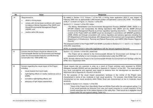
No. Issue Response<br />
14 Requirement to:<br />
• obtain a mining lease;<br />
• comply with mining lease conditions with respect<br />
to lodging a Mining Operations Plan (MOP) and<br />
Annual Environmental Management Report<br />
(AEMR); and<br />
• resolve native title issues.<br />
15 Concern that the Project should be referred to the<br />
Commonwealth Minister for Environment and Heritage<br />
under the Environmental Protection and Biodiversity<br />
Conservation Act, 1999 (EPBC Act).<br />
As stated in Section 1.2.3, Volume 1 <strong>of</strong> the EIS, a mining lease application (MLA 1) was lodged in<br />
February 2005 over an approximate 2,800 hectare portion <strong>of</strong> Exploration Licence (EL) 6169. The location<br />
<strong>of</strong> MLA 1 is shown on Figure 1-3, Volume 1 <strong>of</strong> the EIS.<br />
Section 5.1.1, Volume 1 <strong>of</strong> the EIS, states:<br />
“The Mining, Rehabilitation and Environmental Management Process (MREMP) (DMR, 2002b) is a<br />
DPI-MR initiative and incorporates the Mining Operations Plan (MOP) and the AEMR [Annual<br />
Environmental Management Report] as primary regulatory reporting documents… The structure and<br />
content <strong>of</strong> the Project MOP and AEMR would be developed in accordance with MREMP guidelines<br />
(DMR, 2002b) and through consultation with various regulatory and advisory agencies including the<br />
DPI [<strong>Department</strong> <strong>of</strong> Primary Industries], DEC [<strong>Department</strong> <strong>of</strong> Environment and Conservation], DIPNR<br />
[<strong>Department</strong> <strong>of</strong> Infrastructure, Planning and Natural Resources], and MWRC [Mid-Western Regional<br />
Council].”<br />
The proposed content <strong>of</strong> the Project MOP and AEMR is provided in Sections 5.1.1.1 and 5.1.1.2, Volume 1<br />
<strong>of</strong> the EIS, respectively.<br />
WCPL is currently involved in native title negotiations with the relevant registered claimants.<br />
Section 1.5.3, Volume 1 <strong>of</strong> the EIS, stated that:<br />
“The Project will be referred to the Commonwealth Minister for Environment and Heritage for an<br />
assessment <strong>of</strong> whether or not it includes a controlled action under the EPBC Act.”<br />
WCPL formally referred the Project to the Commonwealth Minister for Environment and Heritage under the<br />
EPBC Act in September 2005.<br />
16 Concern regarding the visual impact <strong>of</strong> the Project<br />
including:<br />
• visual impacts from local roads;<br />
• night-lighting effects on nearby residences and on<br />
wildlife;<br />
• cumulative night-lighting effects; and<br />
• adequacy <strong>of</strong> light impact assessment.<br />
Visual impacts that are expected to arise as a result <strong>of</strong> Project activities were assessed by EDAW<br />
Gillespies Australia (EDAW) and are described in Appendix N, Volume 5 <strong>of</strong> the EIS. The visual settings<br />
(e.g. local, sub-regional and regional) were based on distance from the development as described in<br />
Attachment NA <strong>of</strong> Appendix N, Volume 5 <strong>of</strong> the EIS.<br />
For the purposes <strong>of</strong> the visual impact assessment, landuses in the vicinity <strong>of</strong> the Project were<br />
characterised in terms <strong>of</strong> low, moderate or high visual sensitivity. For example, Ulan-Wollar Road was<br />
characterised as low visual sensitivity whilst Wollar Road was characterised as low to moderate visual<br />
sensitivity.<br />
As stated in Section 4.2.3, Volume 1 <strong>of</strong> the EIS:<br />
“Views <strong>of</strong> the Project from Ulan-Wollar Road and Wollar Road within the sub-regional setting (1 to<br />
5 km) would generally be obscured from view and would comprise to a small proportion <strong>of</strong> the<br />
overall viewscape due to the relative flatness <strong>of</strong> the valley floor. There would be a negligible visual<br />
impact within the sub-regional setting (Table 4-2). …<br />
WIL-03\2\2\ISSUES AND RESPONSES ALL TABLES.DOC Page 21 <strong>of</strong> 119


