Burnt Bridge Creek Trail map - City of Vancouver
Burnt Bridge Creek Trail map - City of Vancouver
Burnt Bridge Creek Trail map - City of Vancouver

Create successful ePaper yourself
Turn your PDF publications into a flip-book with our unique Google optimized e-Paper software.
NE Andresen Rd<br />
86th Ave<br />
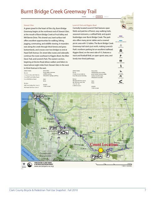
<strong>Burnt</strong> <strong>Bridge</strong> <strong>Creek</strong> Greenway <strong>Trail</strong><br />
8 miles<br />
EASY MODERATE DIFFICULT<br />
LA<br />
CENTER<br />
YACOLT/AMBOY<br />
Stewart Glen<br />
A green jewel in the heart <strong>of</strong> the city, <strong>Burnt</strong> <strong>Bridge</strong><br />
Greenway begins at the northwest end <strong>of</strong> Stewart Glen,<br />
at the mouth <strong>of</strong> <strong>Burnt</strong> <strong>Bridge</strong> <strong>Creek</strong> at Fruit Valley and<br />
NW Bernie Drive. This shared-use, hard-surface trail<br />
<strong>of</strong>fers excellent opportunities for walking, biking,<br />
jogging, commuting, and wildlife viewing. It meanders<br />
east along the creek through thick forests and grass<br />
bottomlands, and crosses over two bridges to end at<br />
Hazel Dell Avenue. On-street bike routes and sidewalks<br />
continue the route southeast to Kiggins Bowl, the Ellen<br />
Davis <strong>Trail</strong>, and Leverich Park. The eastern section,<br />
begining at Devine Road allows walkers and bikers to<br />
travel almost eight miles from Stewart Glen in the west<br />
to 92nd Avenue in the east.<br />
DIRECTIONS<br />
By car:<br />
I-5 exit 4; W on NE 78th St;<br />
S on NW Fruit Valley Road;<br />
E on NW BErnie Road<br />
By bus:<br />
NW Fruit Valley Rd.: Line 2;<br />
NE Hazel Dell Ave: Line 6<br />
FACILITIES<br />
Picnic tables, restroom,<br />
wildlife viewing,<br />
interpretive signage, parking<br />
FEES<br />
None<br />
HOURS<br />
7 A.M. to dusk<br />
Leverich Park and Kiggins Bowl<br />
Centrally located Leverich Park features open<br />
fields and patches <strong>of</strong> forest, easy walking trails,<br />
seasonal restrooms, a s<strong>of</strong>tball field, and quaint<br />
footbridges over <strong>Burnt</strong> <strong>Bridge</strong> <strong>Creek</strong>. The park<br />
also <strong>of</strong>fers many picnic tables and a covered<br />
picnic area with 12 tables. The <strong>Burnt</strong> <strong>Bridge</strong> <strong>Creek</strong><br />
Greenway trail starts just north, making Leverich<br />
Park’s northern parking lot an excellent trailhead.<br />
Kiggins Bowl, on the west side <strong>of</strong> I-5, features a<br />
track and football field, an open sports area, and<br />
lovely tree-lined pathways.<br />
DIRECTIONS<br />
By car:<br />
I-5 exit 2; E on E 39th St;<br />
N on NE Leverich Park Way<br />
By bus:<br />
NE Hazel Dell Ave; Line 6;<br />
NE 15th Ave: Lines 190,<br />
173, 157, 134<br />
E 39th St: Line 3<br />
FACILITIES<br />
S<strong>of</strong>tball field, picnic tables,<br />
picnic shelter, restroom, BBQ<br />
stands, horseshoe pits,<br />
wheelchair accessible<br />
FEES<br />
None<br />
HOURS<br />
7 A.M. to dusk<br />
RIDGEFIELD<br />
MULTI-USE PATH<br />
BIKE LANES AND SIDEWALKS<br />
TRAIL ACCESS<br />
STEEP SLOPES<br />
PARKING<br />
PUBLIC RESTROOMS<br />
SPORTS FIELDS<br />
PLAY AREA<br />
(RESERVABLE)<br />
PICNIC TABLES<br />
PICNIC SHELTER<br />
BATTLEGROUND<br />
CAMAS/<br />
WASHOUGAL<br />
<strong>Vancouver</strong><br />
Lake<br />
P<br />
Bernie Dr<br />
1.3mi<br />
Stewart<br />
Glen<br />
NE Hazel Dell Ave<br />
I-205<br />
Fruit Valley Road<br />
Kiggins<br />
Bowl<br />
1.2mi<br />
Columbia<br />
06/2010<br />
River<br />
W 39th St<br />
P<br />
Main St<br />
Downtown<br />
<strong>Vancouver</strong><br />
Esther<br />
Short Park<br />
Leverich<br />
Park<br />
VANCOUVER-CLARK PARKS<br />
& RECREATION DEPARTMENT<br />
www.vanclarkparks-rec.org/<br />
P<br />
I-5<br />
Fort <strong>Vancouver</strong> Way<br />
East Reserve<br />
1.4mi<br />
St<br />
Fort <strong>Vancouver</strong><br />
<strong>Vancouver</strong><br />
Johns Rd<br />
Water<br />
Works<br />
Park<br />
.5mi<br />
Fourth Plain Blvd<br />
E 18th St<br />
SR 500<br />
Nicolson Rd<br />
.7mi<br />
Count Location<br />
.4mi<br />
P<br />
.4mi<br />
Blandford Canyon<br />
Devine Rd<br />
.8mi<br />
P<br />
Meadowbrook<br />
North<br />
Burton Rd<br />
Meadowbrook<br />
Marsh<br />
1.0mi<br />
David Douglas<br />
Community<br />
Park<br />
Mill Plain Blvd<br />
19th Circle<br />
0 1/2 1 2 MILES<br />
1 INCH = 0.85 MILE<br />
Clark County Bicycle & Pedestrian <strong>Trail</strong> Use Snapshot : Fall 2010 7
<strong>Burnt</strong> <strong>Bridge</strong> <strong>Creek</strong> Greenway <strong>Trail</strong><br />
Count and Survey Findings<br />
Annual trail use on the Columbia River Renaissance <strong>Trail</strong> in 2010 was estimated to be 253,955, an increase from the<br />
previous two years. For the past three years, the <strong>Burnt</strong> <strong>Bridge</strong> <strong>Creek</strong> Greenway <strong>Trail</strong> has reported the fourth highest<br />
usage <strong>of</strong> all the six trails counted. <strong>Trail</strong> survey respondents represent approximately 17% <strong>of</strong> those counted. Of<br />
those who voluntarily completed user surveys, 97% responded they were using the trail for recreation/exercise/<br />
pleasure, and 3% said they were using the trail for going to/from work or school. The following charts and graphs<br />
represent the results <strong>of</strong> the count and surveys specific to the <strong>Burnt</strong> <strong>Bridge</strong> Greenway-Discovery <strong>Trail</strong>.<br />
Weather: Cloudy both days - considered poor<br />
Number and user description:<br />
Other*<br />
Bike<br />
Pedstrian<br />
0 20 40 60 80 100 120 140<br />
*Other may be skateboards, roller blades, etc.<br />
Gender:<br />
Female<br />
43%<br />
Male<br />
57%<br />
8 Clark County Bicycle & Pedestrian <strong>Trail</strong> Use Snapshot : Fall 2010
1. What best describes why you are out here today?<br />
Going to/from<br />
Work or School<br />
3%<br />
Pleasure,<br />
Exercising,<br />
Recreation<br />
97%<br />
2. What are you doing on the trail right now?<br />
Jogging<br />
20%<br />
Other<br />
3%<br />
Biking<br />
10%<br />
Walking<br />
67%<br />
Clark County Bicycle & Pedestrian <strong>Trail</strong> Use Snapshot : Fall 2010 9
3. Please check any other transportation modes in your trip today, including how you<br />
got to the trail.<br />
Walk or Bike<br />
Transit<br />
Carpool<br />
Car<br />
0 5 10 15 20 25<br />
4. Where did you start this trip? (nearest street intersection)<br />
5. Where will you end this trip? (if you will end where you started, give the furthest<br />
point reached)<br />
Incomplete Data for Q 4. & 5. See report p. 4 for explanation<br />
6. How do you rate the path on each <strong>of</strong> the following?<br />
Access points - connectivity<br />
Width <strong>of</strong> trail<br />
Crowding on trail<br />
Clean<br />
Condition <strong>of</strong> natural features/area<br />
Length <strong>of</strong> trail<br />
Safe<br />
Access for persons with disabilities<br />
Speed on trail<br />
Condition <strong>of</strong> trail surface<br />
Concerning safety<br />
Parking<br />
Concerning nature<br />
Directional signage/<strong>map</strong>s<br />
Trash cans<br />
Drinking fountains<br />
Restrooms<br />
Excellent<br />
Good<br />
Fair<br />
Poor<br />
Don't Know<br />
0% 20% 40% 60% 80% 100%<br />
10 Clark County Bicycle & Pedestrian <strong>Trail</strong> Use Snapshot : Fall 2010
7. Why are you using this trail instead <strong>of</strong> walking/riding elsewhere?<br />
Flat / level<br />
Scenic qualities<br />
Safer than using<br />
roads<br />
Direct/good<br />
connections<br />
Accessible/close<br />
0 5 10 15 20<br />
8. In the past month, how <strong>of</strong>ten have you used this trail?<br />
Daily<br />
11-20 times<br />
6-10 times<br />
0-5 times<br />
First Time<br />
0 2 4 6 8 10 12<br />
9. Please check the seasons in which you use the trail.<br />
Spring<br />
Winter<br />
Fall<br />
Summer<br />
0 5 10 15 20 25 30<br />
Clark County Bicycle & Pedestrian <strong>Trail</strong> Use Snapshot : Fall 2010 11
10. Home zip code?<br />
Zip Code Analysis: <strong>Burnt</strong> <strong>Bridge</strong> <strong>Creek</strong><br />
0 10<br />
Miles<br />
<strong>Burnt</strong> <strong>Bridge</strong> <strong>Creek</strong><br />
!<br />
¯<br />
Response Rates<br />
Low Medium High<br />
12 Clark County Bicycle & Pedestrian <strong>Trail</strong> Use Snapshot : Fall 2010
11. Your age?<br />
70+<br />
60-69<br />
50-59<br />
40-49<br />
30-39<br />
20-29<br />
14. Comments?<br />
• A great community resource<br />
• Awesome!<br />
• Bike people don’t give warning when approaching from behind<br />
• Bike speed can cause walker’s problems, break-ins at Devine Rd is a big problem.<br />
• Good job<br />
• Good survey<br />
• Great trail<br />
• Keep it up!<br />
• Keep rest rooms open all season<br />
• Longer to connect to Camas. Rest rooms available in winter<br />
• More trails, flat-ones, trim low branches in bike lanes on roads<br />
• Need more great trails like this one!<br />
• Some sections <strong>of</strong> the trail area little rough on the surface for some senior citizens<br />
• Thanks for the walking trail<br />
• Very enjoyable trail, scenic<br />
• Very good, safe<br />
14 Clark County Bicycle & Pedestrian <strong>Trail</strong> Use Snapshot : Fall 2010