Discovery Report - Ohio Department of Natural Resources
Discovery Report - Ohio Department of Natural Resources
Discovery Report - Ohio Department of Natural Resources

You also want an ePaper? Increase the reach of your titles
YUMPU automatically turns print PDFs into web optimized ePapers that Google loves.
• Educate the citizens <strong>of</strong> each county to increase awareness <strong>of</strong> flooding and where to<br />
seek safety during flood events<br />
• Provide adequate shelters where citizens can seek safety from severe weather and<br />
flooding<br />
• Improve the warning systems and radio communications throughout the county<br />
• Expedite the cleanup process through coordination and equipment acquisition<br />
• Update countywide NFIP maps<br />
• Purchase or flood pro<strong>of</strong> repetitive loss structures<br />
• Develop map <strong>of</strong> infrastructure concerns<br />
Some <strong>of</strong> the county’s/community’s HMPs included the locations and number <strong>of</strong> repetitive<br />
loss structures while other plans left this information out. This inconsistency in information<br />
holds true with the location and number <strong>of</strong> critical facilities found within the 1-percentannual-chance<br />
floodplain.<br />
Successful Mitigation Projects<br />
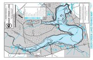
There have been two recent mitigation projects in the watershed. In 2006, North Royalton<br />
was awarded a grant from FEMA for the acquisition <strong>of</strong> four residential structural that were<br />
located in the floodplain <strong>of</strong> Baldwin Creek. Areas <strong>of</strong> the Baldwin Creek have eroded and<br />
been filled in by soil to the extent where there is no recognizable channel <strong>of</strong> water. The<br />
creek’s capacity and ability to drain and convey the flow <strong>of</strong> water has diminished. In 2010,<br />
Valley View was also awarded a pre-disaster mitigation grant to reduce future cost<br />
incurred from flood damages. This grant will allow thirteen homes to be elevated.<br />
Coordinated Needs Management Strategy (CNMS) and NFIP Mapping Study Needs<br />
Analysis <strong>of</strong> the CNMS data for the Cuyahoga Watershed is finished. Analyzed studies<br />
have been identified as “VALID” or “UNVERIFIED”. The current CNMS geospatial data<br />
is presented on the Final <strong>Discovery</strong> Map.<br />
Community Rating System (CRS)<br />
The Village <strong>of</strong> Orange and Medina County are the only communities in the Cuyahoga<br />
Watershed that participate in the CRS program.<br />
Levees<br />
No levees have been identified within the Cuyahoga watershed within FEMAs Mid-Term<br />
Levee Inventory database<br />
Floodplain Management/Community Assistance Visits<br />
FEMA uses a number <strong>of</strong> key tools to determine a community’s compliance with the<br />
minimum regulations <strong>of</strong> the National Flood Insurance Program. Among them are<br />
Community Assistance Visits (CAVs), the Letter <strong>of</strong> Map Change (LOMC) process, and<br />
Submit-for-Rates. These tools help assess a community’s implementation <strong>of</strong> their Flood<br />
Damage Reduction Regulations and identify any floodplain management deficiencies and<br />
violations. The CAV is a visit to a community by a FEMA staff member or staff <strong>of</strong> a state<br />
11<br />
Cuyahoga Watershed <strong>Discovery</strong> <strong>Report</strong>, November 2011