California's Central Coast Marine Protected Areas - California Sea ...
California's Central Coast Marine Protected Areas - California Sea ...
California's Central Coast Marine Protected Areas - California Sea ...

You also want an ePaper? Increase the reach of your titles
YUMPU automatically turns print PDFs into web optimized ePapers that Google loves.
Baseline Data Collection for<br />
Rocky Intertidal MPAs in the <strong>Central</strong> <strong>Coast</strong><br />
R/MPA-2 June 2007-May 2008<br />
Peter Raimondi, UC Santa Cruz<br />
Summary<br />
In this project, scientists surveyed rocky intertidal areas (tide pools)<br />
within the central coast marine protected areas (MPAs) and associated<br />
reference sites.<br />
They coordinated their sampling with the two largest rocky intertidal<br />
monitoring programs in the state—Partnership for Interdisciplinary<br />
Studies of <strong>Coast</strong>al Oceans (PISCO) and Multi-Agency Rocky Intertidal<br />
Network (MARINe). The main goal was to document community<br />
structure of target assemblages (e.g., mussels, barnacles and surfgrass),<br />
as well as to quantify abundances and sizes of key species<br />
(e.g., abalone, owl limpets and seastars). They also recorded<br />
biodiversity hotspots and species-habitat associations. With this<br />
baseline data, scientists may be able to detect changes in intertidal<br />
areas associated with the MPAs.<br />
“There is a great need to capture the diversity of sites and to map<br />
it in 3D,” says the project’s leader, professor Peter Ramondi of the<br />
Department of Ecology and Evolutionary Biology at UC Santa Cruz.<br />
“The intertidal is where most people interact with the shoreline,” he<br />
says. “These areas are very sensitive to trampling, collecting, development<br />
and agricultural and urban runoff.”<br />
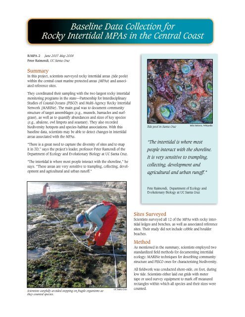
Mila Zinkova, Wikipedia<br />
Tide pool in Santa Cruz<br />
“The intertidal is where most<br />
people interact with the shoreline.<br />
It is very sensitive to trampling,<br />
collecting, development and<br />
agricultural and urban runoff.”<br />
Pete Raimondi, Department of Ecology and<br />
Evolutionary Biology at UC Santa Cruz<br />
Scientists carefully avoided stepping on fragile organisms as<br />
they counted species.<br />
UC Santa Cruz<br />
Sites Surveyed<br />
Scientists surveyed all 12 of the MPAs with rocky intertidal<br />
ledges and benches, as well as associated reference<br />
sites. Their study did not include cobble and boulder<br />
beaches.<br />
Method<br />
As mentioned in the summary, scientists employed two<br />
standardized field methods for documenting intertidal<br />
ecology: MARINe techniques for describing community<br />
structure and PISCO ones for characterizing biodiversity.<br />
All fieldwork was conducted shore-side, on foot, during<br />
low tide. Scientists either laid out grids with meter<br />
tape or used survey equipment to mark off measured<br />
rectangles within which all species and their sizes were<br />
counted.