Lake George Watershed Lake Steward Program End of Season ...
Lake George Watershed Lake Steward Program End of Season ...
Lake George Watershed Lake Steward Program End of Season ...

You also want an ePaper? Increase the reach of your titles
YUMPU automatically turns print PDFs into web optimized ePapers that Google loves.
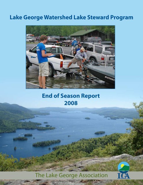
<strong>Lake</strong> <strong>George</strong> <strong>Watershed</strong> <strong>Lake</strong> <strong>Steward</strong> <strong>Program</strong><br />
<strong>End</strong> <strong>of</strong> <strong>Season</strong> Report<br />
2008<br />
The <strong>Lake</strong> <strong>George</strong> Association
This program was funded through the <strong>Lake</strong> <strong>George</strong> <strong>Watershed</strong> Conference<br />
(LGWC) and the <strong>Lake</strong> <strong>George</strong> Association (LGA). Funding from the LGA is<br />
generously provided by the Helen V. Froelich Foundation. Funding from<br />
the LGWC is provided by the NYS Department <strong>of</strong> State with funds provided<br />
under Title 11 <strong>of</strong> the Environmental Protection Fund.
<strong>Lake</strong> <strong>George</strong> <strong>Watershed</strong> <strong>Lake</strong> <strong>Steward</strong> <strong>Program</strong><br />
<strong>End</strong> <strong>of</strong> <strong>Season</strong> Report 2008<br />
by Emily DeBolt<br />
<strong>Program</strong> Coordinator, <strong>Lake</strong> <strong>George</strong> <strong>Watershed</strong> <strong>Lake</strong> <strong>Steward</strong> <strong>Program</strong><br />
Contributing writers:<br />
Justin Arzberger, Karlie Donlon, Lauren Ellmers, Jason Smith,<br />
Ben Strong and Samantha Zuhlke
The <strong>Lake</strong> <strong>George</strong> <strong>Watershed</strong> <strong>Lake</strong> <strong>Steward</strong> <strong>Program</strong> would<br />
like to say thank you to its many supporters. Without their<br />
contributions and commitment to protecting <strong>Lake</strong> <strong>George</strong>, the<br />
program would not have been successful.<br />
Baldwin, Joan, Norowal Marina<br />
Belden, Dan, Town <strong>of</strong> Hague Supervisor<br />
Bennett, Linda, Norowal Marina<br />
Blanchard, Wayne, NYS DEC<br />
Bove, Ann, VTDEC<br />
Cusano, Mike, New York Bass Federation<br />
Decker, David, <strong>Lake</strong> <strong>George</strong> <strong>Watershed</strong> Conference<br />
DeGoosh, Katie, RI DEM<br />
Demung, Leo, NYS DEC<br />
Eichler, Larry, Darrin Fresh Water Institute<br />
Goehle, Michael, USFWS<br />
Hall, Tom, NYS DEC<br />
Holmlund, Eric, Adirondack <strong>Watershed</strong> Institute<br />
King, Maria, NYS DEC<br />
Kishbaugh, Scott, NYS DEC<br />
Kurth, Emily, NYS DEC<br />
Leeson, Hope, Rhode Island Natural History Survey<br />
Levy, Dan, NYS DEC<br />
Lowe, Betsy, NYS DEC<br />
Modley, Meg, <strong>Lake</strong> Champlain Basin <strong>Program</strong><br />
Nierzwicki-Bauer, Sandra, Darrin Fresh Water Institute<br />
Parillo, Scott, Dunham’s Bay Marina<br />
Rawson, Bud, NYS DEC<br />
Raymond, Roberta, Island View Marina<br />
Reeps, Roslyn, CAES IAPP<br />
Robinson, Michelle, MA DCR<br />
Rourke, Daniel, NYS DEC<br />
Smagula, Amy, NH DES<br />
Smith, Hilary, Adirondack Park Invasive Plant <strong>Program</strong><br />
Starinchak, Joe, USFWS<br />
White, Mike, <strong>Lake</strong> <strong>George</strong> Park Commission<br />
Zollweg, Emily, NYS DEC<br />
The <strong>Lake</strong> <strong>George</strong> Association Staff<br />
All members <strong>of</strong> the <strong>Lake</strong> <strong>George</strong> <strong>Watershed</strong> Conference Invasive Species Task Force<br />
Cover photo: <strong>Lake</strong> <strong>George</strong> from First Peak, Samantha Zuhlke.<br />
Inside photos by Emily DeBolt, Ben Strong and Samantha Zuhlke (unless otherwise noted).<br />
Maps by Randy Rath, Project Manager and GIS Specialist, <strong>Lake</strong> <strong>George</strong> Association.
Table <strong>of</strong> Contents<br />
Abstract ................................................................................<br />
Introduction and Background .............................................<br />
Staff Biographies .................................................................<br />
Key Findings .........................................................................<br />
<strong>Lake</strong> <strong>Steward</strong> Launch Locations<br />
Norowal Marina ...........................................................<br />
Mossy Point Boat Launch ...........................................<br />
Dunham’s Bay Marina .................................................<br />
Hague Town Launch ....................................................<br />
Rogers Rock Campground ..........................................<br />
Northwest Bay Cartop Launch ...................................<br />
Island View Marina ......................................................<br />
Fishing Tournament Outreach ............................................<br />
Educational Outreach Activities .........................................<br />
Terrestrial Invasive Species ................................................<br />
Recommendations and Future Considerations .................<br />
Appendices ...........................................................................<br />
A: Data Collection Sheet .....................................................<br />
B: Map <strong>of</strong> Launch Locations ...............................................<br />
C: Map <strong>of</strong> Zebra Mussel Locations in LG ...........................<br />
D: Map <strong>of</strong> Eurasian Watermilfoil Locations in LG ..............<br />
E: List <strong>of</strong> All Previously Visited Waterbodies .....................<br />
F: List <strong>of</strong> All Previously Visited Waterbodies by State ......<br />
G: List <strong>of</strong> All Invasive Species Removed from Boats .........<br />
H: List <strong>of</strong> All Specimens Removed ......................................<br />
I: List <strong>of</strong> All Invasives Found by Weekday ..........................<br />
J: Scientific and Common Names <strong>of</strong> Invasive Species ......<br />
K: Invasive Species in Previously Visited Waterbodies .....<br />
L: <strong>Steward</strong> Materials and Supplies .....................................<br />
1<br />
3<br />
7<br />
9<br />
21<br />
31<br />
39<br />
47<br />
53<br />
59<br />
63<br />
67<br />
71<br />
73<br />
75<br />
80<br />
81<br />
82<br />
83<br />
84<br />
85<br />
87<br />
91<br />
93<br />
96<br />
98<br />
99<br />
101
P.O. Box 408<br />
2392 State Route 9N<br />
<strong>Lake</strong> <strong>George</strong>, NY 12845<br />
Phone: 518-668-3558<br />
Email: info@lakegeorgeassociation.org<br />
www.lakegeorgeassociation.org
DRAFT<br />
Abstract<br />
<strong>Lake</strong> <strong>George</strong> is located in northern New York, in the southeastern corner <strong>of</strong> the Adirondack<br />
Park. The lake is rated as AA-Special by the State <strong>of</strong> New York, meaning its best usage is as<br />
a drinking water supply. However the lake’s water quality is increasingly being threatened by<br />
human activities and pressures around the lake. One <strong>of</strong> the many threats to the lake’s water<br />
quality is the introduction <strong>of</strong> aquatic invasive species. To address this threat, an aquatic<br />
invasive species spread prevention and education program was started on <strong>Lake</strong> <strong>George</strong> in<br />
2006. The goal <strong>of</strong> the program is to prevent new introductions <strong>of</strong> invasive species into <strong>Lake</strong><br />
<strong>George</strong> and to educate boaters. The <strong>Lake</strong> <strong>Steward</strong>s inspect boats at launches and collect<br />
quantitative data about the number <strong>of</strong> boats and last waterbody <strong>of</strong> boats entering <strong>Lake</strong><br />
<strong>George</strong>. Such data can help determine the pathways <strong>of</strong> spread for aquatic invasive species<br />
between other regional waterways and <strong>Lake</strong> <strong>George</strong>.<br />
The <strong>Lake</strong> <strong>Steward</strong>s visually inspected 2,984 boats over the summer <strong>of</strong> 2008. Boats had<br />
previously been in 159 different waterbodies in 19 different states before coming to <strong>Lake</strong><br />
<strong>George</strong>. <strong>Lake</strong> <strong>George</strong> itself was the most common previously visited body <strong>of</strong> water at 1,770<br />
boats. After that, the Hudson River was the most common, with 89 boats. New York was<br />
the state with the most waterbodies mentioned as previous boating locations at 57, while<br />
Massachusetts came in second with 19 and New Jersey third at 18. A total <strong>of</strong> 113 samples<br />
were removed from 5 <strong>of</strong> the 7 launches <strong>Lake</strong> <strong>Steward</strong>s were stationed at. Of the 113<br />
samples, a total <strong>of</strong> 61 specimens <strong>of</strong> invasive species were removed from boats, making 54%<br />
<strong>of</strong> all samples removed from boats invasive. 4 different species <strong>of</strong> invasives were found<br />
overall: Eurasian watermilfoil, curly-leaf pondweed, water chestnut, and zebra mussels. 9<br />
waterbodies were identified as possibly providing the source material <strong>of</strong> invasive species that<br />
hitchhiked on boats to launches at <strong>Lake</strong> <strong>George</strong>.<br />
<strong>Lake</strong> <strong>George</strong> <strong>Watershed</strong> <strong>Lake</strong> <strong>Steward</strong> <strong>Program</strong> <strong>End</strong> <strong>of</strong> <strong>Season</strong> Report 2008
DRAFT<br />
<strong>Lake</strong> <strong>George</strong> <strong>Watershed</strong> <strong>Lake</strong> <strong>Steward</strong> <strong>Program</strong> <strong>End</strong> <strong>of</strong> <strong>Season</strong> Report 2008
DRAFT<br />
Introduction and Background<br />
About the <strong>Program</strong> Sponsors<br />
The <strong>Lake</strong> <strong>George</strong> Association (LGA)<br />
The LGA’s mission statement is “Working together to protect, conserve and improve the<br />
beauty and quality <strong>of</strong> the <strong>Lake</strong> <strong>George</strong> Basin.” Since its inception in 1885, the LGA has<br />
evolved to incorporate and address the changing needs <strong>of</strong> the <strong>Lake</strong> <strong>George</strong> environment.<br />
The LGA advocates a reasoned, balanced approach to the management and conservation<br />
<strong>of</strong> the <strong>Lake</strong> <strong>George</strong> watershed through education, remediation, advocacy and broad-based<br />
community involvement. The goal is to ensure the long-term stability <strong>of</strong> the lake’s exceptional<br />
water quality and the economic viability <strong>of</strong> the region.<br />
The <strong>Lake</strong> <strong>George</strong> <strong>Watershed</strong> Conference (LGWC)<br />
Formed in 1999, the LGWC is a coalition made up <strong>of</strong> the municipalities, counties, state<br />
agencies, and non-pr<strong>of</strong>it organizations involved in protecting <strong>Lake</strong> <strong>George</strong>. The purpose <strong>of</strong><br />
the LGWC is to provide a forum to identify the priorities for protecting the lake’s water quality<br />
and to coordinate the proactive use <strong>of</strong> resources to accomplish this mission. The Conference<br />
is chaired by the Secretary <strong>of</strong> State, the Honorable Lorraine Cortes-Vazquez.<br />
Introduction<br />
2008 was the third and final year <strong>of</strong> a three year pilot project lake steward program on <strong>Lake</strong><br />
<strong>George</strong>. The program was initiated in 2006 by the <strong>Lake</strong> <strong>George</strong> <strong>Watershed</strong> Conference. One<br />
<strong>of</strong> the many threats to the lake’s water quality is the introduction <strong>of</strong> aquatic invasive species.<br />
The goal <strong>of</strong> the program is to help prevent new introductions <strong>of</strong> invasive species into <strong>Lake</strong><br />
<strong>George</strong> by inspecting boats at launches and to collect quantitative data about the number<br />
and last location <strong>of</strong> boats entering <strong>Lake</strong> <strong>George</strong> and the possible pathways <strong>of</strong> spread for<br />
aquatic invasive species between other regional waterways and <strong>Lake</strong> <strong>George</strong>.<br />
<strong>Lake</strong> <strong>George</strong> <strong>Watershed</strong> <strong>Lake</strong> <strong>Steward</strong> <strong>Program</strong> <strong>End</strong> <strong>of</strong> <strong>Season</strong> Report 2008
DRAFT<br />
Invasive Species Background<br />
Invasive species are threatening ecological communities and impacting the economy<br />
nation-wide. They are estimated to cost the United States more than $100 billion annually<br />
in environmental losses and damages. Invasive species are one <strong>of</strong> the greatest threats to<br />
biodiversity, second only to direct habitat loss in many locations. Within the Adirondack<br />
Park, which includes part <strong>of</strong> the <strong>Lake</strong> Champlain Basin, invasive species are the number one<br />
threat to biodiversity. Aquatic invasive species disrupt aquatic food webs and habitats, outcompeting<br />
native species and altering the ecological function <strong>of</strong> lakes and rivers. Species<br />
such as zebra mussels clog water intake pipes, attach to dock pilings and the underside<br />
<strong>of</strong> boats, and litter beaches with sharp shells that cut bare feet. Dense mats <strong>of</strong> Eurasian<br />
watermilfoil on the surface make boating, swimming, and other recreation difficult.<br />
<strong>Lake</strong> <strong>George</strong> is rated as AA-Special by the State <strong>of</strong> New York, meaning its best usage is as<br />
a drinking water supply. However the lake’s water quality is increasingly being threatened<br />
by the introduction <strong>of</strong> invasive species. Eurasian watermilfoil was first documented in North<br />
America in 1942 in the District <strong>of</strong> Columbia. By 1985 it has made its way north, and was<br />
identified in <strong>Lake</strong> <strong>George</strong>. Zebra mussels were first discovered in <strong>Lake</strong> St. Clair in 1988 and<br />
were found in <strong>Lake</strong> <strong>George</strong> in 1999.<br />
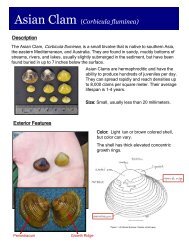
Zebra mussel<br />
Curly-leaf Pondweed<br />
Eurasian watermilfoil<br />
To date, <strong>Lake</strong> <strong>George</strong> has been infested with three known invasive species: Eurasian<br />
watermilfoil (Myriophyllum spicatum), curly-leaf pondweed (Potamogeton crispus), and zebra<br />
mussels (Dreissena polymorpha). Nearby, <strong>Lake</strong> Champlain has 48 invasive species, the St.<br />
Lawrence River has 87, the Hudson River 91, and the Great <strong>Lake</strong>s has 183 documented<br />
invasive species. These bodies <strong>of</strong> water surround <strong>Lake</strong> <strong>George</strong> on all sides, and boats can<br />
easily be trailered from one to the next.<br />
Hundreds <strong>of</strong> thousands <strong>of</strong> dollars have already been spent by local entities to manage<br />
the Eurasian watermilfoil and the zebra mussels in <strong>Lake</strong> <strong>George</strong>. The <strong>Lake</strong> <strong>George</strong> Park<br />
Commission is currently managing Eurasian watermilfoil. Their 2007 management report<br />
states that there are 160 identified locations <strong>of</strong> Eurasian watermilfoil in the lake “with high<br />
concentrations near human population centers and boat-use areas”. Over 19,000 plants<br />
were removed by hand harvesting and over 170,000 square feet <strong>of</strong> benthic barrier installed<br />
in 2007 (report available online at http://www.lgpc.state.ny.us/PDF/LG2007.pdf).<br />
Zebra mussels were first discovered in the lake in December<br />
<strong>of</strong> 1999. After ice out in April <strong>of</strong> 2000, scuba divers from the<br />
Darrin Fresh Water Institute (DFWI) and Bateaux Below removed<br />
over 19,000 zebra mussels from around the docks at a site near<br />
<strong>Lake</strong> <strong>George</strong> Village. Since this initial finding, 6 more locations<br />
have been found, although none nearly as large as the first<br />
colony. As <strong>of</strong> the end <strong>of</strong> the 2007 season, 24,624 mussels had<br />
been removed from the lake by divers. 5 <strong>of</strong> the 7 sites are boat<br />
launches/marinas and the other two sites are docks.<br />
Zebra mussels at DFWI.<br />
<strong>Lake</strong> <strong>George</strong> <strong>Watershed</strong> <strong>Lake</strong> <strong>Steward</strong> <strong>Program</strong> <strong>End</strong> <strong>of</strong> <strong>Season</strong> Report 2008
DRAFT<br />
In the last few years, as understanding <strong>of</strong> invasive<br />
species and their consequences has increased, efforts<br />
have increased to stop or slow their spread. For<br />
aquatic invasives, boats and trailers moving between<br />
waterways seem to be a clear mode <strong>of</strong> transportation<br />
for invasive and native species alike. Based on the<br />
locations <strong>of</strong> the highest concentrations <strong>of</strong> milfoil being<br />
at boat-use areas and zebra mussels being found<br />
mainly at boat launches, the connection between boats<br />
and the introduction and movement <strong>of</strong> invasive species<br />
in <strong>Lake</strong> <strong>George</strong> is clear.<br />
<strong>Lake</strong> <strong>George</strong> and its <strong>Watershed</strong><br />
Bits <strong>of</strong> broken plants at the town<br />
launch entrance in Hague.<br />
<strong>Lake</strong> <strong>George</strong> is located in northern New York, in the southeastern corner <strong>of</strong> the Adirondack<br />
Park. It is a 32 mile long, oligotrophic lake formed by earthquakes and glaciers. The lake is<br />
classified as Class AA-Special by New York State, which means one <strong>of</strong> its best usages is as a<br />
drinking water supply. The lake is used as drinking water by many people around the lake.<br />
The maximum depth <strong>of</strong> the lake is just under<br />
200 feet deep, with an average depth <strong>of</strong><br />
about 70 feet. The widest part <strong>of</strong> the lake is<br />
about 2 miles across, while the average width<br />
is 1.33 miles. There are over 170 islands<br />
dotting the lake’s surface. <strong>Lake</strong> <strong>George</strong> flows<br />
from the south to the north and drops 226<br />
feet into <strong>Lake</strong> Champlain through the LaChute<br />
River in Ticonderoga.<br />
Streams provide the lake with just over<br />
half <strong>of</strong> its water; the rest comes from<br />
precipitation directly on the lake’s surface and<br />
groundwater. There are over 100 streams<br />
in the watershed, with just 8 major streams<br />
providing about 2/3 <strong>of</strong> the total stream flow<br />
going into the lake.<br />
A watershed is an area <strong>of</strong> land that drains into<br />
a waterbody. The <strong>Lake</strong> <strong>George</strong> watershed is<br />
233 square miles, which is about five times<br />
the area <strong>of</strong> the lake’s surface.<br />
The lake’s elevation is 320 feet above sea<br />
level, while the highest point in the watershed<br />
is the peak <strong>of</strong> Black Mtn. at 2,646 feet.<br />
<strong>Lake</strong> <strong>George</strong> <strong>Watershed</strong> <strong>Lake</strong> <strong>Steward</strong> <strong>Program</strong> <strong>End</strong> <strong>of</strong> <strong>Season</strong> Report 2008
<strong>Program</strong> Description<br />
DRAFT<br />
The <strong>Lake</strong> <strong>George</strong> <strong>Watershed</strong> <strong>Lake</strong> <strong>Steward</strong> <strong>Program</strong> is an aquatic invasive species spread<br />
prevention and education program on <strong>Lake</strong> <strong>George</strong>. <strong>Lake</strong> <strong>Steward</strong>s are hired to work at<br />
marinas and boat launches during the summer. <strong>Lake</strong> <strong>George</strong> is a large lake, with around<br />
20 marinas, and various yacht clubs, public launches, and many hotels which let customers<br />
launch boats. <strong>Lake</strong> <strong>Steward</strong>s cannot cover every entry to the lake at all times. However,<br />
they can work at some <strong>of</strong> the high traffic launches and help prevent introductions at those<br />
locations, as well as help spread awareness. The <strong>Lake</strong> <strong>Steward</strong>s provide boaters with<br />
educational information about the threats <strong>of</strong> aquatic invasive species that are ecologically<br />
and economically harmful to the waters <strong>of</strong> <strong>Lake</strong> <strong>George</strong> and other waterways. <strong>Steward</strong>s help<br />
stop the introduction and transport <strong>of</strong> invasive species via boats and trailers by conducting<br />
visual inspections <strong>of</strong> boats and removing and identifying any plant or animal material found.<br />
<strong>Steward</strong>s also interview boaters to find out which body <strong>of</strong> water their boat was last in and<br />
if they have taken any spread prevention steps before arriving to launch. The <strong>Lake</strong> <strong>Steward</strong><br />
<strong>Program</strong> is a crucial step in protecting the water quality <strong>of</strong> <strong>Lake</strong> <strong>George</strong> and preventing the<br />
spread <strong>of</strong> invasive species between waterbodies throughout the <strong>Lake</strong> Champlain Basin and<br />
the Northeast.<br />
Staff and Training<br />
4 <strong>Lake</strong> <strong>Steward</strong>s were hired for the summer <strong>of</strong> 2008 as well as 1 Assistant Coordinator.<br />
Since the <strong>Program</strong> Coordinator had other work duties besides the <strong>Lake</strong> <strong>Steward</strong> <strong>Program</strong>,<br />
once the <strong>Lake</strong> <strong>Steward</strong>s were trained and working, the Assistant Coordinator oversaw their<br />
daily activities and was their key point <strong>of</strong> contact. Bi-weekly staff meetings allowed for<br />
constant communication and adjustments throughout the season as needed.<br />
Training began in mid-May with 2 days at Paul Smith’s College. We joined the Adirondack<br />
<strong>Watershed</strong> Institute’s training for their stewards. The <strong>Lake</strong> Champlain Basin <strong>Program</strong><br />
(LCBP) stewards also come for a day <strong>of</strong> joint training as well. All the stewards had a chance<br />
to meet stewards from other programs and find out about those programs. The stewards<br />
learned about interpretation techniques, types <strong>of</strong> boats, invasive plant identification, and<br />
other related topics. Staff from the LCBP, Adirondack Park Invasive Plant <strong>Program</strong>, NYS<br />
Department <strong>of</strong> Environmental Conservation, Adirondack Park Agency and Paul Smith’s<br />
College was on hand to cover a variety <strong>of</strong> topics for training.<br />
Once back in <strong>Lake</strong> <strong>George</strong>, training continued at the LGA for the rest <strong>of</strong> the week. The<br />
stewards learned specifics about <strong>Lake</strong> <strong>George</strong> and the invasives found in the lake, as well<br />
as the lay <strong>of</strong> the land. Staff from NYS DEC, the Darrin Fresh Water Institute and the <strong>Lake</strong><br />
<strong>George</strong> Park Commission helped out by covering various topics with the stewards.<br />
The stewards started work on Memorial Day weekend. They worked in pairs for the first 2<br />
weeks until they were comfortable, then they were split up and worked alone for the rest <strong>of</strong><br />
the season.<br />
<strong>Lake</strong> <strong>George</strong> <strong>Watershed</strong> <strong>Lake</strong> <strong>Steward</strong> <strong>Program</strong> <strong>End</strong> <strong>of</strong> <strong>Season</strong> Report 2008
DRAFT<br />
Staff Biographies<br />
Emily DeBolt<br />
<strong>Program</strong> Coordinator<br />
Emily is the Education and Outreach Coordinator for the <strong>Lake</strong><br />
<strong>George</strong> Association (LGA). She is active in the <strong>Lake</strong> <strong>George</strong><br />
<strong>Watershed</strong> Conference’s Invasive Species Task Force and<br />
the Adirondack Park Invasive Plant <strong>Program</strong>. She provides<br />
education to schools and the public about invasive species and<br />
water quality, as well as other <strong>Lake</strong> <strong>George</strong>-related topics. She<br />
joined the LGA in 2006 with a Bachelors degree from Cornell<br />
University and a Masters in Environmental Interpretation from<br />
SUNY-ESF.<br />
Benjamin Strong<br />
Assistant Coordinator<br />
Ben is a SUNY, University at Albany Senior majoring in Political<br />
Science and a former member <strong>of</strong> the United States Coast<br />
Guard. Having grown up in <strong>Lake</strong> <strong>George</strong>, Ben has a strong<br />
appreciation <strong>of</strong> the natural landscape and hopes to pursue a<br />
career in environmental protection.<br />
Justin Arzberger<br />
<strong>Lake</strong> <strong>Steward</strong><br />
Justin is from Ticonderoga, New York, and currently attends The<br />
University <strong>of</strong> Vermont where he hopes to attain his Bachelors<br />
degree in Environmental Studies in 2010. Growing up in the<br />
Adirondacks, Justin learned to appreciate the beauty and<br />
pristine nature <strong>of</strong> the land around us. By becoming a <strong>Lake</strong><br />
<strong>Steward</strong> he has learned more about the lake and invasive<br />
species as a whole.<br />
Karlie Donlon<br />
<strong>Lake</strong> <strong>Steward</strong><br />
Karlie, originally from Rochester, NY has completed an Associate<br />
in Science. She is currently in her last year at SUNY College <strong>of</strong><br />
Environmental Science and Forestry, completing her Bachelor <strong>of</strong><br />
Landscape Architecture. She will be taking a semester abroad in<br />
New Zealand, studying the enclosures and habitats <strong>of</strong> Zoos and<br />
Nature Preserves. With her love a natural areas she is also very<br />
interested in preserving the Adirondacks for the future.<br />
<strong>Lake</strong> <strong>George</strong> <strong>Watershed</strong> <strong>Lake</strong> <strong>Steward</strong> <strong>Program</strong> <strong>End</strong> <strong>of</strong> <strong>Season</strong> Report 2008
DRAFT<br />
Lauren Ellmers<br />
<strong>Lake</strong> <strong>Steward</strong><br />
A Fort Edward local, Lauren is a student at Hobart and William<br />
Smith College. After college, she plans to have a career in<br />
Environmental Regulations and help to protect the same<br />
Adirondack Park she grew up and enjoys spending time in.<br />
Volunteering to help clean up the Ohio River, she experienced<br />
the importance <strong>of</strong> clean waters and decided to help keep <strong>Lake</strong><br />
<strong>George</strong> pristine.<br />
Jason Smith<br />
<strong>Lake</strong> <strong>Steward</strong><br />
From Queensbury, New York, Jason is a student at Fredonia<br />
State University earning a degree in Environmental Science<br />
with concentrations in Limnology and Geographic Information<br />
Systems (GIS). As a resident <strong>of</strong> the <strong>Lake</strong> <strong>George</strong> area and<br />
frequent user <strong>of</strong> the lake and its watershed he has taken an<br />
interest in the impacts <strong>of</strong> recreation, specifically boating, on<br />
<strong>Lake</strong> <strong>George</strong>.<br />
Samantha Zuhlke<br />
<strong>Lake</strong> <strong>Steward</strong> Alternate<br />
In her second summer as the LGA’s Education and Outreach<br />
Intern, Samantha Zuhlke was the <strong>Lake</strong> <strong>Steward</strong> Alternate for the<br />
2008 season. After training with the stewards, she spent most<br />
<strong>of</strong> the summer fulfilling other duties but was able to make it to<br />
the launches on occasion. She is a Geography major and will be<br />
a junior at Colgate University in Hamilton, NY this fall.<br />
Justin Goodwin<br />
<strong>Lake</strong> <strong>Steward</strong> Volunteer<br />
For several weeks in July Justin volunteered at the Norowal<br />
Marina Launch Site to complete community service hours for<br />
school. Justin is from Texas where he attends high school at<br />
<strong>Lake</strong> Travis High School in South Austin.<br />
<strong>Lake</strong> <strong>George</strong> <strong>Watershed</strong> <strong>Lake</strong> <strong>Steward</strong> <strong>Program</strong> <strong>End</strong> <strong>of</strong> <strong>Season</strong> Report 2008
DRAFT<br />
Key Findings<br />
Number <strong>of</strong> Boats<br />
The <strong>Lake</strong> <strong>Steward</strong>s visually inspected 2984 boats<br />
over the summer. 1264 boats were inspected<br />
at Norowal Marina, 949 boats at Mossy Point<br />
Boat Launch, 437 at Dunham’s Bay Marina, 152<br />
at the Hague Town Launch, 126 at Rogers Rock<br />
Campground Launch, 31 at Northwest Bay Cartop<br />
Launch, and 25 at Island View Marina. While some<br />
launches were much busier than others, the <strong>Lake</strong><br />
<strong>Steward</strong>s spent different amounts <strong>of</strong> time at different<br />
launches, so the total number <strong>of</strong> boats inspected<br />
is not necessarily an accurate measure <strong>of</strong> overall<br />
launch activity.<br />
The <strong>Lake</strong> <strong>Steward</strong>s worked between Memorial Day in May and mid-August. A steward was<br />
at Norowal Marina for 48 days during the summer, 49 days at Mossy Point, 37 days at<br />
Dunham’s Bay, 9 days in Hague, 8 days at Rogers Rock, 2 days at Northwest Bay, and 5 days<br />
at Island View Marina. By calculating the average boats launched by day at each location,<br />
we can get a better idea <strong>of</strong> the traffic at the various launches (figure 2).<br />
Avg. # boats inspected/day<br />
3 0<br />
2 5<br />
2 0<br />
1 5<br />
1 0<br />
5<br />
0<br />
Average Boats Inspected By Day at Each Launch<br />
N or o w a l<br />
26<br />
M o ssy Po in t<br />
19<br />
D un h m as B ay<br />
12<br />
17 16 16<br />
<strong>Lake</strong> <strong>George</strong> <strong>Watershed</strong> <strong>Lake</strong> <strong>Steward</strong> <strong>Program</strong> <strong>End</strong> <strong>of</strong> <strong>Season</strong> Report 2008<br />
H ag u e<br />
R og e r s R ock<br />
Launch<br />
# boats<br />
Norowal Marina 1264<br />
Mossy Point 949<br />
Dunham’s Bay 437<br />
Hague 152<br />
Rogers Rock 126<br />
Northwest Bay 31<br />
Island View 25<br />
TOTAL 2964<br />
Figure 1: Summary <strong>of</strong> boats inspected at<br />
each launch site.<br />
N or th w e st B a y<br />
Isla n d V ie w<br />
Launch Location<br />
Figure 2: Average # <strong>of</strong> boats inspected by <strong>Lake</strong> <strong>Steward</strong>s at the 7 launches.<br />
5
DRAFT<br />
Norowal Marina and Mossy Point were the launches with the highest rate <strong>of</strong> traffic. <strong>Steward</strong>s<br />
had been located at these two marinas for the past two years, for this very reason. However,<br />
this year Dunham’s Bay was added on as a third major marina location. We thought it would<br />
have a similarly high traffic level. Based on these numbers, it actually appears to be the<br />
second slowest launch location. These results are based on the assumption that the <strong>Lake</strong><br />
<strong>Steward</strong> spent the same amount <strong>of</strong> time, 8 hours, each day at each location. This is most<br />
likely not the case, as weather and occasional personal conflicts would sometimes affect the<br />
number <strong>of</strong> hours spent at a location. However, most <strong>of</strong> the time the <strong>Lake</strong> <strong>Steward</strong>s were at a<br />
launch for 8 hours each day.<br />
Time <strong>of</strong> year could also affect these results, especially for the launches that the <strong>Lake</strong><br />
<strong>Steward</strong>s spent only a few days at. Some launches could be busy in July and not in August,<br />
while it could be the opposite for others. There is no way to correct for such seasonality in<br />
this data. We have to rely on local knowledge and coordination with marina owners to work<br />
out such fine details.<br />
We had also selected Dunham’s Bay since users must pass under a bridge to reach the lake,<br />
which limits the size <strong>of</strong> the boat that can be launched there. We thought that since smaller<br />
boats would most likely be trailered greater distance than larger boats, this marina might<br />
get more traffic from farther away, increasing the risk <strong>of</strong> the spread <strong>of</strong> an invasive species.<br />
28 samples were removed from 13 boats at Dunham’s Bay, for a total <strong>of</strong> 11 identified<br />
invasive species. This was the third highest number <strong>of</strong> invasive specimens removed from a<br />
launch. There are many more launch locations on <strong>Lake</strong> <strong>George</strong> than we can find funding for<br />
a steward for, so launches need to be prioritized in some way. This data about launch traffic<br />
rates will help us prioritize launch locations for 2009.<br />
Where are the boats coming from?<br />
2,489 boats were inspected that had been in 159 different waterbodies in 19 different<br />
states. <strong>Lake</strong> <strong>George</strong> itself was the most common previously visited body <strong>of</strong> water at 1,770.<br />
After that, the Hudson River was the most common, with 89 boats (figure 3). New York was<br />
the state with the most waterbodies at 56, while Massachusetts was second at 19 and New<br />
Jersey was third at 18 (figure 4).<br />
Waterbody<br />
Most Common Previously Vistited Waterbodies<br />
for all Launches (excluding LG)<br />
L o ng Is la nd S o und (NY )<br />
G re e nw o o d L a ke (NY )<br />
C a ndle w o o d L a ke (C T)<br />
C o nne c tic ut R iv e r (C T)<br />
S c hro o n L a ke (NY )<br />
S a c a nda ga L a ke (NY )<br />
S a ra to ga L a ke (NY )<br />
L a ke C ha mpla in (NY )<br />
Atla ntic O c e a n<br />
L a ke Ho pa tc o ng (NJ )<br />
Huds o n R iv e r (NY )<br />
22<br />
22<br />
22<br />
23<br />
24<br />
25<br />
47<br />
51<br />
52<br />
54<br />
89<br />
0 2 0 4 0 6 0 8 0 1 0 0<br />
Number <strong>of</strong> Boats<br />
Figure 3: Most common previously visited waterbodies.<br />
56<br />
# <strong>of</strong> Previously Visited Waterbodies by State<br />
1 11<br />
11 1<br />
9<br />
3 2 2 2 4<br />
Figure 4: Number <strong>of</strong> waterbodies by state.<br />
18<br />
7<br />
2<br />
8<br />
12<br />
19<br />
New Jers ey<br />
Rhode Is land<br />
Connec tic ut<br />
Mas s ac hus etts<br />
New Hamps hire<br />
V ermont<br />
Maine<br />
North Carolina<br />
Mary land<br />
Mic higan<br />
Florida<br />
Penns ly v ania<br />
Illinois<br />
Tennes s ee<br />
Ohio<br />
Delaw are<br />
Ontario<br />
Quebec<br />
New Y ork<br />
10 <strong>Lake</strong> <strong>George</strong> <strong>Watershed</strong> <strong>Lake</strong> <strong>Steward</strong> <strong>Program</strong> <strong>End</strong> <strong>of</strong> <strong>Season</strong> Report 2008
DRAFT<br />
Maps showing previously visited waterbodies<br />
before launching at <strong>Lake</strong> <strong>George</strong><br />
This map shows the<br />
2,489 boats that were<br />
inspected and the<br />
location <strong>of</strong> the 159<br />
different waterbodies in<br />
19 different states that<br />
they had previously been<br />
in. It also shows previous<br />
locations that were not<br />
state specific, such as the<br />
Gulf <strong>of</strong> Mexico, Atlantic<br />
Ocean, or Great <strong>Lake</strong>s.<br />
This enlargement <strong>of</strong> the<br />
above map shows the<br />
waterbodies that boats had<br />
previously been in that are<br />
in the Northeast.<br />
11 <strong>Lake</strong> <strong>George</strong> <strong>Watershed</strong> <strong>Lake</strong> <strong>Steward</strong> <strong>Program</strong> <strong>End</strong> <strong>of</strong> <strong>Season</strong> Report 2008
DRAFT<br />
<br />
<br />
Map showing previously visited waterbodies in New<br />
York State before launching at <strong>Lake</strong> <strong>George</strong><br />
<br />
<br />
<br />
<br />
<br />
<br />
<br />
<br />
<br />
<br />
<br />
<br />
<br />
<br />
<br />
<br />
<br />
<br />
<br />
<br />
<br />
<br />
<br />
<br />
<br />
<br />
<br />
<br />
<br />
<br />
<br />
<br />
<br />
<br />
<br />
<br />
<br />
<br />
<br />
<br />
<br />
<br />
<br />
<br />
<br />
<br />
<br />
<br />
<br />
<br />
<br />
<br />
<br />
<br />
This map shows the 56 waterbodies in New York that boats had visited before arriving at a<br />
launch at <strong>Lake</strong> <strong>George</strong> (excluding <strong>Lake</strong> <strong>George</strong> itself). Lines that are red indicate lakes that<br />
are known to be infected with one or more invasive species. Lines that are black go to lakes<br />
that are not known to be infected or are unknown. Some ‘uninfected’ lakes might already<br />
have invasive species in them, and we just haven’t found them or recorded them yet. 15 out<br />
<strong>of</strong> the 56 lakes are not known to have invasive species in them or it could not be determined<br />
due to inability to pinpoint the correct body <strong>of</strong> water (map is shown enlarged on next page).<br />
Invasive species found in waterbodies that boats had previously been in include: swollen<br />
bladderwort, European frogbit, yellow floating heart, variable watermilfoil, Eurasian<br />
watermilfoil, alewife, zebra mussels, water chestnut, curly-leafed pondweed, spiny water<br />
flea, brittle naiad, starry stonewort, and many others. The Hudson River, <strong>Lake</strong> Champlain,<br />
and St. Lawrence have more invasive species then other bodies <strong>of</strong> water by far, at 91,<br />
48, and 87 respectively. After that, most lakes do not have more then 2 invasive species.<br />
However, some do. For instance, 2 boats had previously been in Oneida <strong>Lake</strong>, which has<br />
Eurasian watermilfoil, curly-leaf pondweed, starry stonewort, and spiny water flea. Of the 41<br />
waterbodies with invasive species, only 4 do not have Eurasian watermilfoil. Cranberry <strong>Lake</strong><br />
has variable watermilfoil, the Oswego River has water chestnut, Sacandaga <strong>Lake</strong> has the<br />
spiny water flea, and Tupper <strong>Lake</strong> has variable milfoil. Based on these findingd, it appears<br />
that Eurasian watermilfoil is the most prevalent invasive species in waterbodies in New York<br />
State and also maybe commonly the first invasive species discovered in lakes as well.<br />
12 <strong>Lake</strong> <strong>George</strong> <strong>Watershed</strong> <strong>Lake</strong> <strong>Steward</strong> <strong>Program</strong> <strong>End</strong> <strong>of</strong> <strong>Season</strong> Report 2008
DRAFT<br />
<br />
<br />
Map showing previously visited waterbodies in New<br />
<br />
York State before launching at <strong>Lake</strong> <strong>George</strong><br />
<br />
<br />
<br />
<br />
<br />
<br />
<br />
<br />
<br />
<br />
<br />
<br />
<br />
<br />
<br />
<br />
<br />
<br />
<br />
<br />
<br />
<br />
<br />
<br />
<br />
<br />
<br />
<br />
<br />
<br />
<br />
<br />
<br />
<br />
<br />
<br />
<br />
<br />
<br />
<br />
<br />
<br />
<br />
<br />
<br />
<br />
<br />
<br />
<br />
<br />
<br />
<br />
<br />
<br />
<br />
Map <strong>of</strong> the 56 waterbodies in New York that boats had visited before arriving at a launch at <strong>Lake</strong> <strong>George</strong> (excluding<br />
<strong>Lake</strong> <strong>George</strong> itself). Red lines indicate lakes that are known to be infected with one or more invasive species. Black<br />
lines go to lakes that are not known to be infected or are unknown.<br />
13 <strong>Lake</strong> <strong>George</strong> <strong>Watershed</strong> <strong>Lake</strong> <strong>Steward</strong> <strong>Program</strong> <strong>End</strong> <strong>of</strong> <strong>Season</strong> Report 2008
DRAFT<br />
Plants/Animals Removed from Boats<br />
After stewards had spoken with the boater about invasive species and spread prevention,<br />
they would request to visually inspect the boat for any hitchhikers. Boaters were encouraged<br />
to join the <strong>Lake</strong> <strong>Steward</strong> in the inspection so that boaters could learn to inspect their boats<br />
for themselves. <strong>Steward</strong>s mainly inspected boats on their way into <strong>Lake</strong> <strong>George</strong>, however<br />
they also inspected boats on their way out when possible.<br />
<strong>Steward</strong>s would collect any sample <strong>of</strong> foreign material they found attached to the boat or<br />
trailer. They would bag it and label the bag with the boat registration number the sample<br />
had come from, along with the date and launch location. Samples were delivered to the<br />
Darrin Fresh Water Institute in Bolton Landing for identification. Some samples would end<br />
up having more than one plant/animal species in it, which would result in a different number<br />
<strong>of</strong> specimens then number <strong>of</strong> boats found with plant/animal matter.<br />
Below is a chart <strong>of</strong> how many boats were found with foreign material and how many<br />
specimens were found at each launch location (Figure 5). The total number <strong>of</strong> boats and<br />
the number <strong>of</strong> boats that were entering the lake are shown. The difference between these<br />
numbers is the number <strong>of</strong> boats that were leaving the lake when a sample was removed<br />
from them. Boats leaving <strong>Lake</strong> <strong>George</strong> were sometimes found to be carrying hitchhikers out<br />
<strong>of</strong> the lake. This was happening frequently at the Hague Launch, which has invasive plants<br />
growing in the water at the launch. One <strong>of</strong> the main purposes <strong>of</strong> the <strong>Lake</strong> <strong>Steward</strong>s was to<br />
help prevent the additional introduction if invasive species into <strong>Lake</strong> <strong>George</strong>. However, since<br />
<strong>Lake</strong> <strong>George</strong> is an infected lake, we also do not want to spread our invasive species to other<br />
lakes. So inspecting boats on their way out is also important to regional efforts to slow the<br />
spread <strong>of</strong> invasive species between waterways.<br />
Launch Boats Total Boats Entering Samples Invasives<br />
Norowal 32 31 45 28<br />
Mossy Point 13 8 15 6<br />
Dunham’s Bay 13 11 28 11<br />
Hague 15 2 22 15<br />
Rogers Rock 3 1 3 1<br />
Northwest Bay 0 0 0 0<br />
Island View 0 0 0 0<br />
Figure 5: Summary <strong>of</strong> all samples and invasives removed from boats at all launches.<br />
14 <strong>Lake</strong> <strong>George</strong> <strong>Watershed</strong> <strong>Lake</strong> <strong>Steward</strong> <strong>Program</strong> <strong>End</strong> <strong>of</strong> <strong>Season</strong> Report 2008
A total <strong>of</strong> 113 samples were removed from 5 <strong>of</strong> the<br />
7 launches <strong>Lake</strong> <strong>Steward</strong>s were stationed at. No<br />
samples were collected from the Northwest Bay<br />
Launch or Island View Marina. <strong>Steward</strong>s were only<br />
at both <strong>of</strong> these launches for a few days, so that<br />
might be why no samples were collected.<br />
Of the 113 samples, a total <strong>of</strong> 61 specimens <strong>of</strong><br />
invasive species were identified, making 54% <strong>of</strong><br />
all samples removed from boats were invasive. So<br />
there was also a significant amount <strong>of</strong> native plants<br />
being moved (see Appendix H). 4 different species <strong>of</strong><br />
invasives were found: Eurasian watermilfoil, curlyleaf<br />
pondweed, water chestnut, and zebra mussels<br />
(Figures 6 & 7).<br />
DRAFTTotal Invasive Species Removed<br />
Eurasian Watermilfoil 28<br />
Curly-leaf Pondweed 24<br />
Water Chestnut 4<br />
Zebra Mussels 5<br />
All Invasive Species Removed from Boats<br />
Norowal Marina<br />
28 invasive species were removed from boats at Norowal Marina, 27 were stopped from<br />
going into the lake and 1 was removed from a boat on its way out. All four invasive species<br />
found overall were also found at the Norowal launch. Eurasian watermilfoil was the most<br />
common by far. There were 17 samples <strong>of</strong> Eurasian watermilfoil, 1 water chestnut, 8 curlyleaf<br />
pondweed, and 2 zebra mussels.<br />
The 28 invasives came <strong>of</strong>f boats from 8 different lakes, with <strong>Lake</strong> <strong>George</strong> being the most<br />
common. 2 <strong>of</strong> the 8 lakes were from outside <strong>of</strong> New York (figure 8). Boats appear to be<br />
moving invasives around within the lake as well as between lakes within New York and<br />
between states. Only 1 <strong>of</strong> the specimens was found leaving the launch, so that does not<br />
account for the high number <strong>of</strong> 10 for <strong>Lake</strong> <strong>George</strong>. This finding suggests that people that<br />
were in the lake on a previous day did not clean <strong>of</strong>f their boat after leaving. If they just use<br />
their boat on <strong>Lake</strong> <strong>George</strong>, they might think they do not need to clean it. However, while<br />
they might not be introducing a new invasive species, they are spreading around a current<br />
infestation. This is a problem since time and money are being spent on managing that same<br />
infestation.<br />
39%<br />
7%<br />
8%<br />
E uras ian W aterm ilfoil<br />
W ater C hes tnut<br />
46%<br />
C urly -leaf P ondw eed<br />
Zebra M us s els<br />
Figures 6 &7: All invasive species<br />
removed from boats.<br />
# <strong>of</strong> boats from waterbody<br />
12<br />
10<br />
8<br />
6<br />
4<br />
2<br />
0<br />
Lak e C ham plain<br />
Boats at Norowal Marina found with Invasive Species<br />
3 3<br />
H uds on R iv er<br />
C andlew ood La ke (C T )<br />
4<br />
Lak e G eorg e<br />
10<br />
Saratog a Lak e<br />
3<br />
Last Waterbody<br />
O neida <strong>Lake</strong><br />
1 1<br />
G len La ke<br />
Lak e H opatc ong (N J)<br />
3<br />
Figure 8: The last waterbody that boats were in that had invasive species removed <strong>of</strong>f them<br />
by a <strong>Lake</strong> <strong>Steward</strong> at Norowal Marina.<br />
15 <strong>Lake</strong> <strong>George</strong> <strong>Watershed</strong> <strong>Lake</strong> <strong>Steward</strong> <strong>Program</strong> <strong>End</strong> <strong>of</strong> <strong>Season</strong> Report 2008
DRAFT<br />
Mossy Point Boat Launch<br />
6 <strong>of</strong> the 15 samples found on boats at Mossy Point were invasive species. All <strong>of</strong> these<br />
specimens were removed from boats about to enter the lake. 5 specimens <strong>of</strong> Eurasian<br />
watermilfoil and 1 specimen <strong>of</strong> curly-leaf pondweed were removed from boats.<br />
The 6 invasive species came from boats that had last been in 3 different lakes, one <strong>of</strong> which<br />
was <strong>Lake</strong> <strong>George</strong> itself (figure 9). This is not surprising considering the large amount <strong>of</strong><br />
Eurasian watermilfoil growing in the water right at the boat launch.<br />
Dunham’s Bay<br />
11 <strong>of</strong> the 28 samples from Dunham’s Bay were invasive species. All 4 different invasives<br />
were also found at this launch. There were 3 zebra mussels, 3 water chestnut, 4 Eurasian<br />
watermilfoil, and 1 curly-leaf pondweed. The water chestnut saves are especially important.<br />
Dunham’s Bay is the ideal habitat for water chestnut, and there is a historical record <strong>of</strong> the<br />
plant growing there from years ago. The population was removed and has not been seen in<br />
years and we certainly do not want it to make a come back.<br />
The 11 invasives came from boats that had last been in 6 different lakes. Once again, <strong>Lake</strong><br />
<strong>George</strong> itself was listed. The 3 water chestnut samples came from 3 different waterbodies:<br />
Saratoga <strong>Lake</strong>, <strong>Lake</strong> Champlain, and the Mohawk River. 1 waterbody was from outside <strong>of</strong><br />
New York and two <strong>of</strong> the waterbodies were rivers (figure 10).<br />
# <strong>of</strong> boats from waterbody<br />
# <strong>of</strong> boats from waterbody<br />
3 .5<br />
3<br />
2 .5<br />
2<br />
1 .5<br />
1<br />
0 .5<br />
0<br />
Boats at Mossy Point found with Invasive Species<br />
3<br />
1<br />
L a ke G e o rg e L a ke C h a m p la in S a ra to g a L a ke<br />
Last Waterbody<br />
Figure 9: The last waterbody that boats were in that had invasive species removed<br />
<strong>of</strong>f them by a <strong>Lake</strong> <strong>Steward</strong> at Mossy Point Boat Launch.<br />
4.5<br />
4<br />
3.5<br />
3<br />
2.5<br />
2<br />
1.5<br />
1<br />
0.5<br />
0<br />
Boats at Dunhams Bay found with Invasive Species<br />
3<br />
S aratoga<br />
Lak e<br />
1 1 1 1<br />
M ohaw k<br />
R iver<br />
Lak e<br />
C ham plain<br />
Lak e<br />
H opatc ong<br />
Last Waterbody<br />
H uds on<br />
R iver<br />
2<br />
4<br />
Lak e<br />
G eorge<br />
Figure 10: The last waterbody that boats were in that had invasive species removed <strong>of</strong>f them<br />
by a <strong>Lake</strong> <strong>Steward</strong> at Dunham’s Bay Marina.<br />
16 <strong>Lake</strong> <strong>George</strong> <strong>Watershed</strong> <strong>Lake</strong> <strong>Steward</strong> <strong>Program</strong> <strong>End</strong> <strong>of</strong> <strong>Season</strong> Report 2008
DRAFT<br />
Hague Town Launch<br />
15 <strong>of</strong> the 22 samples found at Hague were invasive species. 13 <strong>of</strong> the specimens were<br />
curly-leaf pondweed and 2 were Eurasian watermilfoil. 13 <strong>of</strong> the invasives were removed<br />
from boats leaving the lake, while only 2 were removed from boats about to launch. Curlyleaf<br />
pondweed and Eurasian watermilfoil are both growing in the water at the boat launch,<br />
so it is not surprising that plants were on boats on their way out. This area needs to be a<br />
priority for plant management in the future, so that these invasives are not spread to other<br />
waterbodies. The Hague launch was the only location where more invasives were found<br />
on their way out then on their way in. 1 specimen <strong>of</strong> curly-leaf pondweed and 1 Eurasian<br />
watermilfoil were found on boats about to enter, but both <strong>of</strong> these boats had last been in<br />
<strong>Lake</strong> <strong>George</strong>.<br />
All 15 <strong>of</strong> the specimens came from boats that reported they had last been in <strong>Lake</strong> <strong>George</strong>.<br />
Rogers Rock<br />
1 <strong>of</strong> the 3 samples found at Rogers Rock was invasive. The invasive sample was removed<br />
from a boat about to launch while the other 2 samples were removed from boats that were<br />
leaving the lake. The invasive was a sample <strong>of</strong> curly-leaf pondweed <strong>of</strong>f a boat that had last<br />
been in Twin <strong>Lake</strong>s in Connecticut.<br />
Where are the invasives coming from?<br />
Besides looking at where boats that had invasive species on them were last before they<br />
launched on <strong>Lake</strong> <strong>George</strong>, we can also look at each <strong>of</strong> the 4 invasive species that were<br />
found and see which lakes might possibly be exporting these species and how <strong>of</strong>ten.<br />
All Invasive Species Removed from Boats<br />
both launching and leaving <strong>Lake</strong> <strong>George</strong><br />
4<br />
5<br />
All Invasive Species Removed from Boats<br />
about to Launch at <strong>Lake</strong> <strong>George</strong><br />
4<br />
4<br />
28<br />
24<br />
1 2<br />
2 5<br />
E uras ian W aterm ilfoil<br />
W ater C hes tnut<br />
C urly -leaf P ondw eed<br />
Zebra M us s els<br />
Figure 11: # <strong>of</strong> all <strong>of</strong> the 4 types <strong>of</strong> invasives found<br />
on all boats.<br />
E u ra sia n W a te rm ilfo il<br />
W a te r C h e stn u t<br />
C u rly-le a f P o n d we e d<br />
Ze b ra M u sse ls<br />
Figure 12: # <strong>of</strong> all <strong>of</strong> the 4 types <strong>of</strong> invasives found<br />
on all boats about to launch.<br />
Since we are looking at where invasives are coming from before the enter <strong>Lake</strong> <strong>George</strong>,<br />
these next numbers only include specimens removed from boats about to launch. So while<br />
there were 61 invasive species removed from boats overall, 16 <strong>of</strong> those samples were<br />
removed on their way out <strong>of</strong> <strong>Lake</strong> <strong>George</strong>, so they have been removed from these next<br />
charts. The figures on the next page only include specimens found on boats about to launch<br />
into the lake, not samples found on boats on their way out as well. The charts above show<br />
the differences (figures 11 & 12).<br />
17 <strong>Lake</strong> <strong>George</strong> <strong>Watershed</strong> <strong>Lake</strong> <strong>Steward</strong> <strong>Program</strong> <strong>End</strong> <strong>of</strong> <strong>Season</strong> Report 2008
DRAFT<br />
Possible Sources <strong>of</strong> Invasive Species Introductions to <strong>Lake</strong> <strong>George</strong><br />
<strong>Lake</strong> <strong>George</strong> has three different invasives in it: Eurasian watermilfoil, curly-leaf pondweed,<br />
and zebra mussels. Based on the data collected by the <strong>Lake</strong> <strong>Steward</strong>s, boats are moving<br />
these infestations around. If management efforts and dollars are going to be spent on these<br />
current infestations, then an increased awareness by boaters needs to be part <strong>of</strong> the plan.<br />
Besides the movement <strong>of</strong> its own invasive species, 9 other lakes possibly provided source<br />
material <strong>of</strong> invasive species that hitchhiked on boats to launches at <strong>Lake</strong> <strong>George</strong>. Where<br />
are the different species coming from? The table and graphs below show which waterbodies<br />
were the probable sources. (These are only possible sources, as the invasive species could<br />
have gotten on the boat in a previous waterbody and stayed on the boat for a while.)<br />
Nearby Saratoga <strong>Lake</strong> was a possible source for all 4 invasive species, while the Hudson<br />
River was a possible source <strong>of</strong> 3 <strong>of</strong> the 4 (figure 13). 3 <strong>of</strong> the 9 waterbodies, or 1/3, were<br />
from outside <strong>of</strong> New York State. Knowing which waterbodies are the possible source “hot<br />
spots” might help coordinate regional efforts to prioritize spread prevention messages.<br />
Eurasian Watermilfoil<br />
<strong>Lake</strong> Champlain<br />
Candlewood <strong>Lake</strong> (CT)<br />
<strong>Lake</strong> <strong>George</strong><br />
Hudson River<br />
Glen <strong>Lake</strong><br />
Saratoga <strong>Lake</strong><br />
<strong>Lake</strong> Hopatcong (NJ)<br />
Curly-leaf Pondweed<br />
Saratoga <strong>Lake</strong><br />
<strong>Lake</strong> <strong>George</strong><br />
Twin <strong>Lake</strong>s (CT)<br />
Hudson River<br />
Oneida <strong>Lake</strong><br />
Water Chestnut<br />
Hudson River<br />
Saratoga <strong>Lake</strong><br />
Mohawk River<br />
South Bay, <strong>Lake</strong><br />
Champlain<br />
Figure 13: Possible waterbody sources for each <strong>of</strong> the invasive species removed from boats.<br />
Zebra Mussels<br />
<strong>Lake</strong> <strong>George</strong><br />
Saratoga <strong>Lake</strong><br />
# <strong>of</strong> EWM samples found<br />
9<br />
8<br />
7<br />
6<br />
5<br />
4<br />
3<br />
2<br />
1<br />
0<br />
L a ke C h a m p la in<br />
Sources <strong>of</strong> Eurasian Watermilfoil (EWM)<br />
4 4<br />
C a n d le w oo d L a ke (C T )<br />
L a ke G e o rge<br />
8<br />
H u d so n R i ver<br />
2<br />
Waterbody<br />
G le n La ke<br />
1<br />
S a ra tog a L ake<br />
2<br />
L a ke H o p a tco ng (N J)<br />
Figure 14: Possible sources <strong>of</strong> Eurasian watermilfoil.<br />
4<br />
# <strong>of</strong> WC samples found<br />
2<br />
1.5<br />
1<br />
0.5<br />
0<br />
Sources <strong>of</strong> Water Chestnut (WC)<br />
1 1 1 1<br />
H uds on R iver S aratoga Lak e M ohaw k R iver S outh B ay ,<br />
Lak e C ham plain<br />
Waterbody<br />
Figure 15: Possible sources <strong>of</strong> water chestnut.<br />
# <strong>of</strong> CLP samples found<br />
8<br />
7<br />
6<br />
5<br />
4<br />
3<br />
2<br />
1<br />
0<br />
2<br />
S aratoga<br />
Lak e<br />
Sources <strong>of</strong> Curly-leafed Pondweed (CLP)<br />
7<br />
1 1 1<br />
Lak e G eorge Tw in Lak es H uds on R iver O neida Lak e<br />
Waterbody<br />
# <strong>of</strong> ZM samples found<br />
4<br />
3<br />
2<br />
1<br />
0<br />
Sources <strong>of</strong> Zebra Mussels (ZM)<br />
3<br />
1<br />
Lak e G eorge<br />
S aratoga Lak e<br />
Waterbody<br />
Figure 16: Possible sources <strong>of</strong> curly-leaf pondweed.<br />
Figure 17: Possible sources <strong>of</strong> zebra mussels.<br />
18 <strong>Lake</strong> <strong>George</strong> <strong>Watershed</strong> <strong>Lake</strong> <strong>Steward</strong> <strong>Program</strong> <strong>End</strong> <strong>of</strong> <strong>Season</strong> Report 2008
DRAFT<br />
Summary <strong>of</strong> Recreation User Data<br />
The <strong>Lake</strong> <strong>Steward</strong>s collected various data on their data sheets. The main focus <strong>of</strong> the<br />
program was on invasive species spread prevention, and so this report focuses on reporting<br />
the information related to these efforts. However, since the <strong>Lake</strong> <strong>Steward</strong>s were at the<br />
launch and able to collect additional types <strong>of</strong> data, they did. Vessel type, motor type,<br />
outboard engine type and LGPC boat registration are all summarized here. Additional<br />
information that is not included in this report was also gathered, such as number in boating<br />
group, horsepower <strong>of</strong> outboard engine, time spent at launch, and boat registration number.<br />
This data is available for further study into recreational users <strong>of</strong> <strong>Lake</strong> <strong>George</strong>.<br />
Vessel Types<br />
Motorboats made up over 80% <strong>of</strong> all boats at all launches except for the Northwest Bay<br />
launch (figure 18). This launch is cartop only - which is why there were no other types<br />
<strong>of</strong> boats launches there. Island View Marina seems to have the most variety in terms <strong>of</strong><br />
motor boats, sailboats, and PWCs; however since a <strong>Lake</strong> <strong>Steward</strong> was only there for a very<br />
short period <strong>of</strong> time the data could be more affected by a few events and not the best<br />
representation <strong>of</strong> average vessel traffic at that launch. Additional details about the vessel<br />
types are provided in the individual launch reports.<br />
Vessel Type at Launches<br />
Motor Types<br />
1 0 0 %<br />
The <strong>Lake</strong> <strong>Steward</strong>s looked at<br />
9 0 %<br />
the motor on all motorboats and<br />
8 0 %<br />
recorded what type it was. Then, if<br />
7 0 %<br />
it was an outboard, they recorded<br />
6 0 %<br />
the horsepower and stroke if<br />
5 0 %<br />
possible. Northwest Bay is not<br />
4 0 %<br />
included in these graphs because<br />
3 0 %<br />
there were not motorboats at this<br />
2 0 %<br />
launch. All launches have similar<br />
1 0 %<br />
trends with Island View Marina<br />
0 %<br />
N M M P D B H T R R N W IV<br />
sticking out slightly again (figures<br />
Launch Location<br />
19 & 20). The same reason as<br />
mentioned above makes this finding<br />
M o to rb o a t S a ilb o a t P W C C a rto p<br />
Figure 18: Summary <strong>of</strong> vessel types at all launches.<br />
most likely unimportant. Again,<br />
additional details are provided in the<br />
Inboards vs. Outboards<br />
individual launch reports. Such data<br />
1 0 0 %<br />
could be useful in a recreation user<br />
9 0 %<br />
study in the future.<br />
% <strong>of</strong> boats inspected<br />
% <strong>of</strong> all motorboats<br />
8 0 %<br />
7 0 %<br />
6 0 %<br />
5 0 %<br />
4 0 %<br />
3 0 %<br />
2 0 %<br />
1 0 %<br />
0 %<br />
NM M P D B HT R R IV<br />
Launch<br />
o u tb o a rd<br />
in b o a rd<br />
Figure 19: Summary <strong>of</strong> engine type <strong>of</strong> motorboats at all launches.<br />
Key to Launch Abbreviations in Graphs<br />
NM Norowal Marina<br />
MP Mossy Point Boat Launch<br />
DB Dunham’s Bay Marina<br />
HT Hague Town Launch<br />
RR Rogers Rock Campground<br />
NW Northwest Bay Cartop Launch<br />
IV Island View Marina<br />
19 <strong>Lake</strong> <strong>George</strong> <strong>Watershed</strong> <strong>Lake</strong> <strong>Steward</strong> <strong>Program</strong> <strong>End</strong> <strong>of</strong> <strong>Season</strong> Report 2008
% <strong>of</strong> all outboard engines<br />
120%<br />
100%<br />
80%<br />
60%<br />
40%<br />
20%<br />
0%<br />
2-stroke vs. 4-stroke<br />
NM MP D B HT R R IV<br />
Launch<br />
DRAFT<br />
Average Compliance with LGPC Boat Registration<br />
4 s troke 2 s troke<br />
Figure 20: Summary <strong>of</strong> stroke <strong>of</strong> outboard engines.<br />
% in compliance<br />
1 0 0<br />
8 0<br />
6 0<br />
4 0<br />
2 0<br />
0<br />
95<br />
76<br />
71<br />
77 76 76<br />
NM M P D B HT R R IV<br />
Launch<br />
Figure 21: Compliance with LGPC boat registration.<br />
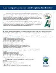
<strong>Lake</strong> <strong>George</strong> Park Commission (LGPC) Boat Registration<br />
All vessels 18 feet or longer, or any vessel mechanically propelled by a motor 10 h.p. or<br />
greater, must register with the <strong>Lake</strong> <strong>George</strong> Park Commission and display a registration<br />
decal. Boats can pay for daily or weekly temporary registrations. If a boat is on <strong>Lake</strong> <strong>George</strong><br />
for more than 21 days annually, then the boat must have an annual registration.<br />
<strong>Steward</strong>s checked for the registration decal on boats so that the information could be<br />
provided to the LGPC. The LGPC provided the <strong>Lake</strong> <strong>Steward</strong>s with a handout <strong>of</strong> what the<br />
different types <strong>of</strong> registration decals look like so they would know what they were looking<br />
for. Compliance was over 70% at all the launches - with Norowal Marina have the highest<br />
average compliance at 95%. The managers at Norowal sell the boat registrations at their<br />
marina and actively tell their customers about the regulation. Registrations are also<br />
available at Island View Marina. Boaters do not have the opportunity to register their boat<br />
at the other launches that stewards were at - they would have to have registered it prior to<br />
arriving at the launch.<br />
Conclusion<br />
The <strong>Lake</strong> <strong>George</strong> <strong>Watershed</strong> <strong>Lake</strong> <strong>Steward</strong> <strong>Program</strong> had a very successful summer. The<br />
<strong>Lake</strong> <strong>Steward</strong>s inspected 2,984 boats that had come from 159 different waterbodies in 19<br />
different states. A total <strong>of</strong> 113 samples were collected <strong>of</strong>f <strong>of</strong> 76 boats. 61 <strong>of</strong> the samples<br />
were identified as invasive species. 4 different invasives were found on the boats, 3 <strong>of</strong><br />
which are already in <strong>Lake</strong> <strong>George</strong>. Eurasian watermilfoil, zebra mussels, and curly-leaf<br />
pondweed were all removed from boats that had both come from other lakes and that had<br />
also last been in <strong>Lake</strong> <strong>George</strong>. Water chestnut was also removed from boats on 4 different<br />
occasions, saving <strong>Lake</strong> <strong>George</strong> from another invasion. The <strong>Lake</strong> <strong>Steward</strong>s also collected<br />
other recreational user data that is valuable to the state agencies and private entities<br />
operating the launch facilities. Over 70% <strong>of</strong> boaters at all <strong>of</strong> the launches self-reported<br />
that they had taken spread prevention measures prior to arriving at the launch. It is hard to<br />
know how biased this finding is, however, it is still encouraging.<br />
The results <strong>of</strong> this summer’s program clearly<br />
show the need for continued invasive species<br />
education and spread prevention programs.<br />
They also show the effectiveness <strong>of</strong> the<br />
<strong>Lake</strong> <strong>Steward</strong> <strong>Program</strong>. Hopefully, we will<br />
have funding to continue and to improve this<br />
program in the future so we can continue our<br />
efforts to protect the waters <strong>of</strong> <strong>Lake</strong> <strong>George</strong> by<br />
slowing the spread <strong>of</strong> aquatic invasive species.<br />
% Yes<br />
Spread Prevention Measures Taken<br />
100<br />
85<br />
88<br />
92<br />
95<br />
78<br />
80<br />
72<br />
74<br />
60<br />
40<br />
20<br />
0<br />
N M M P D B H T R R N W IV<br />
Launch<br />
Figure 22: Summary <strong>of</strong> spread prevention measures.<br />
20 <strong>Lake</strong> <strong>George</strong> <strong>Watershed</strong> <strong>Lake</strong> <strong>Steward</strong> <strong>Program</strong> <strong>End</strong> <strong>of</strong> <strong>Season</strong> Report 2008
DRAFT<br />
Norowal Marina<br />
Bolton Landing<br />
Introduction<br />
For the third consecutive summer a <strong>Lake</strong> <strong>Steward</strong> was stationed at Norowal Marina in<br />
Bolton Landing. Norowal Marina is owned by the Bolton Local Development Corporation<br />
and is launch site and parking facility with a close proximity to “The Narrows”, a closely<br />
spaced group <strong>of</strong> islands that is a popular camping destination only minutes from the launch.<br />
Norowal Marina provides an excellent opportunity to survey a high volume <strong>of</strong> lake users and<br />
present information about both the invasive species already present in <strong>Lake</strong> <strong>George</strong> and<br />
those that have not yet been introduced into the lake. While the <strong>Lake</strong> <strong>Steward</strong>s visually<br />
inspected the vessels as they entered and left the lake, stewards concentrated on educating<br />
the public about how to prevent the spread <strong>of</strong> invasive species. Due to the high volume <strong>of</strong><br />
island campers using the launch, Norowal Marina also provides a good opportunity to inform<br />
campers <strong>of</strong> the invasive species that can be transported by firewood. A <strong>Lake</strong> <strong>Steward</strong> was<br />
stationed at Norowal Marina five days a week from May 23 to August 17, 2008.<br />
Methods<br />
The <strong>Lake</strong> <strong>Steward</strong> was stationed at Norowal<br />
Marina from 8 am to 4:30 pm Wednesday through<br />
Sunday. The <strong>Lake</strong> <strong>Steward</strong>s were initially trained<br />
with the Paul Smith’s College stewards in May,<br />
and later received training by the NYSDEC, the<br />
Darrin Freshwater Institute, and the <strong>Lake</strong> <strong>George</strong><br />
Park Commission. Each <strong>Lake</strong> <strong>Steward</strong> was given<br />
a handbook, visual aids, handouts, dichotomous<br />
key for aquatic plant identification, and forms to<br />
record data from each party and accompanying<br />
vessel entering and leaving the lake. The <strong>Lake</strong><br />
<strong>Steward</strong> recorded information such as boat type,<br />
horsepower (outboard only), stroke (outboard<br />
only), group size, state <strong>of</strong> registration, presence<br />
<strong>of</strong> a current <strong>Lake</strong> <strong>George</strong> Park Commission decal,<br />
time arrived and departed.<br />
21 <strong>Lake</strong> <strong>George</strong> <strong>Watershed</strong> <strong>Lake</strong> <strong>Steward</strong> <strong>Program</strong> <strong>End</strong> <strong>of</strong> <strong>Season</strong> Report 2008
DRAFT<br />
The <strong>Lake</strong> <strong>Steward</strong> also recorded where visitors had used their boats last and if they had<br />
taken steps to prevent the spread <strong>of</strong> invasive species, such as washing their boats and<br />
draining their bilge water. The <strong>Lake</strong> <strong>Steward</strong> typically set up a chair and a table with handout<br />
information about invasive species and other information pertaining to <strong>Lake</strong> <strong>George</strong>. The<br />
<strong>Lake</strong> <strong>Steward</strong> table was located at the convergence <strong>of</strong> the two entrance roads to the launch<br />
ramp. Due to the setup location it was difficult for the <strong>Lake</strong> <strong>Steward</strong> to inspect boats leaving<br />
the lake. The collected information was entered into an Excel database at the <strong>Lake</strong> <strong>George</strong><br />
Association then later compiled and analyzed.<br />
Results<br />
Number <strong>of</strong> Boats<br />
Over the thirteen week period that a <strong>Lake</strong> <strong>Steward</strong> was stationed at Norowal Marina a total<br />
<strong>of</strong> 1264 boats were recorded entering <strong>Lake</strong> <strong>George</strong> by a <strong>Lake</strong> <strong>Steward</strong>. Information for each<br />
vessel was recorded and interpreted. The manager <strong>of</strong> Norowal Marina recorded 2,293 boats<br />
launching during the same time frame. A <strong>Lake</strong> <strong>Steward</strong> was at the marina for 48 days out <strong>of</strong><br />
87 days from May 23 - Aug 17.<br />
The <strong>Lake</strong> <strong>Steward</strong>s intercepted 55% <strong>of</strong> boaters using Norowal Marina during 13 weeks <strong>of</strong><br />
the summer. A steward was at the marina for 48 out <strong>of</strong> 87 days, which is also 55%. So it<br />
appears that the <strong>Lake</strong> <strong>Steward</strong>s were very effective in interacting with boaters when they<br />
were at the launch. This is important to know because this launch can get very busy at<br />
times. With the launch being so busy, boaters can become less willing to interact with the<br />
steward. However, it appears that the stewards did a great job <strong>of</strong> handing this situation.<br />
Boat launch use by week varied greatly<br />
throughout the summer (figure 1).<br />
Memorial Day at the end <strong>of</strong> May started<br />
the season <strong>of</strong>f with over 100 boats<br />
launching over the long weekend from<br />
Friday to Monday. The busiest week<br />
(Wed-Sun) was over the 4th <strong>of</strong> July, with<br />
212 boats; 79 <strong>of</strong> which launched from<br />
8:00-4:30 pm on July 4th and were<br />
inspected by a <strong>Lake</strong> <strong>Steward</strong>. The end <strong>of</strong><br />
July and beginning <strong>of</strong> August was also a<br />
busy time for a number <strong>of</strong> weeks.<br />
Saturday was the busiest day <strong>of</strong> the<br />
week, with Friday a close second (figure<br />
2). Wednesday and Thursday were not<br />
nearly as busy as the weekends as<br />
was expected. This data will help us<br />
to evaluate if stewards should work at<br />
launches for 5 days again next year or<br />
if working just Fri - Sun makes the most<br />
sense.<br />
Number <strong>of</strong> Boats<br />
200<br />
150<br />
100<br />
50<br />
0<br />
Boat Launch Use at Norowal Marina by Week<br />
5/ 23 - 5/26<br />
5/ 29 - 6/1<br />
6/ 05 - 6/08<br />
6/ 11 - 6/15<br />
6/ 18 - 6/22<br />
6/ 25 - 6/29<br />
7/ 02 - 7/06<br />
7/ 09 - 7/13<br />
7/ 16 - 7/20<br />
7/ 23 - 7/27<br />
7/ 30 - 8/03<br />
8/ 06 - 8/10<br />
8/ 13 - 8/17<br />
Figure 1: A summary <strong>of</strong> boat launches by week at Norowal.<br />
# <strong>of</strong> boats launched<br />
4 5 0<br />
4 0 0<br />
3 5 0<br />
3 0 0<br />
2 5 0<br />
2 0 0<br />
1 5 0<br />
1 0 0<br />
5 0<br />
0<br />
Date<br />
Boat Launch by Weekday at Norowal Marina<br />
95<br />
16 11<br />
79<br />
337<br />
397<br />
28 36 25<br />
W T H F S A S U<br />
day <strong>of</strong> the week<br />
a ve ra g e<br />
279<br />
to ta l<br />
Figure 2: A comparison <strong>of</strong> boat launch by day <strong>of</strong> the week.<br />
22 <strong>Lake</strong> <strong>George</strong> <strong>Watershed</strong> <strong>Lake</strong> <strong>Steward</strong> <strong>Program</strong> <strong>End</strong> <strong>of</strong> <strong>Season</strong> Report 2008
DRAFT<br />
Vessel Types<br />
A total <strong>of</strong> 1,136 motorboats make up 90% <strong>of</strong> the vessels<br />
entering the <strong>Lake</strong> <strong>George</strong> via Norowal Marina. Of the<br />
remaining 10%, 9% consisted <strong>of</strong> personal watercraft (PWC) and<br />
1% were sailboats. There was 1 canoe and 0 kayaks launched<br />
at Norowal while the steward was on duty.<br />
The manager <strong>of</strong> Norowal Marina provided us with records <strong>of</strong><br />
vessels launched during the same dates a <strong>Lake</strong> <strong>Steward</strong>s was<br />
stationed there, May 23 - Aug. 17. The records show a total <strong>of</strong><br />
2,293 boats launching, with 1,715 motorboats, 22 sailboats,<br />
124 PWC, and 19 cartops (canoes and kayaks). They also<br />
had 413 day pass launchers, <strong>of</strong> which type <strong>of</strong> boat is not<br />
recorded. Using the numbers provided by Norowal, 91% <strong>of</strong><br />
the boats were motorboats, 7% were PWC, and both cartops<br />
and sailboats were 1%. This is very close to the percentages<br />
that the steward interactions amounted to as well. This shows<br />
that the data from the steward interactions is a representative<br />
sample <strong>of</strong> the boaters using the marina during the time they<br />
were there.<br />
While the majority <strong>of</strong> vessels launched at Norowal Marina were<br />
motorboats, 9% (figure 3) <strong>of</strong> vessels launched at this location<br />
were PWCs. The sailboats launched at Norowal Marina were<br />
<strong>of</strong>ten at the launch for longer periods <strong>of</strong> time due to the time<br />
needed to rig the boat. Since there is a fee associated with<br />
launching a vessel at Norowal Marina most canoes and kayaks<br />
are probably launched at the nearby Northwest Bay Car Top<br />
Launch which is free <strong>of</strong> charge. The low numbers <strong>of</strong> canoes<br />
and kayaks that do enter <strong>Lake</strong> <strong>George</strong> through Norowal Marina<br />
are <strong>of</strong>ten launched on another larger vessel and put into the<br />
lake after they have departed the launch.<br />
Motor Types<br />
Motor type for each vessel was recorded and vessels with<br />
outboard motors were categorized by stroke (2 or 4 stroke).<br />
Almost three-quarters <strong>of</strong> the motorboats that launched at<br />
Norowal Marina were inboard while the remaining one-quarter<br />
were outboard. Of the outboard motors observed, 72% were<br />
recorded to be 2-stroke while 28% were 4-stroke.<br />
M PWC<br />
S C<br />
Figure 3: A comparison <strong>of</strong> vessel<br />
types that launched at Norowal.<br />
Figure 4: Comparison <strong>of</strong> vessel<br />
types that launched at Norowal.<br />
Outboard<br />
30%<br />
Vessel Type<br />
1%<br />
9%<br />
0%<br />
Motor Type<br />
90%<br />
Vessel Type from Norowal's Records<br />
1 %<br />
7 % 1 %<br />
9 1 %<br />
m o to rb o a t sa ilb o a t p wc ca rto p<br />
Figure 5: Comparison <strong>of</strong> motor<br />
types.<br />
Outboard Engine Type<br />
Inboard<br />
70%<br />
F our S troke<br />
28%<br />
T w o S troke<br />
72%<br />
<strong>Lake</strong> <strong>Steward</strong>s learning how to identify motors during training.<br />
Figure 6: Comparison <strong>of</strong> outboard<br />
motor stroke.<br />
23 <strong>Lake</strong> <strong>George</strong> <strong>Watershed</strong> <strong>Lake</strong> <strong>Steward</strong> <strong>Program</strong> <strong>End</strong> <strong>of</strong> <strong>Season</strong> Report 2008
DRAFT<br />
<strong>Lake</strong> <strong>George</strong> Park Commission Decals<br />
<strong>Lake</strong> <strong>George</strong> Park Commission Decals are required by law for any vessel mechanically<br />
propelled by more than 10 horsepower and non-mechanically propelled greater than 18 feet<br />
in length.<br />
% Compliance<br />
100<br />
90<br />
80<br />
70<br />
60<br />
50<br />
40<br />
30<br />
20<br />
10<br />
0<br />
5/ 23/0 8-5/2 6/0 8<br />
5/ 29/0 8-6/1 /08<br />
% Compliance with LGPC Decals<br />
6/ 5/08 -6/8/ 08<br />
6/ 11/0 8-6/1 5/0 8<br />
6/ 18/0 8-6/2 2/0 8<br />
6/ 25/0 8-6/2 9/0 8<br />
7/ 2/08 -7/6/ 08<br />
7/ 9/08 -7/13 /08<br />
7/ 16/0 8-7/2 0/0 8<br />
Date<br />
7/ 23/0 8-7/2 7/0 8<br />
7/ 30/0 8-8/3 /08<br />
8/ 6/08 -8/10 /08<br />
8/ 13/0 8-8/1 7/0 8<br />
Figure 7: Weekly comparison <strong>of</strong> <strong>Lake</strong> <strong>George</strong> Park Commission Decal<br />
compliance at Norowal Marina.<br />
Samples <strong>of</strong> a boat<br />
registration decal and a<br />
temporary registration decal.<br />
<strong>Lake</strong> <strong>George</strong> Park Commission decal compliance remained over 80% for each <strong>of</strong> the<br />
thirteen weeks that a <strong>Lake</strong> <strong>Steward</strong> was stationed at Norowal Marina. An average <strong>of</strong><br />
95% compliance was found for the total thirteen weeks. A possible cause for the drop in<br />
compliance in July is the increased number <strong>of</strong> out <strong>of</strong> town tourists who are not familiar with<br />
the <strong>Lake</strong> <strong>George</strong> Park Commission regulations. Most locals are aware <strong>of</strong> the <strong>Lake</strong> <strong>George</strong><br />
Park Commission decal, as they have been boating on <strong>Lake</strong> <strong>George</strong> in the past.<br />
Of the 1264 boats that entered <strong>Lake</strong> <strong>George</strong> via Norowal Marina 1184 displayed a decal<br />
while 64 vessels did not display a decal. There were 16 vessels that were not required to<br />
display a decal (figure<br />
7). The over 95%<br />
compliance throughout<br />
the thirteen weeks can<br />
be partially attributed<br />
to the Norowal Marina<br />
Managers. The Norowal<br />
Marina Managers made<br />
their customers aware<br />
<strong>of</strong> the decal if the vessel<br />
required one for use on<br />
<strong>Lake</strong> <strong>George</strong>.<br />
24 <strong>Lake</strong> <strong>George</strong> <strong>Watershed</strong> <strong>Lake</strong> <strong>Steward</strong> <strong>Program</strong> <strong>End</strong> <strong>of</strong> <strong>Season</strong> Report 2008
DRAFT<br />
Previous <strong>Lake</strong> <strong>Steward</strong> Interaction<br />
It was recorded whether or not the boaters had a previous interaction with a <strong>Lake</strong> <strong>Steward</strong>.<br />
% Yes<br />
1 0 0<br />
9 0<br />
8 0<br />
7 0<br />
6 0<br />
5 0<br />
4 0<br />
3 0<br />
2 0<br />
1 0<br />
0<br />
5 /2 3/0 8 -5/2 6 /0 8<br />
5 /2 9/0 8 -6/1 /0 8<br />
Previous <strong>Lake</strong> <strong>Steward</strong> Interaction<br />
6 /5 /0 8 -6 /8 /0 8<br />
6 /1 1/0 8 -6/1 5 /0 8<br />
7 /9 /0 8 -7 /1 3 /0 8<br />
6 /1 8/0 8 -6/2 2 /0 8<br />
6 /2 5/0 8 -6/2 9 /0 8<br />
7 /2 /0 8 -7 /6 /0 8<br />
7 /1 6/0 8 -7/2 0 /0 8<br />
7 /2 3/0 8 -7/2 7 /0 8<br />
7 /3 0/0 8 -8/3 /0 8<br />
8 /6 /0 8 -8 /1 0 /0 8<br />
8 /1 3/0 8 -8/1 7 /0 8<br />
Figure 8: Weekly comparison <strong>of</strong> boaters that have had a previous<br />
interaction with a <strong>Lake</strong> <strong>Steward</strong>.<br />
Throughout the thirteen weeks the percentage <strong>of</strong> boaters that had previous <strong>Lake</strong> <strong>Steward</strong><br />
interaction fluctuated, which shows that many different boaters enter <strong>Lake</strong> <strong>George</strong> through<br />
Norowal Marina during the summer. There were many repeat users at the marina as well as<br />
a steady flow <strong>of</strong> vacationers in town for a few days. Another reason there was less repeated<br />
interaction with a <strong>Lake</strong> <strong>Steward</strong> is that several local marinas use Norowal Marina to launch<br />
boats as well as to launch rental boats.<br />
Date<br />
However, there still are a number <strong>of</strong> repeat users at the launch.<br />
With season-pass holders and multiple use boaters at Norowal<br />
Marina it was important that the <strong>Lake</strong> <strong>Steward</strong> note whether or<br />
not a previous interaction had taken place. Once an interaction<br />
had occurred the boater was given a trailer sticker to indicate<br />
that an interaction had taken place (sticker pictured on this<br />
page). The <strong>Lake</strong> <strong>Steward</strong> recorded “Y” for Previous <strong>Lake</strong><br />
<strong>Steward</strong> interaction if a sticker was visible, or if during conversation it became apparent<br />
that an interaction had taken place in the past. Over time we can determine if there is any<br />
correlation between having a previous <strong>Lake</strong> <strong>Steward</strong> interaction and several other variables<br />
such as a decrease in invasive species entering <strong>Lake</strong> <strong>George</strong>, or an increase in Prevention<br />
Steps taken to prevent the spread <strong>of</strong> invasive species.<br />
25 <strong>Lake</strong> <strong>George</strong> <strong>Watershed</strong> <strong>Lake</strong> <strong>Steward</strong> <strong>Program</strong> <strong>End</strong> <strong>of</strong> <strong>Season</strong> Report 2008
DRAFT<br />
Previous Waterbodies<br />
The <strong>Lake</strong> <strong>Steward</strong>s recorded which waterbody boats had been in contact with immediately<br />
preceding their entry into <strong>Lake</strong> <strong>George</strong>.<br />
Previous Waterbody Frequency Waterbody<br />
Frequency<br />
Atlantic Ocean 29 <strong>Lake</strong> Sivi (OH) * 1<br />
Ballston <strong>Lake</strong> (NY) 2 <strong>Lake</strong> Sunapee (NH) 1<br />
Bantam <strong>Lake</strong> (CT) 2 <strong>Lake</strong> Walcott (NH) 1<br />
Barnegat Bay (NJ) 8 <strong>Lake</strong> Wallenpaupack (PA) 11<br />
Beltsville <strong>Lake</strong> (PA) 4 <strong>Lake</strong> Winnipesaukee (NH) 3<br />
Blue Water Marsh (PA) 2 <strong>Lake</strong> Winnisquam (NH) 1<br />
Boston Harbor (MA) 1 Lillinonah <strong>Lake</strong> (CT) 1<br />
Boston <strong>Lake</strong> (CT) 1 Little York <strong>Lake</strong> (NY) 1<br />
Brant <strong>Lake</strong> (NY) 2 Long Island Sound (NY) 22<br />
Buckhorn <strong>Lake</strong> (ONT) 1 Manasquam River (NJ) 1<br />
Buzzards Bay (MA) 1 Mansfield Reservoir (CT) 1<br />
Canandaigua <strong>Lake</strong> (NY) 1 Marrow Creek (NJ) * 1<br />
Canadarago <strong>Lake</strong> (NY) 1 Mohawk River (NY) 6<br />
Candlewood <strong>Lake</strong> (CT) 13 Navesink River (NJ) 2<br />
Cayuga <strong>Lake</strong> (NY) 1 Ohio River 1<br />
Chesapeake Bay (MD) 2 Onota <strong>Lake</strong> (MA) 6<br />
Connecticut River (CT) 18 Oswego River (NY) 1<br />
Connamessett <strong>Lake</strong> (MA) 1 Otis Reservoir (MA) 5<br />
Coventry <strong>Lake</strong> (CT) 1 Otsego <strong>Lake</strong> (NY) 1<br />
Cranberry <strong>Lake</strong> (NJ) 1 Phantom <strong>Lake</strong> (CT) 1<br />
Crystal <strong>Lake</strong> (IL) 1 Pawtucket River (RI) 1<br />
Delaware River (DE) 8 Peach <strong>Lake</strong> (NY) 1<br />
Glen <strong>Lake</strong> (NY) 1 Piseco <strong>Lake</strong> (NY) 1<br />
Great Egg Harbor River (NJ) 2<br />
Pontoosuc <strong>Lake</strong> (MA) 1<br />
Great South Bay (NY) 3<br />
Raystown <strong>Lake</strong> (PA) 1<br />
Greenwood <strong>Lake</strong> (NY) 9<br />
Round Valley Reservoir (NJ) 1<br />
Gulf <strong>of</strong> Mexico 1<br />
Ruisetumn <strong>Lake</strong> (PA) * 1<br />
Hamilton Reservoir (MA) 4<br />
Sacandaga <strong>Lake</strong> (NY) 11<br />
Harriman Reservoir (VT) 4<br />
Sandy Hook Bay (NJ) 2<br />
Highland <strong>Lake</strong> (NY) 1<br />
Saratoga <strong>Lake</strong> (NY) 25<br />
Schroon <strong>Lake</strong> (NY) 7<br />
Holland Reservoir (MA) * 1<br />
Seneca <strong>Lake</strong> (NY) 1<br />
Hudson River (NY) 35<br />
Shepherd <strong>Lake</strong> (NJ) 1<br />
Indian <strong>Lake</strong> (NY) 3<br />
Shrewsbury River (NJ) 1<br />
Jordan <strong>Lake</strong> (NC) 1<br />
Silver <strong>Lake</strong> (NY) 1<br />
<strong>Lake</strong> Champlain (NY) 6<br />
Skaneateles <strong>Lake</strong> (NY) 2<br />
<strong>Lake</strong> Congamond (MA) 1<br />
Sp<strong>of</strong>ford <strong>Lake</strong> (NH) 1<br />
<strong>Lake</strong> Erie 2<br />
Spruce Run State Park (NJ) 1<br />
<strong>Lake</strong> <strong>George</strong> (NY) 531 St. Lawrence River (NY) 4<br />
<strong>Lake</strong> Harmony (PA) 1 Stockbridge Bowl <strong>Lake</strong> (MA) 1<br />
<strong>Lake</strong> Hopatcong (NJ) 39 Susquehanna River 2<br />
<strong>Lake</strong> Housatonic (CT) 1 Swinging Bridge Reservoir (NY) 4<br />
<strong>Lake</strong> Kerr (FL) 1 Upper Woods Pond (PA) 1<br />
<strong>Lake</strong> Luzerne (NY) 1 Wallum <strong>Lake</strong> (RI) 1<br />
<strong>Lake</strong> Mahopac (NY) 3 Watatic Pond (MA) 1<br />
<strong>Lake</strong> Mohawk (NJ) 1 Webster <strong>Lake</strong> (NH) 2<br />
<strong>Lake</strong> Ontario 1 Whiteham <strong>Lake</strong> (MA)) * 1<br />
<strong>Lake</strong> Pleasant (NY) 1 Windsor Pond (MA) 1<br />
<strong>Lake</strong> Rescue (VT) 1 Zoar <strong>Lake</strong> (CT) 1<br />
* <strong>Steward</strong>s did not always have the chance to ask for correct spelling from boaters. This results in occasional<br />
names <strong>of</strong> bodies <strong>of</strong> water which may be misspelled, named with local slang, or unidentifiable.<br />
Figure 9: Name and frequency <strong>of</strong> previously visited waterbodies.<br />
26 <strong>Lake</strong> <strong>George</strong> <strong>Watershed</strong> <strong>Lake</strong> <strong>Steward</strong> <strong>Program</strong> <strong>End</strong> <strong>of</strong> <strong>Season</strong> Report 2008
DRAFT<br />
Boats launching at Norowal Marina had visited approximately 97 different water bodies before<br />
entering <strong>Lake</strong> <strong>George</strong>. The highest frequency <strong>of</strong> previous water bodies was <strong>Lake</strong> <strong>George</strong> with 531.<br />
The highest frequency <strong>of</strong> non-<strong>Lake</strong> <strong>George</strong> water bodies visited was <strong>Lake</strong> Hopatcong in New Jersey,<br />
which contains several invasive species, many <strong>of</strong> which were found by <strong>Lake</strong> <strong>Steward</strong>s on vessels that<br />
were last in its waters.<br />
Information about previous water bodies entered is important because it can be used to determine<br />
where outreach efforts should be focused in the future. Several <strong>of</strong> the highest frequency water bodies<br />
(Saratoga <strong>Lake</strong>, <strong>Lake</strong> Hopatcong (NJ), and the Hudson River) (figure 10) contain invasive species that<br />
have not yet been introduced into <strong>Lake</strong> <strong>George</strong>.<br />
Most Common Previously Visited Waterbodies<br />
(excluding <strong>Lake</strong> <strong>George</strong>)<br />
L a ke W a lle np a up a ck<br />
11<br />
S a ca nd a g a L a ke<br />
11<br />
C a nd le w o o d L a ke<br />
13<br />
Body <strong>of</strong> Water<br />
C o nne cticut R ive r<br />
L o ng Isla nd S o und<br />
S a ra to g a L a ke<br />
A tla ntic O ce a n<br />
18<br />
22<br />
25<br />
29<br />
H ud so n R ive r<br />
35<br />
L a ke H o p a tco ng<br />
39<br />
0 5 1 0 1 5 2 0 2 5 3 0 3 5 4 0<br />
Number <strong>of</strong> Boats<br />
Figure 10: Name and frequency <strong>of</strong> most common previously visited waterbodies (excluding <strong>Lake</strong> <strong>George</strong>).<br />
31 <strong>of</strong> the 97 bodies <strong>of</strong> water listed<br />
in Figure 9 are from NY. The rest<br />
are from a variety <strong>of</strong> states. After<br />
New York State, the most common<br />
states were Massachusetts and<br />
New Jersey with 13 different<br />
waterbodies and Connecticut<br />
with 10. There were also bodies<br />
<strong>of</strong> water which cover more than<br />
one state, and the <strong>Lake</strong> <strong>Steward</strong><br />
was unable to collect the state.<br />
The Atlantic Ocean, the Gulf <strong>of</strong><br />
Mexico, <strong>Lake</strong> Ontario, <strong>Lake</strong> Erie,<br />
the Susquehanna River, and the<br />
Ohio River were all also recorded<br />
as previous waterbodies visited.<br />
Previously Visited Waterbodys outside <strong>of</strong><br />
2 % New York State<br />
2 %<br />
2 %<br />
2 %<br />
2 1 %<br />
3 %<br />
3 %<br />
1 0 %<br />
2 1 %<br />
1 2 %<br />
1 6 %<br />
M a ssa chuse tts<br />
N e w Je rse y<br />
C o nne cticut<br />
P e nnsylva nia<br />
N e w H a m p shire<br />
V e rm o nt<br />
R ho d e Isla nd<br />
M a ryla nd<br />
Illinio s<br />
F lo rid a<br />
N o rth C a ro lina<br />
D e la w a re<br />
O hio<br />
O nta rio<br />
Figure 11: Previous Waterbody Locations from outside <strong>of</strong> NY.<br />
27 <strong>Lake</strong> <strong>George</strong> <strong>Watershed</strong> <strong>Lake</strong> <strong>Steward</strong> <strong>Program</strong> <strong>End</strong> <strong>of</strong> <strong>Season</strong> Report 2008
DRAFT<br />
Plants/Organisms Found<br />
Each vessel entering the lake was inspected for any plant material/organisms. Samples<br />
were collected and then identified by either a <strong>Lake</strong> <strong>Steward</strong> or by Larry Eichler at the Darrin<br />
Fresh Water Institute. Boats were also inspected leaving the lake when possible.<br />
Plants/Organisms Going In<br />
2%<br />
% Native versus Invasive<br />
N o<br />
Y es<br />
N ative<br />
39%<br />
Invas ive<br />
61%<br />
98%<br />
Figure 12: Comparison <strong>of</strong> boats found<br />
with and without plants/organisms.<br />
Figure 13: Comparison <strong>of</strong> native vs. invasive<br />
specimens found.<br />
A total <strong>of</strong> 45 samples were collected from 31 boats entering <strong>Lake</strong> <strong>George</strong> at Norowal Marina<br />
and 1 boat leaving. The 31 boats entering make up 2% <strong>of</strong> the total boats launching at<br />
Norowal Marina during the thirteen weeks a <strong>Lake</strong> <strong>Steward</strong> was stationed there. Norowal<br />
Marina’s 2% <strong>of</strong> boats entering with plants/organisms is the second highest among the<br />
launches visited by <strong>Lake</strong> <strong>Steward</strong>s this summer. Some boats had more than one type <strong>of</strong><br />
plant on them, which resulted in more samples than the number <strong>of</strong> boats carrying the<br />
samples. For instance, 1 boat entering had 3 different species <strong>of</strong> native plants found on<br />
it, while another boat had both curly-leaf pondweed and Eurasian watermilfoil on it, both <strong>of</strong><br />
which are invasive aquatic plants. Zebra mussels were found on two different boats, 1 <strong>of</strong><br />
which had been in the Saratoga <strong>Lake</strong> earlier that same day.<br />
Eurasian watermilfoil (Myriophyllum spicatum), zebra mussels (Dreissena polymorpha),<br />
curly-leaf pondweed (Potomogeton crispus), and water chestnut (Trapa natans) were all<br />
invasive species removed from boats about to enter <strong>Lake</strong> <strong>George</strong>. 28 <strong>of</strong> the 45 samples<br />
were invasive, so more than half <strong>of</strong> the samples turned out to be invasive species prevented<br />
from entering the lake (figure 13).<br />
A wide variety <strong>of</strong> native plants<br />
were found, including: slender-leaf<br />
pondweed, flat-stem pondweed,<br />
Vasey’s pondweed, coontail, water<br />
marigold, narrow-leaf pondweed,<br />
eel grass, duck celery, and a few<br />
other types <strong>of</strong> native pondweeds<br />
and waterweeds. Of the invasive<br />
plants found, Eurasian watermilfoil<br />
was the most common, followed by<br />
curly-leaf pondweed (figure 14).<br />
Number <strong>of</strong> Invasive Specimens Found<br />
8<br />
1<br />
2<br />
17<br />
E uras ian W aterm ilfoil<br />
W ater C hes tnut<br />
C urly -leaf P ondw eed<br />
Zebra M us s els<br />
Figure 14: Summary <strong>of</strong> invasive species removed from boats.<br />
28 <strong>Lake</strong> <strong>George</strong> <strong>Watershed</strong> <strong>Lake</strong> <strong>Steward</strong> <strong>Program</strong> <strong>End</strong> <strong>of</strong> <strong>Season</strong> Report 2008
DRAFT<br />
Of the 28 samples <strong>of</strong> invasives, 1 sample <strong>of</strong> Eurasian watermilfoil was removed from a boat<br />
leaving the launch. The other 27 were all removed from boats about to enter the lake. The<br />
date, species, last waterbody visited, and how long ago the boat was in that waterbody are<br />
listed below. It appears that <strong>Lake</strong> <strong>George</strong> is continually re-infecting itself by moving its own<br />
populations <strong>of</strong> Eurasian watermilfoil and curly-leaf pondweed around. <strong>Lake</strong> Champlain,<br />
Saratoga <strong>Lake</strong>, and the Hudson River are not surprising possible local sources <strong>of</strong> invasives,<br />
but Candlewood <strong>Lake</strong> in CT and <strong>Lake</strong> Hopatcong in NJ are interesting finds.<br />
Date Invasive Last Waterbody When<br />
June 5 Eurasian watermilfoil <strong>Lake</strong> Champlain < 1 week<br />
June 13 Water chestnut Hudson River last year<br />
June 14 Eurasian watermilfoil <strong>Lake</strong> Champlain < 1 week<br />
June 21 Eurasian watermilfoil <strong>Lake</strong> Champlain < 1 week<br />
June 27 Eurasian watermilfoil Candlewood <strong>Lake</strong> (CT) not recorded<br />
June 28 Eurasian watermilfoil <strong>Lake</strong> <strong>George</strong> < 1 week<br />
June 29 Eurasian watermilfoil Candlewood <strong>Lake</strong> (CT) > 1 week<br />
July 3 Eurasian watermilfoil Candlewood <strong>Lake</strong> (CT) 2 days<br />
July 3 Curly-leaf pondweed Saratoga <strong>Lake</strong> 1 day<br />
July 4 Eurasian watermilfoil <strong>Lake</strong> <strong>George</strong> 1 week<br />
July 4 Zebra mussel <strong>Lake</strong> <strong>George</strong> 1 week<br />
July 6 Zebra mussel Saratoga <strong>Lake</strong> same day<br />
July 16 Eurasian watermilfoil <strong>Lake</strong> <strong>George</strong> last season<br />
July 18 Curly-leaf pondweed <strong>Lake</strong> <strong>George</strong> last season<br />
July 18 Curly-leaf pondweed <strong>Lake</strong> <strong>George</strong> 1 month<br />
July 19 Curly-leaf pondweed <strong>Lake</strong> <strong>George</strong> 4 days<br />
July 19 Curly-leaf pondweed Hudson River 2 weeks<br />
July 19 Eurasian watermilfoil Hudson River 2 weeks<br />
July 19 Curly-leaf pondweed Oneida <strong>Lake</strong> 3 weeks<br />
July 19 Curly-leaf pondweed <strong>Lake</strong> <strong>George</strong> 2 weeks<br />
July 25 Eurasian watermilfoil Glen <strong>Lake</strong> < 1 week<br />
July 25 Curly-leaf pondweed <strong>Lake</strong> <strong>George</strong> 2 weeks<br />
July 26 Eurasian watermilfoil Saratoga <strong>Lake</strong> 1 week<br />
Aug 2 Eurasian watermilfoil <strong>Lake</strong> Hopatcong (NJ) 3 weeks<br />
Aug 10 Eurasian watermilfoil <strong>Lake</strong> Hopatcong (NJ) 1 week<br />
Aug 17 Eurasian watermilfoil Candlewood <strong>Lake</strong> (CT) 2 weeks<br />
Aug 17 Eurasian watermilfoil <strong>Lake</strong> Hopatcong (NJ) < 2 weeks<br />
Figure 15: List <strong>of</strong> invasives found on boats about to launch at Norowal Marina.<br />
Water chestnut nutlets that were<br />
removed <strong>of</strong>f a boat at Norowal<br />
Marina on June 13 that had last<br />
been in the Hudson River the<br />
previous year.<br />
29 <strong>Lake</strong> <strong>George</strong> <strong>Watershed</strong> <strong>Lake</strong> <strong>Steward</strong> <strong>Program</strong> <strong>End</strong> <strong>of</strong> <strong>Season</strong> Report 2008
DRAFT<br />
Forest Pests<br />
Norowal Marina also provided an excellent opportunity to educate the public about other<br />
non-aquatic invasive species such as the Asian longhorn beetle, the emerald ash borer and<br />
the sirex woodwasp. These invasive insects are transported via untreated firewood, which<br />
is a concern at this launch site due to the high number <strong>of</strong> island campers transporting<br />
firewood from locations known to have infestations <strong>of</strong> these invasive insects. Norowal Marina<br />
is close to many <strong>of</strong> the <strong>Lake</strong> <strong>George</strong> Islands which are a very popular camping location. The<br />
stewards provided an interpretive message about firewood and invasive insects to boaters<br />
who appeared to be camping and had firewood with them. During the summer, emergency<br />
regulations were enacted by the NYS DEC making it illegal to move firewood more than 50<br />
miles. While not an enforcer, the <strong>Lake</strong> <strong>Steward</strong>s did make campers aware <strong>of</strong> these new<br />
regulations. When people who had brought firewood from more than 50 miles away were<br />
not willing to leave their firewood behind, they were instructed to please burn all <strong>of</strong> it or to<br />
bring whatever was not burned back on the boat with them. One group from Long Island<br />
actually did leave their firewood (which they had brought with them from Long Island) in their<br />
car after talking to the steward. The rest <strong>of</strong> the boaters seemed to appreciate the message<br />
and said they would buy local firewood the next time.<br />
Figure 17: % <strong>of</strong> boaters who self-reported<br />
having taken spread prevention measures.<br />
Conclusion<br />
%<strong>of</strong> Boaters who took<br />
Spread Prevention Steps<br />
No<br />
15%<br />
Y es<br />
85%<br />
Spread Prevention<br />
1072 <strong>of</strong> the boaters reported taking some sort <strong>of</strong><br />
step to prevent the spread <strong>of</strong> invasive species prior to<br />
arriving to launch their boat. After asking the boater<br />
if he/she had taken any spread prevention steps, the<br />
<strong>Lake</strong> <strong>Steward</strong> supplied examples <strong>of</strong> what possible<br />
prevention steps are if needed, such as inspecting<br />
your boat, washing your boat, draining your bilge, bait<br />
bucket, or live well or disposing <strong>of</strong> your bait.<br />
Over the thirteen weeks that a <strong>Lake</strong> <strong>Steward</strong> was at Norowal Marina it became clear that this<br />
was an important location in educating the public about invasive species and how to prevent<br />
them from spreading. There were more <strong>Lake</strong> <strong>Steward</strong>-Boater interactions, 1264, at Norowal<br />
Marina than any other boat launch worked by a <strong>Lake</strong> <strong>Steward</strong> this summer. There were<br />
also a high number <strong>of</strong> boaters using the launch at this location coming from water bodies<br />
impacted by invasive species. In general the public response toward the <strong>Lake</strong> <strong>Steward</strong>s was<br />
positive and well received. Due to the high volume <strong>of</strong> boats being launched at this location<br />
there was <strong>of</strong>ten a limit on the amount <strong>of</strong> time given to interact with boaters. This time<br />
limit presented a challenge to the <strong>Lake</strong> <strong>Steward</strong> in that they must convey a message about<br />
preventing the spread <strong>of</strong> invasive species while not hindering business. Norowal Marina is<br />
a private marina in which the customers pay for launching and parking. Since this marina is<br />
private the <strong>Lake</strong> <strong>Steward</strong> must bear that in mind when interacting with the public, who are<br />
also customers <strong>of</strong> a business. Norowal Marina is an excellent location for the <strong>Lake</strong> <strong>Steward</strong>s<br />
to be interacting with, and educating, the public on ways to prevent the spread <strong>of</strong> invasive<br />
species.<br />
30 <strong>Lake</strong> <strong>George</strong> <strong>Watershed</strong> <strong>Lake</strong> <strong>Steward</strong> <strong>Program</strong> <strong>End</strong> <strong>of</strong> <strong>Season</strong> Report 2008
DRAFT<br />
Mossy Point Boat Launch<br />
Ticonderoga NY<br />
Introduction<br />
For the third year the <strong>Lake</strong> <strong>George</strong> <strong>Watershed</strong> Conference has stationed a <strong>Lake</strong> <strong>Steward</strong> at Mossy<br />
Point boat launch. This year <strong>Lake</strong> <strong>Steward</strong>s were posted there from May 24 to August 22 with Mondays<br />
and Tuesdays <strong>of</strong>f. Mossy Point is state owned and operated under the New York State Department<br />
<strong>of</strong> Environmental Conservation. Located at the northern-most end <strong>of</strong> <strong>Lake</strong> <strong>George</strong>, Mossy Point in<br />
Ticonderoga provides local residents with a large, easily accessible, no cost boat launch. Also, with its<br />
ability to launch up to four vessels at a time, Mossy Point is one <strong>of</strong> the largest launch sites on the lake.<br />
Mossy Point does attract some out-<strong>of</strong>-state boaters, but a large number <strong>of</strong> launch users live nearby.<br />
<strong>Steward</strong>s stationed at Mossy Point provided information about the lake and invasive species to visitors as<br />
well as inspected all watercraft coming in or out <strong>of</strong> the lake for invasive plants.<br />
Methods<br />
The primary duty <strong>of</strong> the <strong>Lake</strong> <strong>Steward</strong> posted at Mossy Point boat launch was to talk to every boater<br />
and ask questions that corresponded to the <strong>Lake</strong> <strong>George</strong> Recreational Use Study Data Sheets. Some<br />
information such as boat type, horsepower, group size, registration number, and time arrived and left<br />
were able to be written down without asking any questions to the actual boater. Other information such<br />
as the last body <strong>of</strong> water, the prevention<br />
measures taken, and previous interaction<br />
with lake stewards needed to be asked<br />
to the boaters. After answers to these<br />
questions were attained the <strong>Lake</strong> <strong>Steward</strong><br />
could proceed to inspecting the watercraft<br />
for any signs <strong>of</strong> invasive species or any<br />
plant matter. Usually boaters are interested<br />
enough in what the <strong>Lake</strong> <strong>Steward</strong> is doing<br />
that they will do this inspection along<br />
with them. This gives the <strong>Lake</strong> <strong>Steward</strong><br />
additional time to inform the boater <strong>of</strong><br />
good locations to inspect boats.<br />
31 <strong>Lake</strong> <strong>George</strong> <strong>Watershed</strong> <strong>Lake</strong> <strong>Steward</strong> <strong>Program</strong> <strong>End</strong> <strong>of</strong> <strong>Season</strong> Report 2008
DRAFT<br />
Also stationed at Mossy Point on some weekends is a temporary boat wash station. On<br />
days <strong>of</strong> higher activity, the <strong>Lake</strong> <strong>Steward</strong>(s) can operate the boat wash station. After a<br />
boater has been asked a series <strong>of</strong> questions and their boat is inspected it is up to the <strong>Lake</strong><br />
<strong>Steward</strong> to assess whether or not this particular watercraft is “at risk”. “At risk” watercraft<br />
have recently come out <strong>of</strong> another body <strong>of</strong> water known to have invasive species or a boat<br />
where the boater has recently been in another body <strong>of</strong> water and has taken no spread<br />
prevention measures. If the watercraft is considered to be a threat the <strong>Lake</strong> <strong>Steward</strong> would<br />
highly advocate the boat be washed. From here, the boater can simply say no but on most<br />
occasions they are willing to help. The watercraft is towed onto a containment mat that<br />
holds all the water that is washed <strong>of</strong>f the boat from the power washer. The boat washing<br />
component <strong>of</strong> the program is discussed in the Recommendations and Future Considerations<br />
section <strong>of</strong> this report.<br />
Results<br />
Number <strong>of</strong> Boats<br />
Over the course <strong>of</strong> the summer 949 watercraft were surveyed at the Mossy Point launch.<br />
This was the second busiest launch that a <strong>Lake</strong> <strong>Steward</strong> was stationed at during the<br />
summer. The week <strong>of</strong> the 4th <strong>of</strong> July was the busiest with 209 boats recorded by the<br />
steward from Fri - Sun at the launch. Other peak use times appear around Memorial Day<br />
in May at and the end <strong>of</strong> July. This use is relatively consistent with trend <strong>of</strong> boat use on the<br />
lake during the summer.<br />
Saturdays had the most<br />
traffic at Mossy Point, a<br />
total <strong>of</strong> 364 boats and an<br />
average <strong>of</strong> 30 boats per<br />
Saturday. Sunday was a<br />
close second, with a total <strong>of</strong><br />
304 boats and an average<br />
<strong>of</strong> 28 boats per Sunday.<br />
Wednesday, Thursday, and<br />
Friday were all very slow,<br />
with Thursday having the<br />
least numbers <strong>of</strong> boats<br />
overall and on<br />
average.<br />
The boat by day trend is<br />
similar to that also found at<br />
Norowal Marina, with both<br />
launches having Thursday<br />
with the fewest boats and<br />
Saturday with the most.<br />
However, Fridays appeared<br />
to be more popular than<br />
Sundays at Norowal, and<br />
the opposite is true here.<br />
Number <strong>of</strong> Boats<br />
200<br />
150<br />
100<br />
50<br />
0<br />
Boat Launch Use by Week<br />
Figure 1: Summary <strong>of</strong> boat launch use by week.<br />
# <strong>of</strong> boats launched<br />
5 0 0<br />
4 0 0<br />
3 0 0<br />
2 0 0<br />
1 0 0<br />
0<br />
5/24 - 5/25<br />
5/26 - 6/01<br />
6/05 - 6/08<br />
6/11 - 6/15<br />
6/18 - 6/22<br />
6/25 - 6/29<br />
7/02 - 7/06<br />
7/09 - 7/13<br />
7/16 - 7/20<br />
7/23 - 7/27<br />
7/30 - 8/03<br />
8/06 - 8/10<br />
8/13 - 8/17<br />
Figure 2: A comparison <strong>of</strong> boat launch by day <strong>of</strong> the week.<br />
32 <strong>Lake</strong> <strong>George</strong> <strong>Watershed</strong> <strong>Lake</strong> <strong>Steward</strong> <strong>Program</strong> <strong>End</strong> <strong>of</strong> <strong>Season</strong> Report 2008<br />
Date<br />
Boat Launch by Weekday at Mossy Point<br />
337<br />
397<br />
95 79<br />
16 11 28 36 25<br />
W T H F S A S U<br />
day <strong>of</strong> the week<br />
a ve ra g e<br />
279<br />
to ta l
Sailboat at Mossy Point launch.<br />
DRAFT<br />
Motor<br />
PWC<br />
Sailboat<br />
Canoe<br />
Kayak<br />
0%<br />
1%<br />
9%<br />
Figure 3: Vessel types coming in and out.<br />
Vessel Type<br />
0%<br />
90%<br />
Vessel Type<br />
Over the course <strong>of</strong> the summer 949 watercrafts were surveyed at Mossy Point launch.<br />
Of the watercraft surveyed 90% were motorboats, 9% were PWCs, and 1% were sailboats.<br />
Kayaks and canoes were counted in much smaller numbers and only consisted <strong>of</strong> a fraction<br />
<strong>of</strong> a percent.<br />
As the percentages show, the majority <strong>of</strong> use at Mossy Point comes from motor boats and<br />
PWCs. Sailboats, canoes, and kayaks were recorded in much smaller numbers mainly<br />
because <strong>of</strong> a small inlet just up the road that some canoers and kayakers seem to use.<br />
Motor Types<br />
The motorboats are divided into two categories:<br />
inboard and outboard. Outboards are then<br />
categorized into two types: two-stroke and fourstroke.<br />
Outboard Engine Type<br />
20%<br />
Of the different types motors, approximately<br />
two-thirds were counted as inboards, with the<br />
remaining one-third being outboards. The 37%<br />
<strong>of</strong> outboards can then further be divided into<br />
2-strokes, 80%, and 4-strokes, 20%.<br />
The data shown in the graphs to the right<br />
makes it clear that the bulk <strong>of</strong> the boats coming<br />
into the launch were inboard boats. This could<br />
be due to the fact that Mossy Point is a large<br />
launch, which makes it more accommodating<br />
to larger, inboard engine boats. Of the outboard<br />
population, 2-stroke engines are definitely the<br />
more popular choice. 2-strokes are a cheaper<br />
engine that makes it appealing to most boaters;<br />
however they are not nearly as fuel efficient as<br />
4-stroke engines.<br />
2-Stroke<br />
Figure 4: Proportion <strong>of</strong> 2-stroke engines to 4-<br />
strokes<br />
Motor Type<br />
Figure 5: Proportion <strong>of</strong> inboard engines to<br />
outboard engines.<br />
33 <strong>Lake</strong> <strong>George</strong> <strong>Watershed</strong> <strong>Lake</strong> <strong>Steward</strong> <strong>Program</strong> <strong>End</strong> <strong>of</strong> <strong>Season</strong> Report 2008<br />
37%<br />
Inboard<br />
80%<br />
4-Stroke<br />
63%<br />
Outboard
LGPC Decals<br />
Boaters are required to have <strong>Lake</strong><br />
<strong>George</strong> Park Commission stickers on<br />
their vessels if their boat is longer than<br />
18 ft. or has an engine <strong>of</strong> 10 horsepower<br />
or greater. <strong>Lake</strong> <strong>Steward</strong>s simply noted<br />
if boats had them or not, they were not<br />
enforcing the use <strong>of</strong> them.<br />
Over time the percent <strong>of</strong> people who had<br />
Park Commission decals seemed to rise<br />
slightly. The average percent <strong>of</strong> people<br />
with LGPC decals was 76%. This is much<br />
lower than the average compliance <strong>of</strong><br />
95% at Norowal Marina. This difference<br />
could be explained by the fact that there<br />
is no person manning the Mossy Point<br />
Boat Launch, informing boaters <strong>of</strong> the<br />
rules and providing the opportunity to<br />
purchase a decal on location.<br />
Although there is a slight upward trend<br />
in this graph it doesn’t necessarily<br />
prove that more and more people were<br />
purchasing decals. The spikes and dips<br />
in the graph could be attributed to the<br />
influx <strong>of</strong> tourists coming in from other<br />
places because they were unaware <strong>of</strong><br />
the use <strong>of</strong> LGPC decals.<br />
DRAFT<br />
% Compliance with LGPC Decals<br />
% Compliance<br />
Figure 6: Percent <strong>of</strong> people who had LGPC decals on their<br />
boats over time.<br />
Percent Yes<br />
120<br />
100<br />
Previous <strong>Lake</strong> <strong>Steward</strong> Interaction<br />
Figure 7: Percent <strong>of</strong> people who had previous contact with<br />
<strong>Lake</strong> <strong>Steward</strong>s.<br />
Previous <strong>Lake</strong> <strong>Steward</strong> Interaction<br />
One <strong>of</strong> the first questions asked is whether or not they have previously interacted with a <strong>Lake</strong><br />
<strong>Steward</strong>. This lets the <strong>Lake</strong> <strong>Steward</strong> know that they may be familiar with the information<br />
about to be presented.<br />
The average percent <strong>of</strong> people who had previous interaction with <strong>Lake</strong> <strong>Steward</strong>s was about<br />
59% with some weeks averaging more than 70%.<br />
80<br />
60<br />
40<br />
20<br />
0<br />
5/24 - 5/25<br />
5/26 - 6/01<br />
80<br />
70<br />
60<br />
50<br />
40<br />
30<br />
20<br />
10<br />
0<br />
6/05 - 6/08<br />
6/11 - 6/15<br />
6/18 - 6/22<br />
6/25 - 6/29<br />
7/02 - 7/06<br />
7/09 - 7/13<br />
Date<br />
5/24 - 5/25<br />
5/26 - 6/01<br />
6/05 - 6/08<br />
6/11 - 6/15<br />
6/18 - 6/22<br />
6/25 - 6/29<br />
7/02 - 7/06<br />
7/09 - 7/13<br />
7/16 - 7/20<br />
Date<br />
7/16 - 7/20<br />
7/23 - 7/27<br />
7/30 - 8/03<br />
8/06 - 8/10<br />
8/13 - 8/17<br />
7/23 - 7/27<br />
7/30 - 8/03<br />
8/06 - 8/10<br />
8/13 - 8/17<br />
As the above graph shows, there<br />
appears to be an upward trend over<br />
time. Over the summer more and more<br />
people seemed to be people the <strong>Lake</strong><br />
<strong>Steward</strong>s recognized as someone<br />
they had talked to many times before.<br />
However, like before, the spikes and<br />
dips in the graph are likely related to<br />
tourist activity and people coming in<br />
from out <strong>of</strong> state.<br />
34 <strong>Lake</strong> <strong>George</strong> <strong>Watershed</strong> <strong>Lake</strong> <strong>Steward</strong> <strong>Program</strong> <strong>End</strong> <strong>of</strong> <strong>Season</strong> Report 2008
DRAFT<br />
Previous Waterbodies<br />
By the end <strong>of</strong> the summer there were a recorded 37 different lakes and rivers that boaters<br />
were coming into <strong>Lake</strong> <strong>George</strong> from.<br />
Previous Waterbody Frequency<br />
Atlantic Ocean 7<br />
Annabessacook <strong>Lake</strong> (ME) 1<br />
Onota <strong>Lake</strong> (MA) 1<br />
Bantam <strong>Lake</strong> (CT) 1<br />
Beltsville <strong>Lake</strong> (PA) 1<br />
Brant <strong>Lake</strong> (NY) 2<br />
Candlewood <strong>Lake</strong> (CT) 4<br />
Cassian <strong>Lake</strong> (NY) * 1<br />
Chesapeake Bay (MD) 2<br />
Clarke Pond (NY) 1<br />
Connecticut River (CT) 2<br />
Delaware River (DE) 1<br />
Fairview <strong>Lake</strong> (FL) 1<br />
Framingham <strong>Lake</strong> (MA) 1<br />
Greenwood <strong>Lake</strong> (NY) 6<br />
Hudson River (NY) 8<br />
Key West (FL) 1<br />
<strong>Lake</strong> Bomoseen (VT) 6<br />
<strong>Lake</strong> Champlain (VT) 37<br />
<strong>Lake</strong> Dunmore (VT) 3<br />
<strong>Lake</strong> <strong>George</strong> (NY) 812<br />
<strong>Lake</strong> Hopatcong (NJ) 4<br />
<strong>Lake</strong> St. Catherine (VT) 1<br />
Lily <strong>Lake</strong> (PA) 1<br />
Mohawk River (NY) 2<br />
Paradox <strong>Lake</strong> (NY) 2<br />
Putnam Pond (NY) 2<br />
Plunkett <strong>Lake</strong> (MA) 1<br />
Round <strong>Lake</strong> (NJ) 2<br />
Sacandaga <strong>Lake</strong> (NY) 3<br />
Saratoga <strong>Lake</strong> (NY) 10<br />
Schroon <strong>Lake</strong> (NY) 8<br />
St. Lawrence River (NY) 1<br />
Seneca <strong>Lake</strong> (NY) 1<br />
Waterbury Reservoir (VT) 1<br />
Whalen <strong>Lake</strong> * 1<br />
Webster <strong>Lake</strong> (MA) 1<br />
* <strong>Steward</strong>s did not always have the chance to<br />
ask for correct spelling from boaters. This results<br />
in occasional names <strong>of</strong> bodies <strong>of</strong> water which<br />
may be misspelled or named with local slang.<br />
Table 1: List <strong>of</strong> every previous waterbody visited<br />
along with its frequency.<br />
Of the 37 water bodies listed, most are located in<br />
New York, Vermont, or New Hampshire. Second<br />
to <strong>Lake</strong> <strong>George</strong> in last body visited was <strong>Lake</strong><br />
Champlain at 37.<br />
The most common last body <strong>of</strong> water was <strong>Lake</strong><br />
<strong>George</strong>. This can be attributed to the fact that<br />
many people who live in or around the area stay<br />
loyal to <strong>Lake</strong> <strong>George</strong> and never visit other lakes.<br />
The next most visited lake is <strong>Lake</strong> Champlain.<br />
This makes sense because <strong>of</strong> Mossy Point’s close<br />
proximity to a <strong>Lake</strong> Champlain launch. Because<br />
<strong>of</strong> the closeness there is an inherent problem;<br />
many boaters are pulling out <strong>of</strong> Champlain and<br />
launching into <strong>Lake</strong> <strong>George</strong> within a relatively<br />
short period time. This makes boats coming out<br />
<strong>of</strong> Champlain <strong>of</strong> significant interest to the <strong>Lake</strong><br />
<strong>Steward</strong> because <strong>of</strong> <strong>Lake</strong> Champlain’s notoriously<br />
high invasive species count <strong>of</strong> 48.<br />
# <strong>of</strong> boats<br />
40<br />
35<br />
30<br />
25<br />
20<br />
15<br />
10<br />
Most Common Previous Waterbodies<br />
(excluding <strong>Lake</strong> <strong>George</strong>)<br />
Waterbody<br />
Figure 8: Summary <strong>of</strong> most common previous waterbodies.<br />
It is alarming to find that all <strong>of</strong> the most common<br />
previous freshwater waterbodies have invasive<br />
species. The Hudson River has over 90 invasive<br />
species. Both Saratoga <strong>Lake</strong> and <strong>Lake</strong> Bomoseen<br />
have Eurasian watermilfoil and zebra mussels,<br />
and Saratoga <strong>Lake</strong> also has water chestnut and<br />
curly-leaf pondweed. Schroon <strong>Lake</strong> only has<br />
Eurasian watermilfoil. Greenwood <strong>Lake</strong> has<br />
Eurasian watermilfoil as well, and is located in the<br />
same county where hydrilla and snakehead have<br />
recently been discovered.<br />
35 <strong>Lake</strong> <strong>George</strong> <strong>Watershed</strong> <strong>Lake</strong> <strong>Steward</strong> <strong>Program</strong> <strong>End</strong> <strong>of</strong> <strong>Season</strong> Report 2008<br />
5<br />
0<br />
37<br />
<strong>Lake</strong><br />
Champlain<br />
10<br />
Saratoga<br />
<strong>Lake</strong><br />
8<br />
Hudson<br />
River<br />
8<br />
Schroon<br />
<strong>Lake</strong><br />
7<br />
Atlantic<br />
Ocean<br />
6<br />
Greenwood<br />
<strong>Lake</strong><br />
6<br />
<strong>Lake</strong><br />
Bomoseen
5%<br />
16%<br />
11%<br />
Previous Waterbody Locations<br />
outside <strong>of</strong> New York State<br />
11%<br />
5%<br />
5%<br />
11%<br />
20%<br />
16%<br />
Figure 9: Summary <strong>of</strong> Previous Waterbody Locations<br />
outside <strong>of</strong> New York State.<br />
DRAFT 16 <strong>of</strong> the 37 bodies <strong>of</strong> water listed in Table<br />
Maine<br />
Mas s ac hus etts<br />
C onnec tic ut<br />
P enns ylvania<br />
New Jers ey<br />
Verm ont<br />
Maryland<br />
F lorida<br />
D elaw are<br />
1 are in New York State. The rest are from<br />
a variety <strong>of</strong> other states shown in figure<br />
9. There was also a record for the Atlantic<br />
Ocean, which was unable to be assigned<br />
to a state. Massachusetts was the most<br />
common state, with 4 different bodies <strong>of</strong><br />
water. Both Connecticut and Vermont had<br />
3 bodies <strong>of</strong> water that boats had previously<br />
been in, while surprisingly Florida tied New<br />
Jersey and Pennsylvania with 2 bodies<br />
<strong>of</strong> water each. Maine, Maryland, and<br />
Delaware all finish <strong>of</strong>f the list with 1 body<br />
<strong>of</strong> water each.<br />
It should be noted that one waterbody has been left out <strong>of</strong> this analysis. <strong>Lake</strong> Whalen was<br />
recorded as the last body <strong>of</strong> water for a boat launching on June 7th. However, the state was<br />
not recorded, as it turns out there is a <strong>Lake</strong> Whalen in Texas, Michigan, and Wisconsin. The<br />
boat was registered in Mississippi, so it might have been the one in Texas, but there is no<br />
way to know for sure. This sample illustrates the importance <strong>of</strong> gathering complete data as<br />
well as the reality <strong>of</strong> trying to do so.<br />
Plants/Organisms Found<br />
One <strong>of</strong> the main goals <strong>of</strong> the <strong>Lake</strong> <strong>Steward</strong> program is to inspect all incoming vessels for any<br />
plants or organisms. Outgoing vessels are also inspected when possible.<br />
Of all the boats launched at Mossy Point only 2%, or 15 boats,<br />
were found to have plants or organisms attached to them.<br />
Of these 15 samples collected there were 6 specimens <strong>of</strong><br />
2 different invasive species found, Eurasian watermilfoil (5)<br />
and curly-leaf pondweed (1). Although <strong>Lake</strong> <strong>George</strong> is known<br />
to contain both <strong>of</strong> these invasives, the aim is to deter further<br />
colonization and to prevent new types <strong>of</strong> invasive species<br />
from contaminating the lake. The best way to achieve this is<br />
to catch the plants/organisms before they have a chance to<br />
enter the lake and multiply.<br />
Plants/Organisms found on Watercraft<br />
1<br />
Plants/Organisms on Watercrafts<br />
98%<br />
2%<br />
Figure 10: % <strong>of</strong> boats with or<br />
with out plants/organisms<br />
attached.<br />
%Native versus Invasive<br />
Yes<br />
No<br />
5<br />
1<br />
Figure 9: Summary <strong>of</strong> plants found on boats.<br />
3<br />
3<br />
1<br />
Coontail<br />
Nativ e pondw eeds<br />
Nativ e w atermilf oil<br />
Nativ e w aterw eed<br />
Curly -leaf pondw eed<br />
Euras ian w atermilf oil<br />
In va s ive<br />
4 3 %<br />
Figure 11: Comparison <strong>of</strong> native<br />
versus invasive specimens found.<br />
36 <strong>Lake</strong> <strong>George</strong> <strong>Watershed</strong> <strong>Lake</strong> <strong>Steward</strong> <strong>Program</strong> <strong>End</strong> <strong>of</strong> <strong>Season</strong> Report 2008<br />
N a tive<br />
5 7 %
DRAFT<br />
Spread Prevention<br />
Boaters were asked by the steward if they had taken spread<br />
prevention steps such as washing their boat, draining their<br />
bilge, etc. 542 boaters reported taking spread prevention<br />
while 264 said they had not. A unique addition to the Mossy<br />
Point Launch site was a Nuisance Invasive Species Disposal<br />
Station. This station was built by the NYSDEC and the<br />
stewards helped out by installing the signage on the station.<br />
The drop box is provided for boaters to place plant material<br />
removed from their boat on the rocks to dry and desiccate.<br />
The box keeps the plant matter contained so that it does not<br />
wash back into the lake.<br />
% <strong>of</strong> Boaters who took<br />
Spread Prevention Steps<br />
Yes<br />
72%<br />
No<br />
28%<br />
Figure 12: % <strong>of</strong> boaters who<br />
self-reported taking spread<br />
prevention steps.<br />
Eurasian watermilfoil growing<br />
next to the Mossy Point boat<br />
launch dock.<br />
Conclusion<br />
Eurasian watermilfoil washed up<br />
on the Mossy Point boat launch<br />
ramp.<br />
Nuisance Invasive Species Removal<br />
Station at Mossy Point.<br />
Due to the high volume <strong>of</strong> boats coming into Mossy Point launch it was an essential launch<br />
to have a <strong>Lake</strong> <strong>Steward</strong> stationed. Mossy Point is located in a unique location in that it<br />
gets visitors from various regions. There is a large population <strong>of</strong> returning boaters who are<br />
local to the area and easy for <strong>Lake</strong> <strong>Steward</strong>s to remember. These locals are usually some <strong>of</strong><br />
the more receptive people the <strong>Lake</strong> <strong>Steward</strong>s get to associate with. There are also a good<br />
number <strong>of</strong> boats coming in from <strong>Lake</strong> Champlain and other parts <strong>of</strong> Vermont considering<br />
the closeness to the area. The danger that comes with being so close to <strong>Lake</strong> Champlain,<br />
as stated previously, is that there are multiple invasive species such as water chestnut,<br />
alewives, and European frog-bit that could enter <strong>Lake</strong> <strong>George</strong> via boats. In addition, there<br />
are a lot <strong>of</strong> tourists coming into <strong>Lake</strong> <strong>George</strong> from other places. This results in multiple<br />
boaters bringing their boats from other lakes straight to <strong>Lake</strong> <strong>George</strong>. Many <strong>of</strong> these tourists<br />
may not have any idea what invasive species are and may be unaware that they can transfer<br />
them from one lake to another. When you bring together these three aspects one can see<br />
how Mossy Point State Boat Launch is a high-use launch with plenty <strong>of</strong> potential to be an<br />
introduction point <strong>of</strong> invasive plant/organisms into <strong>Lake</strong> <strong>George</strong>.<br />
37 <strong>Lake</strong> <strong>George</strong> <strong>Watershed</strong> <strong>Lake</strong> <strong>Steward</strong> <strong>Program</strong> <strong>End</strong> <strong>of</strong> <strong>Season</strong> Report 2008
DRAFT<br />
38 <strong>Lake</strong> <strong>George</strong> <strong>Watershed</strong> <strong>Lake</strong> <strong>Steward</strong> <strong>Program</strong> <strong>End</strong> <strong>of</strong> <strong>Season</strong> Report 2008
DRAFT<br />
Dunham’s Bay Marina<br />
<strong>Lake</strong> <strong>George</strong>, NY<br />
Introduction<br />
For the first season, a <strong>Lake</strong> <strong>Steward</strong> was stationed at Dunham’s Bay Marina. This launch<br />
site is a private boat launch, located at the southern end <strong>of</strong> <strong>Lake</strong> <strong>George</strong>. Due to private<br />
ownership, being conscientious and respectful <strong>of</strong> customers’ time was important. For<br />
the high-use marina that it is, Dunham’s Bay has a few challenges. In order to reach<br />
<strong>Lake</strong> <strong>George</strong> from the bay area (which is where the launch ramp is located) boats and<br />
boaters have to go under a low bridge; this limits the launch to smaller boats. Also, due<br />
to the location, boaters originating from Dunham’s Bay Marina are <strong>of</strong>ten headed out to<br />
campgrounds, requiring the steward to be prepared to address other environmental issues.<br />
The <strong>Lake</strong> <strong>George</strong> <strong>Watershed</strong> <strong>Steward</strong> is responsible for educating boaters on the threat <strong>of</strong><br />
invasive species, as well as prevention steps to stop the spread into other water bodies.<br />
They visually inspected boats and removed any weeds or organisms found. The <strong>Steward</strong> was<br />
also to inform visitors on other environmental issues, such as run<strong>of</strong>f pollution and invasive<br />
insects which spread by the movement <strong>of</strong> firewood to different locations. The <strong>Lake</strong> <strong>Steward</strong><br />
was located at Dunham’s Bay boat launch, providing this educational program throughout<br />
the summer.<br />
Methods<br />
<strong>Lake</strong> <strong>George</strong> <strong>Watershed</strong> <strong>Steward</strong>s<br />
participated in a week long training session<br />
at Paul Smith’s College as well as a week<br />
long training in <strong>Lake</strong> <strong>George</strong>. Throughout<br />
their training they learned about invasive<br />
species, interpretation and interaction with<br />
visitors.<br />
A <strong>Lake</strong> <strong>Steward</strong> was placed at Dunham’s<br />
Bay, five days a week, 8:00 am to 4:30 pm<br />
between the dates <strong>of</strong> June 5, 2008 through<br />
August 17, 2008.<br />
39 <strong>Lake</strong> <strong>George</strong> <strong>Watershed</strong> <strong>Lake</strong> <strong>Steward</strong> <strong>Program</strong> <strong>End</strong> <strong>of</strong> <strong>Season</strong> Report 2008
DRAFT<br />
The <strong>Steward</strong> would be located at the launch ramp and would take down visible information<br />
such as the boat registration number, the motor type, and the number <strong>of</strong> people. Once<br />
outside their vehicle the <strong>Lake</strong> <strong>Steward</strong> would approach the boater, greet them, give a brief<br />
introduction as to why they are there and state general information about invasive species.<br />
The boater is then asked a series <strong>of</strong> questions relating to the cleanliness <strong>of</strong> their boat, such<br />
as if they have cleaned their boat, drained their bilge, and if they have drained their live<br />
wells. They are also asked what water bodies the boat had been in the previous two weeks.<br />
Finally the <strong>Lake</strong> <strong>Steward</strong> would visually inspect the boat and remove any organisms or plant<br />
fragments found. Samples would be removed from boats, which would then be placed in a<br />
bag partially filled with lake water and taken to Darrin Fresh Water Institute for identification.<br />
Results<br />
Number <strong>of</strong> Boats<br />
A total <strong>of</strong> 437 vessels were inspected before entering <strong>Lake</strong> <strong>George</strong> by way <strong>of</strong> Dunham’s<br />
Bay Marina. Information from each vessel was recorded and interpreted. Boat launch use<br />
by week varied throughout the summer, with an expected peak around the Fourth <strong>of</strong> July<br />
holiday with 121 boats launching from July 2-6.<br />
Number <strong>of</strong> Boats<br />
1 2 5<br />
1 0 0<br />
7 5<br />
5 0<br />
2 5<br />
0<br />
6 /0 5 /08 - 6 /0 8 /0 8<br />
Figure 1: Summary <strong>of</strong> boat launches by week.<br />
# <strong>of</strong> boats<br />
2 0 0<br />
1 5 0<br />
1 0 0<br />
5 0<br />
6 /1 1 /08 - 6 /1 5 /0 8<br />
0<br />
6 /1 8 /08 - 6 /2 2 /0 8<br />
6 /2 5 /08 - 6 /2 9 /0 8<br />
Boat Launch Use by Week<br />
7 /0 9 /08 - 7 /1 3 /0 8<br />
7 /0 2 /08 - 7 /0 6 /0 8<br />
7 /2 3 /08 - 7 /2 7 /0 8<br />
7 /1 6 /08 - 7 /2 0 /0 8<br />
Date<br />
7 /3 0 /08 - 8 /0 3 /0 8<br />
8 /0 6 /08 - 8 /1 0 /0 8<br />
Boats by Weekday at Dunhams Bay<br />
56<br />
46<br />
Figure 2: Comparison <strong>of</strong> boat launch use by day <strong>of</strong><br />
the week.<br />
113<br />
8 /1 3 /08 - 8 /1 7 /0 8<br />
Vessel Types<br />
A total <strong>of</strong> 396 motorboats made up a total<br />
<strong>of</strong> 91% <strong>of</strong> vessels going through the launch.<br />
The remaining 9% <strong>of</strong> vessels consisted <strong>of</strong><br />
6% personal watercrafts, ~0% sailboats, 1%<br />
canoes and 2% kayaks. There was not a<br />
significant number <strong>of</strong> non-motorized vessels;<br />
the majority being motorboats and the minority<br />
were canoes and kayaks (figure 3). Though<br />
it seems that<br />
the canoes and<br />
kayaks were<br />
not prevalent<br />
at this location, it is important to note that this marina has a<br />
separate entrance for car-top boats out <strong>of</strong> view <strong>of</strong> the launch,<br />
which is reserved only for the use <strong>of</strong> non-motorized boats.<br />
Also, there is very little use <strong>of</strong> sailboats at Dunham’s Bay; this<br />
is due to the bridge boats must clear to get out <strong>of</strong> the launch<br />
site and reach <strong>Lake</strong> <strong>George</strong>. This makes it impossible for tall<br />
vessels to launch from this site which explains the absence <strong>of</strong><br />
sailboats from this location.<br />
185<br />
8 7 14 21 13<br />
W TH F S A S U<br />
Weekday<br />
a ve ra g e<br />
to ta l<br />
93<br />
Based on <strong>Lake</strong> <strong>Steward</strong> interactions by day <strong>of</strong><br />
the week, Saturday seem to be the busiest day<br />
at the Dunham’s Bay Launch with 185 boats<br />
total and 21 boats on average each Saturday<br />
that a steward was there. Saturday was<br />
followed by Friday and then Sunday for highest<br />
use, with both <strong>of</strong> thee days averaging about the<br />
same use.<br />
Vessel Types<br />
Figure 3 Overall comparison <strong>of</strong><br />
vessel types.<br />
40 <strong>Lake</strong> <strong>George</strong> <strong>Watershed</strong> <strong>Lake</strong> <strong>Steward</strong> <strong>Program</strong> <strong>End</strong> <strong>of</strong> <strong>Season</strong> Report 2008<br />
6%<br />
1%<br />
0%<br />
2%<br />
91%<br />
M PWC S C K
DRAFT<br />
Motor Types<br />
Looking closer at the total 91% <strong>of</strong> motorboats, there was enough information to compare the<br />
different types <strong>of</strong> motors.<br />
23%<br />
Motor Type<br />
31%<br />
Outboard Engine Type<br />
77%<br />
69%<br />
Inboard<br />
Outboard<br />
Figure 4: Overall comparison <strong>of</strong> inboard<br />
and outboard motors.<br />
Figure 5: Overall comparison <strong>of</strong> outboard motors.<br />
Approximately three-quarters <strong>of</strong> motorboats were noted to be inboards and one-quarter were<br />
outboards. Of the outboards, approximately two-thirds were 2-stroke motors (figures 4 & 5).<br />
LGPC Decals<br />
LGPC Decals are required for entry into <strong>Lake</strong> <strong>George</strong>. Although there was no regulating body<br />
at the launch, the presence <strong>of</strong> a decal was noted by the <strong>Lake</strong> <strong>Steward</strong>.<br />
% compliance<br />
100<br />
90<br />
80<br />
70<br />
60<br />
50<br />
40<br />
30<br />
20<br />
10<br />
0<br />
6/ 05 - 6/08<br />
6/ 11 - 6/15<br />
6/ 18 - 6/22<br />
2-Stroke<br />
LGPC Decals % Compliance<br />
6/ 25 - 6/29<br />
7/ 02 - 7/06<br />
7/ 09 - 7/13<br />
date<br />
7/ 16 - 7/20<br />
7/ 23 - 7/27<br />
7/ 30 - 8/03<br />
4-Stroke<br />
8/ 06 - 8/10<br />
8/ 13 - 8/16<br />
Figure 6: Week-by-week comparison <strong>of</strong> <strong>Lake</strong> <strong>George</strong> Park Commission decals compliance.<br />
Compliance with LGPC decals was only below 50% for the first week <strong>of</strong> data collection, and<br />
even then it was very close at 48%. There appears to be no real pattern to compliance.<br />
41 <strong>Lake</strong> <strong>George</strong> <strong>Watershed</strong> <strong>Lake</strong> <strong>Steward</strong> <strong>Program</strong> <strong>End</strong> <strong>of</strong> <strong>Season</strong> Report 2008
DRAFT<br />
One might have guessed that it would decrease around a major holiday, like the 4th <strong>of</strong> July,<br />
with a big influx <strong>of</strong> tourists, but the data shows the opposite with a 93% compliance over the<br />
holiday weekend, which is also the second highest week in terms <strong>of</strong> % compliance. (figure 6).<br />
Previous <strong>Lake</strong> <strong>Steward</strong> Interaction<br />
When talking to boaters it was noted whether there had been previous interaction with a<br />
<strong>Lake</strong> <strong>Steward</strong>.<br />
% Yes<br />
100<br />
90<br />
80<br />
70<br />
60<br />
50<br />
40<br />
30<br />
20<br />
10<br />
0<br />
Previous <strong>Lake</strong> <strong>Steward</strong> Interaction<br />
6/05 - 6/08<br />
6/11 - 6/15<br />
6/18 - 6/22<br />
6/25 - 6/29<br />
7/02 - 7/06<br />
7/09 - 7/13<br />
7/16 - 7/20<br />
7/23 - 7/27<br />
7/30 - 8/03<br />
8/06 - 8/10<br />
8/13 - 8/16<br />
Date<br />
Figure 7: Week-by-week % comparison <strong>of</strong> boaters with previous <strong>Lake</strong> <strong>Steward</strong> interaction.<br />
There was an overall increase <strong>of</strong> people who had had previous interaction with a <strong>Lake</strong><br />
<strong>Steward</strong>. With multiple-use boaters at Dunham’s Bay Marina it was important to note if<br />
the users had previous interaction with a <strong>Lake</strong> <strong>Steward</strong>. After an encounter with a <strong>Lake</strong><br />
<strong>Steward</strong> many boaters were given a sticker to place on their boat trailers as an indication<br />
<strong>of</strong> interaction. The <strong>Steward</strong> recorded whether a sticker was visible, or if during conversion<br />
it was apparent they had previous communication. From this data we can infer that<br />
throughout the summer the outreach has been successful, with an increase <strong>of</strong> boaters who<br />
have had previous contact with a <strong>Lake</strong> <strong>Steward</strong> (figure 7).<br />
42 <strong>Lake</strong> <strong>George</strong> <strong>Watershed</strong> <strong>Lake</strong> <strong>Steward</strong> <strong>Program</strong> <strong>End</strong> <strong>of</strong> <strong>Season</strong> Report 2008
DRAFT<br />
Previous Waterbodies<br />
It was found that there were 41 different bodies <strong>of</strong> water that boats had been in contact with<br />
immediately preceding their entry into <strong>Lake</strong> <strong>George</strong> (Table 1).<br />
Previous Waterbody Frequency<br />
Atlantic Ocean 6<br />
Bantam <strong>Lake</strong> (CT) 1<br />
Brant <strong>Lake</strong> (NY) 1<br />
Candlewood <strong>Lake</strong> (CT) 1<br />
Chesapeake Bay (MD) 1<br />
Connecticut River (CT) 1<br />
Cossayuna <strong>Lake</strong> (NY) 1<br />
Cranberry <strong>Lake</strong> (NY) 1<br />
Delaware River (DE) 3<br />
Fulton Chain <strong>Lake</strong>s (NY) 1<br />
Glen <strong>Lake</strong> (NY) 3<br />
Goose Pond (MA) 1<br />
Great Bay (NJ) 1<br />
Greenwood <strong>Lake</strong> (NY) 3<br />
Hadlock Pond (NY) 1<br />
Higgins <strong>Lake</strong> (MI) 1<br />
Hinckley Reservoir (NY) 1<br />
Hudson River (NY) 22<br />
<strong>Lake</strong> Congamond (MA) 1<br />
<strong>Lake</strong> Champlain (NY) 4<br />
Previous Waterbody Frequency<br />
<strong>Lake</strong> <strong>George</strong> (NY) 254<br />
<strong>Lake</strong> Hopatcong (NJ) 6<br />
<strong>Lake</strong> Marburg (PA) 1<br />
<strong>Lake</strong> Mejantic (Quebec) 1<br />
Long <strong>Lake</strong> (MI) 1<br />
Long Pond (MA) 1<br />
Marrow Creek (NJ) * 1<br />
Mohawk River (NY) 1<br />
Maine (2 unnamed lakes) 2<br />
Otis Reservoir (MA) 1<br />
Potomac River ( MD) 1<br />
Sabattus <strong>Lake</strong> (ME) 1<br />
Sacandaga <strong>Lake</strong> (NY) 4<br />
Saratoga <strong>Lake</strong> (NY) 9<br />
Schroon <strong>Lake</strong> (NY) 6<br />
Skaneatles <strong>Lake</strong> (NY) 1<br />
Star <strong>Lake</strong> (NY) 1<br />
Tennessee River (TN) 1<br />
Wallenpaupack <strong>Lake</strong> (PA) 2<br />
Warners <strong>Lake</strong> (NY) 1<br />
Table 1: Listing and frequency <strong>of</strong> previously entered waterbodies.<br />
* <strong>Steward</strong>s did not always have the chance to ask for correct spelling from boaters. This results in occasional<br />
names <strong>of</strong> bodies <strong>of</strong> water which may be misspelled or named with local slang.<br />
Boats utilizing this launch had visited 41 different water bodies before entering <strong>Lake</strong> <strong>George</strong>.<br />
The majority <strong>of</strong> previous water bodies visited were freshwater lakes and rivers from New York<br />
(i.e. <strong>Lake</strong> <strong>George</strong>, Saratoga <strong>Lake</strong>, and the Hudson River).<br />
Based on frequency, the most common water body previously visited was <strong>Lake</strong> <strong>George</strong>. This<br />
high number <strong>of</strong> 254 vessels that were previously in <strong>Lake</strong> <strong>George</strong> may be attributed to the<br />
fact that Dunham’s Bay Marina caters to locals as well as has many multiple-use customers.<br />
The other most common<br />
freshwater bodies were<br />
Most common waterbodies previously visited<br />
the Hudson River, and the<br />
Saratoga <strong>Lake</strong> (Figure 8). The<br />
proximity <strong>of</strong> these bodies <strong>of</strong><br />
S a ca nd a g a L a ke<br />
L a ke C ha m p la in<br />
4<br />
4<br />
water to <strong>Lake</strong> <strong>George</strong> makes<br />
them common frequented<br />
locations. These places also<br />
A tla ntic O ce a n<br />
L a ke H o p a tco ng<br />
S chro o n L a ke<br />
6<br />
6<br />
6<br />
raise concern; both locations<br />
S a ra to g a L a ke<br />
9<br />
contain invasive species that<br />
H ud so n R ive r<br />
22<br />
are not yet found in <strong>Lake</strong><br />
0 5 1 0 1 5<br />
<strong>George</strong>.<br />
number <strong>of</strong> boats<br />
2 0 2 5<br />
Figure 8: Name and frequency <strong>of</strong> most common previously visited waterbodies (excluding <strong>Lake</strong> <strong>George</strong>).<br />
waterbody<br />
43 <strong>Lake</strong> <strong>George</strong> <strong>Watershed</strong> <strong>Lake</strong> <strong>Steward</strong> <strong>Program</strong> <strong>End</strong> <strong>of</strong> <strong>Season</strong> Report 2008
DRAFT<br />
Of the waterbodies noted, there was a<br />
much greater percentage <strong>of</strong> people who<br />
came from New York State water bodies<br />
most recently, than people coming from<br />
out <strong>of</strong> state. The New York State water<br />
bodies contains 18 different lakes and<br />
rivers. Although there is less frequency<br />
<strong>of</strong> boaters from non-New York State water<br />
bodies, it consists <strong>of</strong> 22 different water<br />
bodies (from approximately 9 different<br />
states (and Canada). Given the large<br />
variety <strong>of</strong> freshwater bodies boats are<br />
originating from, there should be concern<br />
for the threat <strong>of</strong> invasive species at<br />
Dunham’s Bay Boat Launch.<br />
22%<br />
6%<br />
Previous Waterbody Locations outside<br />
<strong>of</strong> New York State<br />
8% 3% 17%<br />
Atlantic Ocean<br />
Canada<br />
6%<br />
11%<br />
8%<br />
Figure 9: Previous waterbody locations from outside <strong>of</strong> NY.<br />
3%<br />
8%<br />
8%<br />
Connecticut<br />
Delaware<br />
Maine<br />
Massachusets<br />
Maryland<br />
Michigan<br />
New Jersey<br />
Pennsylvania<br />
Tennessee<br />
Plants or Organisms Found<br />
Each vessel was inspected for invasive plants and organisms. A total <strong>of</strong> 13 boats were found<br />
to have plant material or organisms on them, 11 were entering and 2 were exiting <strong>Lake</strong><br />
<strong>George</strong>. This produced 28 samples, as some <strong>of</strong> the boats had more than one species <strong>of</strong><br />
plant/animal on it. 11 <strong>of</strong> the specimens from boats were found to be invasive.<br />
Yes<br />
3%<br />
% Native versus Invasive<br />
No<br />
97%<br />
Inv as iv e<br />
39%<br />
Boats with Plants/Organisms going<br />
into <strong>Lake</strong> <strong>George</strong> at Dunham's Bay<br />
Figure 10: Comparison <strong>of</strong> boats found<br />
with and without plants/animals.<br />
Figure 11: Comparison <strong>of</strong> native vs,<br />
invasive specimens found.<br />
Eurasian watermilfoil, water chestnut, and zebra mussels were found on boats at Dunham’s<br />
Bay. 4 samples <strong>of</strong> Eurasian watermilfoil were found, all <strong>of</strong> which were on boats that had<br />
Number <strong>of</strong> Invaisve Specimens Found<br />
3<br />
3<br />
1<br />
Figure 12: Summary <strong>of</strong> invasive species<br />
removed from boats.<br />
4<br />
Curly-leaf pondweed<br />
Eurasian watermilfoil<br />
Water chestnut<br />
Zebra mussels<br />
last been in <strong>Lake</strong> <strong>George</strong>. 3 samples <strong>of</strong> water<br />
chestnut were found, from boats that had last<br />
been in Saratoga <strong>Lake</strong>, <strong>Lake</strong> Champlain, and the<br />
Mohawk River. 3 samples <strong>of</strong> zebra mussels were<br />
found. 2 <strong>of</strong> the samples were from boats last in<br />
Saratoga <strong>Lake</strong>, and 1 <strong>of</strong> the samples came <strong>of</strong>f a<br />
boat that had last been in <strong>Lake</strong> <strong>George</strong>. It cannot<br />
be determined if the zebra mussel had come from<br />
<strong>Lake</strong> <strong>George</strong> or if it had come from a previous body<br />
<strong>of</strong> water and had been on the boat for some time.<br />
44 <strong>Lake</strong> <strong>George</strong> <strong>Watershed</strong> <strong>Lake</strong> <strong>Steward</strong> <strong>Program</strong> <strong>End</strong> <strong>of</strong> <strong>Season</strong> Report 2008<br />
Nativ e<br />
61%
DRAFT<br />
Water chestnut is not currently in <strong>Lake</strong> <strong>George</strong>, although Dunham’s Bay would provide<br />
it with ideal habitat. In a relatively short amount <strong>of</strong> time, invasive species like these<br />
could completely inhabit Dunham’s Bay, out-compete native species and alter the natural<br />
ecosystem. There was a historical water chestnut infestation in the bay but it was eradicated<br />
in the 1990s.<br />
Zebra mussels on Eurasian watermilfoil<br />
found on a boat about to enter <strong>Lake</strong> <strong>George</strong>.<br />
29 Water chestnut nutlets were removed<br />
on June 15 from a boat about to launch<br />
at Dunham’s Bay that had last been in the<br />
Mohawk River less than a week ago.<br />
28 samples were removed from a total <strong>of</strong> 13 boats. 11 <strong>of</strong> the boats were entering <strong>Lake</strong><br />
<strong>George</strong> and 2 <strong>of</strong> the boats were exiting the lake. Some boats had more than one species <strong>of</strong><br />
plant/animal material on them, which created more than one sample per boat. Of the 28<br />
samples, 11 were invasive species. These samples are shown below.<br />
Date Invasive Last Waterbody When<br />
August 8 Eurasian watermilfoil <strong>Lake</strong> Hopatcong < 1 week<br />
August 15 Eurasian watermilfoil Hudson River < 2 weeks<br />
June 13 Zebra mussel Saratoga <strong>Lake</strong> < 1 week<br />
June 21 Water chestnut Saratoga <strong>Lake</strong> 2 weeks<br />
June 25 Water chestnut Mohawk River < 1 week<br />
July 4 Water chestnut South Bay, LC same day<br />
July 4 Eurasian watermilfoil exiting <strong>Lake</strong> <strong>George</strong> --<br />
July 4 Zebra mussel exiting <strong>Lake</strong> <strong>George</strong> --<br />
July 5 Zebra mussel Saratoga <strong>Lake</strong> --<br />
July 6 Eurasian watermilfoil <strong>Lake</strong> <strong>George</strong> 1 day<br />
July 6 Curly-leaf pondweed <strong>Lake</strong> <strong>George</strong> 1 day<br />
Table 2: List <strong>of</strong> invasive removed from boats at Dunham’s Bay Marina.<br />
Most <strong>of</strong> the sources <strong>of</strong> invasive species on boats using the Dunham’s Bay launch came from<br />
neighboring waterbodies, including South Bay on <strong>Lake</strong> Champlain, the Hudson River, and<br />
Saratoga <strong>Lake</strong>. It is unclear if the two invasive species found on their way out were missed<br />
going in or were picked up in <strong>Lake</strong> <strong>George</strong>.<br />
Native plants removed from boats included variable pondweed, threadgrass pondweed,<br />
muskgrass, coontail, duckweed, bladderwort, duck celery, and water marigold among others.<br />
45 <strong>Lake</strong> <strong>George</strong> <strong>Watershed</strong> <strong>Lake</strong> <strong>Steward</strong> <strong>Program</strong> <strong>End</strong> <strong>of</strong> <strong>Season</strong> Report 2008
DRAFT<br />
Spread Prevention<br />
265 boaters reported taking spread prevention steps while 35 did not. This results in 88%<br />
<strong>of</strong> the boaters that the <strong>Lake</strong> <strong>Steward</strong> talked with as taking spread prevention steps before<br />
launching their boat.<br />
% <strong>of</strong> Boaters who took<br />
Spread Prevention Steps<br />
N o<br />
1 2 %<br />
Ye s<br />
8 8 %<br />
Figure 13: % <strong>of</strong> boaters who self-reported that they had<br />
taken spread prevention measures.<br />
Conclusion<br />
Throughout the duration <strong>of</strong> the summer there were a total <strong>of</strong> 437 vessels inspected by a<br />
<strong>Lake</strong> <strong>Steward</strong> before entering <strong>Lake</strong> <strong>George</strong> at this location. The majority <strong>of</strong> users at this<br />
launch were repeat users and welcomed the <strong>Lake</strong> <strong>Steward</strong> to inspect their vessel; they also<br />
encouraged the continued effort to educate people about <strong>Lake</strong> <strong>George</strong>.<br />
Since the bridge the boats must go under limits the size <strong>of</strong> boats launched, smaller boats<br />
launch here than at some other launches. Smaller boats are <strong>of</strong>ten easier to trailer, so this<br />
launch was a concern because it might possibly have had lots <strong>of</strong> boats coming from longer<br />
distances bringing invasives with them. While boats came from 41 different waterbodies,<br />
which is just higher than the 37 from Mossy Point, most <strong>of</strong> the infected boats were local,<br />
and 41 is not a relatively high number compared to the 86 <strong>of</strong> Norowal Marina. It appears<br />
that there were more repeat users than thought, which makes this marina less <strong>of</strong> a threat<br />
to introduce invasive species into the lake than originally thought. Although, having said<br />
that, 11 invasives were still found and removed from boats, and this marina actually had the<br />
highest percentage <strong>of</strong> boats found with plants/organisms on them at 3%, higher than the 2%<br />
at Norowal. This should be kept in mind when planning for future efforts.<br />
46 <strong>Lake</strong> <strong>George</strong> <strong>Watershed</strong> <strong>Lake</strong> <strong>Steward</strong> <strong>Program</strong> <strong>End</strong> <strong>of</strong> <strong>Season</strong> Report 2008
DRAFT<br />
Hague Town Launch<br />
<strong>Lake</strong> <strong>George</strong>, NY<br />
Introduction<br />
Due to the relatively small size <strong>of</strong> the boat launches at Hague, Roger’s Rock Campground,<br />
Northwest Bay, and Island View Marina, a <strong>Lake</strong> <strong>Steward</strong> was not positioned at these launch<br />
as frequently as some <strong>of</strong> the higher volume launches. Following the same procedure, the<br />
<strong>Lake</strong> <strong>Steward</strong> approached the boater and gave a brief interpretive message on preventing<br />
the spread <strong>of</strong> invasive species as well as some background about invasive species in <strong>Lake</strong><br />
<strong>George</strong>. After the interview, the <strong>Lake</strong> <strong>Steward</strong> recorded some visual information including<br />
time <strong>of</strong> arrival, time <strong>of</strong> departure, type <strong>of</strong> watercraft, motor type, and size <strong>of</strong> group. The <strong>Lake</strong><br />
<strong>Steward</strong> then asked the boater whether or not they took any preventative measures, as well<br />
as recorded any waterbodies that the boat had been in during the previous two weeks. The<br />
<strong>Lake</strong> <strong>Steward</strong> would then continue to complete a visual inspection to look for any weeds that<br />
could be attached to the boat and trailer.<br />
Methods<br />
A <strong>Lake</strong> <strong>Steward</strong> was located at the Hague Town Launch for one weekend in June, July, and<br />
again in August. The launch is owned and operated by the Town <strong>of</strong> Hague and a small fee <strong>of</strong><br />
ten dollars is required except for Hague residents. Since the boat launch was located in the<br />
center <strong>of</strong> town, parking was restricted to one small lot. The restricted parking area limited<br />
the number <strong>of</strong> boats that could launch and <strong>of</strong>ten created a congested launch ramp. In<br />
addition, the town did not allow<br />
boaters to park their trailers. This<br />
made it difficult for those who did<br />
not live or were not staying nearby.<br />
Located next to the launch<br />
ramp was the town beach and<br />
park. This <strong>of</strong>tentimes provided<br />
the steward with more pedestrian<br />
traffic and concerned residents<br />
rather than boaters.<br />
47 <strong>Lake</strong> <strong>George</strong> <strong>Watershed</strong> <strong>Lake</strong> <strong>Steward</strong> <strong>Program</strong> <strong>End</strong> <strong>of</strong> <strong>Season</strong> Report 2008
Results<br />
DRAFT<br />
Number <strong>of</strong> Boats<br />
152 boats were inspected by a <strong>Lake</strong> <strong>Steward</strong> at the Hague Town Launch. Since the steward<br />
was only at the launch a few times, it does not make sense to try to compare boat launch<br />
use by week. However, we can look at use by day. It just needs to be kept in mind that the<br />
sample size is very small, as a steward was only at the launch for 9 days total, including<br />
only 1 Wednesday and 1 Sunday. Even with a very small sample, when averaged, the launch<br />
appears to follow the same weekly use pattern as other launches on the lake that more data<br />
was gathered from. Saturday has the highest use and Sunday is second, which is the same<br />
as at Mossy Point. The launches in the southern end, Norowal and Dunham’s Bay, had<br />
Friday as the second highest use day. All 4 launches had Wednesday with more traffic than<br />
Thursday, which was an unexpected finding.<br />
# <strong>of</strong> Boats Launched<br />
8 0<br />
7 0<br />
6 0<br />
5 0<br />
4 0<br />
3 0<br />
2 0<br />
1 0<br />
0<br />
Boats by Weekday at Hague Town Launch<br />
10 10 12<br />
6<br />
Figure 1: Comparison <strong>of</strong> average boat launch by day <strong>of</strong> week.<br />
17<br />
34<br />
73<br />
24 23 23<br />
W T H F S A S U<br />
Weekday<br />
a ve ra g e<br />
Figure 2: % <strong>of</strong> vessel types launched<br />
at Hague.<br />
Vessel Types<br />
From June 11th until June 15th, July 17th through the 19th and August 9th, 144 boaters<br />
interacted with a <strong>Lake</strong> <strong>Steward</strong> at Hague. Of these boaters 123 (81%) were motor boaters,<br />
16 (11%) were personal watercraft, 3 canoes (2%), 8 kayaks (5%) and 2 sailboats (1%)<br />
(figure 2).<br />
Motor Types<br />
Of the motorboats recorded, 79 (64 %) were inboard motors and 45 (36%) were outboard<br />
motors. Outboard motors were then differentiated between four-stroke and two-stroke<br />
engines. 31 two-stroke engines (69%) and 14 four-stroke engines (31%) were observed<br />
(figure 3,4).<br />
Although two-stroke and four-stroke data could only be collected for outboard motors, in<br />
general the majority <strong>of</strong> inboard motors are four-stroke engines. The <strong>Lake</strong> <strong>Steward</strong> did not<br />
collect any data regarding inboard engines since the information could not be observed.<br />
The motor type information for only one year is not significant because not enough data was<br />
recorded to measure any trends. After several years <strong>of</strong> collecting data, the information could<br />
be used to determine whether the use <strong>of</strong> four-stroke engines has changed.<br />
to ta l<br />
11%<br />
1%<br />
2%<br />
Vessel Type<br />
5%<br />
81%<br />
M PWC S C K<br />
48 <strong>Lake</strong> <strong>George</strong> <strong>Watershed</strong> <strong>Lake</strong> <strong>Steward</strong> <strong>Program</strong> <strong>End</strong> <strong>of</strong> <strong>Season</strong> Report 2008
Motor Type<br />
DRAFT<br />
Outboard Engine Type<br />
36%<br />
31%<br />
64%<br />
69%<br />
Inboard<br />
Outboard<br />
Figure 3: Comparison <strong>of</strong> motor type.<br />
2-stroke<br />
4-stroke<br />
Figure 4: Comparison <strong>of</strong> outboard motor stroke.<br />
<strong>Lake</strong> <strong>George</strong> Park Commission Decal:<br />
For most boats to launch on <strong>Lake</strong> <strong>George</strong>, it is<br />
required to have a <strong>Lake</strong> <strong>George</strong> Park Commission<br />
registration decal. <strong>Lake</strong> <strong>George</strong> Park Commission<br />
registration is not required for boats shorter than<br />
18 feet and for motors with a horsepower less<br />
than 10.<br />
The <strong>Lake</strong> <strong>Steward</strong> recorded the presence <strong>of</strong> a<br />
<strong>Lake</strong> <strong>George</strong> Park Commission (LGPC) decal. Of<br />
the 141 boats recorded, 97 had decals (68%),<br />
29 did not (21%), and 15 did not need decals<br />
(11%) (See Figure 5). Out <strong>of</strong> boats that did need<br />
a decal, boaters were in compliance 77% <strong>of</strong> the<br />
time.<br />
Previous <strong>Lake</strong> <strong>Steward</strong> Interaction<br />
43 <strong>of</strong> the boaters at the Hague Launch reported<br />
having previously spoken with a <strong>Lake</strong> <strong>Steward</strong>.<br />
In June, only 13 boaters said yes, but when the<br />
steward was there in July, 26 did. This implies<br />
that the Hague launch had some repeat users<br />
during these two months. 101, or 70%, or<br />
the boaters, reported not having had a prior<br />
interaction with a <strong>Lake</strong> <strong>Steward</strong>. Since a <strong>Lake</strong><br />
<strong>Steward</strong> was only at this launch for a total <strong>of</strong> 9<br />
days during the summer, it is not surprising that<br />
many boaters did not have repeat interactions<br />
with the <strong>Lake</strong> <strong>Steward</strong>.<br />
<strong>Lake</strong> <strong>George</strong> Park Commission Decals<br />
Observed<br />
11%<br />
21%<br />
68%<br />
Yes No Not Needed<br />
Figure 5: Overall compliance <strong>of</strong> LGPC decal.<br />
n o<br />
7 0 %<br />
Previous <strong>Lake</strong> <strong>Steward</strong><br />
Interaction<br />
ye s<br />
3 0 %<br />
Figure 6: % <strong>of</strong> boaters who had previously<br />
interacted with a <strong>Lake</strong> <strong>Steward</strong>.<br />
49 <strong>Lake</strong> <strong>George</strong> <strong>Watershed</strong> <strong>Lake</strong> <strong>Steward</strong> <strong>Program</strong> <strong>End</strong> <strong>of</strong> <strong>Season</strong> Report 2008
DRAFT<br />
Previous Waterbodies<br />
The <strong>Lake</strong> <strong>Steward</strong> asked the boater to list any bodies <strong>of</strong> water that the boat had been<br />
in during the previous two weeks. This question generated a wide range <strong>of</strong> answers,<br />
approximately 21 different bodies <strong>of</strong> water (figure 7).<br />
Previous Waterbody<br />
Frequency<br />
Previous Waterbody<br />
Frequency<br />
Atlantic Ocean 1<br />
Barnegat Bay (NJ) 1<br />
Candlewood <strong>Lake</strong> (NY) 2<br />
Cannaan Street <strong>Lake</strong> (NH) 1<br />
Cape Cod (MA) 1<br />
Cassadaga <strong>Lake</strong> (NY) 1<br />
Clinton Res. (NJ) 1<br />
Connecticut River (CT) 1<br />
Greenwood <strong>Lake</strong> (NY) 1<br />
Hudson River (NY) 3<br />
<strong>Lake</strong> Champlain (NY) 2<br />
<strong>Lake</strong> Flower (NY) 1<br />
<strong>Lake</strong> <strong>George</strong> (NY) 90<br />
<strong>Lake</strong> Hopatcong (NJ) 2<br />
Niagara River (NY) 1<br />
Oneida <strong>Lake</strong> (NY) 2<br />
Otsego <strong>Lake</strong> (NY) 1<br />
Round Valley Res. (NJ) 1<br />
Saratoga <strong>Lake</strong> (NY) 2<br />
Sleepy Hollow <strong>Lake</strong> (NY) 1<br />
Stockbridge Bowl <strong>Lake</strong> (MA) 1<br />
Figure 7: Listing and frequency <strong>of</strong> previously entered waterbodies.<br />
* <strong>Steward</strong>s did not always have the chance to ask for correct spelling from boaters. This results in occasional<br />
names <strong>of</strong> bodies <strong>of</strong> water which may be misspelled or named with local slang.<br />
Waterbody<br />
Figure 8: Name and frequency <strong>of</strong> most common<br />
previously visited waterbodies (excluding <strong>Lake</strong> <strong>George</strong>).<br />
13%<br />
Previously Waterbody Locations outside<br />
<strong>of</strong> New York State<br />
25%<br />
Most Common Waterbodies Previously Visited<br />
(excluding <strong>Lake</strong> <strong>George</strong>)<br />
S aratoga <strong>Lake</strong><br />
O neida <strong>Lake</strong><br />
<strong>Lake</strong> C ham plain<br />
C andlew ood <strong>Lake</strong><br />
<strong>Lake</strong> Hopatc ong<br />
Huds on R iver<br />
0 1 2 3<br />
Number <strong>of</strong> Boats<br />
49%<br />
New Jers ey<br />
New Ham ps hire<br />
C onnec tic ut<br />
Mas s ac hus etts<br />
13%<br />
Figure 9: Summary <strong>of</strong> previous waterbody locations<br />
from outside <strong>of</strong> NY.<br />
2<br />
2<br />
2<br />
2<br />
2<br />
3<br />
The most common previously visited<br />
waterbodies besides <strong>Lake</strong> <strong>George</strong> were<br />
all from New York except for one, which<br />
was <strong>Lake</strong> Hopatcong in New Jersey (figure<br />
8). The most common previously visited<br />
waterbody was the Hudson River, which<br />
is nearby. This waterbody has over 90<br />
known invasive species in it.<br />
8 <strong>of</strong> the waterbodies recorded came from<br />
outside <strong>of</strong> New York, while 12 came from<br />
New York. This demonstrates that most <strong>of</strong><br />
the boat launch users were not traveling<br />
from long distances to launch their boats.<br />
One drawback <strong>of</strong> closer previous water<br />
bodies is that the shorter distances may<br />
allow for an easier spread <strong>of</strong> invasive<br />
species on a boat where the owner did not<br />
take all necessary prevention steps. For<br />
example, if a boat is coming from a lake<br />
in another state that is five or more hours<br />
away there is less <strong>of</strong> a chance that a weed<br />
or zebra mussel would survive the entire<br />
drive, as compared to a lake that is only an<br />
hour away.<br />
50 <strong>Lake</strong> <strong>George</strong> <strong>Watershed</strong> <strong>Lake</strong> <strong>Steward</strong> <strong>Program</strong> <strong>End</strong> <strong>of</strong> <strong>Season</strong> Report 2008
DRAFT<br />
Plants <strong>of</strong> Organisms Found<br />
The final step <strong>of</strong> interaction between the <strong>Lake</strong> <strong>Steward</strong> and the launch user was to complete<br />
a visual inspection <strong>of</strong> each boat. The inspection includes removing any weeds that were<br />
found attached to any part <strong>of</strong> the boat or trailer.<br />
Plants/Organisms Going In<br />
Ye s<br />
1 %<br />
% Native versus Invasive<br />
Native<br />
32%<br />
N o<br />
9 9 %<br />
Figure 10: Comparison <strong>of</strong> boats about<br />
to launch found with and without plants.<br />
Invas ive<br />
68%<br />
Figure 11: Comparison <strong>of</strong> native vs. invasive<br />
plants for all 22 specimens found.<br />
The <strong>Lake</strong> <strong>Steward</strong> found plants on 15 boats at the Hague Town Launch. 13 <strong>of</strong> these boats<br />
were inspected on their way out <strong>of</strong> the lake. Plants were found on 2 out <strong>of</strong> 101 boats about<br />
to launch, which is 2% <strong>of</strong> boats inspected before launching (figure 10). So the majority <strong>of</strong><br />
boats were found to be bringing plants out <strong>of</strong> <strong>Lake</strong> <strong>George</strong> rather than taking them in.<br />
The 15 boats produced 22 different specimens, including 15 invasive specimens (figure<br />
11). 13 <strong>of</strong> these were curly-leaf pondweed and 2 were Eurasian watermilfoil. Eurasian<br />
watermilfoil and curly-leaf pondweed are both growing in the water right at the launch,<br />
which is why they were <strong>of</strong>ten found on boats leaving the launch. Hague is very close by to<br />
neighboring Schroon <strong>Lake</strong>, which does not currently have curly-leaf pondweed. Schroon<br />
<strong>Lake</strong> does not appear on the previously visited waterbodies list, so it is unknown how much<br />
boat movement there is between the lakes. But it only takes 1 boat. It is recommended that<br />
efforts are made in the future to manage the curly-leaf pondweed problem at the Hague<br />
Town Launch before it is spread to other lakes.<br />
Spread Prevention<br />
The <strong>Lake</strong> <strong>Steward</strong> asked the boat owner whether<br />
or not they had taken any preventive measures.<br />
Draining the bilge, washing the boat, inspection the<br />
boat/trailer, draining the live well and bait buckets<br />
were considered to be preventive measures. Of<br />
the 122 participants asked, 112 (92%) said that<br />
they had taken preventive steps and 10 (8%) said<br />
that they had not. This question is significant for<br />
determining the number <strong>of</strong> boaters that the <strong>Lake</strong><br />
<strong>Steward</strong> needs to target. Although 8% is not a<br />
high percentage <strong>of</strong> boaters who have not taken<br />
any steps, it still is represents a large portion who<br />
need to be reminded by a <strong>Lake</strong> <strong>Steward</strong> to take<br />
preventions steps.<br />
Invasive plants in water at Hague Town Launch.<br />
51 <strong>Lake</strong> <strong>George</strong> <strong>Watershed</strong> <strong>Lake</strong> <strong>Steward</strong> <strong>Program</strong> <strong>End</strong> <strong>of</strong> <strong>Season</strong> Report 2008
DRAFT<br />
With the invasive plants growing in the water at the<br />
Hague Town Launch and the launch’s proximity to other<br />
nearby bodies <strong>of</strong> water, removal <strong>of</strong> plants at this launch<br />
will should be a priority for next year. A general permit<br />
can be received from the Adirondack Park Agency to<br />
pull some <strong>of</strong> the plants to help prevent their spread out<br />
<strong>of</strong> <strong>Lake</strong> <strong>George</strong> and to other nearby lakes. As the map<br />
below shows, bodies <strong>of</strong> water such as Schroon, Brant,<br />
and Paradox are nearby. Eurasian watermilfoil was just<br />
in Paradox <strong>Lake</strong> this summer.<br />
<br />
<br />
% <strong>of</strong> Boaters who took<br />
Spread Prevention Steps<br />
No<br />
8%<br />
Yes<br />
92%<br />
Figure 12: % <strong>of</strong> boaters who selfreported<br />
that they had taken spread<br />
<br />
prevention measures.<br />
<br />
<br />
<br />
<br />
<br />
<br />
<br />
<br />
<br />
<br />
<br />
<br />
<br />
<br />
<br />
<br />
<br />
<br />
<br />
<br />
<br />
<br />
<br />
<br />
<br />
<br />
<br />
<br />
<br />
<br />
<br />
<br />
<br />
<br />
<br />
<br />
<br />
<br />
<br />
<br />
<br />
<br />
<br />
<br />
Conclusion<br />
<br />
<br />
<br />
<br />
A <strong>Lake</strong> <strong>Steward</strong> <br />
<br />
was only stationed at the Hague Town Launch for 9 days<br />
<br />
during the summer.<br />
<br />
<br />
This was a smaller launch, and we were interested in gathering <br />
some information <br />
about it, <br />
however we did not have enough staff and it does not<br />
<br />
have enough traffic to have a steward<br />
there full time. The most obvious finding <br />
is that this launch appears to be more <strong>of</strong> a threat to<br />
other lakes than to <strong>Lake</strong> <strong>George</strong>, since most <strong>of</strong> the invasive species and plant matter were<br />
found on boats leaving the lake. This launch also has an attendant from the Town <strong>of</strong> Hague<br />
to collect $10 from boaters to use the launch. The <strong>Steward</strong> Assistant Coordinator met with<br />
this attendant and reviewed invasive species spread prevention info. Since there is already<br />
a paid person at the launch, in the future it would make sense to provide additional training<br />
and have the town attendant collect data and inspect boats at this launch.<br />
<br />
52 <strong>Lake</strong> <strong>George</strong> <strong>Watershed</strong> <strong>Lake</strong> <strong>Steward</strong> <strong>Program</strong> <strong>End</strong> <strong>of</strong> <strong>Season</strong> Report 2008
DRAFT<br />
Rogers Rock Campground<br />
<strong>Lake</strong> <strong>George</strong>, NY<br />
Introduction<br />
Due to the relatively small size <strong>of</strong> the boat launches at Hague, Roger’s Rock Campground,<br />
Northwest Bay, and Island View Marina, a <strong>Lake</strong> <strong>Steward</strong> was not positioned at these launch<br />
as frequently as some <strong>of</strong> the higher volume launches. Following the same procedure, the<br />
<strong>Lake</strong> <strong>Steward</strong> approached the boater and gave a brief interpretive message on preventing<br />
the spread <strong>of</strong> invasive species as well as some background about invasive species in <strong>Lake</strong><br />
<strong>George</strong>. After the interview, the <strong>Lake</strong> <strong>Steward</strong> recorded some visual information including<br />
time <strong>of</strong> arrival, time <strong>of</strong> departure, type <strong>of</strong> watercraft, motor type, and size <strong>of</strong> group. The <strong>Lake</strong><br />
<strong>Steward</strong> then asked the boater whether or not they took any preventative measures, as well<br />
as recorded any water bodies that the boat had been in during the previous two weeks. The<br />
<strong>Lake</strong> <strong>Steward</strong> would then continue to complete a visual inspection to look for any weeds that<br />
could be attached to the boat and trailer.<br />
Methods<br />
The boat launch a Roger’s Rock Campground is a state operated campground and launch.<br />
Located above the town <strong>of</strong> Hague at the northern end <strong>of</strong> lake the launch provides access<br />
for those staying at the campground. Boaters were informed about the spread <strong>of</strong> invasive<br />
species and asked whether or not they<br />
take any prevention steps and the last<br />
body <strong>of</strong> water that their boat had been<br />
in. Many <strong>of</strong> the boats had been in a<br />
variety <strong>of</strong> lakes previous to launching in<br />
<strong>Lake</strong> <strong>George</strong>. This was most likely due<br />
to the fact that boaters <strong>of</strong>ten frequent<br />
several bodies <strong>of</strong> water when in the<br />
Adirondack region. A <strong>Lake</strong> <strong>Steward</strong> was<br />
located at the campground for two weeks<br />
during the summer.<br />
53 <strong>Lake</strong> <strong>George</strong> <strong>Watershed</strong> <strong>Lake</strong> <strong>Steward</strong> <strong>Program</strong> <strong>End</strong> <strong>of</strong> <strong>Season</strong> Report 2008
Results<br />
DRAFT<br />
Number <strong>of</strong> Boats<br />
From June 25th until June 29th, and July 23rd through<br />
the 27th, 126 boaters interacted with a <strong>Lake</strong> <strong>Steward</strong><br />
at Roger’s Rock campground. Of these boats there<br />
were: 103 (81%) motor boats, 19 (15%) personal<br />
watercraft, 2 canoes (2%), and 2 kayaks (2%) (See<br />
figure 2).<br />
15%<br />
2%<br />
2%<br />
Vessel Type<br />
# <strong>of</strong> Boats Launched<br />
5 0<br />
4 5<br />
4 0<br />
3 5<br />
3 0<br />
2 5<br />
2 0<br />
1 5<br />
1 0<br />
5<br />
0<br />
Boats by Weekday at Rogers Rock<br />
4 4 4 4<br />
Figure 1: Comparison <strong>of</strong> boat launch by week day.<br />
2 1<br />
4 1<br />
W T H F S A S U<br />
Weekday<br />
While a steward was only at the launch for 8 days, it is<br />
still clear that the weekends were more popular, which<br />
is the same as at other launches. Also, the numbers<br />
were much higher for July than June, with only 38<br />
boats launching from Fri-Sun at the end <strong>of</strong> June and 87<br />
launching from Fri-Sun at the end <strong>of</strong> July.<br />
2 3<br />
4 6<br />
1 9<br />
3 8<br />
a ve ra g e<br />
to ta l<br />
Figure 2: % <strong>of</strong> vessel types launched at<br />
Rogers Rock.<br />
Outboard<br />
35%<br />
M PWC C K<br />
Motor Type<br />
81%<br />
Inboard<br />
65%<br />
Vessel Types<br />
Of the motorboats recorded, 67 (65 %) were inboard<br />
motors and 36 (35%) were outboard motors. Motor<br />
type was differentiated between four-stroke and twostroke<br />
engines. 26 two-stroke engines (72%) and 10<br />
four-stroke engines (28%) were observed (figure 3, 4).<br />
<strong>Lake</strong> <strong>George</strong> Park Commission Decal<br />
For most boats to launch on <strong>Lake</strong> <strong>George</strong>, it is required<br />
to have a <strong>Lake</strong> <strong>George</strong> Park Commission registration<br />
decal. <strong>Lake</strong> <strong>George</strong> Park Commission registrations<br />
are not required for boats shorter than 18 feet and<br />
for motors with a horsepower less than 10. The <strong>Lake</strong><br />
<strong>Steward</strong> recorded the presence <strong>of</strong> a <strong>Lake</strong> <strong>George</strong> Park<br />
Commission decal. Of the 130 boats recorded, 93 had<br />
decals (71%), 31 did not (24%), and 6 did not need<br />
decals (5%) (figure 5).<br />
Figure 3: Comparison <strong>of</strong> motor type.<br />
4-Stroke<br />
28%<br />
Outboard Engine Type<br />
Figure 4: Comparison <strong>of</strong> outboard motor<br />
stroke.<br />
2-Stroke<br />
72%<br />
54 <strong>Lake</strong> <strong>George</strong> <strong>Watershed</strong> <strong>Lake</strong> <strong>Steward</strong> <strong>Program</strong> <strong>End</strong> <strong>of</strong> <strong>Season</strong> Report 2008
DRAFT<br />
<strong>Lake</strong> <strong>George</strong> Park Commission<br />
Decals Observed<br />
5%<br />
Previous <strong>Lake</strong> <strong>Steward</strong><br />
Interaction<br />
24%<br />
ye s<br />
2 9 %<br />
Yes No Not Needed<br />
71%<br />
Figure 5: Overall compliance <strong>of</strong> LGPC decal.<br />
no<br />
7 1 %<br />
Figure 6: Summary <strong>of</strong> previous lake steward<br />
interaction.<br />
Previous <strong>Lake</strong> <strong>Steward</strong> Interactions<br />
37 users reported having previous <strong>Lake</strong> <strong>Steward</strong> interactions while 92 reported not having<br />
a prior interaction with a <strong>Lake</strong> <strong>Steward</strong>. While the number <strong>of</strong> “yes’” increased from June to<br />
July, so did the number <strong>of</strong> “no’s” . So that probably shows an increase in use <strong>of</strong> the launch<br />
and not an actual increase in users who had previously interacted with a <strong>Lake</strong> <strong>Steward</strong>.<br />
Previous Waterbodies<br />
Boats came from 22 other waterbodies before arriving at the Rogers Rock Campground<br />
to launch. 12 <strong>of</strong> the waterbodies recorded came from outside <strong>of</strong> New York, while only 10<br />
came from New York. The variety <strong>of</strong> lakes demonstrates that many <strong>of</strong> the launch users were<br />
traveling from farther distances. This is probably the result <strong>of</strong> campground users who are<br />
on vacations instead <strong>of</strong> local residents like some <strong>of</strong> the other boat launches. Event though<br />
many <strong>of</strong> launch users came from a variety <strong>of</strong> lakes, <strong>Lake</strong> <strong>George</strong> was still the most frequent<br />
answer. This may be the result <strong>of</strong> boaters launching several days in row.<br />
Previous Water Bodies Frequency<br />
Atlantic Ocean 6<br />
Ballston <strong>Lake</strong> (NY) 1<br />
Candlewood <strong>Lake</strong> (CT) 2<br />
Chautauqua <strong>Lake</strong> (NY) 1<br />
Connecticut River (CT) 1<br />
Greenwood <strong>Lake</strong> (NY) 3<br />
Highland <strong>Lake</strong> (CT) 1<br />
Hudson River (NY) 9<br />
<strong>Lake</strong> Champlain (NY) 2<br />
<strong>Lake</strong> Cogamond (MA) 1<br />
<strong>Lake</strong> Dunmore (VT) 1<br />
Previous Water Bodies Frequency<br />
<strong>Lake</strong> <strong>George</strong> (NY) 69<br />
<strong>Lake</strong> Hopatcong (NJ) 3<br />
<strong>Lake</strong> James (NC) 1<br />
Wallenpaupack <strong>Lake</strong> (PA) 1<br />
Mullica River (NJ) 5<br />
Otis Reservoir (MA) 1<br />
Piseco <strong>Lake</strong> (NY) 1<br />
Sacanadaga <strong>Lake</strong> (NY) 7<br />
Saratoga <strong>Lake</strong> (NY) 1<br />
Schroon <strong>Lake</strong> (NY) 1<br />
Twin <strong>Lake</strong>s (CT) 1<br />
Twin <strong>Lake</strong>s (NY) 1<br />
Figure 7: Listing and frequency <strong>of</strong> previously entered waterbodies.<br />
55 <strong>Lake</strong> <strong>George</strong> <strong>Watershed</strong> <strong>Lake</strong> <strong>Steward</strong> <strong>Program</strong> <strong>End</strong> <strong>of</strong> <strong>Season</strong> Report 2008
DRAFT<br />
Most Common Waterbodies Previously Visited<br />
(excluding <strong>Lake</strong> <strong>George</strong>)<br />
L a ke Ho p a tco n g<br />
3<br />
Body <strong>of</strong> Water<br />
G re e n wo o d L a ke<br />
M u llica R ive r<br />
A tla n tic O ce a n<br />
S a ca n d a g a L a ke<br />
3<br />
5<br />
6<br />
7<br />
Hu d so n R ive r<br />
9<br />
0 2 4 6 8 1 0<br />
Number <strong>of</strong> Boats<br />
Figure 8: Name and frequency <strong>of</strong> most common previously<br />
visited waterbodies (excluding <strong>Lake</strong> <strong>George</strong>).<br />
Previously Waterbody Locations outside <strong>of</strong><br />
New York State<br />
8%<br />
17%<br />
8%<br />
8%<br />
25%<br />
34%<br />
C onnec tic ut<br />
New Jers ey<br />
Mas s ac hus etts<br />
North C arolina<br />
Verm ont<br />
P enns ylvania<br />
Figure 9: Summary <strong>of</strong> previous waterbody locations from<br />
outside <strong>of</strong> NY.<br />
The Hudson River was the most<br />
common previously visited body <strong>of</strong><br />
water, followed closely by Sacandaga<br />
<strong>Lake</strong> and then the Atlantic Ocean and<br />
the Mullica River in New Jersey. Half<br />
<strong>of</strong> the most common previously visited<br />
waterbodies were from New York,<br />
while half were not (figure 8). Those<br />
that were not from New York were<br />
from New Jersey or the Atlantic Ocean.<br />
While we can not know for sure, it is<br />
very possible that many <strong>of</strong> the Atlantic<br />
Ocean data points are from the coast<br />
<strong>of</strong> New Jersey. Of those from New<br />
York, all three <strong>of</strong> the waterbodies are<br />
infected with invasive species. While New Jersey was the state besides New York with the<br />
most commonly previously visited waterbodies, Connecticut had the most number <strong>of</strong> bodies<br />
<strong>of</strong> water in its state that were visited before arriving to launch. Boats had previously been<br />
in 4 different bodies <strong>of</strong> water in Connecticut, while only in 3 from New Jersey. The boat that<br />
had come the longest distance was last in North Carolina (figure 9).<br />
Plants/Organisms Found<br />
Overall, the <strong>Lake</strong> <strong>Steward</strong> visually inspected 127<br />
vessels. Of those vessels, only three were found<br />
transporting plant material which could be invasive.<br />
One boat was about to launch and two were on their<br />
way out <strong>of</strong> the lake. The boat on its way in had curlyleaf<br />
pondweed removed from it, while both boats on<br />
their way out had native pond weeds. So 1 invasive<br />
plant was prevented from entering the lake through<br />
the Rogers Rock Campground Launch in the 8 days<br />
that a steward was stationed there. The boat had<br />
last been in the Twin <strong>Lake</strong>s in Connecticut.<br />
Plants/Organisms Going In<br />
Figure 10: Comparison <strong>of</strong> boats about to<br />
launch found with and without plants.<br />
56 <strong>Lake</strong> <strong>George</strong> <strong>Watershed</strong> <strong>Lake</strong> <strong>Steward</strong> <strong>Program</strong> <strong>End</strong> <strong>of</strong> <strong>Season</strong> Report 2008<br />
Y es<br />
1%<br />
N o<br />
99%
DRAFT<br />
Spread Prevention<br />
The <strong>Lake</strong> <strong>Steward</strong> asked the boat owner whether or not they had taken any preventative<br />
measures. Draining the bilge, washing the boat, inspection the boat/trailer, draining the live<br />
well and bait buckets were considered to be preventative measures. Of the 114 participants<br />
asked, 89 (78%) said that they had taken preventative steps and 25 (22%) said that they<br />
had not. This question is significant for determining the number <strong>of</strong> boaters that the <strong>Lake</strong><br />
<strong>Steward</strong> needs to target. Although 22% is not a high percentage <strong>of</strong> boaters who have not<br />
taken any steps, it still is represents a large portion who need to be reminded by a <strong>Lake</strong><br />
<strong>Steward</strong> to take preventions steps. As with data recording engine type, this data could be<br />
used in future years to record the change in the number <strong>of</strong> boaters who take prevention<br />
steps.<br />
% <strong>of</strong> Boaters who took Sread Prevention Steps<br />
No<br />
2 2 %<br />
Conclusion<br />
Figure 11: % <strong>of</strong> boaters who self-reported that they had taken<br />
spread prevention measures.<br />
While there was only a steward at this launch for 8 days, they still interacted with 127<br />
boaters and gained some valuable information. The Rogers Rock launch is different from<br />
other launches that the stewards were stationed at because it is also a state campground.<br />
So there is state staff there that can provide information as well. There was only 75%<br />
compliance with the LGPC decal for boats that should have one, which seems a bit low.<br />
Since the launch is a campground, people are most likely not from around here, and maybe<br />
do not know about the LGPC regulations. Since there is staff at the campground, maybe this<br />
compliance could be increased through<br />
future efforts. Even though a <strong>Lake</strong><br />
<strong>Steward</strong> was only briefly at the launch,<br />
they still stopped an invasive plant from<br />
entering the lake. This launch is already<br />
a site <strong>of</strong> zebra mussels in the lake, so it<br />
is clearly at risk for additional invasive<br />
species introductions. Future efforts<br />
at this launch on weekends should be<br />
considered for following years, especially<br />
since the most common waterbodies<br />
previously visited are infected waterways<br />
or from out <strong>of</strong> state.<br />
57 <strong>Lake</strong> <strong>George</strong> <strong>Watershed</strong> <strong>Lake</strong> <strong>Steward</strong> <strong>Program</strong> <strong>End</strong> <strong>of</strong> <strong>Season</strong> Report 2008<br />
Y e s<br />
7 8 %
DRAFT<br />
58 <strong>Lake</strong> <strong>George</strong> <strong>Watershed</strong> <strong>Lake</strong> <strong>Steward</strong> <strong>Program</strong> <strong>End</strong> <strong>of</strong> <strong>Season</strong> Report 2008
DRAFT<br />
Northwest Bay Launch<br />
Introduction<br />
Due to the relatively small size <strong>of</strong> the boat launches at Hague, Roger’s Rock Campground,<br />
Northwest Bay, and Island View Marina, a <strong>Lake</strong> <strong>Steward</strong> was not positioned at these launch<br />
as frequently as some <strong>of</strong> the higher volume launches. Following the same procedure, the<br />
<strong>Lake</strong> <strong>Steward</strong> approached the boater and gave a brief interpretive message on preventing<br />
the spread <strong>of</strong> invasive species as well as some background about invasive species in <strong>Lake</strong><br />
<strong>George</strong>. After the interview, the <strong>Lake</strong> <strong>Steward</strong> recorded some visual information including<br />
time <strong>of</strong> arrival, time <strong>of</strong> departure, type <strong>of</strong> watercraft, motor type, and size <strong>of</strong> group. The <strong>Lake</strong><br />
<strong>Steward</strong> then asked the boater whether or not they took any preventative measures, as well<br />
as recorded any water bodies that the boat had been in during the previous two weeks. The<br />
<strong>Lake</strong> <strong>Steward</strong> would then continue to complete a visual inspection to look for any weeds that<br />
could be attached to the boat and trailer.<br />
Methods<br />
A steward was positioned at the Northwest Bay car-top launch for two days, July 3rd and<br />
4th. This launch site is unique when compared to other launches for a few reasons. It is one<br />
<strong>of</strong> the few state-run boat launches on <strong>Lake</strong> <strong>George</strong> that does not charge a usage fee. The<br />
launch can only by used by smaller vessels which limits boat type to canoes and kayakers.<br />
As a result, the launch is used less frequently when compared to other launches that the<br />
<strong>Lake</strong> <strong>Steward</strong>s are stationed. Secondly, it is<br />
not located right on <strong>Lake</strong> <strong>George</strong>, but rather on<br />
Northwest Bay Brook. The brook allows for a<br />
short paddle, about one mile, before reaching<br />
Northwest Bay <strong>of</strong> <strong>Lake</strong> <strong>George</strong>. Since the<br />
brook is a swamp it also provides boaters with<br />
far more wildlife than usually seen on <strong>Lake</strong><br />
<strong>George</strong>. The same interpretive message was<br />
given to boaters about preventing the spread<br />
<strong>of</strong> invasive species.<br />
59 <strong>Lake</strong> <strong>George</strong> <strong>Watershed</strong> <strong>Lake</strong> <strong>Steward</strong> <strong>Program</strong> <strong>End</strong> <strong>of</strong> <strong>Season</strong> Report 2008
DRAFT<br />
Number <strong>of</strong> Boats<br />
Of all the boats that were launched the majority were kayaks. There were 23 kayaks<br />
launched (74%) and 8 canoes launched (26%) (figure 1).<br />
Since there were no motorboats launched at Northwest Bay, no data could be collected<br />
on inboard, outboard motors, four-stroke versus two-stroke engines, or <strong>Lake</strong> <strong>George</strong> Park<br />
Commission decal compliance.<br />
Vessel Types Launched at Northwest Bay Vessel Type<br />
Given the nature <strong>of</strong> the boat launch, as a car-top launch, the<br />
26%<br />
number <strong>of</strong> boats launched does not necessarily represent the<br />
number <strong>of</strong> launch users that the <strong>Lake</strong> <strong>Steward</strong> interacted with.<br />
As opposed to the larger boat launches, where the users were<br />
only launching a single boat, many <strong>of</strong> the survey participants<br />
were launching multiple canoes and kayaks. Therefore, 31<br />
74%<br />
does not represent the number <strong>of</strong> users that the <strong>Lake</strong> <strong>Steward</strong><br />
interacted with, but rather the number <strong>of</strong> boats launched.<br />
C<br />
K<br />
Figure 1: % <strong>of</strong> vessel types launched at Northwest Bay.<br />
Previous <strong>Lake</strong> <strong>Steward</strong> Interaction<br />
28 <strong>of</strong> the 31 boaters has no prior interaction with a <strong>Lake</strong> <strong>Steward</strong>,<br />
while 3 said they had. While only 12.5% <strong>of</strong> boaters had heard a<br />
steward’s message about spread prevention, 23 out <strong>of</strong> the 31<br />
boaters, or 74% had taken spread prevention measures. One<br />
explanation for these results is the possibility that the type <strong>of</strong><br />
boater who uses canoes or kayaks is more aware <strong>of</strong> issues such as<br />
invasive species.<br />
Previous Waterbodies<br />
14 water bodies were recorded as sites <strong>of</strong> previous use.<br />
Frequencies <strong>of</strong> use range from 1 to 7. Sites with multiple uses<br />
were most likely the result <strong>of</strong> launch users with several boats.<br />
Previous Water Bodies Frequency<br />
Ballston <strong>Lake</strong> (NY) 2<br />
Battenkill River (VT) 1<br />
Dyken Pond (NY) 1<br />
Grafton Park (NY) 1<br />
Hudson River (NY) 4<br />
<strong>Lake</strong> <strong>George</strong> (NY) 7<br />
Loon <strong>Lake</strong> (NY) 2<br />
Moreau <strong>Lake</strong> (NY) 2<br />
New Jersey * 1<br />
Quincy <strong>Lake</strong>* 2<br />
Round <strong>Lake</strong> (NY) 3<br />
Schroon <strong>Lake</strong> (NY) 2<br />
Schroon River (NY) 1<br />
Trout <strong>Lake</strong> (NY) 3<br />
Tupper <strong>Lake</strong> (NY) 1<br />
Body <strong>of</strong> Water<br />
Previous <strong>Lake</strong> <strong>Steward</strong><br />
Interaction yes<br />
10%<br />
Figure 2: % <strong>of</strong> previous<br />
interactions with <strong>Lake</strong><br />
<strong>Steward</strong>s.<br />
Figure 4: Name and frequency <strong>of</strong> most common previously<br />
visited waterbodies (excluding <strong>Lake</strong> <strong>George</strong>).<br />
Figure 3: Listing and frequency <strong>of</strong> previously entered waterbodies<br />
* <strong>Steward</strong>s did not always have the chance to ask for correct spelling from boaters. This results in occasional<br />
names <strong>of</strong> bodies <strong>of</strong> water which may be misspelled or named with local slang.<br />
60 <strong>Lake</strong> <strong>George</strong> <strong>Watershed</strong> <strong>Lake</strong> <strong>Steward</strong> <strong>Program</strong> <strong>End</strong> <strong>of</strong> <strong>Season</strong> Report 2008<br />
no<br />
90%<br />
Most Common Waterbodies Previously Visited<br />
(excluding <strong>Lake</strong> <strong>George</strong>)<br />
T ro u t L a ke<br />
R o u n d L a ke<br />
Hu d so n R ive r<br />
0 1 2 3 4 5<br />
Number <strong>of</strong> Boats<br />
3<br />
3<br />
4
DRAFT The most common previous waterbodies were all<br />
% <strong>of</strong> Boaters who took<br />
nearby locations. It appears that this type <strong>of</strong> boat user<br />
spread prevention steps<br />
does not travel as much as motor boat users. Only two<br />
boats had last been in waters outside New York State. N o<br />
26%<br />
Spread Prevention<br />
During the two days that a <strong>Lake</strong> <strong>Steward</strong> was present<br />
at the Northwest Bay boat launch, July 3rd and 4th, the<br />
steward recorded 31 boats. One <strong>of</strong> the questions asked<br />
was whether or not the boater took any prevention<br />
steps.<br />
Of the 31 boaters that the steward interacted with, 23 (74%) <strong>of</strong> the boater stated that they<br />
had taken preventative measures, while 8 (26%) had not.<br />
Y es<br />
74%<br />
Figure 5: % <strong>of</strong> boaters who self-reported<br />
taking spread prevention measures.<br />
Since all <strong>of</strong> the boats launched were canoes and kayaks, not as many prevention steps were<br />
required. For example, the <strong>Lake</strong> <strong>Steward</strong> recommends washing the boat, draining the bilge,<br />
draining live wells, washing bait buckets and inspecting the boat and trailer <strong>of</strong> motorboats.<br />
Where as canoes and kayaks only would need to wash their boat and/or allow it to dry<br />
completely in between launchings. This difference may have led to an increased number <strong>of</strong><br />
users who had taken prevention steps.<br />
Didymo. photo by Tim Daley, PA DEP<br />
Conclusion<br />
Unique to the Northwest Bay boat launch was the threat <strong>of</strong> Didymo<br />
(Didymosphenia geminata), or “rock snot”, an invasive algae.<br />
Since Didymo is found in rivers and streams, it is an important<br />
issue to be discussed since the Northwest Bay launch was located<br />
on Northwest Bay Brook. Once established, Didymo becomes<br />
a barrier to native fish and vegetation by forming mats on river<br />
bottoms. Didymo spores travel by attaching themselves to any<br />
wet equipment. Didymo is a concern at the Northwest Bay Brook<br />
launch since it can be spread by angler’s equipment. As an area<br />
filled with wildlife, the Northwest Bay Brook is a popular area<br />
for fishing. In addition, Didymo has been found nearby in the<br />
Battenkill, Connecticut and Delaware Rivers. One previous body <strong>of</strong><br />
water used by a launch user was infected with Didymo.<br />
The Northwest Bay Launch is the only cartop launch that the stewards were at on the lake.<br />
This is a state launch, and is not actually on the lake itself but on a stream just before it<br />
enters the lake. A <strong>Lake</strong> <strong>Steward</strong> was only at this launch for 2 days. This launch was not a<br />
main priority <strong>of</strong> the program, however since it was a unique user group, we decided to try<br />
to gather some initial information that might help us to determine if this site might be <strong>of</strong><br />
interest in the future. Most <strong>of</strong> the previous waterbodies were all from close by. It is unclear if<br />
this launch is used mainly by locals, or if tourists just kayak at multiple nearby waterbodies<br />
when they are in our area. Non-motorized boats are <strong>of</strong>ten not the focus <strong>of</strong> spread prevention<br />
efforts - but they should not be overlooked as methods <strong>of</strong> transport. Kayaks are <strong>of</strong>ten used<br />
in remote backwaters in pristine natural areas, so it is very important to make sure that<br />
they are cleaned and/or dried between waterways. Since usage volume is low at this site,<br />
appropriate signage might be the best way to get the spread prevention message to launch<br />
users in the future.<br />
61 <strong>Lake</strong> <strong>George</strong> <strong>Watershed</strong> <strong>Lake</strong> <strong>Steward</strong> <strong>Program</strong> <strong>End</strong> <strong>of</strong> <strong>Season</strong> Report 2008
DRAFT<br />
62 <strong>Lake</strong> <strong>George</strong> <strong>Watershed</strong> <strong>Lake</strong> <strong>Steward</strong> <strong>Program</strong> <strong>End</strong> <strong>of</strong> <strong>Season</strong> Report 2008
DRAFT<br />
Island View Marina<br />
<strong>Lake</strong> <strong>George</strong>, NY<br />
Introduction<br />
Due to the relatively small size <strong>of</strong> the boat launches at Hague, Roger’s Rock Campground,<br />
Northwest Bay, and Island View Marina, a <strong>Lake</strong> <strong>Steward</strong> was not positioned at these launch<br />
as frequently as some <strong>of</strong> the higher volume launches. Following the same procedure, the<br />
<strong>Lake</strong> <strong>Steward</strong> approached the boater and gave a brief interpretive message on preventing<br />
the spread <strong>of</strong> invasive species as well as some background about invasive species in <strong>Lake</strong><br />
<strong>George</strong>. After the interview, the <strong>Lake</strong> <strong>Steward</strong> recorded some visual information including<br />
time <strong>of</strong> arrival, time <strong>of</strong> departure, type <strong>of</strong> watercraft, motor type, and size <strong>of</strong> group. The <strong>Lake</strong><br />
<strong>Steward</strong> then asked the boater whether or not they took any preventative measures, as well<br />
as recorded any water bodies that the boat had been in during the previous two weeks. The<br />
<strong>Lake</strong> <strong>Steward</strong> would then continue to complete a visual inspection to look for any weeds that<br />
could be attached to the boat and trailer.<br />
Methods<br />
A steward was located at Island View Marina, in Huletts Landing for one week at the end<br />
<strong>of</strong> July. Located on the east side <strong>of</strong> <strong>Lake</strong> <strong>George</strong> and just above the Narrows, the launch<br />
provided access for boaters camping on the Islands. Although it’s an excellent location on<br />
<strong>Lake</strong> <strong>George</strong>, Huletts Landing remains to be an isolated community. Access to the launch<br />
was fairly limited because boats had to be pulled over Elephant and Hogback Mountain. As<br />
a result, most <strong>of</strong> the boats launched were relatively small. As a private marina, Island View<br />
provided other services to boaters. The<br />
marina had a small store, and was located<br />
next to a beach and park which provided<br />
the steward with sufficient interaction<br />
with local residents. Many pedestrians in<br />
this small community were interested in<br />
our efforts to help prevent the spread <strong>of</strong><br />
invasive species and would <strong>of</strong>ten stop to<br />
share their concerns.<br />
Narrow Island with State Campground Office<br />
63 <strong>Lake</strong> <strong>George</strong> <strong>Watershed</strong> <strong>Lake</strong> <strong>Steward</strong> <strong>Program</strong> <strong>End</strong> <strong>of</strong> <strong>Season</strong> Report 2008
DRAFT<br />
Number <strong>of</strong> Boats<br />
From July 30th until August 3rd, a <strong>Lake</strong> <strong>Steward</strong><br />
was stationed at Island View Marina. While at<br />
the launch the <strong>Lake</strong> <strong>Steward</strong> interacted with 25<br />
boaters. Of these boaters there were: 18 (72%)<br />
motorboats, 6 (24%) personnel watercraft, 1 (4%)<br />
sailboat and 0 canoes and kayaks (figure 1). There<br />
is a county beach very close by to this launch,<br />
so kayakers might launch there instead <strong>of</strong> at the<br />
marina.<br />
Vessel Type Launched at Island View Marina<br />
Vessel Type<br />
Of the motorboats recorded, 7 (39%) were inboard<br />
motors and 11 (61%) were outboard motors. Motor type was differentiated between fourstroke<br />
and two-stroke engines. 3 two-stroke engines (27%) and 8 four-stroke engines (73%)<br />
were observed (See figure 2,3).<br />
24%<br />
4%<br />
0%<br />
0%<br />
72%<br />
M P W C S C K<br />
Figure 1: Vessel types launched at Island View.<br />
Motor Type<br />
Outboard Engine Type<br />
27%<br />
<strong>Lake</strong> <strong>George</strong> Park Commission Decals<br />
Observed<br />
4%<br />
39%<br />
24%<br />
61%<br />
73%<br />
72%<br />
Inboard<br />
Outboard<br />
Figure 2: Comparison <strong>of</strong> motor type.<br />
2-stroke<br />
4-stroke<br />
Figure 3: Comparison <strong>of</strong> outboard<br />
motor stroke.<br />
<strong>Lake</strong> <strong>George</strong> Park Commission Decal<br />
For most boats to launch on <strong>Lake</strong> <strong>George</strong>, it is required to have a <strong>Lake</strong> <strong>George</strong> Park<br />
Commission registration decal. <strong>Lake</strong> <strong>George</strong> Park Commission registrations are not required<br />
for boats shorter than 18 feet and for motors with a horsepower less than 10.<br />
The <strong>Lake</strong> <strong>Steward</strong> also recorded the presence <strong>of</strong> a <strong>Lake</strong><br />
<strong>George</strong> Park Commission decal. Of the 25 boats recorded,<br />
18 had decals (72%) , 6 did not (24%) , and 1 did not need a<br />
decal (4%).<br />
Yes No Not Needed<br />
Figure 4: Overall compliance with<br />
LGPC decal.<br />
Previous <strong>Lake</strong> <strong>Steward</strong><br />
Interaction<br />
Ye s<br />
4 %<br />
Previous <strong>Lake</strong> <strong>Steward</strong> Interaction<br />
Of the 25 boaters at Island View Marina, only 1 reported<br />
having prior <strong>Lake</strong> <strong>Steward</strong> interaction. This boat was last in<br />
New Hampshire, which has a state-wide boat launch steward<br />
program. So it is possible that the boater had interacted<br />
with a steward in New Hampshire previously.<br />
N o<br />
9 6 %<br />
Figure 5: Summary <strong>of</strong> previous<br />
lake steward interactions.<br />
64 <strong>Lake</strong> <strong>George</strong> <strong>Watershed</strong> <strong>Lake</strong> <strong>Steward</strong> <strong>Program</strong> <strong>End</strong> <strong>of</strong> <strong>Season</strong> Report 2008
DRAFT<br />
Previous Waterbodies<br />
The two final pieces <strong>of</strong> information gathered required the compliance <strong>of</strong> the boat owner. The<br />
<strong>Lake</strong> <strong>Steward</strong> asked the boater to list any bodies <strong>of</strong> water that the boat had been in prior to<br />
entering <strong>Lake</strong> <strong>George</strong>. There were 8 different answers. (figure 6).<br />
Previous Waterbodies Frequency<br />
Atlantic Ocean 3<br />
Delaware River (DE) 1<br />
Hudson River (NY) 8<br />
<strong>Lake</strong> Bomoseen (VT) 2<br />
<strong>Lake</strong> <strong>George</strong> (NY) 7<br />
Nubanusit <strong>Lake</strong> (NH) 1<br />
<strong>Lake</strong> Wallenpaupack (PA) 1<br />
Sebago <strong>Lake</strong> (ME) 1<br />
Figure 6: Listing and frequency <strong>of</strong> previously<br />
visited waterbodies.<br />
Island View Marina was not a high volume launch<br />
site. <strong>Lake</strong> <strong>George</strong> and the Hudson River were<br />
the only New York waterbodies listed. This data<br />
suggests that many <strong>of</strong> the boaters launching were<br />
traveling from outside <strong>of</strong> New York to launch their<br />
boat. This data is also surprising since none <strong>of</strong><br />
the boaters had last been in <strong>Lake</strong> Champlain,<br />
which is close by. Also, only 1 <strong>of</strong> the bodies <strong>of</strong><br />
water are from Vermont, <strong>Lake</strong> Bomoseen. This<br />
lake is infected with Eurasian watermilfoil and<br />
zebra mussels. Prior to collecting this data, it<br />
had been assumed that there would have been<br />
more direct traffic from Vermont to <strong>Lake</strong> <strong>George</strong> at this launch. Since this sample size was so<br />
small, it doesn’t say for sure that this is not the case, but it gives a starting point.<br />
Prevention Steps<br />
The <strong>Lake</strong> <strong>Steward</strong> also asked the boat owner whether<br />
or not they had taken any preventative measures.<br />
Draining the bilge, washing the boat, inspection the<br />
boat/trailer, draining the live well and bait buckets<br />
were considered to be preventative measures. Of<br />
the 22 participants asked, 21 (95%) said that they<br />
had taken preventative steps and 1 (5%) said that<br />
they had not. These results are much higher when<br />
compared to some <strong>of</strong> the other smaller marinas. This<br />
may again just be the result <strong>of</strong> a smaller sample size.<br />
Conclusion<br />
% <strong>of</strong> Boaters who took<br />
Spread Prevention Actions<br />
N o<br />
5 %<br />
Ye s<br />
9 5 %<br />
Figure 7: Summary <strong>of</strong> spread prevention<br />
measures taken.<br />
A <strong>Lake</strong> <strong>Steward</strong> interacted with 25 boaters over 5 days at Island View Marina. This<br />
marina is close to Vermont and <strong>Lake</strong> Champlain, so its location puts it at risk for spread<br />
<strong>of</strong> invasives. For instance, <strong>Lake</strong> Champlain has 48 known invasive species in it. However,<br />
this marina appears to be low-use, and <strong>of</strong> the boats the steward did interact with, only 1<br />
was from Vermont, and none were from <strong>Lake</strong> Champlain. The mountain terrain to get to<br />
the marina and its location on the east side <strong>of</strong> the lake makes it semi-isolated. This marina<br />
also appears to get more PWCs then other marinas. This again might be due to the ability<br />
<strong>of</strong> users to trailer their watercraft over the mountain to get to the launch. The marina has<br />
staff that runs the marina and its store, and collects money for parking and launching. This<br />
marina might be a good candidate for education <strong>of</strong> marina staff and signage about invasive<br />
species for future spread prevention efforts. Since there is already someone that works at<br />
this marina keeping a close eye on things, it would make sense to train them to check the<br />
boats for invasive species as well. That way, the <strong>Lake</strong> <strong>Steward</strong>s can focus their efforts on<br />
locations were there is no warm body to interact with the boaters.<br />
65 <strong>Lake</strong> <strong>George</strong> <strong>Watershed</strong> <strong>Lake</strong> <strong>Steward</strong> <strong>Program</strong> <strong>End</strong> <strong>of</strong> <strong>Season</strong> Report 2008
DRAFT<br />
66 <strong>Lake</strong> <strong>George</strong> <strong>Watershed</strong> <strong>Lake</strong> <strong>Steward</strong> <strong>Program</strong> <strong>End</strong> <strong>of</strong> <strong>Season</strong> Report 2008
DRAFT<br />
Fishing Tournament Outreach<br />
<strong>Lake</strong> <strong>George</strong>, NY<br />
Introduction<br />
With the help and cooperation <strong>of</strong> several bass tournament coordinators, <strong>Lake</strong> <strong>Steward</strong>s were<br />
able to survey and speak with bass tournament participants at the Mossy Point Boat Launch<br />
Site. Fishing tournaments were <strong>of</strong> particular interest to our outreach efforts because <strong>of</strong> the<br />
risk <strong>of</strong> transporting invasive aquatic species when anglers traverse numerous waterbodies.<br />
Bass tournaments are popular in our area with multiple tournaments held on <strong>Lake</strong> <strong>George</strong><br />
and nearby lakes throughout the summer. Many anglers arrive days before a tournament to<br />
find out where the fish are, so it can be heard to intercept the anglers before they actually<br />
launch into the lake. There are <strong>of</strong>ten registration events which are good chances to talk to a<br />
group <strong>of</strong> anglers at once, which is what we did when possible.<br />
Methods<br />
The typical greeting and hull examination performed by the <strong>Lake</strong> <strong>Steward</strong>s was forgone given<br />
the time constraints put on the tournament participants as well as the lack <strong>of</strong> available staff<br />
to conduct examinations. Participation by local anglers was dependant on the organization<br />
that conducted the tournament.<br />
The New York Bass Federation consisted <strong>of</strong> ninety-two anglers from various locations<br />
throughout New York state as well as New Jersey, Pennsylvania, and Connecticut. This<br />
particular organization was well organized and included an initial registration meeting that<br />
entailed the coordinators going over rules and regulations <strong>of</strong> the tournament. This meeting<br />
provided a good opportunity for the Assistant Coordinator<br />
to address the members <strong>of</strong> the tournament before they<br />
initiated the tournament. A volunteer questionnaire was<br />
provided to anglers upon entering the registration line.<br />
This included the following questions: Name, hometown<br />
(city and state), the last body <strong>of</strong> water their boat was in,<br />
other bodies <strong>of</strong> water the boat was in within the last two<br />
weeks, have they heard <strong>of</strong> invasive species before, and<br />
whether or not they take spread prevention measures.<br />
67 <strong>Lake</strong> <strong>George</strong> <strong>Watershed</strong> <strong>Lake</strong> <strong>Steward</strong> <strong>Program</strong> <strong>End</strong> <strong>of</strong> <strong>Season</strong> Report 2008
DRAFT<br />
Capital District Bass Masters consisted strictly <strong>of</strong> members from around the Albany region.<br />
This bass-angling group was less organized and did not have a registration meeting. It was<br />
also a much smaller organization- only consisting <strong>of</strong> ten anglers. At this bass tournament<br />
the Assistant Coordinator was able to speak with anglers on a one-on-one basis and was<br />
able to survey the bass fishing vessels with the standard data collection sheet used by <strong>Lake</strong><br />
<strong>Steward</strong>s. The information taken at this tournament was not substantial and therefore does<br />
not warrant further examination, such as the information collected at the June 21st New<br />
York Bass Federation Tournament.<br />
Results<br />
The NY Bass Federation had a fishing tournament on June 21, 2008 at Mossy Point Boat<br />
Launch in Ticonderoga. Their registration event at a local hotel the day before the start <strong>of</strong><br />
the tournament allowed us a chance to address the group <strong>of</strong> anglers. Of the 92 anglers at<br />
the registration event 40 were willing to volunteer to take the short survey we had prepared.<br />
Risk Assessment<br />
32 out <strong>of</strong> 40 ( 93%) <strong>of</strong> the anglers used their boats in a body <strong>of</strong> water other than <strong>Lake</strong><br />
<strong>George</strong> before entering the lake at the Mossy Point boat launch.<br />
20 different water bodies were recorded as the last body <strong>of</strong> water the boat had been in<br />
before entering lake <strong>George</strong>. 20 different bodies <strong>of</strong> water were also recorded as the bodies<br />
<strong>of</strong> water the boat had been in during the last 2 weeks. While some anglers had been only in<br />
1 body <strong>of</strong> water, others had been in multiple (figure 1). 20% <strong>of</strong> anglers surveyed stated that<br />
they had used their boats in multiple bodies <strong>of</strong> water before entering <strong>Lake</strong> <strong>George</strong> within the<br />
last two weeks. For instance, 1 angler from Syracuse had been in Oneida <strong>Lake</strong>, Onondaga<br />
<strong>Lake</strong>, and the Oswego and Seneca Rivers in the last 2 weeks.<br />
Different Water Bodies Visited in Past 2 Weeks<br />
3 5<br />
3 0<br />
32<br />
Number <strong>of</strong> Boats<br />
2 5<br />
2 0<br />
1 5<br />
1 0<br />
6<br />
5<br />
1 1<br />
0<br />
O n e Tw o Th re e Fo u r<br />
Number <strong>of</strong> Different Water Bodies Visited<br />
Figure 1: Number <strong>of</strong> different waterbodies visited in the past 2 weeks.<br />
The risk <strong>of</strong> spreading invasive species is high with competition anglers who visit multiple<br />
bodies <strong>of</strong> water within a matter <strong>of</strong> weeks, although only a fifth <strong>of</strong> the anglers visited two or<br />
more bodies <strong>of</strong> waters prior to entering <strong>Lake</strong> <strong>George</strong>. This is less than expected, however the<br />
tournament took place relatively early in the season, and anglers are perhaps just beginning<br />
their fishing excursions.<br />
68 <strong>Lake</strong> <strong>George</strong> <strong>Watershed</strong> <strong>Lake</strong> <strong>Steward</strong> <strong>Program</strong> <strong>End</strong> <strong>of</strong> <strong>Season</strong> Report 2008
Waterbody<br />
<strong>Lake</strong> St. Catherine (VT) 3<br />
Highland <strong>Lake</strong> 1<br />
<strong>Lake</strong> Congamond (MA) 1<br />
<strong>Lake</strong> Hopatcong (NJ) 1<br />
Niagara River 1<br />
Hudson River 1<br />
<strong>Lake</strong> <strong>George</strong> 3<br />
Canandaigua <strong>Lake</strong> 1<br />
<strong>Lake</strong> Champlain 6<br />
<strong>Lake</strong> Chautauqua 1<br />
Saratoga <strong>Lake</strong> 2<br />
Oneida <strong>Lake</strong> 4<br />
<strong>Lake</strong> Wallenpaupack 1<br />
Greenwood <strong>Lake</strong> 1<br />
Copake <strong>Lake</strong> 1<br />
Candlewood <strong>Lake</strong> (CT) 5<br />
St. Lawrence River 1<br />
<strong>Lake</strong> Ontario 2<br />
White <strong>Lake</strong> 1<br />
Onondaga <strong>Lake</strong> 2<br />
Figure 2: Last bodies <strong>of</strong> water visited before<br />
entering <strong>Lake</strong> <strong>George</strong>.<br />
Waterbody Frequency<br />
<strong>Lake</strong> Champlain 5<br />
Canandaigua <strong>Lake</strong> 1<br />
<strong>Lake</strong> Erie 1<br />
Cayuga <strong>Lake</strong> 1<br />
Candlewood <strong>Lake</strong> (CT) 3<br />
Saratoga <strong>Lake</strong> 1<br />
Oneida <strong>Lake</strong> 4<br />
<strong>Lake</strong> <strong>George</strong> 6<br />
<strong>Lake</strong> Hopatcong (NJ) 1<br />
Copake <strong>Lake</strong> 1<br />
Hudson River 1<br />
<strong>Lake</strong> St. Catherine (VT) 2<br />
Schroon <strong>Lake</strong> 1<br />
<strong>Lake</strong> Ontario 1<br />
White <strong>Lake</strong> 1<br />
Mohawk River 1<br />
Onondaga <strong>Lake</strong> 1<br />
Oswego River 1<br />
Seneca River 1<br />
<strong>Lake</strong> Lillinoa (CT) 1<br />
DRAFT<br />
Frequency<br />
<strong>Lake</strong> Champlain was the most common body <strong>of</strong><br />
water that boats had been in before entering <strong>Lake</strong><br />
<strong>George</strong>. Next was Candlewood <strong>Lake</strong> and then<br />
Oneida <strong>Lake</strong>. It is unclear if the last body <strong>of</strong> water<br />
visited is more heavily influenced by where anglers<br />
live or where the last tournament was held. Either<br />
way, anglers had last been in 20 different bodies <strong>of</strong><br />
water in 4 different states besides New York before<br />
coming to <strong>Lake</strong> <strong>George</strong> (figure 2).<br />
Most Common Last Bodies <strong>of</strong> Water Visited<br />
Lak e S t. C atherine (V T)<br />
Lak e G eroge<br />
O neida Lak e<br />
C andlew ood Lak e (C T)<br />
Lak e C ham plain<br />
Waterbody<br />
3<br />
3<br />
0 1 2 3 4 5 6 7<br />
4<br />
Number <strong>of</strong> Boats<br />
Figure 3: Most common last bodies <strong>of</strong> water visited before<br />
entering <strong>Lake</strong> <strong>George</strong>.<br />
<strong>Lake</strong> <strong>George</strong> was the most common body <strong>of</strong><br />
water visited with the last 2 weeks. However, if<br />
we exclude <strong>Lake</strong> <strong>George</strong>, then <strong>Lake</strong> Champlain<br />
becomes the most common. So <strong>Lake</strong> Champlain is<br />
the most common last body <strong>of</strong> water listed and last<br />
body <strong>of</strong> water within 2 weeks listed (other than lake<br />
<strong>George</strong> itself). Due to its proximity to <strong>Lake</strong> <strong>George</strong><br />
and popularity for fishing, this is not surprising. In<br />
fact, it is the same 5 lakes that were most common<br />
in both categories, but just in different orders. We<br />
might expect these 5 lakes to have good bass<br />
fisheries.<br />
Lak e S t C atherine (V T)<br />
C andlew ood Lak e (C T)<br />
Most Common Last Bodies <strong>of</strong> Water<br />
Visited in Last 2 Weeks<br />
O neida Lak e<br />
Lak e C ham plain<br />
Waterbody<br />
Lak e G eorge<br />
2<br />
3<br />
0 1 2 3 4 5 6 7<br />
4<br />
Number <strong>of</strong> Boats<br />
5<br />
5<br />
6<br />
6<br />
Figure 4: Bodies <strong>of</strong> water boat has been in<br />
during the last 2 weeks.<br />
Figure 5: Most common bodies <strong>of</strong> water visited in the last 2<br />
weeks before entering <strong>Lake</strong> <strong>George</strong>.<br />
69 <strong>Lake</strong> <strong>George</strong> <strong>Watershed</strong> <strong>Lake</strong> <strong>Steward</strong> <strong>Program</strong> <strong>End</strong> <strong>of</strong> <strong>Season</strong> Report 2008
DRAFT<br />
Awareness and Knowledge <strong>of</strong> Invasive Aquatic Species<br />
37 (92.5%) were familiar with invasive aquatic species and were able to list various known<br />
invasive species on the questionnaire. Zebra mussels were the most commonly listed<br />
Familiarity with Invasive Species<br />
3<br />
37<br />
Familiar<br />
invasive species by far. Water chestnut,<br />
Eurasian watermilfoil, and round goby were<br />
the next most common. Snakehead was<br />
mentioned twice, and all the others were<br />
only listed once. The snakehead has just<br />
been in the news lately, with a new location<br />
discovered in Orange County, NY and<br />
eradication with chemicals attempted, so<br />
that may account for its mention since it is<br />
not found in this area. Some <strong>of</strong> the anglers<br />
were not familiar with invasive species,<br />
while some just answered “yes” but did not<br />
list any specific examples.<br />
36 out <strong>of</strong> 40 anglers stated that they take<br />
prevention steps prior to launching into<br />
and when leaving water bodies. It was<br />
evident that many <strong>of</strong> the fishing vessels<br />
were thoroughly cleaned before entering<br />
the launch area. Power washing, cleaning<br />
with clorox, wiping down the boat, draining<br />
bilge and live-well, disposing <strong>of</strong> boat, and letting the boat dry were all mentioned as spread<br />
prevention measures that had been taken. As the graphs show there is an apparent<br />
correlation between knowledge <strong>of</strong> invasive species and prevention measures taken. It is<br />
important to note that many <strong>of</strong> the anglers claiming to have taken prevention measures<br />
have done so by default. This is because many <strong>of</strong> them wash their boats before entering a<br />
tournament, not necessarily to prevent the<br />
spread <strong>of</strong> aquatic plants.<br />
Conclusion<br />
Overall, most anglers surveyed had not<br />
been in more than 1 body <strong>of</strong> water in<br />
the past 2 weeks. Furthermore, while in<br />
different order, the same 5 waterbodies<br />
were the most common for the last<br />
waterbody as well as last waterbodies in<br />
Not Familiar<br />
Figure 6: Self-reported familiarity with invasive species.<br />
7<br />
7<br />
Invasive Species Named by Anglers<br />
1<br />
2<br />
1<br />
1 1 Zebra Mus s els<br />
W ater C hes tnut<br />
8<br />
21<br />
E urais an W aterm ilfoil<br />
R ound G oby<br />
S nakehead<br />
S ilver C arp<br />
Alew ife<br />
R us ty C rayfis h<br />
Q uagga Mus s els<br />
Figure 7: Invasive species names by anglers in survey.<br />
Prevention Measures Taken<br />
36<br />
Figure 8: Number <strong>of</strong> anglers who self-reported taking<br />
prevention measures.<br />
2 weeks. This might tell us what waters in our area are popular for bass fishermen. We<br />
can then assess the threats <strong>of</strong> these main 5 bodies <strong>of</strong> water. Invasive species knowledge<br />
seemed high among the group, with 9 different species named among the anglers. Zebra<br />
mussels were not surprisingly the most commonly mentioned species. Prevention measures<br />
also seemed high among respondents, however it is unclear if the actions taken were for<br />
invasive species spread prevention specifically or just general cleaning <strong>of</strong> the boat. Since<br />
anglers move from waterbody to waterbody, they are a population <strong>of</strong> lake users that needs<br />
further study in terms <strong>of</strong> invasive species spread prevention. We need to continue to work<br />
to develop effective means to reach out to them and to evaluate the risk that different<br />
populations <strong>of</strong> users, such as bass or ice fishermen, have based on their different activities.<br />
70 <strong>Lake</strong> <strong>George</strong> <strong>Watershed</strong> <strong>Lake</strong> <strong>Steward</strong> <strong>Program</strong> <strong>End</strong> <strong>of</strong> <strong>Season</strong> Report 2008<br />
4<br />
Y es<br />
No
DRAFT<br />
Educational Outreach Activities<br />
<strong>Lake</strong> <strong>George</strong>, NY<br />
The 2008 <strong>Lake</strong> <strong>Steward</strong>s were not just limited to their outreach at the boat launches.<br />
Throughout the summer, they participated in various other outreach activities sharing<br />
information about invasive species with the public. In doing so, the stewards were able to<br />
spread their “Clean Boats, Clean Waters” and “Stop Aquatic Hitchhikers” messages beyond<br />
the launches and throughout the watershed.<br />
Invasive Species Awareness Week<br />
The Adirondack Park’s third annual Invasive Species Awareness Week took place from<br />
Sunday, July 6th until Saturday, July 12, 2008. The week was a park-wide effort, organized by<br />
the Adirondack Park Invasive Plant <strong>Program</strong> (APIPP) in order to raise awareness and educate<br />
the public about invasive species. Various events about invasive species were planned for<br />
the week. In the <strong>Lake</strong> <strong>George</strong> watershed events included multiple lectures, two informative<br />
kayak/canoe paddles, interpretive walks, and planned family activities.<br />
A table outside <strong>of</strong> the Visitor Center in <strong>Lake</strong> <strong>George</strong> Village was staffed by various members<br />
<strong>of</strong> the <strong>Lake</strong> <strong>George</strong> <strong>Watershed</strong> Conference and the <strong>Lake</strong> <strong>Steward</strong>s weekdays from 11 am -3<br />
pm. Information was provided on terrestrial invasive species and their native alternatives,<br />
aquatic invasive species and potential insect invaders. 1,558 people passed through the<br />
Visitor Center while the display was set up, many <strong>of</strong> which stopped to ask questions or tried<br />
their luck at winning a T-shirt by feeding the zebra mussel at the bean bag toss.<br />
71 <strong>Lake</strong> <strong>George</strong> <strong>Watershed</strong> <strong>Lake</strong> <strong>Steward</strong> <strong>Program</strong> <strong>End</strong> <strong>of</strong> <strong>Season</strong> Report 2008
Ticonderoga’s Waterfest<br />
DRAFT<br />
Waterfest in Ticonderoga, NY was on Saturday, July 12. The festival was held in Bicentennial<br />
Park from 10 am – 4:30 pm and was aimed at celebrating and educating about all things<br />
“water” around the lake. Many organizations from around the lake set up displays on tables<br />
which the public could browse through and ask questions about. The <strong>Lake</strong> <strong>Steward</strong> table<br />
display consisted <strong>of</strong> plant samples <strong>of</strong> invasive species such as water chestnut, curly-leaf<br />
pondweed, and Eurasian watermilfoil. The table also had live zebra mussels and banded<br />
mystery snails so people could observe the difference between the two. The portable boat<br />
wash station was set up next to the steward table in order to show what equipment the<br />
stewards use to protect the lake.<br />
While there is no way to know an exact number <strong>of</strong> people who visited the affair, the festival<br />
was well attended and many people stopped at the <strong>Lake</strong> <strong>Steward</strong> table to hear, ask, and<br />
congratulate them about the work they are doing.<br />
72 <strong>Lake</strong> <strong>George</strong> <strong>Watershed</strong> <strong>Lake</strong> <strong>Steward</strong> <strong>Program</strong> <strong>End</strong> <strong>of</strong> <strong>Season</strong> Report 2008
DRAFT<br />
Terrestrial Invasive Species Activities<br />
<strong>Lake</strong> <strong>George</strong>, NY<br />
In addition to combating the spread <strong>of</strong> aquatic invasive species, the 2008 <strong>Lake</strong> <strong>Steward</strong>s<br />
also did their part to fight terrestrial invasives around the lake. Like all invasive species,<br />
terrestrial invasive species are characterized by their negative impacts on an area. Overaggressive<br />
and greedy for sunlight and nutrients, these plants can change the ecosystem<br />
<strong>of</strong> an area causing harm to native plants and fauna. They are the second leading cause <strong>of</strong><br />
biodiversity loss and can also have severe economic impacts on an area.<br />
Garlic Mustard Pull at Rogers Rock in Hague<br />
On Monday, June 2, 2008, three <strong>Lake</strong> <strong>Steward</strong>s, the <strong>Lake</strong> <strong>Steward</strong> Alternate, and the <strong>Lake</strong><br />
<strong>Steward</strong> Assistant Coordinator visited Rogers Rock Campground in Hague to assist the NYS<br />
DEC in the removal <strong>of</strong> the terrestrial invasive species Garlic Mustard.<br />
Garlic mustard, or Alliaria petiolata, is a forest under-story plant that has white flowers<br />
and triangular, sharply-toothed leaves. In its first year the plant is merely a small rosette <strong>of</strong><br />
kidney shaped leaves. However, in year two the plant can grow to be up to four feet tall and<br />
have multiple stems. A native <strong>of</strong> Europe, garlic mustard prefers shady areas and deciduous<br />
forests. It blooms early in May, giving it a jump on native plants. The plant also has the<br />
potential to harm native trees by releasing a toxin into the soil that harms a specific soil<br />
fungus that the trees need.<br />
Garlic mustard infestation at Rogers Rock Campground.<br />
73 <strong>Lake</strong> <strong>George</strong> <strong>Watershed</strong> <strong>Lake</strong> <strong>Steward</strong> <strong>Program</strong> <strong>End</strong> <strong>of</strong> <strong>Season</strong> Report 2008
DRAFT<br />
Under the guidance <strong>of</strong> Wayne Blanchard, NYS DEC Operations Invasive Species Specialist,<br />
the <strong>Lake</strong> <strong>Steward</strong> group performed a clean sweep <strong>of</strong> the camp, removing five and a half<br />
contractor sized garbage bags <strong>of</strong> unwanted plants. Garlic mustard seeds can remain active<br />
in the soil for up to 7 years, making the plants overall removal a multi-year project. The <strong>Lake</strong><br />
<strong>Steward</strong>s pull complimented the pulls on the campsite <strong>of</strong> previous years. The garlic mustard<br />
was in full bloom, the most efficient time to pull the plants, stopping its seed spread and<br />
making it easy to find and pull out by its roots.<br />
Yellow Iris at Mossy Point Boat Launch in Ticonderoga<br />
On June 11, 2008 a previously unrecorded terrestrial invasive plant for the <strong>Lake</strong> <strong>George</strong><br />
watershed was discovered and identified as a yellow iris plant at Mossy Point boat launch<br />
in Ticonderoga. The plant was <strong>of</strong>f to the side <strong>of</strong> the boat launch, and it is unknown how it<br />
arrived.<br />
Yellow Iris, or Iris pseudacorus, is native to Europe, Asia, and Africa. It is an iris with a showy,<br />
yellow bloom from April to June. It grows to be between three and four feet tall and has<br />
broad, stiff leaves. Yellow iris grows on the edges <strong>of</strong> lakes, ponds, rivers, and streams in<br />
huge colonies, displacing native species and providing no nutritional value to native animals.<br />
After taking photos <strong>of</strong> the plant in question, the <strong>Program</strong> Coordinator reported the find to the<br />
Adirondack Park Invasive Plant <strong>Program</strong>’s (APIPP) Hilary Oles. She verified the identification<br />
<strong>of</strong> yellow iris and reported it to Wayne Blanchard <strong>of</strong> the DEC, who promptly removed the<br />
plant. Since it was the first instance <strong>of</strong> yellow iris in the <strong>Lake</strong> <strong>George</strong> watershed, this case a<br />
great example <strong>of</strong> coordination to achieve effective early detection and rapid response.<br />
74 <strong>Lake</strong> <strong>George</strong> <strong>Watershed</strong> <strong>Lake</strong> <strong>Steward</strong> <strong>Program</strong> <strong>End</strong> <strong>of</strong> <strong>Season</strong> Report 2008
DRAFT<br />
Recommendations and Future Considerations<br />
The <strong>Lake</strong> <strong>George</strong> <strong>Watershed</strong> <strong>Lake</strong> <strong>Steward</strong> <strong>Program</strong> had a very successful summer. The<br />
stewards inspected 2,984 boats that had come from 159 different waterbodies in 19<br />
different states. A total <strong>of</strong> 113 samples were collected <strong>of</strong>f <strong>of</strong> 76 boats. 61 <strong>of</strong> the samples<br />
were identified as invasive species. 4 different invasives were found on the boats, 3 <strong>of</strong><br />
which are already in <strong>Lake</strong> <strong>George</strong>. The stewards also collected other recreational user data<br />
that is valuable to the state agencies and private entities operating the launch facilities.<br />
The results <strong>of</strong> this summer’s program clearly show the need for continued invasive species<br />
education and spread prevention programs. They also show the effectiveness <strong>of</strong> the <strong>Lake</strong><br />
<strong>Steward</strong> <strong>Program</strong> in protecting the waters <strong>of</strong> <strong>Lake</strong> <strong>George</strong>. Hopefully, funding will again be<br />
made available to continue this program in the future. However it is important to review the<br />
program to find ways to make it better and more efficient. If funding does become limited,<br />
such efforts will help to prioritize future programming efforts into the areas where we can<br />
get the most bang for our buck.<br />
Norowal had the most boat traffic on average and overall, followed by Mossy Point. This was<br />
the third year that there was a <strong>Lake</strong> <strong>Steward</strong> at these locations, and based on the amount<br />
<strong>of</strong> traffic both locations receive it seems to make sense to continue having a <strong>Lake</strong> <strong>Steward</strong><br />
at these locations. Surprisingly, Hague, Rogers Rock, and even Northwest Bay had more<br />
average use than Dunham’s Bay. In the future, the program might consider Hague or Rogers<br />
Rock as the third primary launch location instead <strong>of</strong> Dunham’s Bay (the data for Northwest<br />
Bay is too limited to be representative.)<br />
Saturday was the busiest day by far,<br />
with Friday and Sunday having similar<br />
activity levels. Surprisingly, Wednesday<br />
had more activity than Thursday at<br />
almost every launch. No possible<br />
explanation comes to mind. In terms<br />
<strong>of</strong> prioritizing days <strong>of</strong> the week to have<br />
stewards working at boat launches,<br />
Friday, Saturday, and Sunday seem to<br />
make the most sense based on traffic.<br />
If we take a look at the invasive<br />
specimens that were removed from<br />
boats, <strong>of</strong> the 61 invasives found,<br />
11 were found on a Wednesday or<br />
Thursday and 50 were found on a<br />
Friday, Saturday, or Sunday. Since 78%<br />
<strong>of</strong> the saves were made on the weekend<br />
(Friday is included as a ‘weekend’ day),<br />
if funding only allows for weekend<br />
coverage, clearly a difference can still<br />
be made (see Appendix I).<br />
Avg. # boats inspected/day<br />
3 0<br />
2 5<br />
2 0<br />
1 5<br />
1 0<br />
Average Boats Inspected By Day at Each Launch<br />
75 <strong>Lake</strong> <strong>George</strong> <strong>Watershed</strong> <strong>Lake</strong> <strong>Steward</strong> <strong>Program</strong> <strong>End</strong> <strong>of</strong> <strong>Season</strong> Report 2008<br />
5<br />
0<br />
N or o w a l<br />
26<br />
M o ssy Po in t<br />
19<br />
D un h m as B ay<br />
12<br />
H ag u e<br />
17 16 16<br />
R og e r s R ock<br />
Launch Location<br />
Figure 1: Summary <strong>of</strong> boat launch use<br />
# <strong>of</strong> boats launched<br />
1 0 0 0<br />
8 0 0<br />
6 0 0<br />
4 0 0<br />
2 0 0<br />
0<br />
N or th w e st B a y<br />
Boat Launch by Weekday at All Launches<br />
239<br />
195<br />
689<br />
1065<br />
737<br />
11 8 23 33 26<br />
W TH F S A S U<br />
Weekday<br />
Figure 2: Summary <strong>of</strong> launch use by weekday<br />
Isla n d V ie w<br />
5<br />
to ta l<br />
a ve ra g e
DRAFT<br />
In addition to the number <strong>of</strong> boats and the invasive specimens removed from each launch,<br />
we can look at the cost associated with the key statistics as well.<br />
<strong>Lake</strong> stewards were paid $9 per hour to work at the launches. <strong>Steward</strong>s worked at Norowal<br />
Marina for 48 days during the summer, 49 days at Mossy Point, 37 days at Dunham’s Bay,<br />
9 days in Hague, 8 days at Rogers Rock, 2 days at Northwest Bay, and 5 days at Island View<br />
Marina. Based on 8 hour days, we can determine per launch costs as well as how much it<br />
cost per boat inspected and per invasive species removed at each launch and lake-wide.<br />
Summary <strong>of</strong> Results and Costs at each Launch and <strong>Lake</strong>-wide<br />
avg.<br />
total<br />
Launch # days # boats boat/day # invasives launch $ $/boat $/invasive<br />
NW: 48 1264 26 28 $3,456 $2.73 $123.43<br />
MP: 49 949 19 6 $3,528 $3.72 $588.00<br />
DB: 37 437 12 11 $2,664 $6.10 $242.18<br />
RR: 8 126 16 1 $576 $4.57 $576.00<br />
HT: 9 152 17 15 $648 $4.26 $43.20<br />
IV: 5 25 5 0 $360 $14.4 -<br />
NW: 2 31 16 0 $144 $4.65 -<br />
<strong>Lake</strong>-wide: 158 2984 16 61 $11,376 $3.81 $186.50<br />
While Norowal and Mossy Point were the most expensive locations, due to their high level<br />
<strong>of</strong> coverage, they also had the lowest cost per boat. Dunham’s Bay had the second highest<br />
cost per boat, but it cost less per invasive then both Mossy Point and Rogers Rock, even<br />
though both <strong>of</strong> those sites cost less per boat. The average cost per boat inspected lake-wide<br />
was $3.81 and the average cost per invasive species specimen removed from a boat was<br />
$186.50.<br />
While it only cost around $11,000 for the time the stewards spent at the launches, the<br />
total program costs were around $40,000. Salary for the <strong>Program</strong> Coordinator, Assistant<br />
Coordinator, mileage, supplies, time spent training and entering data along with other<br />
related program costs were not included in the above per launch expenses.<br />
If you used the total program cost to determine the cost per boat and per invasive, the<br />
numbers are much higher. At a program budget <strong>of</strong> $40,000, 2,984 boats were inspected<br />
at a cost <strong>of</strong> $13.40 per boat and 61 invasive specimens were removed from boats at a cost<br />
<strong>of</strong> $655.74 per invasive. These numbers might seem high; however, when compared to the<br />
cost <strong>of</strong> eradication programs, prevention is much more cost-effective then removal.<br />
Additional information about program expenses can be obtained from the <strong>Program</strong><br />
Coordinator. If you are working on creating your own steward program, we would be more<br />
than happy to share our program expenses and other details with you to help you budget<br />
and plan a similar program.<br />
Portable Boat Wash Stations<br />
There were two portable boat wash stations that were part <strong>of</strong> the <strong>Lake</strong> <strong>Steward</strong> <strong>Program</strong>.<br />
One was located at Norowal Marina and one was at Mossy Point. There are a number <strong>of</strong><br />
logistical issues to be worked out in order to operate a portable boat wash station. However,<br />
since this was the third year operating them, most <strong>of</strong> these issues had been resolved. For<br />
details on such considerations, please refer to previously issued reports by the <strong>Lake</strong> <strong>George</strong><br />
<strong>Watershed</strong> Conference.<br />
76 <strong>Lake</strong> <strong>George</strong> <strong>Watershed</strong> <strong>Lake</strong> <strong>Steward</strong> <strong>Program</strong> <strong>End</strong> <strong>of</strong> <strong>Season</strong> Report 2008
DRAFT<br />
The location at Norowal Marina where there is room for the boat wash station to be set-up<br />
is not conducive to convincing boaters to have their boat washed. They would have to turn<br />
around at the launch after speaking to the steward and go to a nearby parking area to have<br />
their boat washed. The stewards found that people were not interested in doing this. The<br />
boat wash at Mossy Point is located with the steward, so it is more convenient for boaters to<br />
use. They just pull right on and <strong>of</strong>f the mat, and do not have to go out <strong>of</strong> their way.<br />
In order to set up and put away the wash station equipment 2 stewards are needed. In<br />
years past, 2 stewards were assigned to each launch for this reason. However, this year the<br />
stewards worked individually in order to cover<br />
more launch locations. So the boat wash could<br />
only be used when the Assistant Coordinator<br />
was available to help out.<br />
Due to location and staffing issues, the boat<br />
wash stations were not used as much as had<br />
been planned during this summers’ program,<br />
which is why they are not discussed at length in<br />
the report.<br />
Recommendations for 2009<br />
Future recommendations are based on the following findings:<br />
• totals and daily averages <strong>of</strong> boats inspected at each launch<br />
• the difference in traffic between launch locations<br />
• the difference in traffic between weekends and weekdays<br />
• the number <strong>of</strong> invasives removed on weekends versus weekdays<br />
• the costs associated with each launch location<br />
• experience from operating a portable boat wash station<br />
photo by Dave Decker, LGWC<br />
Based on the above information collected during 2008, the <strong>Program</strong> Coordinator would<br />
recommend a few adjustments to the program for 2009.<br />
• Only staff launches with stewards on Friday, Saturday, and Sundays.<br />
• Continue to have stewards at Mossy Point and Norowal Marina.<br />
• Train town staff at Hague Town Launch to educate boaters and inspect boats.<br />
• Consider placing stewards at Rogers Rock and/or Hague Town Launch (if training town<br />
staff will not work).<br />
• Work with staff at Island View and Dunham’s Bay to educate boaters and inspect boats.<br />
However, do not staff these launches with a steward.<br />
• Increase outreach efforts to the kayaking community through contacts with outdoors<br />
groups and sporting goods stores.<br />
• Increase outreach to marinas through contact with staff.<br />
• Only have a boat wash station at Norowal Marina in 2009 if the location <strong>of</strong> the station<br />
can be moved to make it more acceptable to boaters.<br />
• Due to the convenient location <strong>of</strong> the boat wash station at Mossy Point, continue with<br />
the wash station for 2009. However, 2 stewards should be staffed at this launch.<br />
77 <strong>Lake</strong> <strong>George</strong> <strong>Watershed</strong> <strong>Lake</strong> <strong>Steward</strong> <strong>Program</strong> <strong>End</strong> <strong>of</strong> <strong>Season</strong> Report 2008
DRAFT<br />
78 <strong>Lake</strong> <strong>George</strong> <strong>Watershed</strong> <strong>Lake</strong> <strong>Steward</strong> <strong>Program</strong> <strong>End</strong> <strong>of</strong> <strong>Season</strong> Report 2008
DRAFT<br />
Appendices<br />
A: Data Collection Sheet ..................................................... 81<br />
B: Map <strong>of</strong> Launch Locations ............................................... 82<br />
C: Map <strong>of</strong> Zebra Mussel Locations in LG ........................... 83<br />
D: Map <strong>of</strong> Eurasian Watermilfoil Locations in LG .............. 84<br />
E: List <strong>of</strong> All Previously Visited Waterbodies ..................... 85<br />
F: List <strong>of</strong> All Previously Visited Waterbodies by State ...... 87<br />
G: List <strong>of</strong> All Invasive Species Removed from Boats ......... 91<br />
H: List <strong>of</strong> All Specimens Removed ...................................... 93<br />
I: List <strong>of</strong> All Invasives Found by Weekday .......................... 96<br />
J: Scientific and Common Names <strong>of</strong> Invasive Species ...... 98<br />
K: Invasive Species in Previously Visited Waterbodies ..... 99<br />
L: <strong>Steward</strong> Materials and Supplies ..................................... 101<br />
79 <strong>Lake</strong> <strong>George</strong> <strong>Watershed</strong> <strong>Lake</strong> <strong>Steward</strong> <strong>Program</strong> <strong>End</strong> <strong>of</strong> <strong>Season</strong> Report 2008
DRAFT<br />
80 <strong>Lake</strong> <strong>George</strong> <strong>Watershed</strong> <strong>Lake</strong> <strong>Steward</strong> <strong>Program</strong> <strong>End</strong> <strong>of</strong> <strong>Season</strong> Report 2008
DRAFT<br />
Appendix A Data Collection Sheet<br />
<strong>Lake</strong> <strong>George</strong> Recreation Use Study <strong>Steward</strong> Name: Launch Site:<br />
Time on duty: Time <strong>of</strong>f duty: Date: Weather: AM: ________ PM: _______ Did visitor take Last Waterbody? When? If within last<br />
Previous LS Boat Inspection Plants/other Plant C/S prevention 2 weeks - Ask other lakes/waterbodies Boatwash?<br />
Boat Boat stroke Group State LGPC Time to launch/retrieve boat interaction (Circle Y/N) Found? Type given steps? used by boat in last 2 weeks (record waterbody comments/<br />
# type HP (4, 2) Size last 3 #s decal Time arrived Time Left (Circle Y/N) If N, give reason (Circle Y/N) (Indicate which) name, state,and county if common name or large river) notes<br />
1<br />
2<br />
3<br />
4<br />
5<br />
6<br />
7<br />
8<br />
9<br />
10<br />
11<br />
12<br />
13<br />
14<br />
15<br />
16<br />
Entering Yes No Yes No Yes No<br />
Leaving Yes No Yes No Yes No<br />
Entering Yes No Yes No Yes No<br />
Leaving Yes No Yes No Yes No<br />
Entering Yes No Yes No Yes No<br />
Leaving Yes No Yes No Yes No<br />
Entering Yes No Yes No Yes No<br />
Leaving Yes No Yes No Yes No<br />
Entering Yes No Yes No Yes No<br />
Leaving Yes No Yes No Yes No<br />
Entering Yes No Yes No Yes No<br />
Leaving Yes No Yes No Yes No<br />
Entering Yes No Yes No Yes No<br />
Leaving Yes No Yes No Yes No<br />
Entering Yes No Yes No Yes No<br />
Leaving Yes No Yes No Yes No<br />
Entering Yes No Yes No Yes No<br />
Leaving Yes No Yes No Yes No<br />
Entering Yes No Yes No Yes No<br />
Leaving Yes No Yes No Yes No<br />
Entering Yes No Yes No Yes No<br />
Leaving Yes No Yes No Yes No<br />
Entering Yes No Yes No Yes No<br />
Leaving Yes No Yes No Yes No<br />
Entering Yes No Yes No Yes No<br />
Leaving Yes No Yes No Yes No<br />
Entering Yes No Yes No Yes No<br />
Leaving Yes No Yes No Yes No<br />
Entering Yes No Yes No Yes No<br />
Leaving Yes No Yes No Yes No<br />
Entering Yes No Yes No Yes No<br />
Leaving Yes No Yes No Yes No<br />
Boat Type: M=motorboat; PWC=personal watercraft; S=sailboat; C=canoe; K=kayak State: write in state <strong>of</strong> registration and last 3 digits <strong>of</strong> the alpha-numeric registration number or leave blank if unreg.<br />
LGPC decal: All Vessels 18 Feet or Longer, or Any Vessel Mechanically Propelled by a Motor 10 h.p. or Greater must display a LGPC decal. Record Y=Yes, N=No, or NN=Decal not needed<br />
Plant Type: EWM (Eurasian Watermilfoil); NM (Native Milfoil); CLP (Curlyleaf Pondweed); ZM (Zebra Mussel); write in other type or write unknown if cannot identify.<br />
Boat Inspection: If boater declined inspection, record reason given: T:time constraint, NN: not necessary, NR: no reason given, O: other. If boat not inspected because <strong>of</strong> boating volume, record V.<br />
Prevention Steps: I (inspected), WB (washed boat), DB (Drained Bilge), BB (drained bait buckets), LW (drained livewell), Dis (disposed <strong>of</strong> bait), None (no steps taken)<br />
Card/Sticker Given: Record if Watercraft Check Points Card and/or SAH trailer sticker are given (C/S/ or both or H = already has) 2008<br />
81 <strong>Lake</strong> <strong>George</strong> <strong>Watershed</strong> <strong>Lake</strong> <strong>Steward</strong> <strong>Program</strong> <strong>End</strong> <strong>of</strong> <strong>Season</strong> Report 2008
DRAFT<br />
Appendix B: Map <strong>of</strong> Launch Locations<br />
The stewards were located at 3 main locations around <strong>Lake</strong> <strong>George</strong>. Dunham’s Bay Marina,<br />
Norowal Marina, and Mossy Point Boat Launch always had a steward stationed there since<br />
they had high traffic. There were a few smaller locations that we wanted to find out about, so<br />
the 4th steward moved around between the Rogers Rock Campground, Hague Town Launch,<br />
Northwest Bay Launch, and Island View Marina.<br />
82 <strong>Lake</strong> <strong>George</strong> <strong>Watershed</strong> <strong>Lake</strong> <strong>Steward</strong> <strong>Program</strong> <strong>End</strong> <strong>of</strong> <strong>Season</strong> Report 2008
DRAFT<br />
Appendix C: Zebra Mussels in <strong>Lake</strong> <strong>George</strong><br />
Ticonderoga<br />
Location<br />
# Removed*<br />
LG Village 21,265<br />
Cleverdale 418<br />
Mossy Point 1,375<br />
Sandy Bay 1,653<br />
Rogers Rock 211<br />
Yankee Marina 36<br />
Castaway Marina 38<br />
Total 24,996<br />
* as <strong>of</strong> 10/01/2008<br />
Zebra mussels removed by the Darrin Fresh Water<br />
Institute and Bateaux Below. Zebra mussel numbers<br />
provided by the Darrin Fresh Water Institute<br />
Rogers<br />
Rock<br />
Hague<br />
Mossy<br />
Point<br />
N<br />
Huletts<br />
Landing<br />
Bolton<br />
Landing<br />
Yankee<br />
marina<br />
LG Village<br />
Sandy Bay<br />
Castaway marina<br />
Indicates Zebra Mussel<br />
location<br />
<strong>Lake</strong><br />
<strong>George</strong><br />
Village<br />
Cleverdale<br />
Zebra mussels removed by<br />
Darrin Fresh Water Institute<br />
and Bateaux Below<br />
83 <strong>Lake</strong> <strong>George</strong> <strong>Watershed</strong> <strong>Lake</strong> <strong>Steward</strong> <strong>Program</strong> <strong>End</strong> <strong>of</strong> <strong>Season</strong> Report 2008
DRAFT<br />
Appendix D<br />
Map <strong>of</strong> Eurasian Watermilfoil Locations in <strong>Lake</strong> <strong>George</strong><br />
Map <strong>of</strong> all known Eurasian watermilfoil sites at the conclusion <strong>of</strong> 2008. Open labels are sites that are clear <strong>of</strong><br />
all visible milfoil; yellow labels are sites that are actively managed with benthic barrier but are not yet cleared<br />
<strong>of</strong> milfoil; red labels are sites in need <strong>of</strong> future managed effort.<br />
Map from <strong>Lake</strong> <strong>George</strong> Integrated Aquatic Plant Management <strong>Program</strong>. Prepared for the <strong>Lake</strong> <strong>George</strong> Park<br />
Commission by Lycott Environmental Inc. December 2008.<br />
84 <strong>Lake</strong> <strong>George</strong> <strong>Watershed</strong> <strong>Lake</strong> <strong>Steward</strong> <strong>Program</strong> <strong>End</strong> <strong>of</strong> <strong>Season</strong> Report 2008
DRAFT<br />
Appendix E: List <strong>of</strong> All Previously Visited Waterbodies<br />
Previous Waterbody Frequency<br />
Annabessacook <strong>Lake</strong> (ME) 1<br />
Atlantic Ocean 52<br />
Ballston <strong>Lake</strong> (NY) 5<br />
Bantam <strong>Lake</strong> (CT) 4<br />
Barnegat Bay (NJ) 9<br />
Battenkill River (VT) 1<br />
Beltsville lake (PA) 5<br />
Blue Water Marsh (PA) 2<br />
Boston Harbor (MA) 1<br />
Boston <strong>Lake</strong> (CT) 1<br />
Brant <strong>Lake</strong> (NY) 5<br />
Buckhorn <strong>Lake</strong> (ONT) 1<br />
Buzzards Bay (MA) 1<br />
Canadarago <strong>Lake</strong> (NY) 1<br />
Canandaigua <strong>Lake</strong> (NY) 1<br />
Candlewood <strong>Lake</strong> (CT) 22<br />
Cannaan Street <strong>Lake</strong> (NH) 1<br />
Cape Cod (MA) 1<br />
Cassadaga <strong>Lake</strong> (NY) 1<br />
Cayuga <strong>Lake</strong> (NY) 1<br />
Chautauqua <strong>Lake</strong> (NY) 1<br />
Chesapeake Bay (MD) 5<br />
Clarke Pond (NY) 1<br />
Clinton Reservoir (NJ) 1<br />
Connamessett <strong>Lake</strong> (MA) 1<br />
Connecticut River (CT) 23<br />
Cossayuna <strong>Lake</strong> (NY) 1<br />
Coventry <strong>Lake</strong> (CT) 1<br />
Cranberry <strong>Lake</strong> (NJ) 1<br />
Cranberry <strong>Lake</strong> (NY) 1<br />
Crystal <strong>Lake</strong> (IL) 1<br />
Delaware River (DE) 13<br />
Dyken Pond (NY) 1<br />
Fairview <strong>Lake</strong> (FL) 1<br />
Framingham <strong>Lake</strong> (MA) 1<br />
Fulton Chain <strong>Lake</strong>s (NY) 1<br />
Glen <strong>Lake</strong> (NY) 4<br />
Goose Pond (MA) 1<br />
Grafton Park (NY) 1<br />
Great Bay (NJ) 1<br />
Great Egg Harbor River (NJ) 2<br />
Great South Bay (NY) 3<br />
Greenwood <strong>Lake</strong> (NY) 22<br />
Gulf <strong>of</strong> Mexico 1<br />
Hadlock Pond (NY) 1<br />
Previous Waterbody Frequency<br />
Hessian <strong>Lake</strong> (NY) 1<br />
Hamilton Reservoir (MA) 4<br />
Harriman Reservoir (VT) 4<br />
Higgins <strong>Lake</strong> (MI) 1<br />
Highland <strong>Lake</strong> (CT) 1<br />
Highland <strong>Lake</strong> (NY) 1<br />
Hinckley Reservoir (NY) 1<br />
Holland Reservoir (MA) * 1<br />
Hudson River (NY) 89<br />
Indian <strong>Lake</strong> (NY) 3<br />
Jordan <strong>Lake</strong> (NC) 1<br />
Key West (FL) 1<br />
<strong>Lake</strong> Bomoseen (VT) 8<br />
<strong>Lake</strong> Champlain (NY) 51<br />
<strong>Lake</strong> Congamond (MA) 3<br />
<strong>Lake</strong> Dunmore (VT) 4<br />
<strong>Lake</strong> Erie 2<br />
<strong>Lake</strong> Flower (NY) 1<br />
<strong>Lake</strong> <strong>George</strong> (NY) 1770<br />
<strong>Lake</strong> Harmony (PA) 1<br />
<strong>Lake</strong> Hopatcong (NJ) 54<br />
<strong>Lake</strong> Housatonic (CT) 1<br />
<strong>Lake</strong> James (NC) 1<br />
<strong>Lake</strong> Kerr (FL) 1<br />
<strong>Lake</strong> Luzerne (NY) 1<br />
<strong>Lake</strong> Mahopac (NY) 3<br />
<strong>Lake</strong> Marburg (PA) 1<br />
<strong>Lake</strong> Mejantic (Quebec) 1<br />
<strong>Lake</strong> Mohawk (NJ) 1<br />
<strong>Lake</strong> Nubanuist (NH) 1<br />
<strong>Lake</strong> Ontario 1<br />
<strong>Lake</strong> Pleasant (NY) 1<br />
<strong>Lake</strong> Rescue (VT) 1<br />
<strong>Lake</strong> Sivi (OH) * 1<br />
<strong>Lake</strong> St. Catherine (VT) 1<br />
<strong>Lake</strong> Sunapee (NH) 1<br />
<strong>Lake</strong> Walcott (NH) 1<br />
<strong>Lake</strong> Wallenpaupack (PA) 15<br />
<strong>Lake</strong> Winnipesaukee (NH) 3<br />
<strong>Lake</strong> Winnisquam (NH) 1<br />
Lillinonah <strong>Lake</strong> (CT) 1<br />
Lily <strong>Lake</strong> (PA) 1<br />
Little York <strong>Lake</strong> (NY) 1<br />
Long Island Sound (NY) 22<br />
Long <strong>Lake</strong> (MI) 1<br />
85 <strong>Lake</strong> <strong>George</strong> <strong>Watershed</strong> <strong>Lake</strong> <strong>Steward</strong> <strong>Program</strong> <strong>End</strong> <strong>of</strong> <strong>Season</strong> Report 2008
DRAFT<br />
Appendix E: List <strong>of</strong> All Previously Visited Waterbodies contd.<br />
Previous Waterbody Frequency<br />
Long Pond (MA) 1<br />
Loon <strong>Lake</strong> (NY) 2<br />
Maine (2 unnamed lakes) 2<br />
Manasquan River (NJ) 1<br />
Mansfield Reservoir (CT) 1<br />
Marrow Creek (NJ) * 2<br />
Mohawk River (NY) 9<br />
Moreau <strong>Lake</strong> (NY) 2<br />
Mullica River (NJ) 5<br />
Navesink River (NJ) 2<br />
New Jersey * 1<br />
Niagara River (NY) 1<br />
Ohio River 1<br />
Oneida <strong>Lake</strong> (NY) 2<br />
Onota <strong>Lake</strong> (MA) 7<br />
Oswego River (NY) 1<br />
Otis Reservoir (MA) 7<br />
Otsego <strong>Lake</strong> (NY) 2<br />
Paradox <strong>Lake</strong> (NY) 2<br />
Pawtucket River (RI) 1<br />
Peach <strong>Lake</strong> (NY) 1<br />
Phantom <strong>Lake</strong> (CT) 1<br />
Piseco <strong>Lake</strong> (NY) 2<br />
Plunkett <strong>Lake</strong> (MA) 1<br />
Pontoosuc <strong>Lake</strong> (MA) 1<br />
Potomac River ( MD) 1<br />
Putnam Pond (NY) 2<br />
Quincy <strong>Lake</strong> * 2<br />
Raystown <strong>Lake</strong> (PA) 1<br />
Round <strong>Lake</strong> (NJ) 2<br />
Round <strong>Lake</strong> (NY) 3<br />
Round Valley Res. (NJ) 2<br />
Ruisetumn <strong>Lake</strong> (PA) * 1<br />
Sabattus <strong>Lake</strong> (ME) 1<br />
Sacandaga <strong>Lake</strong> (NY) 25<br />
Previous Waterbody<br />
Frequency<br />
Sandy Hook Bay (NJ) 2<br />
Saratoga <strong>Lake</strong> (NY) 47<br />
Sebago <strong>Lake</strong> (ME) 1<br />
Schroon <strong>Lake</strong> (NY) 24<br />
Schroon River (NY) 1<br />
Seneca <strong>Lake</strong> (NY) 2<br />
Sheperd <strong>Lake</strong> (NJ) 1<br />
Shrewsbury River (NJ) 1<br />
Silver <strong>Lake</strong> (NY) 1<br />
Skaneateles <strong>Lake</strong> (NY) 4<br />
Sleepy Hollow <strong>Lake</strong> (NY) 1<br />
Sp<strong>of</strong>ford <strong>Lake</strong> (NH) 1<br />
Spruce Run State Park (NJ) 1<br />
St. Lawrence River (NY) 5<br />
Star <strong>Lake</strong> (NY) 1<br />
Stockbridge Bowl <strong>Lake</strong> (MA) 2<br />
Susquehanna River 2<br />
Swinging Bridge Reservoir (NY) 4<br />
Tennessee River (TN) 1<br />
Trout <strong>Lake</strong> (NY) 3<br />
Tupper <strong>Lake</strong> (NY) 1<br />
Twin <strong>Lake</strong>s (CT) 1<br />
Twin <strong>Lake</strong>s (NY) 1<br />
Upper Woods Pond (PA) 1<br />
Wallum <strong>Lake</strong> (RI) 1<br />
Warners <strong>Lake</strong> (NY) 1<br />
Watatic Pond (MA) 1<br />
Waterbury Reservoir (VT) 1<br />
Webster <strong>Lake</strong> (MA) 1<br />
Webster <strong>Lake</strong> (NH) 2<br />
Whalen <strong>Lake</strong> * 1<br />
Whiteham <strong>Lake</strong> (MA) * 1<br />
Windsor Pond (MA) 1<br />
Zoar <strong>Lake</strong> (CT) 1<br />
TOTAL 2489<br />
* <strong>Steward</strong>s did not always have the chance to ask for correct spelling from boaters. This results in occasional<br />
names <strong>of</strong> bodies <strong>of</strong> water which may be misspelled, named with local slang, or unidentifiable.<br />
86 <strong>Lake</strong> <strong>George</strong> <strong>Watershed</strong> <strong>Lake</strong> <strong>Steward</strong> <strong>Program</strong> <strong>End</strong> <strong>of</strong> <strong>Season</strong> Report 2008
DRAFT<br />
Appendix F:<br />
List <strong>of</strong> All Previously Visited Waterbodies by State<br />
CONNECTICUT<br />
Previous Waterbody Frequency<br />
1 Bantam <strong>Lake</strong> (CT) 4<br />
2 Boston <strong>Lake</strong> (CT) 1<br />
3 Candlewood <strong>Lake</strong> (CT) 22<br />
4 Connecticut River (CT) 23<br />
5 Coventry <strong>Lake</strong> (CT) 1<br />
6 Highland <strong>Lake</strong> (CT) 1<br />
7 <strong>Lake</strong> Housatonic (CT) 1<br />
8 Lillinonah <strong>Lake</strong> (CT) 1<br />
9 Mansfield Reservoir 1<br />
10 Phantom <strong>Lake</strong> (CT) 1<br />
11 Twin <strong>Lake</strong>s (CT) 1<br />
12 Zoar <strong>Lake</strong> (CT) 1<br />
TOTAL 58<br />
DELAWARE<br />
Previous Waterbody Frequency<br />
1 Delaware River (DE) 13<br />
TOTAL 13<br />
FLORIDA<br />
Previous Waterbody Frequency<br />
1 Fairview <strong>Lake</strong> (FL) 1<br />
2 Key West (FL) 1<br />
3 <strong>Lake</strong> Kerr (FL) 1<br />
TOTAL 3<br />
ILLINOIS<br />
Previous Waterbody Frequency<br />
1 Crystal <strong>Lake</strong> (IL) 1<br />
TOTAL 1<br />
MAINE<br />
Previous Waterbody Frequency<br />
1 Annabessacook <strong>Lake</strong> 1<br />
2 (2 unnamed lakes) 2<br />
3 Sabattus <strong>Lake</strong> (ME) 1<br />
4 Sebago <strong>Lake</strong> (ME) 1<br />
TOTAL 5<br />
MARYLAND<br />
Previous Waterbody Frequency<br />
1 Chesapeake Bay (MD) 5<br />
2 Potomac River ( MD) 1<br />
TOTAL 6<br />
MASSACHUSETTS<br />
Previous Waterbody Frequency<br />
1 Boston Harbor (MA) 1<br />
2 Buzzards Bay (MA) 1<br />
3 Cape Cod (MA) 1<br />
4 Connamessett <strong>Lake</strong> 1<br />
5 Framingham <strong>Lake</strong> (MA) 1<br />
6 Goose Pond (MA) 1<br />
7 Hamilton Reservoir 4<br />
8 Holland Reservoir * 1<br />
9 <strong>Lake</strong> Congamond (MA) 3<br />
10 Long Pond (MA) 1<br />
11 Onota <strong>Lake</strong> (MA) 7<br />
12 Otis Reservoir (MA) 7<br />
13 Plunkett <strong>Lake</strong> (MA) 1<br />
14 Pontoosuc <strong>Lake</strong> (MA) 1<br />
15 Stockbridge Bowl <strong>Lake</strong> 2<br />
16 Watatic Pond (MA) 1<br />
17 Webster <strong>Lake</strong> (MA) 1<br />
18 Whiteham <strong>Lake</strong> (MA) * 1<br />
19 Windsor Pond (MA) 1<br />
TOTAL 37<br />
MICHIGAN<br />
Previous Waterbody Frequency<br />
1 Higgins <strong>Lake</strong> (MI) 1<br />
2 Long <strong>Lake</strong> (MI) 1<br />
TOTAL 2<br />
* <strong>Steward</strong>s did not always have the chance to ask for correct spelling from boaters. This results in occasional<br />
names <strong>of</strong> bodies <strong>of</strong> water which may be misspelled, named with local slang, or unidentifiable.<br />
87 <strong>Lake</strong> <strong>George</strong> <strong>Watershed</strong> <strong>Lake</strong> <strong>Steward</strong> <strong>Program</strong> <strong>End</strong> <strong>of</strong> <strong>Season</strong> Report 2008
NEW HAMPSHIRE<br />
Previous Waterbody Frequency<br />
1 Cannaan Street <strong>Lake</strong> 1<br />
2 <strong>Lake</strong> Nubanuist (NH) 1<br />
3 <strong>Lake</strong> Sunapee (NH) 1<br />
4 <strong>Lake</strong> Walcott (NH) 1<br />
5 <strong>Lake</strong> Winnipesaukee 3<br />
6 <strong>Lake</strong> Winnisquam (NH) 1<br />
7 Sp<strong>of</strong>ford <strong>Lake</strong> (NH) 1<br />
8 Webster <strong>Lake</strong> (NH) 2<br />
TOTAL 11<br />
NEW YORK<br />
Previous Waterbody Frequency<br />
1 Ballston <strong>Lake</strong> (NY) 5<br />
2 Brant <strong>Lake</strong> (NY) 5<br />
3 Canadarago <strong>Lake</strong> (NY) 1<br />
4 Canandaigua <strong>Lake</strong> (NY) 1<br />
5 Cassadaga <strong>Lake</strong> (NY) 1<br />
6 Cayuga <strong>Lake</strong> (NY) 1<br />
7 Chautauqua <strong>Lake</strong> (NY) 1<br />
8 Clarke Pond (NY) 1<br />
9 Cossayuna <strong>Lake</strong> (NY) 1<br />
10 Cranberry <strong>Lake</strong> (NY) 1<br />
11 Dyken Pond (NY) 1<br />
12 Fulton Chain <strong>Lake</strong>s 1<br />
13 Glen <strong>Lake</strong> (NY) 4<br />
14 Grafton Park (NY) 1<br />
15 Great South Bay (NY) 3<br />
16 Greenwood <strong>Lake</strong> (NY) 22<br />
17 Hadlock Pond (NY) 1<br />
18 Hessian lake (NY) 1<br />
19 Highland <strong>Lake</strong> (NY) 1<br />
20 Hinckley Res. (NY) 1<br />
21 Hudson River (NY) 89<br />
22 Indian <strong>Lake</strong> (NY) 3<br />
23 <strong>Lake</strong> <strong>George</strong> 1770<br />
24 <strong>Lake</strong> Champlain (NY) 51<br />
25 <strong>Lake</strong> Flower (NY) 1<br />
26 <strong>Lake</strong> Luzerne (NY) 1<br />
27 <strong>Lake</strong> Mahopac (NY) 3<br />
28 <strong>Lake</strong> Pleasant (NY) 1<br />
29 Little York <strong>Lake</strong> (NY) 1<br />
DRAFT<br />
Appendix F:<br />
List <strong>of</strong> All Previously Visited Waterbodies by State contd.<br />
NEW YORK continued<br />
Previous Waterbody Frequency<br />
30 Long Island Sound 22<br />
31 Loon <strong>Lake</strong> (NY) 2<br />
32 Mohawk River (NY) 9<br />
33 Moreau <strong>Lake</strong> (NY) 2<br />
34 Niagara River (NY) 1<br />
35 Oneida <strong>Lake</strong> (NY) 2<br />
36 Oswego River (NY) 1<br />
37 Otsego <strong>Lake</strong> (NY) 2<br />
38 Paradox <strong>Lake</strong> (NY) 2<br />
39 Peach <strong>Lake</strong> (NY) 1<br />
40 Piseco <strong>Lake</strong> (NY) 2<br />
41 Putnam Pond (NY) 2<br />
42 Round <strong>Lake</strong> (NY) 3<br />
43 Sacandaga <strong>Lake</strong> (NY) 25<br />
44 Saratoga <strong>Lake</strong> (NY) 47<br />
45 Schroon <strong>Lake</strong> (NY) 24<br />
46 Schroon River (NY) 1<br />
47 Seneca <strong>Lake</strong> (NY) 2<br />
48 Silver <strong>Lake</strong> (NY) 1<br />
49 Skaneateles <strong>Lake</strong> (NY) 4<br />
50 Sleepy Hollow <strong>Lake</strong> 1<br />
51 St. Lawrence River 5<br />
52 Star <strong>Lake</strong> (NY) 1<br />
53 Swinging Bridge Res. 4<br />
54 Trout <strong>Lake</strong> (NY) 3<br />
55 Tupper <strong>Lake</strong> (NY) 1<br />
56 Twin <strong>Lake</strong>s (NY) 1<br />
57 Warners <strong>Lake</strong> (NY) 1<br />
TOTAL 2146<br />
* <strong>Steward</strong>s did not always have the chance to ask for correct<br />
spelling from boaters. This results in occasional names <strong>of</strong><br />
bodies <strong>of</strong> water which may be misspelled, named with local<br />
slang, or unidentifiable.<br />
88 <strong>Lake</strong> <strong>George</strong> <strong>Watershed</strong> <strong>Lake</strong> <strong>Steward</strong> <strong>Program</strong> <strong>End</strong> <strong>of</strong> <strong>Season</strong> Report 2008
DRAFT<br />
Appendix F:<br />
List <strong>of</strong> All Previously Visited Waterbodies by State contd.<br />
NEW JERSEY<br />
Previous Waterbody Frequency<br />
1 Barnegat Bay (NJ) 9<br />
2 Clinton Res. (NJ) 1<br />
3 Cranberry <strong>Lake</strong> (NJ) 1<br />
4 Great Bay (NJ) 1<br />
5 Great Egg Harbor River 2<br />
6 <strong>Lake</strong> Hopatcong (NJ) 54<br />
7 <strong>Lake</strong> Mohawk (NJ) 1<br />
8 Manasquan River (NJ) 1<br />
9 Marrow Creek (NJ) * 2<br />
10 Mullica River (NJ) 5<br />
11 Navesink River (NJ) 2<br />
12 New Jersey * 1<br />
13 Round <strong>Lake</strong> (NJ) 2<br />
14 Round Valley Res. (NJ) 2<br />
15 Sandy Hook Bay (NJ) 2<br />
16 Shepherd <strong>Lake</strong> (NJ) 1<br />
17 Shrewsbury River (NJ) 1<br />
18 Spruce Run State Park 1<br />
TOTAL 89<br />
NORTH CAROLINA<br />
Previous Waterbody Frequency<br />
1 Jordan <strong>Lake</strong> (NC) 1<br />
2 <strong>Lake</strong> James (NC) 1<br />
TOTAL 2<br />
OHIO<br />
Previous Waterbody Frequency<br />
1 <strong>Lake</strong> Sivi (OH) * 1<br />
TOTAL 1<br />
RHODE ISLAND<br />
Previous Waterbody Frequency<br />
1 Pawtucket River (RI) 1<br />
2 Wallum <strong>Lake</strong> (RI) 1<br />
TOTAL 2<br />
TENNESSEE<br />
Previous Waterbody Frequency<br />
1 Tennessee River (TN) 1<br />
TOTAL 1<br />
VERMONT<br />
Previous Waterbody Frequency<br />
1 Battenkill River (VT) 1<br />
2 Harriman Reservoir (VT) 4<br />
3 <strong>Lake</strong> Bomoseen (VT) 8<br />
4 <strong>Lake</strong> Dunmore (VT) 4<br />
5 <strong>Lake</strong> Rescue (VT) 1<br />
6 <strong>Lake</strong> St. Catherine (VT) 1<br />
7 Waterbury Reservoir (VT) 1<br />
TOTAL 20<br />
PENNSYLVANIA<br />
Previous Waterbody Frequency<br />
1 Beltsville lake (PA) 5<br />
2 Blue Water Marsh (PA) 2<br />
3 <strong>Lake</strong> Harmony (PA) 1<br />
4 <strong>Lake</strong> Marburg (PA) 1<br />
5 <strong>Lake</strong> Wallenpaupack (PA) 15<br />
6 Lily <strong>Lake</strong> (PA) 1<br />
7 Raystown <strong>Lake</strong> (PA) 1<br />
8 Ruisetumn <strong>Lake</strong> (PA) * 1<br />
9 Upper Woods Pond (PA) 1<br />
TOTAL 28<br />
MULTIPLE STATES<br />
Previous Waterbody Frequency<br />
1 <strong>Lake</strong> Erie 2<br />
2 <strong>Lake</strong> Ontario 1<br />
3 Ohio River 1<br />
4 Susquehanna River 2<br />
TOTAL 6<br />
* <strong>Steward</strong>s did not always have the chance to ask for correct spelling from boaters. This results in occasional<br />
names <strong>of</strong> bodies <strong>of</strong> water which may be misspelled, named with local slang, or unidentifiable.<br />
89 <strong>Lake</strong> <strong>George</strong> <strong>Watershed</strong> <strong>Lake</strong> <strong>Steward</strong> <strong>Program</strong> <strong>End</strong> <strong>of</strong> <strong>Season</strong> Report 2008
OCEAN<br />
Previous Waterbody Frequency<br />
1 Atlantic Ocean 52<br />
2 Gulf <strong>of</strong> Mexico 1<br />
TOTAL 53<br />
UNKNOWN LOCATION (STATE)<br />
Previous Waterbody Frequency<br />
1 Quincy <strong>Lake</strong> * 2<br />
2 Whalen <strong>Lake</strong> * 1<br />
TOTAL 3<br />
CANADA - ONTARIO<br />
Previous Waterbody Frequency<br />
1 Buckhorn <strong>Lake</strong> (ONT) 1<br />
TOTAL 1<br />
CANADA - QUEBEC<br />
Previous Waterbody Frequency<br />
1 <strong>Lake</strong> Mejantic (Quebec) 1<br />
TOTAL 1<br />
DRAFT<br />
Appendix F:<br />
List <strong>of</strong> All Previously Visited Waterbodies by State contd.<br />
* <strong>Steward</strong>s did not always have the chance to ask for correct spelling from boaters. This results in occasional<br />
names <strong>of</strong> bodies <strong>of</strong> water which may be misspelled, named with local slang, or unidentifiable.<br />
90 <strong>Lake</strong> <strong>George</strong> <strong>Watershed</strong> <strong>Lake</strong> <strong>Steward</strong> <strong>Program</strong> <strong>End</strong> <strong>of</strong> <strong>Season</strong> Report 2008
DRAFT<br />
Appendix G:<br />
List <strong>of</strong> all Invasive Species Removed from Boats<br />
Norowal Marina<br />
Date Invasive Last Waterbody When<br />
June 5 Eurasian watermilfoil <strong>Lake</strong> Champlain < 1 week<br />
June 13 Water chestnut Hudson River last year<br />
June 14 Eurasian watermilfoil <strong>Lake</strong> Champlain < 1 week<br />
June 21 Eurasian watermilfoil <strong>Lake</strong> Champlain < 1 week<br />
June 27 Eurasian watermilfoil Candlewood <strong>Lake</strong> (CT) not recorded<br />
June 28 Eurasian watermilfoil <strong>Lake</strong> <strong>George</strong> < 1 week<br />
June 29 Eurasian watermilfoil Candlewood <strong>Lake</strong> (CT) > 1 week<br />
July 3 Eurasian watermilfoil Candlewood <strong>Lake</strong> (CT) 2 days<br />
July 3 Curly-leaf pondweed Saratoga <strong>Lake</strong> 1 day<br />
July 4 Eurasian watermilfoil <strong>Lake</strong> <strong>George</strong> 1 week<br />
July 4 Zebra mussel <strong>Lake</strong> <strong>George</strong> 1 week<br />
July 4 Eurasian watermilfoil <strong>Lake</strong> <strong>George</strong> Leaving<br />
July 6 Zebra mussel Saratoga <strong>Lake</strong> same day<br />
July 16 Eurasian watermilfoil <strong>Lake</strong> <strong>George</strong> last season<br />
July 18 Curly-leaf pondweed <strong>Lake</strong> <strong>George</strong> last season<br />
July 18 Curly-leaf pondweed <strong>Lake</strong> <strong>George</strong> 1 month<br />
July 19 Curly-leaf pondweed <strong>Lake</strong> <strong>George</strong> 4 days<br />
July 19 Curly-leaf pondweed Hudson River 2 weeks<br />
July 19 Eurasian watermilfoil Hudson River 2 weeks<br />
July 19 Curly-leaf pondweed Oneida <strong>Lake</strong> 3 weeks<br />
July 19 Curly-leaf pondweed <strong>Lake</strong> <strong>George</strong> 2 weeks<br />
July 25 Eurasian watermilfoil Glen <strong>Lake</strong> < 1 week<br />
July 25 Curly-leaf pondweed <strong>Lake</strong> <strong>George</strong> 2 weeks<br />
July 26 Eurasian watermilfoil Saratoga <strong>Lake</strong> 1 week<br />
Aug 2 Eurasian watermilfoil <strong>Lake</strong> Hopatcong (NJ) 3 weeks<br />
Aug 10 Eurasian watermilfoil <strong>Lake</strong> Hopatcong (NJ) 1 week<br />
Aug 17 Eurasian watermilfoil Candlewood <strong>Lake</strong> (CT) 2 weeks<br />
Aug 17 Eurasian watermilfoil <strong>Lake</strong> Hopatcong (NJ) < 2 weeks<br />
Mossy Point Boat Launch<br />
Date Invasive Last Waterbody When<br />
July 5 Eurasian watermilfoil <strong>Lake</strong> <strong>George</strong> 1 week<br />
July 6 Eurasian watermilfoil <strong>Lake</strong> Champlain 2 weeks<br />
July 16 Curly-leaf pondweed Saratoga <strong>Lake</strong> 1 week<br />
July 25 Eurasian watermilfoil <strong>Lake</strong> <strong>George</strong> 2 weeks<br />
Aug 3 Eurasian watermilfoil <strong>Lake</strong> <strong>George</strong> < 2 weeks<br />
Aug 9 Eurasian watermilfoil Saratoga <strong>Lake</strong> 1 day<br />
Entries in red are specimens removed from boats leaving the lake. Entries in black are from boats launching.<br />
91 <strong>Lake</strong> <strong>George</strong> <strong>Watershed</strong> <strong>Lake</strong> <strong>Steward</strong> <strong>Program</strong> <strong>End</strong> <strong>of</strong> <strong>Season</strong> Report 2008
DRAFT<br />
Appendix G:<br />
List <strong>of</strong> all Invasive Species Removed from Boats contd.<br />
Dunham’s Bay Marina<br />
Date Invasive Last Waterbody When<br />
June 13 Zebra mussels Saratoga <strong>Lake</strong> < 1 week<br />
June 21 Water chestnut Saratoga <strong>Lake</strong> 2 weeks<br />
June 25 Water chestnut Mohawk River < 1 week<br />
July 3 Water chestnut South Bay, <strong>Lake</strong> Champlain same day<br />
July 4 Eurasian watermilfoil <strong>Lake</strong> <strong>George</strong> Leaving<br />
July 4 Zebra mussels <strong>Lake</strong> <strong>George</strong> Leaving<br />
July 5 Zebra mussels Saratoga <strong>Lake</strong> not recorded<br />
July 6 Eurasian watermilfoil <strong>Lake</strong> <strong>George</strong> 1 day<br />
July 6 Curly-leaf pondweed <strong>Lake</strong> <strong>George</strong> 1 day<br />
Aug 8 Eurasian watermilfoil <strong>Lake</strong> Hopatcong < 1 week<br />
Aug 15 Eurasian watermilfoil Hudson River < 2 weeks<br />
Hague Town Launch<br />
Date Invasive Last Waterbody When<br />
June 13 Curly-leaf pondweed <strong>Lake</strong> <strong>George</strong> Leaving<br />
June 13 Eurasian watermilfoil <strong>Lake</strong> <strong>George</strong> not recorded<br />
June 14 Curly-leaf pondweed <strong>Lake</strong> <strong>George</strong> Leaving<br />
June 14 Curly-leaf pondweed <strong>Lake</strong> <strong>George</strong> Leaving<br />
June 14 Curly-leaf pondweed <strong>Lake</strong> <strong>George</strong> Leaving<br />
June 14 Curly-leaf pondweed <strong>Lake</strong> <strong>George</strong> Leaving<br />
July 17 Curly-leaf pondweed <strong>Lake</strong> <strong>George</strong> Leaving<br />
July 17 Curly-leaf pondweed <strong>Lake</strong> <strong>George</strong> Leaving<br />
July 17 Curly-leaf pondweed <strong>Lake</strong> <strong>George</strong> Leaving<br />
July 17 Eurasian watermilfoil <strong>Lake</strong> <strong>George</strong> Leaving<br />
July 19 Curly-leaf pondweed <strong>Lake</strong> <strong>George</strong> Leaving<br />
July 19 Curly-leaf pondweed <strong>Lake</strong> <strong>George</strong> Leaving<br />
July 19 Curly-leaf pondweed <strong>Lake</strong> <strong>George</strong> Leaving<br />
July 19 Curly-leaf pondweed <strong>Lake</strong> <strong>George</strong> 2 weeks ago<br />
Aug 9 Curly-leaf pondweed <strong>Lake</strong> <strong>George</strong> Leaving<br />
Rogers Rock<br />
Date Invasive Last Waterbody When<br />
July 26 Curly-leaf pondweed Twin <strong>Lake</strong>s (CT) 1 week<br />
Entries in red are specimens removed from boats leaving the lake. Entries in black are from boats launching.<br />
92 <strong>Lake</strong> <strong>George</strong> <strong>Watershed</strong> <strong>Lake</strong> <strong>Steward</strong> <strong>Program</strong> <strong>End</strong> <strong>of</strong> <strong>Season</strong> Report 2008
DRAFT<br />
Appendix H: List <strong>of</strong> All Specimens Removed<br />
Date Invasive/ Name<br />
Launch Entering/ Last body <strong>of</strong> water, When<br />
Native<br />
Leaving<br />
1 24-May N Coontail MP L N/A<br />
2 25-May N Robbins pondweed MP L N/A<br />
3 25-May N Native watermilfoil MP L N/A<br />
4 5-Jun I Eurasian watermilfoil NM E <strong>Lake</strong> Champlain, < 1 week<br />
5 5-Jun N Sarganium DB L N/A<br />
6 12-Jun N Native pondweed DB L N/A<br />
7 13-Jun I Water chestnut NM E Hudson River, last year<br />
8 13-Jun I Curly-leaf pondweed HT L N/A<br />
9 13-Jun I Eurasian watermilfoil HT E<br />
10 13-Jun I Zebra mussels DB E Saratoga <strong>Lake</strong>, < 1 week<br />
11 14-Jun I Eurasian watermilfoil NM E <strong>Lake</strong> Champlain, < 1 week<br />
12 14-Jun I Curly-leaf pondweed HT L N/A<br />
13 14-Jun I Curly-leaf pondweed HT L N/A<br />
14 14-Jun I Curly-leaf pondweed HT L N/A<br />
15 14-Jun I Curly-leaf pondweed HT L N/A<br />
16 15-Jun N Native pondweed HT L N/A<br />
17 20-Jun N Threadleaf pondweed DB L N/A<br />
18 21-Jun N Muskgrass DB E Saratoga <strong>Lake</strong>, 2 weeks<br />
19 21-Jun I Water chestnut DB E Saratoga <strong>Lake</strong>, 2 weeks<br />
20 21-Jun I Eurasian watermilfoil NM E <strong>Lake</strong> Champlain, < 1 week<br />
21 25-Jun I Water chestnut (29) DB E Mohawk River, < 1week<br />
22 27-Jun I Eurasian watermilfoil NM E Candlewood <strong>Lake</strong>, CT<br />
23 28-Jun I Eurasian watermilfoil NM E <strong>Lake</strong> <strong>George</strong>, < 1 week<br />
24 28-Jun N Variable pondweed NM E <strong>Lake</strong> <strong>George</strong>, last season<br />
25 29-Jun I Eurasian watermilfoil NM E Candlewood <strong>Lake</strong>,
DRAFT<br />
Appendix H: List <strong>of</strong> All Specimens Removed contd.<br />
Date Invasive/ Name<br />
Launch Entering/ Last body <strong>of</strong> water, When<br />
Native<br />
Leaving<br />
43 5-Jul N Waterweed MP L N/A<br />
44 5-Jul N Waterweed MP L N/A<br />
45 5-Jul N Coontail MP E LG<br />
46 5-Jul I Eurasian watermilfoil MP E <strong>Lake</strong> <strong>George</strong>, 1 week<br />
47 6-Jul I Eurasian watermilfoil MP e LC, 2 weeks<br />
48 6-Jul I Zebra mussel NM E Saratoga <strong>Lake</strong>, same day<br />
49 6-Jul N Marine vegetation DB E <strong>Lake</strong> <strong>George</strong>, 1 day<br />
50 6-Jul I Eurasian watermilfoil DB E <strong>Lake</strong> <strong>George</strong>, 1 day<br />
51 6-Jul I Curly-leaf pondweed DB E <strong>Lake</strong> <strong>George</strong>, 1 day<br />
52 6-Jul N Variable pondweed DB E <strong>Lake</strong> <strong>George</strong>, 1 day<br />
53 10-Jul N Slender-leaf pondweed NM E Saratoga <strong>Lake</strong>, 2 weeks<br />
54 11-Jul N Waterweed NM E Saratoga <strong>Lake</strong>, 2 weeks<br />
55 11-Jul N Water marigold NM E Saratoga <strong>Lake</strong>, 2 weeks<br />
56 11-Jul N Narrow-Leaf pondweed NM E Saratoga <strong>Lake</strong>, 2 weeks<br />
57 11-Jul N Flat-Stem pondweed NM E Saratoga <strong>Lake</strong>, 2 weeks<br />
58 11-Jul N Variable pondweed DB L N/A<br />
59 16-Jul N Waterweed MP E Saratoga <strong>Lake</strong>, 1 week<br />
60 16-Jul I Curly-leaf pondweed MP E Saratoga <strong>Lake</strong>, 1 week<br />
61 16-Jul I Eurasian watermilfoil NM E <strong>Lake</strong> <strong>George</strong>, last season<br />
62 17-Jul I Curly-leaf pondweed HT L N/A<br />
63 17-Jul I Curly-leaf pondweed HT L N/A<br />
64 17-Jul I Curly-leaf pondweed HT L N/A<br />
65 17-Jul N Waterweed HT L N/A<br />
66 17-Jul I Eurasian watermilfoil HT L N/A<br />
67 17-Jul N Variable pondweed HT L N/A<br />
68 17-Jul N Narrow-leaf pondweed HT L N/A<br />
69 17-Jul N Vasey’s pondweed HT L N/A<br />
70 17-Jul N Duck celery HT L N/A<br />
71 17-Jul N Variable pondweed NM E <strong>Lake</strong> <strong>George</strong>, last season<br />
72 17-Jul N Vasey’s pondweed NM E <strong>Lake</strong> <strong>George</strong>, last season<br />
73 18-Jul N Eelgrass NM E <strong>Lake</strong> <strong>George</strong>, 1 month<br />
74 18-Jul N Unknown NM E <strong>Lake</strong> <strong>George</strong>, 1 month<br />
75 18-Jul I Curly-leaf pondweed NM E <strong>Lake</strong> <strong>George</strong>, last season<br />
76 18-Jul I Curly-leaf pondweed NM E <strong>Lake</strong> <strong>George</strong>, 1 month<br />
77 19-Jul I Curly-leaf pondweed HT L N/A<br />
78 19-Jul I Curly-leaf pondweed HT L N/A<br />
79 19-Jul I Curly-leaf pondweed HT L N/A<br />
80 19-Jul I Curly-leaf pondweed HT E<br />
81 19-Jul I Curly-leaf pondweed NM E <strong>Lake</strong> <strong>George</strong>, 4 days<br />
82 19-Jul I Curly-leaf pondweed NM E Hudson River, 2 weeks<br />
83 19-Jul I Eurasian watermilfoil NM E Hudson River, 2 weeks<br />
84 19-Jul I Curly-leaf pondweed NM E Oneida <strong>Lake</strong>, 3 weeks<br />
94 <strong>Lake</strong> <strong>George</strong> <strong>Watershed</strong> <strong>Lake</strong> <strong>Steward</strong> <strong>Program</strong> <strong>End</strong> <strong>of</strong> <strong>Season</strong> Report 2008
DRAFT<br />
Appendix H: List <strong>of</strong> All Specimens Removed contd.<br />
Date Invasive/ Name<br />
Launch Entering/ Last body <strong>of</strong> water, When<br />
Native<br />
Leaving<br />
85 19-Jul I Curly-leaf pondweed NM E <strong>Lake</strong> <strong>George</strong>, 2 weeks<br />
86 25-Jul I Eurasian watermilfoil MP E <strong>Lake</strong> <strong>George</strong>, 2 weeks<br />
87 25-Jul I Eurasian watermilfoil NM E Glen <strong>Lake</strong>, < 1 week<br />
88 25-Jul I Curly-leaf pondweed NM E <strong>Lake</strong> <strong>George</strong>, 2 weeks<br />
89 26-Jul N Pondweed MP E <strong>Lake</strong> <strong>George</strong>, 2 weeks<br />
90 26-Jul N Pondweed RR L N/A<br />
91 26-Jul N Pondweed RR L N/A<br />
92 26-Jul I Curly-leaf pondweed RR E Twin <strong>Lake</strong>s CT, 1 week<br />
93 26-Jul I Eurasian watermilfoil NM E Saratoga <strong>Lake</strong>, 1 week<br />
94 30-Jul N Native waterweed NM E Bantham <strong>Lake</strong>, < 1 week<br />
95 2-Aug I Eurasian watermilfoil NM E <strong>Lake</strong> Hopatcong, 3 weeks<br />
96 2-Aug N Native waterweed NM E Greenwood <strong>Lake</strong>, 1 week<br />
97 2-Aug N Duck celery NM E <strong>Lake</strong> Hopatcong, 3 weeks<br />
98 3-Aug I Eurasian watermilfoil MP E <strong>Lake</strong> <strong>George</strong>, < 2 weeks<br />
99 8-Aug I Eurasian watermilfoil DB E <strong>Lake</strong> Hopatcong,
DRAFT<br />
Appendix I: List <strong>of</strong> All Invasives Found by Weekday<br />
Invasives found on a Friday, Saturday or Sunday are in red. Invasive found on a Wednesday<br />
or Thursday are in black.<br />
These findings are meant to help prioritize when planning the steward program in the future.<br />
Options to consider include whether it make sense to have fewer stewards that work 5 days<br />
a week or have a few more stewards and cover more launch locations and only have them<br />
each work three days a week. These decisions will be based on many factors, including<br />
available funding and steward applications. However, in terms <strong>of</strong> getting the best bang for<br />
your buck, it does appear that just staffing the launch locations on the weekends (for this<br />
purpose Friday is considered a weekend day) might be considered in the future.<br />
Date Invasive Last Waterbody When<br />
Norowal Marina<br />
June 5 Eurasian watermilfoil <strong>Lake</strong> Champlain < 1 week<br />
June 13 Water chestnut Hudson River last year<br />
June 14 Eurasian watermilfoil <strong>Lake</strong> Champlain < 1 week<br />
June 21 Eurasian watermilfoil <strong>Lake</strong> Champlain < 1 week<br />
June 27 Eurasian watermilfoil Candlewood <strong>Lake</strong> (CT) not recorded<br />
June 28 Eurasian watermilfoil <strong>Lake</strong> <strong>George</strong> < 1 week<br />
June 29 Eurasian watermilfoil Candlewood <strong>Lake</strong> (CT) > 1 week<br />
July 3 Eurasian watermilfoil Candlewood <strong>Lake</strong> (CT) 2 days<br />
July 3 Curly-leaf pondweed Saratoga <strong>Lake</strong> 1 day<br />
July 4 Eurasian watermilfoil <strong>Lake</strong> <strong>George</strong> Leaving<br />
July 4 Eurasian watermilfoil <strong>Lake</strong> <strong>George</strong> 1 week<br />
July 4 Zebra mussel <strong>Lake</strong> <strong>George</strong> 1 week<br />
July 6 Zebra mussel Saratoga <strong>Lake</strong> same day<br />
July 16 Eurasian watermilfoil <strong>Lake</strong> <strong>George</strong> last season<br />
July 18 Curly-leaf pondweed <strong>Lake</strong> <strong>George</strong> last season<br />
July 18 Curly-leaf pondweed <strong>Lake</strong> <strong>George</strong> 1 month<br />
July 19 Curly-leaf pondweed <strong>Lake</strong> <strong>George</strong> 4 days<br />
July 19 Curly-leaf pondweed Hudson River 2 weeks<br />
July 19 Eurasian watermilfoil Hudson River 2 weeks<br />
July 19 Curly-leaf pondweed Oneida <strong>Lake</strong> 3 weeks<br />
July 19 Curly-leaf pondweed <strong>Lake</strong> <strong>George</strong> 2 weeks<br />
July 25 Eurasian watermilfoil Glen <strong>Lake</strong> < 1 week<br />
July 25 Curly-leaf pondweed <strong>Lake</strong> <strong>George</strong> 2 weeks<br />
July 26 Eurasian watermilfoil Saratoga <strong>Lake</strong> 1 week<br />
Aug 2 Eurasian watermilfoil <strong>Lake</strong> Hopatcong (NJ) 3 weeks<br />
Aug 10 Eurasian watermilfoil <strong>Lake</strong> Hopatcong (NJ) 1 week<br />
Aug 17 Eurasian watermilfoil Candlewood <strong>Lake</strong> (CT) 2 weeks<br />
Aug 17 Eurasian watermilfoil <strong>Lake</strong> Hopatcong (NJ) < 2 weeks<br />
96 <strong>Lake</strong> <strong>George</strong> <strong>Watershed</strong> <strong>Lake</strong> <strong>Steward</strong> <strong>Program</strong> <strong>End</strong> <strong>of</strong> <strong>Season</strong> Report 2008
DRAFT<br />
Appendix I:<br />
List <strong>of</strong> All Invasives Found by Weekday contd.<br />
Date Invasive Last Waterbody When<br />
Mossy Point<br />
July 5 Eurasian watermilfoil <strong>Lake</strong> <strong>George</strong> 1 week<br />
6-Jul Eurasian watermilfoil <strong>Lake</strong> Champlain 2 weeks<br />
July 16 Curly-leaf pondweed Saratoga <strong>Lake</strong> 1 week<br />
July 25 Eurasian watermilfoil <strong>Lake</strong> <strong>George</strong> 2 weeks<br />
Aug 3 Eurasian watermilfoil <strong>Lake</strong> <strong>George</strong>
DRAFT<br />
Appendix J: Scientific and Common Names <strong>of</strong><br />
Invasive Species<br />
Bythotrephes cederstroemi<br />
Dreissena polymorpha<br />
Hydrocharis morsus-ranae<br />
Myriophyllum heterophyllum<br />
Myriophyllum spicatum<br />
Najas minor<br />
Nitellopsis obtusa<br />
Nymphoides peltata<br />
Potamogeton crispus<br />
Trapa natans<br />
Utricularia inflata<br />
Marsilea Quadrifolia<br />
Corbicula fluminea<br />
Cabomba caroliniana<br />
Alosa pseudoharengus<br />
Cipangopaludina chinensis<br />
spiny water flea<br />
zebra mussel<br />
European frog-bit<br />
variable watermilfoil<br />
Eurasian watermilfoil<br />
brittle naiad, European naiad<br />
starry stonewort<br />
yellow floating heart<br />
curly-leafed pondweed<br />
water chestnut<br />
swollen bladderwort<br />
European waterclover<br />
Asian clam<br />
Fanwort<br />
Alewife<br />
Chinese mystery snail<br />
98 <strong>Lake</strong> <strong>George</strong> <strong>Watershed</strong> <strong>Lake</strong> <strong>Steward</strong> <strong>Program</strong> <strong>End</strong> <strong>of</strong> <strong>Season</strong> Report 2008
DRAFT<br />
Appendix K:<br />
Invasive Species in Previously Visited Waterbodies<br />
By contacting colleagues in different states, we were able to determine some <strong>of</strong> the invasive<br />
species found in some <strong>of</strong> the 159 waterbodies that the 2,489 boats had previously been<br />
in. This list is by no means exhaustive. However, it does begin to provide a better picture <strong>of</strong><br />
some <strong>of</strong> the threats that could be arriving at <strong>Lake</strong> <strong>George</strong> any day.<br />
Key to Abbreviations<br />
SWF spiny water flea<br />
AW alewife<br />
ZM zebra mussel<br />
FW fanwort<br />
EFB European frog-bit SS starry stonewort<br />
VWM variable watermilfoil YFH yellow floating heart<br />
EWM Eurasian watermilfoil CLP curly-leafed pondweed<br />
BN brittle/European naiad WC water chestnut<br />
EWC European waterclover SB swollen bladderwort<br />
AC Asian clam<br />
- No Known Invasives<br />
CMS Chinese mystery snail ? Unknown/Location Unclear<br />
New York Waterbodies<br />
Ballston <strong>Lake</strong> EWM<br />
Little York <strong>Lake</strong> EWM CLP<br />
Brant <strong>Lake</strong> EWM<br />
Long Island Sound -<br />
Canadarago <strong>Lake</strong> EWM ZM<br />
Loon <strong>Lake</strong> EWM<br />
Canandaigua <strong>Lake</strong> EWM ZM<br />
Mohawk River EWM<br />
Cassadaga <strong>Lake</strong> EWM<br />
Moreau <strong>Lake</strong> EWM<br />
Cayuga <strong>Lake</strong> EWM ZM VWM Niagara River -<br />
Chautauqua <strong>Lake</strong> EWM ZM<br />
Oneida <strong>Lake</strong> EWM CLP SS SWF<br />
Clark Pond -<br />
Oswego River WC<br />
Cossayuna <strong>Lake</strong> EWM<br />
Otsego <strong>Lake</strong> EWM WC<br />
Cranberry <strong>Lake</strong> VWM<br />
Paradox <strong>Lake</strong> EWM<br />
Dyken Pond -<br />
Peach <strong>Lake</strong> EWM<br />
Fulton Chain <strong>Lake</strong>s EWM SB<br />
Piseco <strong>Lake</strong> -<br />
Glen <strong>Lake</strong> EWM<br />
Putnam Pond EWM<br />
Grafton Park EWM<br />
Round <strong>Lake</strong> EWM BN<br />
Great South Bay ?<br />
Sacandaga <strong>Lake</strong> SWF<br />
Greenwood <strong>Lake</strong> EWM<br />
Saratoga <strong>Lake</strong> EWM ZM WC<br />
Hadlock Pond EWM<br />
Schroon <strong>Lake</strong> EWM<br />
Hessian lake -<br />
Schroon River -<br />
Highland <strong>Lake</strong> -<br />
Seneca <strong>Lake</strong> EWM<br />
Hinckley Reservoir -<br />
Skaneateles <strong>Lake</strong> EWM ZM<br />
Hudson River * EWM ZM<br />
Sleepy Hollow <strong>Lake</strong> EWM BN<br />
Indian <strong>Lake</strong> EWM<br />
St.. Lawrence River * ZM<br />
<strong>Lake</strong> <strong>George</strong> EWM ZM CLP Star <strong>Lake</strong> -<br />
<strong>Lake</strong> Champlain * EWM ZM EFB YFH Swinging Bridge Res. -<br />
<strong>Lake</strong> Flower EWM VWM<br />
Trout <strong>Lake</strong> -<br />
<strong>Lake</strong> Luzerne EWM<br />
Tupper <strong>Lake</strong> VWM<br />
<strong>Lake</strong> Mahopac EWM<br />
Twin <strong>Lake</strong>s ?<br />
<strong>Lake</strong> Pleasant -<br />
Warners <strong>Lake</strong> EWM<br />
* There are many more known invasives in these bodies <strong>of</strong> water. For our purposes, just a few are mentioned.<br />
99 <strong>Lake</strong> <strong>George</strong> <strong>Watershed</strong> <strong>Lake</strong> <strong>Steward</strong> <strong>Program</strong> <strong>End</strong> <strong>of</strong> <strong>Season</strong> Report 2008
Connecticut Waterbodies<br />
Bantam <strong>Lake</strong> ?<br />
Boston <strong>Lake</strong> ?<br />
Candlewood <strong>Lake</strong> EWM CLP BN<br />
Connecticut River<br />
Coventry <strong>Lake</strong> EWM CLP<br />
Highland <strong>Lake</strong> EWM VWM CLP<br />
<strong>Lake</strong> Housatonic EWM CLP BN<br />
Lillinonah <strong>Lake</strong> EWM CLP BN<br />
Mansfield Reservoir ?<br />
Phantom <strong>Lake</strong> ?<br />
Twin <strong>Lake</strong>s ?<br />
Zoar <strong>Lake</strong> EWM BN CLP EWC<br />
DRAFT<br />
Appendix K:<br />
Invasive Species in Previously Visited Waterbodies contd.<br />
New Hampshire Waterbodies<br />
Cannaan Street <strong>Lake</strong> -<br />
<strong>Lake</strong> Nubanuist -<br />
<strong>Lake</strong> Sunapee<br />
VWM<br />
<strong>Lake</strong> Walcott ?<br />
<strong>Lake</strong> Winnipesaukee VWM<br />
<strong>Lake</strong> Winnisquam VWM CMS<br />
Sp<strong>of</strong>ford <strong>Lake</strong> -<br />
Webster <strong>Lake</strong> -<br />
Rhode Island Waterbodies<br />
Pawtuxet River CLP VWM FW<br />
Wallum <strong>Lake</strong> -<br />
Massachusetts Waterbodies<br />
Boston Harbor ?<br />
Vermont Waterbodies<br />
Buzzards Bay ?<br />
Battenkill River RS<br />
Cape Cod ?<br />
Harriman Reservoir -<br />
Connamessett <strong>Lake</strong> -<br />
<strong>Lake</strong> Bomoseen EWM ZM<br />
Framingham <strong>Lake</strong> ?<br />
<strong>Lake</strong> Dunmore EWM<br />
Goose Pond ?<br />
<strong>Lake</strong> Rescue -<br />
Hamilton Reservoir VWM<br />
<strong>Lake</strong> St.. Catherine EWM WC AW<br />
Holland Reservoir * ?<br />
Waterbury Reservoir -<br />
<strong>Lake</strong> Congamond EWM CLP AC<br />
Long Pond ?<br />
Onota <strong>Lake</strong><br />
EWM CLP WC BN<br />
Otis Reservoir<br />
EWM<br />
Plunkett <strong>Lake</strong><br />
EWM BN<br />
Pontoosuc <strong>Lake</strong><br />
EWM CLP BN WC<br />
Stockbridge Bowl <strong>Lake</strong> EWM<br />
Watatic Pond<br />
VWM<br />
Webster <strong>Lake</strong><br />
EWM VWM FW AC<br />
Whiteham <strong>Lake</strong> * ?<br />
Windsor Pond<br />
EWM<br />
Key to Abbreviations<br />
SWF spiny water flea<br />
AW alewife<br />
ZM zebra mussel<br />
FW fanwort<br />
EFB European frog-bit SS starry stonewort<br />
VWM variable watermilfoil YFH yellow floating heart<br />
EWM Eurasian watermilfoil CLP curly-leafed pondweed<br />
BN brittle/European naiad WC water chestnut<br />
EWC European waterclover SB swollen bladderwort<br />
AC Asian clam<br />
- No Known Invasives<br />
CMS Chinese mystery snail ? Unknown/Location Unclear<br />
100 <strong>Lake</strong> <strong>George</strong> <strong>Watershed</strong> <strong>Lake</strong> <strong>Steward</strong> <strong>Program</strong> <strong>End</strong> <strong>of</strong> <strong>Season</strong> Report 2008
DRAFT<br />
Appendix L:<br />
<strong>Steward</strong> Materials and Supplies<br />
The stewards had a number <strong>of</strong> references available for their use at the launch sites. Their<br />
training manuals included reference materials on <strong>Lake</strong> <strong>George</strong> and invasive species<br />
in addition to the logistics <strong>of</strong> their position and daily duties. They also had a supply <strong>of</strong><br />
brochures and handouts available for interested boaters. Laminated maps and pictures <strong>of</strong><br />
common invasives were used when talking to boaters, and stewards handed each boater<br />
an informational card to keep on their boat. Boaters who listened to the steward’s message<br />
were also given a sticker to put on their boat trailer to mark them as having interacted with a<br />
steward, which would help speed up the process the next time they used the launch.<br />
The training manual was adapted from the Paul Smith’s College Adirondack <strong>Watershed</strong><br />
Institute <strong>Watershed</strong> <strong>Steward</strong>ship <strong>Program</strong> and the <strong>Lake</strong> Champlain Basin <strong>Program</strong> Boat<br />
Launch <strong>Steward</strong> <strong>Program</strong>. For additional information or a copy <strong>of</strong> the training manual,<br />
please contact the <strong>Program</strong> Coordinator.<br />
Hitch<br />
Live Well<br />
Transom Well<br />
Rollers<br />
o Anchor<br />
o Axle<br />
o Bait bucket<br />
o Bunks<br />
o Bow line<br />
o Fishing line<br />
o Floor<br />
o Hull<br />
o Intake pipe<br />
Axle<br />
o Ladder<br />
o Landing net<br />
o License plate<br />
o Motor<br />
o Wheels<br />
o Live well<br />
o Lights/wiring<br />
o Rollers<br />
o Prop<br />
Lower Unit/Propeller<br />
Watercraft check Points<br />
o Spare tire<br />
o Tackle<br />
o Tow rope<br />
o Trailer<br />
o Transducer<br />
o Transom well<br />
o Trolling motor<br />
Prevent the spread <strong>of</strong> invasive species. Clean and drain your boat and all<br />
equipment before launching and when removing your boat from <strong>Lake</strong> <strong>George</strong>.<br />
This document was prepared for the New York State Department <strong>of</strong> State with funds provided under Title 11 <strong>of</strong> the Environmental Protection Fund.<br />
These are two invasive species that have already been introduced into <strong>Lake</strong> <strong>George</strong>.<br />
Zebra Mussels<br />
(Dreisssena polymorpha)<br />
harmful invasive that interrupts aquatic food webs,<br />
outcompetes native mussels, and fouls boats and other structures<br />
D. Jude<br />
Eurasian Watermilfoil<br />
(Myriophyllum spicatum)<br />
harmful invasive that forms dense surface mats that<br />
can interfere with swimming and boating and outcompete native plants<br />
Wisconsin DNR<br />
3” x 5” sticker handed out to<br />
boaters for their boat trailer.<br />
Sticker provided by US FWS.<br />
dark and light colored stripes<br />
• Yellowish or brownish “D” shaped shell<br />
• Often grow in clusters in shallow water<br />
• Only freshwater mussel that attaches to solid objects<br />
• Can be up to 2 inches long, but most are under 1 inch<br />
blunt tip<br />
• Leaves in whorls <strong>of</strong> 3-5 around stem<br />
• Usually 12-21 closely spaced leaflet pairs per leaf<br />
• Generally grows in water 3-12 feet deep<br />
• Feather-like leaves collapse around stem when out <strong>of</strong> water<br />
For more information on invasive species or to report a sighting in <strong>Lake</strong> <strong>George</strong>, call the <strong>Lake</strong> <strong>George</strong> Association at (518) 668-3558.<br />
Laminated 4’ x 6” Clean Boats<br />
Clean Waters card given to<br />
boaters. Card designed by <strong>Program</strong><br />
Coordinator. “Clean Boats Clean<br />
Waters” logo provided by Michigan<br />
Sea Grant.<br />
101 <strong>Lake</strong> <strong>George</strong> <strong>Watershed</strong> <strong>Lake</strong> <strong>Steward</strong> <strong>Program</strong> <strong>End</strong> <strong>of</strong> <strong>Season</strong> Report 2008
DRAFT<br />
Appendix L:<br />
<strong>Steward</strong> Materials and Supplies contd.<br />
List <strong>of</strong> Handouts for the Public<br />
The Clean Boats Clean Water Watercraft Checkpoints Card and the Stop Aquatic Hitchhikers<br />
Trailer Sticker (both pictured on the previous page) were given to every boater. A supply<br />
<strong>of</strong> the following publications were displayed on the <strong>Lake</strong> <strong>Steward</strong>’s table. However, these<br />
brochures were not actively handed out to every boater, but were rather made available for<br />
boaters to pick up if interested.<br />
• Snail or Zebra Mussel ID Tip Sheet<br />
• Clean Boats Clean Waters Sticker<br />
• Zebra Mussel Watch Card<br />
• Don’t Move Firewood, bookmark, New York State Department <strong>of</strong> Environmental Conservation<br />
• Keep Fishing Great! Use Certified Bait!, VHS brochure, NYSDEC<br />
• Don’t let New York Rivers get slimed!, Didymo brochure, Au Sable River Association<br />
• Invasive Plants <strong>of</strong> the Adirondacks, brochure, Adirondack Park Invasive Plant <strong>Program</strong><br />
• Protect <strong>Lake</strong> <strong>George</strong> - Stop Aquatic Invaders, brochure, <strong>Lake</strong> <strong>George</strong> Park Commission<br />
• <strong>Lake</strong> <strong>George</strong> Special Navigation Rules, brochure, LGPC<br />
• Boating Safety, <strong>Lake</strong> <strong>George</strong>, NY, brochure, LGPC<br />
List <strong>of</strong> Reference materials available for <strong>Steward</strong> use<br />
These publications were in the steward’s training manual as reference materials. They did<br />
not have a supply <strong>of</strong> these to hand out to the public, but could refer to them as needed.<br />
General<br />
• <strong>Lake</strong> <strong>George</strong> Boaters Map<br />
• New York State Boaters Guide, NYS Office <strong>of</strong> Parks, Recreation, and Historic Preservation<br />
• New York State Freshwater Fishing Regulations 2006-2008 Revised, NYS DEC<br />
Aquatic Invasives<br />
• Native vs. Eurasian watermilfoil, ID card, Minnesota DNR<br />
• Aquatic Invaders <strong>of</strong> the <strong>Lake</strong> Champlain Basin, brochure, <strong>Lake</strong> Champlain Basin <strong>Program</strong><br />
• Zebra mussels: Aquatic Nuisance Species, fact sheet, <strong>Lake</strong> Champlain Sea Grant<br />
• Zebra mussels in North America: The invasion and its implications, fact sheet, Ohio Sea Grant<br />
• Zebra mussels: Questions and Answers for Inland <strong>Lake</strong> Managers, fact sheet, Illinois Sea Grant<br />
• Map <strong>of</strong> zebra mussel locations in <strong>Lake</strong> <strong>George</strong> 2008<br />
• <strong>Lake</strong> <strong>George</strong> Integrated Aquatic Plant Management <strong>Program</strong> 2007 Report, LGPC<br />
• Eurasian watermilfoil Plant Pr<strong>of</strong>ile, fact sheet, APIPP<br />
• Recognizing Eurasian watermilfoil and Native look-a-likes, fact sheet, Wisconsin DNR<br />
• Common Look Alike Plants, fact sheet, APIPP<br />
• Eurasian vs. Native watermilfoil, ID card, Wisconsin DNR<br />
• Curly-leaf Pondweed Plant Pr<strong>of</strong>ile, fact sheet, APIPP<br />
• Curly-leaf Pondweed Look-a likes, fact sheet<br />
102 <strong>Lake</strong> <strong>George</strong> <strong>Watershed</strong> <strong>Lake</strong> <strong>Steward</strong> <strong>Program</strong> <strong>End</strong> <strong>of</strong> <strong>Season</strong> Report 2008
DRAFT<br />
• Quick Key to ruling out Maine’s Eleven Most Unwanted Invasive Aquatic Plants, Maine<br />
Center for Invasive Aquatic Plants<br />
• Maine Field Guide to Invasive Aquatic Plants and their common native look-a likes. Maine<br />
Center for Invasive Aquatic Plants, Maine Volunteer <strong>Lake</strong> Monitoring <strong>Program</strong>. Pdf copy<br />
available online at www.mainevolunteerlakemonitors.org/publications/FieldGuide/<br />
Terrestrial Invasives<br />
• Distribution <strong>of</strong> Terrestrial Invasive Plants in the Adirondack park, 2005 Map, APIPP<br />
• Terrestrial Invasive Plant Inventory and Analysis for the <strong>Lake</strong> <strong>George</strong> <strong>Watershed</strong>, New York,<br />
2007, <strong>Lake</strong> <strong>George</strong> Land Conservancy<br />
• Terrestrial Invasive Plants <strong>of</strong> the <strong>Lake</strong> <strong>George</strong> <strong>Watershed</strong>, brochure, <strong>Lake</strong> <strong>George</strong> Land<br />
Conservancy<br />
Insect Invaders and Firewood<br />
• Pest Alert: Sirex woodwasp, fact sheet, USDA Forest Service<br />
• Pest Alert: Emerald Ash Borer, fact sheet, USDA Forest Service<br />
• Pest Alert: Asian Long-horned Beetle, fact sheet, USDA Forest Service<br />
• Emergency Firewood Regulations, June 3, 2008, FAQs, fact sheet, NYS DEC<br />
Basic Supplies for each launch<br />
• Chair<br />
• Table<br />
• Tent<br />
• Bucket with brochures for handout and display<br />
• Training Manual<br />
• Laminated handouts for display<br />
• Ziploc bags and sharpies for samples<br />
• Data Forms<br />
• Pen<br />
• Clipboard<br />
• First Aid Kit<br />
• Cell phone<br />
• <strong>Steward</strong> on Duty Sandwich Board<br />
There were laminated handouts made up for the stewards to use while talking to boaters.<br />
They are printed on the following pages.<br />
103 <strong>Lake</strong> <strong>George</strong> <strong>Watershed</strong> <strong>Lake</strong> <strong>Steward</strong> <strong>Program</strong> <strong>End</strong> <strong>of</strong> <strong>Season</strong> Report 2008
<strong>Lake</strong>s with Aquatic Invasive Plants in the Adirondack Park<br />
DRAFT<br />
Jenny <strong>Lake</strong><br />
Hunt <strong>Lake</strong><br />
Taylor Pond<br />
Meacham <strong>Lake</strong><br />
Seventh <strong>Lake</strong><br />
Sixth <strong>Lake</strong><br />
Long Pond<br />
Middle Saranac <strong>Lake</strong><br />
Lower Saranac <strong>Lake</strong><br />
Follensby Clear Pond<br />
Floodwood Pond<br />
Little Square Pond<br />
Fish Creek Pond<br />
Copperas Pond<br />
<strong>Lake</strong> Algonquin<br />
Mill Pond<br />
Franklin Falls<br />
Union Falls Flow<br />
<strong>Lake</strong> Flower<br />
Fifth <strong>Lake</strong><br />
Deer River Flow<br />
Putnam Pond<br />
Minerva <strong>Lake</strong><br />
Grasse River at Lampson Falls<br />
Chazy <strong>Lake</strong><br />
North Pond<br />
Oseetah <strong>Lake</strong><br />
<strong>Lake</strong> Colby<br />
Kiwassa <strong>Lake</strong><br />
Upper Saranac <strong>Lake</strong><br />
Horseshoe Pond<br />
Indian <strong>Lake</strong><br />
Mountain View <strong>Lake</strong><br />
Lower Chateaugay <strong>Lake</strong><br />
Upper Chateaugay <strong>Lake</strong><br />
<strong>Lake</strong> Champlain<br />
Augur <strong>Lake</strong><br />
Lincoln Pond<br />
Bartlett Pond<br />
Schroon <strong>Lake</strong><br />
Eagle <strong>Lake</strong><br />
Brant <strong>Lake</strong><br />
<strong>Lake</strong> <strong>George</strong><br />
Loon <strong>Lake</strong><br />
Daggett <strong>Lake</strong><br />
<strong>Lake</strong> Luzerne<br />
Great Sacandaga <strong>Lake</strong><br />
Mayfield <strong>Lake</strong><br />
West Caroga <strong>Lake</strong><br />
East Caroga <strong>Lake</strong><br />
Effner <strong>Lake</strong><br />
* 51 infested lakes as <strong>of</strong> 2007<br />
104 <strong>Lake</strong> <strong>George</strong> <strong>Watershed</strong> <strong>Lake</strong> <strong>Steward</strong> <strong>Program</strong> <strong>End</strong> <strong>of</strong> <strong>Season</strong> Report 2008
EURASIAN WATERMILFOIL MANAGEMENT INLAKEGEORGE2007<br />
PROGRAM REPORT<br />
Figure1.Map<strong>of</strong>allknownEurasianwatermilfoilsitesattheconclusion<strong>of</strong>2007.Bluelabelsaresitesthatarecl<br />
ear<strong>of</strong>allvisiblemilfoil;yellowlabelsaresitesthatareactivelymanagedwithbenthicbarrierbutarenotyetclea<br />
red<strong>of</strong>milfoil;redlabelsaresitesinneed<strong>of</strong>futuremanagedeffortincludingDFWIsites(N=1)temporarilyset6<br />
asideforresearch(seetextandFigure4fordetails).<br />
DRAFT<br />
Zebra Mussels In <strong>Lake</strong> <strong>George</strong><br />
Ticonderoga<br />
Site<br />
King Neptune's Pub<br />
Sandy Bay<br />
Cleverdale<br />
Mossy Point<br />
Number Removed<br />
21,260<br />
377<br />
1,369<br />
1,557<br />
Rogers<br />
Rock<br />
Mossy<br />
Point<br />
Rogers Rock<br />
12<br />
Hague<br />
Yankee Marina<br />
32<br />
Castaway Marina<br />
17<br />
Total<br />
24,624<br />
* As <strong>of</strong> the end <strong>of</strong> 2007<br />
Huletts<br />
Landing<br />
Bolton<br />
Landing<br />
Yankee<br />
Marina<br />
Indicates Zebra Mussel<br />
location<br />
Neptunes<br />
Sandy Bay<br />
Castaway Marina<br />
<strong>Lake</strong> <strong>George</strong><br />
Village<br />
Cleverdale<br />
Zebra mussels removed by<br />
Darrin Fresh Water Institute and<br />
volunteers from Bateaux Below<br />
105 <strong>Lake</strong> <strong>George</strong> <strong>Watershed</strong> <strong>Lake</strong> <strong>Steward</strong> <strong>Program</strong> <strong>End</strong> <strong>of</strong> <strong>Season</strong> Report 2008
DRAFT<br />
106 <strong>Lake</strong> <strong>George</strong> <strong>Watershed</strong> <strong>Lake</strong> <strong>Steward</strong> <strong>Program</strong> <strong>End</strong> <strong>of</strong> <strong>Season</strong> Report 2008
DRAFT<br />
2x<br />
107 <strong>Lake</strong> <strong>George</strong> <strong>Watershed</strong> <strong>Lake</strong> <strong>Steward</strong> <strong>Program</strong> <strong>End</strong> <strong>of</strong> <strong>Season</strong> Report 2008
DRAFT<br />
Aquatic Invasive Plants<br />
in New York State<br />
Water Lettuce<br />
Pistia stratiotes<br />
Starry Stonewort<br />
Nitellopsis obtusa<br />
Brittle Naiad<br />
Najas Minor<br />
Brazilian Elodea<br />
Egeria densa<br />
Not<br />
in<br />
NYS<br />
Yet<br />
Water Hyacinth<br />
Eichhornia crassipes<br />
Parrotfeather<br />
Myriophyllum aquaticum<br />
Aquatic Invasive Plants<br />
in the Adirondacks<br />
Hydrilla<br />
Hydrilla verticillata<br />
Eurasian Watermilfoil<br />
Myriophyllum spicatum<br />
Curlyleaf Pondweed<br />
Potamogeton crispus<br />
Yellow Floating Heart<br />
Nymphoides peltata<br />
Fanwort<br />
Cabomba caroliniana<br />
Water Chestnut<br />
Trapa natans<br />
European Frog-Bit<br />
Hydrocharus morsus-ranae<br />
108 <strong>Lake</strong> <strong>George</strong> <strong>Watershed</strong> <strong>Lake</strong> <strong>Steward</strong> <strong>Program</strong> <strong>End</strong> <strong>of</strong> <strong>Season</strong> Report 2008
DRAFT<br />
Aquatic Invaders <strong>of</strong> NY<br />
VHS Fish Virus<br />
Tench<br />
Spiny Waterflea<br />
Didymo – “Rock Snot”<br />
Snakehead<br />
Round Goby<br />
Aquatic Invaders in the Adirondacks<br />
D. Jude<br />
Alewife<br />
•Cause dramatic changes in the lake’s<br />
zooplankton community, potentially leading<br />
to increased algae blooms<br />
•A diet rich in alewives leads to reproductive<br />
failure in landlocked salmon and lake trout<br />
•Probably cause decline in: smelt, yellow<br />
perch, walleye and various minnow species<br />
•Clog water pipes<br />
Zebra Mussels<br />
•Attach to boats, docks, & equipment<br />
•Outcompete native mollusks<br />
•Interrupt the lake’s food web by selectively<br />
filtering and consuming good algae and<br />
leaving blue-green algae in the water<br />
•each mussel can filter approx. 1 quart<br />
<strong>of</strong> water per day<br />
•Increase water clarity – which can increase<br />
rooted aquatic plants<br />
109 <strong>Lake</strong> <strong>George</strong> <strong>Watershed</strong> <strong>Lake</strong> <strong>Steward</strong> <strong>Program</strong> <strong>End</strong> <strong>of</strong> <strong>Season</strong> Report 2008
DRAFT<br />
Exotic species in the<br />
Great <strong>Lake</strong>s, N= 183<br />
(Mills et al. 1993, 1996, 2006)<br />
Exotic species in the<br />
St. Lawrence River, N = 87<br />
(de Lafontaine and Costan 2002)<br />
Adirondack<br />
Park<br />
N = ??<br />
Exotic species<br />
in the<br />
LAKE<br />
CHAMPLAIN<br />
<strong>Lake</strong> Champlain,<br />
N = 48<br />
(Marsden (2005)<br />
Exotic species in the<br />
Hudson River, N = 91<br />
(Strayer, in: Levinton and Waldman (2005)<br />
110 <strong>Lake</strong> <strong>George</strong> <strong>Watershed</strong> <strong>Lake</strong> <strong>Steward</strong> <strong>Program</strong> <strong>End</strong> <strong>of</strong> <strong>Season</strong> Report 2008
word cloud showing the bodies <strong>of</strong> water that 5 or more boats had previously visited in the 2 weeks before<br />
launching at <strong>Lake</strong> <strong>George</strong>.<br />
image obtained from www.wordle.net/.
Help Stop the Spread!