

Mana Island Proposal Report - Land Information New Zealand
Mana Island Proposal Report - Land Information New Zealand
Mana Island Proposal Report - Land Information New Zealand

Create successful ePaper yourself
Turn your PDF publications into a flip-book with our unique Google optimized e-Paper software.
Place Name <strong>Proposal</strong> <strong>Report</strong><br />
Considered by the NZGB on 3 August 2010<br />
<strong>Proposal</strong> #12 of 22<br />
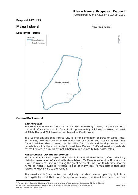
<strong>Mana</strong> <strong>Island</strong><br />
(recorded name)<br />
Locality of Porirua<br />
General Background<br />
The <strong>Proposal</strong><br />
The submitter is the Porirua City Council, who is seeking to assign a place name to<br />
the locality/island located in Cook Strait approximately 4 kilometres from the coast<br />
at Titahi Bay and 22 kilometres south-west of Kapiti <strong>Island</strong>.<br />
The Council advises that Porirua City is a conglomeration of parts of earlier local<br />
authorities, and as such inherited a number of suburb and locality names. The<br />
Council advises that it wants to formalise 22 suburb and locality names, and<br />
boundaries within the city in order to meet <strong>New</strong> <strong>Zealand</strong> Post’s addressing standards<br />
for mail, which in turn will attract substantial reductions to bulk postal rates.<br />
Research/History and References<br />
The Council’s website 1 reports that, ‘the full name of <strong>Mana</strong> <strong>Island</strong> reflects the long<br />
historical association of Maori with <strong>Mana</strong> <strong>Island</strong>. Te <strong>Mana</strong> o Kupe ki te Moana Nui a<br />
Kiwi (the mana of Kupe in crossing the great ocean of Kiwa), or its alternate shorter<br />
name Te <strong>Mana</strong> o Kupe ki Aoteroa, is one of many local Porirua names that also<br />
relates to Kupe's visit to the Porirua’.<br />
The website (ibid.) also notes that originally the island was occupied by Ngāi Tara<br />
and Ngāti Ira, and that since European settlement the island has been used for<br />
1 Porirua City Council, “History of <strong>Mana</strong> <strong>Island</strong>”, http://pcc.govt.nz/ (accessed 22 June 2010).<br />
01a NZGB - <strong>Proposal</strong> <strong>Report</strong> - <strong>Mana</strong> <strong>Island</strong> - 2010-08-03.doc, for meeting of 3 August 2010 Page 1 of 6<br />
File Ref: GES-N15-007-09/529
various purposes including an exotic sheep quarantine and breeding station, a cattle<br />
farm, and since 1987 the island has been managed by the Department of<br />
Conservation as a Scientific Reserve.<br />
Reed 2 records, ‘<strong>Mana</strong>: power, <strong>Mana</strong> <strong>Island</strong> near Wellington is in full, Te <strong>Mana</strong>-o-<br />
Kupe-ki-Aotea-roa, the ability of Kupe to cross the ocean to Aotearoa. It was Kupe’s<br />
daughter who suggested that the name should be given to the island.’<br />
Te Aka Māori-English, English- Māori Dictionary and Index 3 gives the essence of the<br />
meaning of ‘mana’ as ‘a supernatural force in a person, place or object’.<br />
The Northern tip of the island is the location of Matakitaki, a viewing place and burial<br />
ground originally named by Kupe. <strong>Mana</strong> <strong>Island</strong> contains other burial grounds such as<br />
the tomb of Waitohi, who was Te Rauparaha’s sister and the mother of Te<br />
Rangihaeata 4 . Kai Tangata, on the south-eastern side of the island, was the principal<br />
home of Te Rangihaeata until 1846. This was the site of his famous carved whare,<br />
Kai Tangata. Also on the south-eastern side of the island is Bell’s whaling station,<br />
which was run in conjunction with Te Korohiwa, located just south of Titahi Bay 5 . Te<br />
Ra Mariki is a highly tapu tauranga waka which was also located on the island. Te<br />
Rauparaha’s house was located on <strong>Mana</strong> <strong>Island</strong>, though the exact location is not<br />
known.<br />
The Board has previously acknowledged the full Maori name for the island feature as<br />
Te <strong>Mana</strong>-o-Kupe ki Te Moana-nui-a-Kiwa. However, <strong>Mana</strong> <strong>Island</strong> is the accepted<br />
shortened form.<br />
Location and Extent and Common/Long Term Usage of Locality<br />
The Council advises that the boundary lines follow land parcel boundaries and are<br />
based on historic records and current usage, and that where possible Statistics <strong>New</strong><br />
<strong>Zealand</strong> mesh block boundaries were followed.<br />
The Council advises that financial implications to residents required by changes to<br />
their addresses were considered, and were able to be reduced by focussing on<br />
formalising current usage and generally accepted geographic areas, rather than<br />
introducing new boundaries and names.<br />
<strong>Mana</strong> <strong>Island</strong> Scientific Reserve has been gazetted (see below) as an administrative<br />
area protected for scientific research.<br />
The proposed extent is rural in character. The website of Porirua City Council 6<br />
reports that the proposed extent is zoned ‘Rural’ for planning purposes.<br />
NZGB Act 2008 Definition of a Locality<br />
Under the terms of Section 4 of the NZGB Act 2008 a locality means ‘an identifiable<br />
area within a local authority area, usually rural or partly rural in character’.<br />
Board Guidelines<br />
It is particularly important that locality and suburb names and extents be assigned<br />
with emergency and utility services in mind. Therefore, emphasis on standardisation<br />
and non-ambiguity are the Board’s main concerns. When considering name proposals<br />
for localities or suburbs, the Board will:<br />
seek support of the relevant territorial authority before accepting a proposal for<br />
a locality or suburb name and extent<br />
consider local community views<br />
2 Reed, A.W., A Dictionary of Maori Place Names. (Wellington: AH & AW Reed, 1961)<br />
3 “Te Aka Māori-English, English- Māori Dictionary and Index” http://www.maoridictionary.co.nz/index.cfm<br />
(accessed 21 June 2010).<br />
4 Te Runanga o Toa Rangatira, Inc., Me Huri Whakamuri Ka Titiro Whakamua: A Framework for the <strong>Mana</strong>gement of<br />
Sites and Places of Significance<br />
to Māori within the Porirua District, 1996, 94 – 97.<br />
5 Day, Kelvin, <strong>Mana</strong> <strong>Island</strong>, Porirua Museum and Department of <strong>Land</strong>s and Survey, Porirua, 1987, 1.<br />
6 Porirua City Council, “Porirua City Council District Planning Zones”, http://pcc.govt.nz/ (accessed 13 May 2010).<br />
01a NZGB - <strong>Proposal</strong> <strong>Report</strong> - <strong>Mana</strong> <strong>Island</strong> - 2010-08-03.doc, for meeting of 3 August 2010 Page 2 of 6<br />
File Ref: GES-N15-007-09/529
take into account the views of tangata whenua.<br />
Media<br />
There has been some local media interest in the Council’s place name proposals, and<br />
the Council advises of an article, ‘Porirua May Adopt Māori Names’, which renewed<br />
public interest in the proposed names, and resulted in a one month extension to the<br />
consultation period. Other news articles are attached.<br />
Place Names Database (Archived) and NZ Gazetteer of Official Geographic<br />
Names<br />
The name <strong>Mana</strong> <strong>Island</strong> has not been gazetted as official through the NZGB Act;<br />
however, <strong>Mana</strong> <strong>Island</strong> Scientific Reserve, which has been validated as a Crown<br />
Protected Area (see NZ Gazette 2009 (73) p.1699), is included within the proposed<br />
boundary extent.<br />
The name <strong>Mana</strong> <strong>Island</strong> appears in the <strong>New</strong> <strong>Zealand</strong> Place Names Database<br />
(Archived) as a recorded name.<br />
NZGB Archive Records<br />
There are no archive records of the Board (Canterbury National, NZGB card indices)<br />
featuring the place name <strong>Mana</strong> <strong>Island</strong>.<br />
Historical Maps/Plans<br />
Cadastral and Topographic maps have shown the following through the years:<br />
Map Edition Name Survey Control Mark<br />
NZMS 1, N160 1, dated 1943 <strong>Mana</strong> <strong>Island</strong> 7404: <strong>Mana</strong><br />
NZMS 1, N160 2, dated 1952 <strong>Mana</strong> <strong>Island</strong> 7404: <strong>Mana</strong><br />
NZMS 1, N160 3, dated 1965 <strong>Mana</strong> <strong>Island</strong> 7404: <strong>Mana</strong><br />
NZMS 1, N160 4, dated 1977 <strong>Mana</strong> <strong>Island</strong> 7404: <strong>Mana</strong><br />
NZMS 13, WGN74 3, dated 1959 <strong>Mana</strong> <strong>Island</strong> 7404: <strong>Mana</strong><br />
NZMS 17, Porirua 1, dated 1958 Not depicted<br />
NZMS 17, Porirua 2, dated 1960 Not named<br />
NZMS 17, Porirua 3, dated 1966 Not depicted<br />
NZMS 17, Porirua 4, dated 1969 Not depicted<br />
NZMS 17, Porirua 5, dated 1972 Not depicted<br />
NZMS 177, N160 1, dated 1968 <strong>Mana</strong> <strong>Island</strong> 7404: <strong>Mana</strong><br />
NZMS 271, 1, dated 1976 <strong>Mana</strong> <strong>Island</strong> 7404: <strong>Mana</strong><br />
Porirua<br />
NZMS 271, 2, dated 1982 <strong>Mana</strong> <strong>Island</strong> 7404: <strong>Mana</strong><br />
Porirua<br />
NZMS 271, 3, dated 1987 <strong>Mana</strong> <strong>Island</strong> 7404: <strong>Mana</strong><br />
Porirua<br />
NZMS 271,<br />
Porirua<br />
4, dated 1995 <strong>Mana</strong> <strong>Island</strong><br />
NZMS 346, Te Ika<br />
a Māui<br />
1, dated 1995 Te <strong>Mana</strong> ō Kupe<br />
Ki Te Moana Nui<br />
a Kiwa<br />
Early survey plans show the following:<br />
Plan no. Date Name Survey Control Mark<br />
SO 10378 1862 <strong>Mana</strong> <strong>Island</strong><br />
SO 11047 1863 <strong>Island</strong> of <strong>Mana</strong><br />
SO 10659 1863 <strong>Island</strong> of <strong>Mana</strong><br />
SO 28923 1880 <strong>Mana</strong> Id<br />
SO 28924 1883 <strong>Mana</strong> Id<br />
SO 21558 1946 Not named 7404: <strong>Mana</strong><br />
SO 25776 1963 Not named 7404: <strong>Mana</strong><br />
SO 10445 Not dated <strong>Mana</strong> or Table<br />
<strong>Island</strong><br />
01a NZGB - <strong>Proposal</strong> <strong>Report</strong> - <strong>Mana</strong> <strong>Island</strong> - 2010-08-03.doc, for meeting of 3 August 2010 Page 3 of 6<br />
File Ref: GES-N15-007-09/529
Historical Miscellaneous plans/records<br />
Plan no. Date Name<br />
W(D)4 1844 <strong>Mana</strong><br />
W(D)135 1860 <strong>Mana</strong> <strong>Island</strong><br />
W(D)111 1871 <strong>Mana</strong> Id<br />
GAZ91 1875 <strong>Mana</strong> Is<br />
W(D)127 1878 <strong>Mana</strong> <strong>Island</strong><br />
G430 1927 <strong>Mana</strong> I<br />
Elsdon Best reference map Not dated (circa 1914?) <strong>Mana</strong> Isld<br />
Duplication<br />
The only duplication for the name ‘<strong>Mana</strong>’ is currently a suburb in Porirua; however,<br />
the Council has not presented a proposal to the Board to have the suburb name<br />
<strong>Mana</strong> formalised, as it was resolved by the Council that the suburb of Paremata<br />
subsume the area currently known as <strong>Mana</strong>.<br />
There are a number of streets and roads throughout <strong>New</strong> <strong>Zealand</strong> with the name of<br />
<strong>Mana</strong>. <strong>Mana</strong> Avenue, <strong>Mana</strong> Esplanade and <strong>Mana</strong> View Road are associative names<br />
with the locality:<br />
<strong>Mana</strong> Avenue<br />
Titahi Bay<br />
<strong>Mana</strong> Esplanade<br />
Porirua<br />
<strong>Mana</strong> Heights<br />
Nelson<br />
<strong>Mana</strong> Lane<br />
North Shore City<br />
<strong>Mana</strong> Place<br />
Manukau City; Napier; Palmerston North<br />
<strong>Mana</strong> Road<br />
<strong>New</strong> Plymouth; Stratford<br />
<strong>Mana</strong> Street<br />
Tauranga; Wellington<br />
<strong>Mana</strong> View Road<br />
Porirua<br />
James Fletcher Index of Māori names:<br />
The index of Māori names by Henry James Fletcher at the Waikato University website<br />
has the following entries for <strong>Mana</strong> <strong>Island</strong>:<br />
MANA An island in Cook's straits. A name in a song. J.P.S. 7:38-40; 10:110, 148; 13:8;<br />
16:159; 18:171, 172; 20:25; 22:126, 215; 23:13; 26:148; 154-161; 27:2, 103; 32:123;<br />
35:74, 160, 188; 38:292; 39:9; 67:68; 79:30; 105:273, 428, 436; 103:157. A.H.M.<br />
5:168; 6:36, 42, 144. S.D. 191. Ika. 259, 622. M.B. 6:16; 7:273. Trans. 1E:18; 2:160;<br />
3:131; 5:90; 30:35; 46:56; 48:430. W.W. 2:45-47, 61, 94, 118, 124, 133.<br />
MANA O<br />
KUPE<br />
MANA O<br />
KUPE KI<br />
AOTEAROA<br />
<strong>Mana</strong> island in Cooks strait. J.P.S. 23:177. See also <strong>Mana</strong>.<br />
<strong>Mana</strong> <strong>Island</strong>. W.W. 2:118 See <strong>Mana</strong> o Kupe<br />
Consultation with Neighbouring Territorial Authorities<br />
The Council has not provided documentary evidence of consultation with<br />
neighbouring Territorial Authorities, particularly those who may be affected by<br />
boundary extents. The Council advises in a letter dated 13 May 2010 that while no<br />
formal consultation has been undertaken with neighbouring authorities, day-to-day<br />
informal discussion and information exchanges do occur.<br />
In a letter dated 21 June 2010 the Board has sought the comments and views of the<br />
neighbouring Territorial Authorities, Wellington City Council, Hutt City Council, Upper<br />
Hutt City Council and Kapiti Coast District Council.<br />
On 1 July 2010 Wellington City Council responded that it supports Porirua City<br />
Council’s aim to clarify the names and boundaries of the suburbs within its<br />
boundaries.<br />
Consultation (including comment from Te Puni Kōkiri)<br />
The Council advises that it felt it was important that the community had an input on<br />
their understanding and acceptance of the areas in which they live and work. The<br />
01a NZGB - <strong>Proposal</strong> <strong>Report</strong> - <strong>Mana</strong> <strong>Island</strong> - 2010-08-03.doc, for meeting of 3 August 2010 Page 4 of 6<br />
File Ref: GES-N15-007-09/529
Council advises that a consultation document, “Where do you think you live”<br />
requesting feedback to the Council on the suburb and locality name proposals, was<br />
circulated to community groups and other interested parties and publicly notified,<br />
including being placed on the Council’s website and made available at the Council’s<br />
libraries. The submission period opened on 5 June 2009 and concluded at 5pm on 3<br />
July 2009, ie a month’s duration.<br />
The Council advises that it has a Charter of Understanding with Te Rūnanga o<br />
Ngatitoa Rangatira which acknowledges Ngāti Toa status as tangata whenua and<br />
mana whenua, and that their world-view is the Māori world-view of the city. The<br />
Council advises that in developing that world-view, it accepts that Ngāti Toa<br />
incorporate and articulate to the Council the position of broader Māori interests. The<br />
Council advises that two hui were held with Ngāti Toa who subsequently did not<br />
make a submission on the ‘Colonial Knob’ proposal.<br />
However, in terms of Sections 81 and 82 of the Local Government Amendment Act<br />
2002, the Council has not provided documentary evidence of consultation with other<br />
iwi who also have an interest in the Council’s local authority. While the Board has its<br />
own process for consultation with iwi, it does not substitute the Council’s legal<br />
obligations under the Local Government Amendment Act 2002.<br />
Te Puni Kōkiri may provide further feedback at the Board meeting.<br />
The Council advises that while no specific submissions were received from the public<br />
for the <strong>Mana</strong> <strong>Island</strong> proposal, three submissions proposed that macrons should be<br />
placed on Māori place names where applicable.<br />
Views of the Public<br />
The Council advises that contact from the community had highlighted the ad-hoc<br />
way in which suburbs had been named, and that the boundaries existing between<br />
suburban areas had been non-existent or had become blurred as the city expanded<br />
geographically. No adverse response appears to have emerged from the community.<br />
If the Board proceeds with public notification of this locality name proposal, then an<br />
opportunity exists for any objections to be submitted.<br />
Views of the Porirua City Council<br />
The Council advises that historically its suburbs and localities were able to be<br />
relatively clearly identified, as a suburb name normally referred to one urban area,<br />
and was isolated from another by rural land; however, the Council advises that<br />
developers have tended to create new names to market new subdivisions, which<br />
causes confusion.<br />
The Council advises that as no submissions were received for the proposal to assign<br />
the name <strong>Mana</strong> <strong>Island</strong> during its consultation period, it was resolved by Council<br />
members that the original proposal stand.<br />
Lessons from Processing the North Shore City Council Suburb Names<br />
In November 2004 the Board received a proposal from North Shore City Council to<br />
name 44 suburbs in North Shore City; however, no documentary evidence from<br />
emergency services, NZ Post or neighbouring Territorial Authorities was provided to<br />
support the proposals, and no consultation was carried out in terms of Sections 81<br />
and 82 of the Local Government Amendment Act 2002.<br />
In the ensuing years between 2004 and 2007, when the suburbs within North Shore<br />
City were eventually notified as proposals, a level of frustration was felt by the Board<br />
because of lack of documentary evidence of consultation by the Council.<br />
Emergency Services and NZ Post<br />
The Council advises that the need to formalise suburbs and localities within its<br />
jurisdiction was instigated by a recent change to <strong>New</strong> <strong>Zealand</strong> Post’s addressing<br />
requirements for mail. To attract substantial reductions in bulk postal rates, the<br />
01a NZGB - <strong>Proposal</strong> <strong>Report</strong> - <strong>Mana</strong> <strong>Island</strong> - 2010-08-03.doc, for meeting of 3 August 2010 Page 5 of 6<br />
File Ref: GES-N15-007-09/529
addresses held in the Council’s various databases are required to meet NZ Post’s<br />
addressing standards, and be regularly certified to meet those standards.<br />
The Council has not provided documentary evidence of consultation with NZ Post;<br />
however, the Council advises that discussions with NZ Post have been ongoing for a<br />
number of years in relation to addressing and boundary issues, and once the place<br />
names and boundaries are formalised, they will advise NZ Post of any changes<br />
required to their databases.<br />
The Council has not provided documentary evidence of consultation with emergency<br />
services; however, the Council advises that a copy of the consultation document was<br />
provided to Police, Fire and Ambulance, but no response was received. It may be<br />
important for safety reasons that the suburb is officially named on maps.<br />
In general the comparison of names between Porirua City Council and Emergency<br />
Services (Police, Fire, Ambulance and Civil Defence) reveals differences. However,<br />
the Emergency Services names and boundary definitions are not publicly available<br />
and were compiled by those agencies to meet internal operational needs for<br />
responding to incidents. It is understood that Emergency Services consulted with<br />
some Territorial Authorities at the time of their compilation around mid-2005.<br />
For <strong>Mana</strong> <strong>Island</strong>, Emergency Services follows an identical boundary extent as that<br />
proposed by the Council.<br />
In the future the rationalisation between Emergency Services, Territorial Authorities,<br />
NZ Post and the Board is an outcome that is being sought for upholding consistency<br />
and standardisation so as to eliminate confusion and ambiguity.<br />
The Council advises that Civil Defence is a Council function and has been involved in<br />
the formalisation of the suburb and locality names from an early stage.<br />
Spelling/Orthography, including Te Taura Whiri i te Reo Māori (Māori<br />
Language Commission) advice re Māori names<br />
The observer from Te Taura Whiri i te Reo Māori has commented that ‘mana’<br />
possibly means ‘shrimp’.<br />
01a NZGB - <strong>Proposal</strong> <strong>Report</strong> - <strong>Mana</strong> <strong>Island</strong> - 2010-08-03.doc, for meeting of 3 August 2010 Page 6 of 6<br />
File Ref: GES-N15-007-09/529


