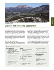
A Guide To Paddling in the Big South Fork - National Park Service
A Guide To Paddling in the Big South Fork - National Park Service
A Guide To Paddling in the Big South Fork - National Park Service

Create successful ePaper yourself
Turn your PDF publications into a flip-book with our unique Google optimized e-Paper software.
River Levels<br />
5000 CFS:<br />
At this level, <strong>the</strong> river changes character. Waves <strong>in</strong> <strong>the</strong><br />
6-8 foot category are common, with a few atta<strong>in</strong><strong>in</strong>g 10<br />
feet <strong>in</strong> height. Some eddies are very unstable, and<br />
waves beg<strong>in</strong> to pulse. Diagonal reactionary waves are<br />
common <strong>in</strong> <strong>the</strong> gorge and make upright boat<strong>in</strong>g cont<strong>in</strong>uously<br />
difficult. Equipment is frequently lost if not<br />
retrieved expeditiously. River classification: Class IV.<br />
10,000 CFS:<br />
Clear <strong>Fork</strong> has roll<strong>in</strong>g 4-5 foot waves for much of its<br />
length. The Little Three is a solid Class IV plus with<br />
large reactionary waves for 1/2 mile. The ma<strong>in</strong> gorge<br />
resembles <strong>the</strong> New River Gorge at medium water<br />
levels. Waves are huge, especially <strong>in</strong> <strong>the</strong> <strong>Big</strong> Three and<br />
<strong>the</strong> canyon sections. The canyon is very dangerous at<br />
this level because it is cont<strong>in</strong>uous for 1-1/2 miles with<br />
only a few eddies. The waves <strong>in</strong> <strong>the</strong> ma<strong>in</strong> current<br />
average 7 - 8 feet. The water is up <strong>in</strong> <strong>the</strong> brush and<br />
trees <strong>in</strong> places, thus mak<strong>in</strong>g rescue extremely difficult<br />
and broaches a possibility. Several giant holes appear<br />
which can be extremely dangerous, e.g., Krekels<br />
(Honey Creek Rapid). Above 10,000 CFS <strong>the</strong>re is a<br />
river wide hole between <strong>the</strong> EL and <strong>the</strong> Honey Creek<br />
Rapids, caution is advised. River classification: Class<br />
IV - V.<br />
20,000 CFS:<br />
The river has a similar character to levels around<br />
10,000 CFS. Holes become bigger and meaner. Waves<br />
beg<strong>in</strong> to explode irregularly. River debris (logs and<br />
trees) become a factor. Most rapids <strong>in</strong> <strong>the</strong> gorge are<br />
over 1/4 mile long. Swims are likely to be life-threaten<strong>in</strong>g<br />
to <strong>the</strong> swimmer and <strong>the</strong> rescuer. Rescue of equipment<br />
is almost too difficult. This level is considered<br />
high flood, and much of <strong>the</strong> gorge is Class V. Walkouts<br />
are common at this level. Overnight stays may be<br />
<strong>the</strong> result. River classification: Class V.<br />
40,000 CFS:<br />
The Little Three has 8 - 9 foot waves. The <strong>Big</strong> Three is<br />
a mile-long Class V with cont<strong>in</strong>uous 10 - 15 foot erratic<br />
(reactionary) waves term<strong>in</strong>at<strong>in</strong>g <strong>in</strong> a river-wide hole at<br />
Honey Creek Rapid. The Canyon is a 1-1/2 mile CON-<br />
TINUOUS series of 12 - 15 foot reactionary wave tra<strong>in</strong>s<br />
with several offset holes, one of which is 2/3 of <strong>the</strong> river<br />
wide and probably a keeper. Float<strong>in</strong>g river debris is<br />
very problematic. Walk-outs are very likely. River<br />
classification: Class V plus.