

Exploring the Neogene history of the Columbia River - Oregon ...
Exploring the Neogene history of the Columbia River - Oregon ...
Exploring the Neogene history of the Columbia River - Oregon ...

You also want an ePaper? Increase the reach of your titles
YUMPU automatically turns print PDFs into web optimized ePapers that Google loves.
ange from O.S {O2 cm in size. You may want to collect a<br />
small, fresh piece <strong>of</strong> this flow (with a glomerocryst if you<br />
can) to compare to mher <strong>Columbia</strong> <strong>River</strong> basalt flows you<br />
will see on this trip. Based on surface exposure and subsurface<br />
data from an <strong>Oregon</strong> Depanment <strong>of</strong> Geology and<br />
Mineral Industries (DOGAMI) heat-flow well drilled in<br />
this quarry, this flow is approllimately SO m thick. The<br />
great thickness <strong>of</strong> this flow and <strong>the</strong> presence <strong>of</strong> scanered<br />
pillowed zones throughoUi <strong>the</strong> exposure suggesl that it may<br />
be an intracanyon flow.<br />
[1.4] Tum onlO /-84 eastbound toward Hood <strong>River</strong>. Nz high MgO<br />
Grande Ronde flows arc ellposed along <strong>the</strong> railroad track<br />
from here to <strong>the</strong> railroad tunnel. Crown Point is <strong>the</strong> prominence<br />
to <strong>the</strong> right, Roosler Rock is <strong>the</strong> pinnacle to <strong>the</strong> left.<br />
[3.4] Base <strong>of</strong> Crown Point. SlOp at <strong>the</strong> gate on <strong>the</strong> right directly<br />
acrossfrom Rooster Rock (0.2 mi past milepost 24). Do not<br />
block <strong>the</strong> gate. From <strong>the</strong> road you can see <strong>the</strong> Priest Rapids<br />
hyaloclastite below <strong>the</strong> Priest Rapids intracanyon flow. You<br />
may also walk over to <strong>the</strong> base <strong>of</strong> Crown Point for a bener<br />
view, but watch out for poison oak and trains. Crown Point<br />
is an excellent exposure <strong>of</strong> <strong>the</strong> thick Priest Rapids (Rosalia<br />
chemical type) intracanyon now overlying a bedded<br />
hyaloclastile (also Rosalia chemical type). If you walk over<br />
to <strong>the</strong> base <strong>of</strong> Crown Point, collect a small, fresh sample <strong>of</strong><br />
<strong>the</strong> Priest Rapids flow and hyaloclastite to compare to<br />
samples from ellposures <strong>of</strong> this same flow at Stops 13 and<br />
IS. The lack <strong>of</strong> pillows al <strong>the</strong> lavalhyaloclastite contact<br />
suggests that <strong>the</strong> hyaloclastite was not excessively wet<br />
when <strong>the</strong> lava flowed over it. The combined thickness <strong>of</strong> <strong>the</strong><br />
lava flow and hyaloclastite ellceeds 215 m. A few large,<br />
subangular boulders <strong>of</strong> <strong>Columbia</strong> Ri ver basalt and<br />
~Skamania Volcanics~ suggest flood or lahar transpon.<br />
Note <strong>the</strong> graded bedding, local cross-bedding, and <strong>the</strong><br />
degree <strong>of</strong> rounding <strong>of</strong> <strong>the</strong> clasts in <strong>the</strong> hyaloclastite seen<br />
here and compare this outcrop to <strong>the</strong> massive Rosalia<br />
hyaloclastite exposure at Stop IS . Continue east on /-84.<br />
[3.8] Rooster Rock exit. Take Rooster Rock exit (Exit 25), cross<br />
ol"er freeway, tum left before park entrance, and proceed<br />
west on /-84.<br />
[6 .91 Take Exit 22 to Corbett to return to main part <strong>of</strong> trip log.<br />
[8.6) Interseclion with Old Scenic Highway (mile point 6.9 <strong>of</strong><br />
main trip). Thrn left toward Crown Point to resume main<br />
trip route.<br />
END OF OPTIONAL SIDE TRIP A<br />
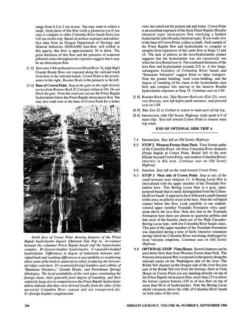
North face <strong>of</strong> Crown Point showing features <strong>of</strong> <strong>the</strong> Priest<br />
Rapids hyaloclastite deposit (Optional Side Trip Ii). A=contact<br />
between <strong>the</strong> columnar Priest Rapids basalt and <strong>the</strong> hyaloclastite<br />
complex. B=foreset-bedded hyaloclastite. C=parallel-bedded<br />
hyaloclastite. Differences in degree <strong>of</strong> induration between individual<br />
beds and resulting differences in susceptibility to wea<strong>the</strong>ring<br />
allow some <strong>of</strong> <strong>the</strong> beds to stand out in relief, producing <strong>the</strong> horizontal<br />
ridges seen here. D=scatteredforeign boulders and cobbles <strong>of</strong><br />
·Skamania Volcanics,· Grande Ronde, and Frenchman Springs<br />
lithologies. The local availability <strong>of</strong> <strong>the</strong> rock types constituting <strong>the</strong><br />
foreign clasts, <strong>the</strong>ir generally poor degree <strong>of</strong>rounding, and <strong>the</strong>ir<br />
relatively large size in comparison to <strong>the</strong> Priest Rapids hyaloclastic<br />
debris indicate that <strong>the</strong>y were derived locally from <strong>the</strong> sides <strong>of</strong> <strong>the</strong><br />
ancestral <strong>Columbia</strong> <strong>River</strong> canyon and not transported for.<br />
E=foreign boulder conglomerate.<br />
7.4 Inlerseclion. Stay left on Old Scenic Highway.<br />
8.5 STOP 2. Womens Forum State Park. View former paths<br />
<strong>of</strong> <strong>the</strong> <strong>Columbia</strong> <strong>River</strong>. All three <strong>Columbia</strong> <strong>River</strong> channels<br />
(Priest Rapids at Crown Poinl, Bridal Veil in <strong>the</strong> next<br />
hillside beyond Crown Point, and modern <strong>Columbia</strong> Ri ve r)<br />
intersect in this area. Cominue east on Old Scenic<br />
Highway.<br />
9.0 Junction. Stay left on <strong>the</strong> road toward Crown Point.<br />
9.3 STOP 3. West side <strong>of</strong> Crown Point. Stop at any <strong>of</strong> <strong>the</strong><br />
small turnouts near milepost 11. A Bori ng Lavas flow is<br />
intercalated with Ihe upper member <strong>of</strong> <strong>the</strong> Troutdale Formation<br />
here. This Boring Lavas flow is a gray, opentextured<br />
basalt that is easily distinguished from Ihe <strong>Columbia</strong><br />
<strong>River</strong> basalt. It appears 10 have followed a small channel<br />
in this area; no pi llows occur at <strong>the</strong> base. Note <strong>the</strong> red baked<br />
contact below Ihis flow. Look carefully to see reddishcolored<br />
upper member Troutdale Formation vitric sandstone<br />
above <strong>the</strong> lava flow. NOie also that in <strong>the</strong> Troutdale<br />
Formation here <strong>the</strong>re are almost no quanzite pebbles and<br />
that most <strong>of</strong> <strong>the</strong> basaltic clasts are <strong>of</strong> <strong>the</strong> High Cascades<br />
Boring Lavas type, with few <strong>Columbia</strong> <strong>River</strong> basalt clasts.<br />
This pan <strong>of</strong> <strong>the</strong> upper member <strong>of</strong> <strong>the</strong> Troutdale Formation<br />
was deposited during a time <strong>of</strong> fairly intensive volcanism<br />
during which <strong>the</strong> <strong>Columbia</strong> <strong>River</strong> was being challenged by<br />
local volcanic eruptions. Continue east on Old Scenic<br />
Highway.<br />
9.8 OPTIONAL STOP. Vista House. Several features can be<br />
seen better here than from Womens Forum State Park. The<br />
Pomona intracanyon flow is exposed in <strong>the</strong> quarry along <strong>the</strong><br />
railroad tracks on <strong>the</strong> Washington side <strong>of</strong> <strong>the</strong> ri ver. The<br />
Bridal Veil channel on <strong>the</strong> <strong>Oregon</strong> side <strong>of</strong> <strong>the</strong> river lies just<br />
east <strong>of</strong> Ihe Bridal Veil exit from <strong>the</strong> freeway. Here at Vista<br />
House on Crown Point you are standing directly on top <strong>of</strong><br />
<strong>the</strong> Priest Rapids intracanyon flow, more than 215 m above<br />
<strong>the</strong> forme r canyon bottom (ISS m <strong>of</strong> lava flow on top <strong>of</strong><br />
more than -60 m <strong>of</strong> hyaloclastite). Note <strong>the</strong> Boring Lavas<br />
shield volcanoes above <strong>the</strong> cliffs <strong>of</strong> <strong>Columbia</strong> <strong>River</strong> basalt<br />
on both sides <strong>of</strong> <strong>the</strong> river.<br />
104<br />
OREGON GEOLOGY, VOLUME 46, NUMBER 9, SEPTEMBER 1984


