

Ore Bin / Oregon Geology magazine / journal - Oregon Department ...
Ore Bin / Oregon Geology magazine / journal - Oregon Department ...
Ore Bin / Oregon Geology magazine / journal - Oregon Department ...
- No tags were found...

You also want an ePaper? Increase the reach of your titles
YUMPU automatically turns print PDFs into web optimized ePapers that Google loves.
OREGON GEOLOGY<br />
formerly THE ORE BIN<br />
published by the <strong>Ore</strong>gon <strong>Department</strong> of <strong>Geology</strong> and Mineral Industries<br />
VOLUME 42 , NUMBER 8 AUGUST 1980
OREGON GEOLOGY<br />
(lSSN 0164·3304)<br />
VOLUME 42, NUMBER 8 AUGUST 1980<br />
Published monthly by the State of <strong>Ore</strong>gon <strong>Department</strong> of<br />
<strong>Geology</strong> and Mineral Industries (Volumes I through 40 were entitled<br />
The <strong>Ore</strong> <strong>Bin</strong>).<br />
Governing Board<br />
John L. Schwabe, Chairman .................... Portland<br />
Robert W. Doty. . . . . . . . . . . . . . . . . . . . . . . . . . . . . . . .. Talent<br />
C. Stanley Rasmussen. . . . . . . . . . . . . . . . . . . . . . . . . . .. Baker<br />
State Geologist. . . . . . . . . . . . . . . . . . . . . . . . . . . .. Donald A. Hull<br />
Deputy State Geologist. . . . . . . . . . . . . . . . . . . . .. John D. Beaulieu<br />
Editor .................................... Beverly F. Vogt<br />
Main Office: 1069 State Office Building, Portland 97201, phone<br />
(503) 229-5580.<br />
Baker Field Office: 2033 First Street, Baker 97814, phone (503)<br />
523-3133.<br />
Howard C. Brooks, Resident Geologist<br />
Grants Pass Field Office: 312 S.E. "H" Street, Grants Pass 97526,<br />
phone (503) 476-2496.<br />
Len Ramp, Resident Geologist<br />
Mined Land Reclamation Program: 1129 S.E. Santiam Road, Albany<br />
97321, phone (503) 967-2039.<br />
Paul F. Lawson, Supervisor<br />
Micropaleontological data from<br />
five oil and gas wells released<br />
The <strong>Ore</strong>gon <strong>Department</strong> of <strong>Geology</strong> and Mineral<br />
Industries (DOGAMI) has released micropaleontological<br />
data on samples from five oil and gas test holes<br />
drilled along the west side of the Willamette Valley as<br />
Open-File Report 0-80-1, Micropaleontological Study<br />
of Five Wells, Western Willamette Valley, <strong>Ore</strong>gon. The<br />
work was performed by Daniel R. McKeel, Consulting<br />
Micropaleontologist, under contract to DOGAMI.<br />
The five wells selected for micropaleontological<br />
study, located between Forest Grove to the north and<br />
Albany to the south, are Texaco Cooper ~ountain 1,<br />
Reichhold Merrill 1, Reichhold Finn 1, Reserve Bruer 1,<br />
and Humble Miller 1. Geologic ages (foraminiferal<br />
stages) have been assigned by McKeel to rock units<br />
penetrated in the wells. Paleoenvironments are also indicated.<br />
Results of the micropaleontological work will<br />
be useful for future geologic investigations of the area<br />
and western <strong>Ore</strong>gon.<br />
Copies of Open-File Report 0-80-1 may be purchased<br />
for $2.00. Address orders to the <strong>Ore</strong>gon <strong>Department</strong><br />
of <strong>Geology</strong> and Mineral Indu~tries, 1069 State Office<br />
Building, Portland, OR 97201. Payment must accompany<br />
orders of less than $20.00. 0<br />
Subscription rates: I year, $4.00; 3 years, $10.00. Single issues,<br />
$.40 at counter, $.50 mailed.<br />
Available back issues of The <strong>Ore</strong> <strong>Bin</strong>: $.25 at counter, $.50<br />
mailed.<br />
Address subscription orders, renewals, and changes of address to<br />
<strong>Ore</strong>gon <strong>Geology</strong>, 1069 State Office Building, Portland, OR<br />
97201.<br />
Send news, notices, meeting announcements, articles for<br />
publication, and editorial correspondence to the editor, Portland<br />
office. The <strong>Department</strong> encourages author-initiated peer review<br />
for technical article~ prior to submission. Any review should be<br />
noted in the acknowledgments.<br />
Permission is granted to reprint information contained herein.<br />
Credit given to the <strong>Ore</strong>gon <strong>Department</strong> of <strong>Geology</strong> and Mineral<br />
Industries for compiling this information will be appreciated.<br />
Second class postage paid at Portland, <strong>Ore</strong>gon.<br />
Postmaster: Send address changes to <strong>Ore</strong>gon <strong>Geology</strong>, 1069<br />
State Office Building, Portland, OR 97201.<br />
CONTENTS<br />
Deposition and deformation of the Eocene<br />
Umpqua Group, Sutherlin area, southwestern<br />
<strong>Ore</strong>gon ................................... 135<br />
A personal account of a nuee ardente on Mount<br />
St. Helens during the eruption of May 18,1980 .. 141<br />
New geology glossary adds 3,000 terms .......... 144<br />
Types of scientific studies conducted on Mount St.<br />
Helens, July 1980 .......................... 144<br />
USGS bibliography of continental shelf and coastal<br />
zone available ............................. 144<br />
The gold dredge at Whiskey Run north of the<br />
mouth of the Coquille River, <strong>Ore</strong>gon. . . . . . . . .. 145<br />
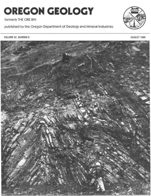
COVER PHOTO<br />
Chevron folds in Roseburg Formation exposed<br />
in roadcut on east bank of Umpqua River<br />
immediately east of Woodruff Mountain in southwestern<br />
<strong>Ore</strong>gon (see article beginning next page).<br />
These folds may be associated with a branch of the<br />
Bonanza fault. Photo courtesy Ewart Baldwin.<br />
Send us your new address<br />
When you move, don't forget to send your new address<br />
to the <strong>Ore</strong>gon <strong>Department</strong> of <strong>Geology</strong> and Mineral<br />
Industries.<br />
134<br />
OREGON GEOLOGY, VOL. 42, NO.8, AUGUST 1980
Deposition and deformation of the Eocene Umpqua<br />
Group, Sutherlin area, southwestern <strong>Ore</strong>gon<br />
by R.K. Perttu, Bear Creek Mining Company, Spokane. Washington 99213, and<br />
G. T. Benson. Earth Sciences Depamnenr, Portland Stale UniversilY, Portland, <strong>Ore</strong>gon 97207<br />
ABSTRACT<br />
The lower [0 middle Eocene Umpqua Group,<br />
5.000·10,000 m (16,500-33.000 ft) thick. exposed north<br />
of Roseburg, <strong>Ore</strong>gon, consists of basal tholeiitic basah<br />
overlain by a thick turbidite sequence and succeeding<br />
interbedded silt stone, sandstone, and conglomerate, all<br />
involved in northeast-trending folds with local, intensely<br />
deformed lones. In cOnlrast, the middle Eocene<br />
Tyee Formation, mainly thick-bedded sandstone, of the<br />
Coast Range to the west and the upper Eocene and<br />
younger andesitic volcanic rocks of the Cascade Range<br />
to the east are only slightly deformed around generally<br />
north-trending axes. Lithology and current directions<br />
suggest contemporaneity of deposition and devdopment<br />
of the Umpqua Group structures in the Roseburg<br />
Sutherlin area. Here the Umpqua Group represents the<br />
slope development of an accreting continental margin<br />
followed by shelf deposits of the Tyee formation.<br />
INTRODUCTION<br />
Marine sedimentary and basaltic volcanic rocks of<br />
the lower to middle Eocene Roseburg and Lookingglass<br />
formations crop out in a broad, north-trending belt<br />
north of Roseburg, <strong>Ore</strong>gon (figure I). This belt is<br />
bounded on the west and north by the slightly younger<br />
middle Eocene flournoy and Tyee formations which<br />
form most of the southern <strong>Ore</strong>gon Coast Range, on the<br />
east by upper Eocene and younger andesitic volcanic<br />
and associated rocks of the western Cascade Range, and<br />
on the south by pre-Tertiary rocks of the nonhern<br />
Klamath Mountains. St ructures in the Roseburg Formation<br />
are large, northeast-trending, faulted folds that<br />
parallel the pre-Tertiary grain in the northernmost<br />
Klamath Mountains. These Roseburg Formation structures<br />
are quite different from the open, north-trending<br />
nexures ilt the slightly younger Eocene formations of<br />
the Coast and Cascade Ranges. Sedimentary structu res<br />
and facies distribution suggest that deformation of the<br />
Umpqua Group was necessarily almost contemporaneous<br />
wit h its deposition, and the two processes must have<br />
been interrelated. furthermore, the changes in lithology<br />
and structural trends from the Roseburg formation to<br />
younger units suggest a transition from an active continental<br />
slope to a more stable shelf environment.<br />
STRA TIGRAPHV<br />
The pre-Tertiary units of the Klamath Mountains<br />
crop out south of the Sutherlin area and may partially<br />
underlie it. These Klamath Mountains un its include<br />
OREGON GEOLOGY, VOl .. 42, NO.8, AU(;UST 1980<br />
Jurassic and Cretaceous graywacke, conglomerate,<br />
mudstone, and volcanic rocks, which are generally<br />
sheared and/or metamorphosed, with local pods of<br />
chert and blueschist and bodies of serpentinite (Ramp,<br />
1972), all wi th a strong, northeast-trending structural<br />
grain. Successively younger units in the Sutherlin area<br />
are the Roseburg, Lookingglass, and Flournoy Formations<br />
(Umpqua Group); the Tyee Formation; and the<br />
volcanogenic rocks of the Western Cascade suite.<br />
Umpqua Group<br />
The Umpqua Formation was defi ned by Diller<br />
(1898) as a thick Eocene sequence consisting predominantly<br />
of thin-bedded alternating sandstone and shale<br />
overlying and interfingering with volcanic rocks.<br />
Baldwin (1965, 1974, 1975) subdivided the Umpqua into<br />
the Roseburg, Lookingglass, and Flournoy Formations,<br />
permitting elevation of the Umpqua to group status<br />
(Thoms, 1975). Baldwin (1974) included the volcanic<br />
rocks in the Roseburg Formation but distinguished<br />
them on his map; Thoms (1975) referred them to the<br />
"Siletz River Formation." We have chosen to call these<br />
volcanic rocks Roseburg basalt, following Baldwin.<br />
Roseburg basalt: Basaltic volcanic rocks, mainly<br />
pillow lavas and zeolitized breccia with an aggregate<br />
thickness of up to 2,000 m (6,600 ft) or more, form the<br />
basal unit of the Umpqua Group in the Roseburg area<br />
(Baldwin, 1974). The volcanic rocks interfinger with<br />
and are overlain by Umpqua Group sedi mentary rocks<br />
(including units younger than the Roseburg Formation)<br />
in cores of structural highs as fa r north as Drain (Figure<br />
2). The Roseburg basalt is tholeiitic, similar to the lower<br />
part of the Siletz Ri ver Volcanics of early to middle<br />
Eocene age in the northern <strong>Ore</strong>gon Coast Range<br />
(Snavely and others, 1968). The basalt is not everywhere<br />
present at the base of the Umpqua Group (Figure I).<br />
Roseburg .'ormalion: The lower sedimentary unit<br />
of the Umpqua Group, the Roseburg Formation, includes<br />
sandstone, siltstone, mudstone, and minor conglomerate.<br />
In the Sutherlin area, the Roseburg sedimentary<br />
section is at least 2,500 m (8,000 ft) thick and consists<br />
predominantly of rhyt hmically alternating graywacke<br />
and mudstone beds. Most of the sandstone beds<br />
were deposited by turbidity currents. Graded bedding is<br />
common, with some beds containing more than one<br />
grading unit, and scour structures and bioturbation are<br />
evident. Conglomerate occurs mainly near the Roseburg<br />
basalt, which was the primary source of the clasts. In<br />
general, the rat io of sandstone to siltstone in the<br />
Roseburg Formation decreases northward, away from<br />
the presu med source area.<br />
'35
LEGEND<br />
[',TtJ<br />
_.~C ,<br />
Cascade Volcanic<br />
rocks<br />
UeU<br />
Tyee Formation and<br />
younger marine<br />
sedimentary units<br />
B<br />
Umpqua Group<br />
[(eU:b]<br />
Roseburg Basa t t<br />
[ill]]<br />
Pre-Tertiary<br />
OREGON<br />
CAL I FORN I A<br />
o 10 20 MILES<br />
L . ===::J<br />
20 40 KM<br />
W b---, ~d<br />
Figure 1, Regional geologic map of southwestern <strong>Ore</strong>gon showing Umpqua Group and adjacent<br />
major rock units (modified from Wells and Peck, 1961, and Baldwin, 1976),<br />
Lookingglass Formation: In its type area, southwest<br />
of Roseburg, Baldwin (1974) has subdivided the<br />
Lookingglass Formation into three members: basal conglomerate<br />
and sandstone, middle siltstone and sandstone,<br />
and upper sandstone and conglomerate, Further<br />
south, where the Lookingglass oversteps the pre<br />
Tertiary, the middle unit becomes coarser; locally, it<br />
pinches out and interfingers with the upper and lower<br />
members. To the north, the Lookingglass, like the Roseburg,<br />
becomes finer grained, and the basal Lookingglass<br />
conglomerate is only locally present, as at<br />
Woodruff Mountain (Figure 2),<br />
Clasts in the Lookingglass conglomerate include a<br />
variety of plutonic and metamorphic rock types apparently<br />
derived from Klamath Mountains terranes, in contrast<br />
to the predominant basalt pebbles in the Roseburg<br />
136<br />
OREGON GEOLOGY, VOL. 42, NO.8, AUGUST 1980
D<br />
GEOLOGIC UNITS<br />
Basal t ic<br />
intrusives r-<br />
Te r '-<br />
Cascade volcanic 1~1<br />
Tef<br />
rocks ~ I~~I<br />
A .:1/<br />
Tyee Fm. and /. .... +7f--Te rb<br />
y ounlle r rna r i ne __/+~·+__.I1 ~<br />
S e ~ i me n tar y (+..:~Y-- / Te ~\-_AI!.~~-N<br />
un t t s '\. ",/ / _~_--"...._<br />
- 1>"4 \ .. 1>.::,)<br />
ry;;;-l<br />
I<br />
Umpqua Group<br />
II +,\) +., .:t~__<br />
~ /I,\?."·· +/<br />
// A- •••• + ......__...._./<br />
rTefI Flournoy<br />
~ Formation<br />
~ Lookinllillass<br />
~ Formation<br />
Roseburg<br />
Formation<br />
Roseburg<br />
Ba sa It<br />
/;4. ... ~/<br />
-4:.:..;/<br />
LEGEND<br />
Figure 2. Regional geologic map of the Sutherlin area, <strong>Ore</strong>gon (modified from Ramp,<br />
1972, and Baldwin, 1974).<br />
conglomerate. Lookingglass sandstone beds are generally<br />
not graded and, especially to the south, are characterized<br />
by fossil assemblages (Baldwin, 1975) suggestive<br />
of a shallower depositional environment. The Lookingglass<br />
conglomerate at Woodruff Mountain may represent<br />
a channel filling on the continental shelf or upper<br />
slope.<br />
As a rule, lithology is more consistent in the Look-<br />
ingglass Formation than it is in the Roseburg Formation;<br />
deformation is less intense, with decreasing deformation<br />
upward in the formation, and dips are gentler. A<br />
regional difference in attitudes has been shown by<br />
Girard (1962). Local steep dips in the lower part of the<br />
Lookingglass Formation probably mark the dying<br />
phases of the Roseburg-style deformation.<br />
Flournoy Formation: West of Roseburg, the Flour-<br />
OREGON GEOLOGY, VOL. 42, NO.8, AUGUST 1980<br />
137
noy Formation is about 900 m (3,000 ft) thick and includes<br />
a lower unit composed of sandstone and lesser<br />
siltstone and an upper unit composed of alternating<br />
beds of sandstone and siltstone (Baldwin, 1974). To the<br />
south, the Flournoy sandstone becomes coarser grained,<br />
thicker, and lithologically very similar to the overlying<br />
Tyee Formation. To the north, the Flournoy Formation<br />
is fin er grained, which is consistent with the regional<br />
fa cies patterns in the Umpqua Group.<br />
Tyee Formation<br />
Resistant sandstone beds of the Tyee Formation<br />
form ridges of the southern <strong>Ore</strong>gon Coast Range. In its<br />
southern facies (lovell, 1969), the Tyee Formation is up<br />
to 1,500 m (5,000 ft) thick and consists principally of<br />
thick-bedded sandstone with lesser siltstone and pebble<br />
conglomerate. The sandstone is typically medium- to<br />
coarse-grained, micaceous, lithic to feldspathic graywacke.<br />
Cross-bedding and channeling, plant remains,<br />
and coal lenses are common. To the north, bedding<br />
becomes thinner and rhyt hmic, the ratio of sand to silt<br />
decreases (Baldwin, 1975), and foss ils are not found<br />
(Thoms, 1975). This transition suggests a change from<br />
delta to shelf and perhaps marginal basin facies.<br />
Dips in the Tyee Formation are gentle. In particular,<br />
the beds exposed in the long Tyee escarpment west<br />
of Sutherlin do not reflect either the northeasterly<br />
trends or the degree of deformation found in the<br />
underlying Roseburg and Lookingglass Format ions<br />
(Figure 2).<br />
Volcanic units of the Western Cast::ade Range<br />
late Eocene and younger volcanic and volcaniclastic<br />
rocks of the western Cascade Range overlie Tyee,<br />
Umpqua, and pre-Tertiary units east of Sutherlin and<br />
Roseburg (Figures I and 2). The predominantly andesitic<br />
Cascade rocks generally dip gently eastward into a<br />
pile thousands of meters thick.<br />
A few sills and dikes of basaltic composition cut the<br />
Eocene rocks east of Sutherlin and Roseburg (Figure 2).<br />
These intrusions may be as old as late Eocene or as<br />
young as Miocene.<br />
CURRENT DIRECTIONS<br />
Current directions in the Roseburg Formation and<br />
in the Flournoy and Tyee Formations, as shown in<br />
Figure 2 and plotted in half-rose diagrams in Figure 5,<br />
are markedly different. Directions in the Roseburg Formation,<br />
based on scour marks (groove and flute casts,<br />
bounce and prod marks), show that the turbidity flows<br />
were mainly from the east. In contrast, Flournoy and<br />
Tyee cu rrents (data mainly from Snavely and others,<br />
1964) flowed northward from the Klamath Mountains<br />
province. Only Flournoy and Tyee current directions<br />
appearing on the map (Figure 2) are shown in the halfrose<br />
diagram (Figure 5); if all of the data of Snavely and<br />
others (1964) were included, the northward trend would<br />
be much more pronounced.<br />
STRUCTURAL GEOLOGY<br />
The large structures in the Sutherlin area are folds<br />
and associated faults which trend generally N. 60 0 E.<br />
(Figure 2), with wave lengths and amplitudes on the<br />
order of 10 km (33,000 ft) and 1,000 m (3 ,300 ft) or<br />
more, respectively. The folds are asymmetric; north<br />
limbs of the anticlines are typically steep and locally<br />
overturned, but south limbs are relatively gentle. The<br />
anticlines tend to have sharp hinges, whereas the synclines<br />
are open and relatively flat bottomed. Axial traces<br />
are sinuous, trending N. 45 0 _75 0 E.<br />
Figure 3. Sketch of folds in the Roseburg Formation exposed in a roadcut east of Woodruff Mountain. Some of<br />
these folds are shown in the cover photograph.<br />
o<br />
"<br />
o 30 60 FEET<br />
.t __ -
• 'i'<br />
NORTH<br />
• •<br />
• • •<br />
'"<br />
•<br />
'"<br />
,.. • •'" ,.,.. '"<br />
Ii> _'"_<br />
•. • • + '",. Ii>-_<br />
, •<br />
• '"<br />
• ••• '"<br />
• • ", .<br />
'i' • • • '"<br />
'i' • ~ • ••<br />
'" '" ~ - -<br />
,<br />
- Ii"i'<br />
•• •<br />
-<br />
•<br />
• • ••<br />
'"<br />
Figure 4. Equal-area diagram of fold axes in the<br />
Roseburg Formation near Woodruff Mountain. Arrows<br />
show shear (rotation) sense looking down plunge.<br />
The best known faul! in the Sutherlin area is the<br />
Bonanza fault (Figure 2), which trends northeasterly<br />
more or less parallel to the major fo lds and to the faults<br />
in the pre-Tertiary south and east of Roseburg. Baldwin<br />
(1964) described the Bonanza fault as a thrust. At the<br />
Bonanza mine, east of Sutherlin, the fault zone dips<br />
about 45 0<br />
SE, with the Roseburg basalt moved up and<br />
over sedimentary rocks of the Roseburg Formation;<br />
dip-slip displacement (dip-separation) is on the order of<br />
1,500 m (5,000 ft). The trace of the Bonanza fault is less<br />
certain to the southwest (compare Baldwin, 1964 and<br />
1974, and Ramp, 1972). Near Woodruff Mountain, a<br />
branch of the fault apparently offsets the basal Lookingglass<br />
conglomerate by an amount considerably less<br />
than the maximum displacement in the Roseburg Formation,<br />
but the fault does nOt break the Tyee . Other<br />
similar northeast-trending reverse faults occur in the<br />
area but are generally of lesser extent and displacement.<br />
Although dips are gentle in the synclines and fairly<br />
constant on the limbs of the large anticlines (such as the<br />
Oakland anticli ne), several zones of intense minor fo lding<br />
in the Sutherlin area are noteworthy (Figure 2). One<br />
of these zones is exposed along the banks of the Umpqua<br />
River just east of Woodruff Mountain. Chevron or<br />
accordion folds with wave lengt hs and amplitudes of<br />
5-10 m (15 -30 ft) are typical. A roadcut sect ion about<br />
200 m (650 ft) long, sketched in Figure 3, illustrates the<br />
style of folding in this zone. Indi vidual fo lds are not<br />
restricted to a few beds, and the sandstone and shale<br />
beds were already considerably lithified before folding.<br />
The folds were probably formed at relatively shallow<br />
depths, judging from continuity of bedding and constant<br />
thickness of sandstone beds even in hi nges. These<br />
folds are almost certainl y not slump st ructures formed<br />
more or less contemporaneously with deposition. The<br />
style of folding is controlled by lithology; the accordion<br />
folds are best developed in thin ly bedded, well-stratified<br />
rocks of the Roseburg Formation. An equal-area plot of<br />
fo ld axes (Figure 4) shows considerable scatter, but<br />
reversal of shear sense suggests a N. 40 0 E. (or S. 40 0<br />
W.) tectonic transport direction (see Hansen, 1971).<br />
Given the relatively slight deformation of younger units,<br />
refolding is inadmissible as an explanation for the scatter;<br />
more likely the scatter happened as the folds were<br />
form ing.<br />
The origin of these folds is of interest. A preliminary<br />
hypothesis that the folds resulted from movement<br />
of the thin-bedded Roseburg units beneath the massive<br />
Lookingglass congl6merate of Woodruff Mountain is<br />
not entirely satisfactory. Deformation in thin Lookingglass<br />
beds adjacent to the conglomerate is mU!;h less<br />
severe, and other zones of intense minor fold ing are<br />
present in the Roseburg where the Lookingglass conglomerate<br />
is not present, for example, south of Tyee<br />
Mountain (Figure 2). The fold zone near Woodruff<br />
Mou ntain may be related to the Bonanza faul!. South<br />
and east of Sutherlin, the Bonanza fault juxtaposes<br />
Roseburg basalt and sedimentary rocks of the Roseburg<br />
Formation. To the west, however, the fault trace splays<br />
out into sedimentary rocks, and the intense minor<br />
fo lding may take up part of the displacement. The<br />
Bonanza fault does not offset the Flournoy or Tyee Formations,<br />
but it may reappear in the Roseburg Formation<br />
some 35 km (22 mil to the west, east of Myrtle<br />
Point (see Baldwin, 1974, map), from beneath the<br />
Lookingglass Formation.<br />
Figure 5. Half-rose diagrams of current directions<br />
in (a) the Flournoy and Tyee Forma/ions. and (b) the<br />
Roseburg Formation. Current direc/ions were taken<br />
from map shown in Figure 2.<br />
N<br />
I . FLOURNOV AND<br />
TYEE FORMATIDNS<br />
n_ 12<br />
W------------~~--_________ E<br />
N<br />
b. UMPQUA GROUP<br />
n_24<br />
OREGON GEOLOGY. VOl.. 42, NO.8. AUGUST t980<br />
139
FACIES (TIME TRANSGRESSIVE)<br />
Elll SHELF<br />
o SLOPE<br />
IZ'J TRENCH<br />
o ABYSSAL PLAIN<br />
OUTER<br />
HIGH<br />
less deformed sediments, and essentially undeformed<br />
shelf deposits cover the slope units with apparent angular<br />
discordance. This model is illustrated in Figure 6.<br />
The modern analog suggests that the Umpqua<br />
Group and Tyee Formation were sequential parts of an<br />
accreting continental margin, with depositional patterns<br />
closely related to structural development.<br />
V.E. ],I<br />
Figure 6. The Umpqua Group may have been deposited<br />
on an accreting continental slope and shelf in a<br />
fashion similar to that proposed by Seely and others<br />
(1974), with whose permission this illustration is<br />
reproduced.<br />
SYNTHESIS<br />
One explanation of the structures in the Sutherlin<br />
area could be that they were formed in a single deformational<br />
event after deposition of the Roseburg sediments<br />
and then uplifted and eroded prior to deposition of the<br />
Lookingglass Formation. However, the change in rock<br />
types going up in the stratigraphic column shows a logical<br />
transition from the thin, rhythmic, turbidite slope<br />
deposits of the Roseburg Formation to the deltaic or<br />
shelf deposits of the nearby Tyee Formation. The large,<br />
northeast-trending folds in the Sutherlin area were forming<br />
while the Roseburg sediments were being deposited<br />
on the continental slope. Decreasing deformation upward<br />
in the section also indicates a transition to a more<br />
stable shelf environment, and the relationship between<br />
stratigraphy and structure suggests that deposition and<br />
structural development occurred contemporaneously.<br />
Currents carrying Roseburg sediments may well<br />
have been controlled by the growing, northeasterlytrending<br />
folds. By the time of deposition of the Tyee<br />
Formation, these structures had become inactive, and<br />
almost all were buried, although a few remaining topographic<br />
highs on the Tyee sea floor locally affected flow<br />
patterns, as near Drain. Turbidity flows originating<br />
near the top of the slope to the south and east would<br />
have been deflected by the developing ridges to flow<br />
down trough axes; as each successive trough was filled,<br />
or where the divide was low, flows would have overtopped<br />
the adjacent downslope ridge and contributed<br />
finer grained and progressively younger sediments to the<br />
next lower trough. This model, like a series of baffles<br />
across a slope, would explain both the Roseburg Formation<br />
current directions and the northward change to<br />
finer grained facies.<br />
The modern continental margin of <strong>Ore</strong>gon and<br />
Washington (Silver, 1971, 1972; Carson and others,<br />
1974; Kulm and Fowler, 1974) is comparable to this<br />
model. Longitudinal ridges and troughs characterize the<br />
present continental slope. Seismic profiles show these<br />
ridges to be anticlinal and commonly bounded by steep<br />
faults; the intervening troughs are filled with younger,<br />
ACKNOWLEDGMENTS<br />
Our thanks to Chris L. Nastrom, who assisted in<br />
drafting, to Ewart M. Baldwin for many discussions of<br />
Umpqua stratigraphy, and to our colleagues for critically<br />
reading the manuscript and patiently listening to<br />
our ideas.<br />
REFERENCES<br />
Baldwin, E.M., 1964, Thrust faulting in the Roseburg area,<br />
<strong>Ore</strong>gon: <strong>Ore</strong>gon <strong>Department</strong> of <strong>Geology</strong> and Mineral Industries,<br />
<strong>Ore</strong> <strong>Bin</strong>, v. 26, no. 10, p. 176-184.<br />
- - - 1965, <strong>Geology</strong> of the south end of the <strong>Ore</strong>gon Coast<br />
Range Tertiary basin: Northwest Science, v. 39, no. 3,<br />
p. 93-103.<br />
- - - 1.974, Eocene stratigraphy of southwestern <strong>Ore</strong>gon:<br />
<strong>Ore</strong>gon <strong>Department</strong> of <strong>Geology</strong> and Mineral Industries<br />
Bulletin 83, 40 p.<br />
- - - 1975, Revision of the Eocene stratigraphy of southwestern<br />
<strong>Ore</strong>gon, in Weaver, D.W., Hornaday, G.R., and<br />
Tipton, A., eds., Paleogene Symposium and selected technical<br />
papers: Annual Meeting, Pacific Sections, AAPG,<br />
SEPM, SEG, Long Beach, Calif., April 1975, p. 49-64.<br />
- - - 1976, <strong>Geology</strong> of <strong>Ore</strong>gon (rev. ed.): Dubuque, la.,<br />
Kendall/Hunt Publishing Co., p. 25.<br />
Baldwin, E.M., and PerUu, R.K., 1980, Paleogene stratigraphy<br />
and structure along the Klamath borderland, <strong>Ore</strong>gon, in<br />
Oles, K.F., Johnson, J.K., Niem, A.R., and Niem, W.A.,<br />
eds., Geologic field trips in western <strong>Ore</strong>gon and southwestern<br />
Washington: <strong>Ore</strong>gon <strong>Department</strong> of <strong>Geology</strong> and Mineral<br />
Industries Bulletin 101, p. 9-31.<br />
Carson, B., Yuan, J., Meyers, P.B., Jr., and Barnard, W.D.,<br />
1974, Initial deep-sea sediment deformation at the base of<br />
the Washington continental slope: a response to subduction:<br />
<strong>Geology</strong>, v. 2, no. 11, p. 561-564.<br />
Diller, J.S., 1898, Roseburg folio, <strong>Ore</strong>gon, folio 49 o/Geologic<br />
atlas of the United States: U.S. Geological Survey.<br />
Girard, W.W., 1962, Stereo net analysis of moderately deformed<br />
sedimentary strata: Eugene, <strong>Ore</strong>g., University of<br />
<strong>Ore</strong>gon master's thesis, 50 p.<br />
Hansen, E., 1971, Strain facies: New York, Springer-Verlag,<br />
207 p.<br />
Kulm, L.D., and Fowler, G.A., 1974, <strong>Ore</strong>gon continental<br />
margin structure and stratigraphy: a test of the imbricate<br />
thrust model, in Burk, C.A., and Drake, c.L., eds., The<br />
(Continued, p. 146)<br />
140<br />
OREGON GEOLOGY. VOL. 42. NO.8. AUGUST 1980
A personal account of a nuee ardente on<br />
Mount St. Helens during the eruption of May 18, 1980<br />
by Guy H. Rooth. <strong>Ore</strong>gon College of Education, Montnou/h, <strong>Ore</strong>gon 97361<br />
INTRODUCTION<br />
On the afternoon of May 18. 1980, while watching<br />
the eruption of Mount St. Helens from a plane. I<br />
observed a rapidly moving pyroclastic flow (nuCe<br />
ardente) on the south side of the mountain. Also in the<br />
plane was phOlographer Roland Giesbrecht. who ca p<br />
tuTed the event on fi lm.<br />
Eyewitness accounts of events of these features by<br />
geologists are rare. This may be the fi rst such account<br />
from within the continental United Stales. The purpose<br />
of this paper is to describe the event and to encourage<br />
others who may have witnessed or photographed it to<br />
share their information.<br />
Sheridan (I979) includes all denser-than-air avalanches.<br />
streams, and flows within the term "pyroclastic<br />
flow." Because two types of pyroclastic flows were<br />
observed simultaneously during the May 18 eruption.<br />
for purposes of clarity the general term "pyroclastic<br />
flow" is restricted in this report to slow-moving flows<br />
lacking a suspended cloud of ash. The terms "rapid ly<br />
moving pyroclastic flow" and "nuee ardeme" are used to<br />
describe material consisting of a basal avalanche and a<br />
suspended cloud of ash, all traveling at high speeds.<br />
EVENTS PRIOR TO THE NUEE ARDENTE<br />
Our plane arrived in the vicinity of Mount 51.<br />
Helens shortly after 2 p.m. on May 18. 1980. while the<br />
eruption was stil] in progress. For about an hour and a<br />
half, we photographed and observed the moumain from<br />
a distance of 20 rni due west. as required by the Federal<br />
Aviation Administration. Most of our observations<br />
were from an elevation of about 11 .000 ft. During that<br />
time, the top of the column of eruptive material was<br />
hidden from view by a persistem layer of stratu s clouds.<br />
Figure I. Eruplion of Moum 51. Helens viewed from Ihe weSI at approximately 3:30 p.m., May /8, /980. 510wmoving<br />
pyroc/aslic flows visible t/ear SUIt/mit on norlhwesl side. (Photo ('ourlesy Ro/al/d Giesbrecht)<br />
O Rt:GO .... (a:ou)(.;v. VOl .. 42. NO. II. AU(;US'I' 1'180 141
Figure 2. Rapidly moving pyroclastic flow (nuee ardente; on south flank of Mount St. Helens at approximately<br />
3:53 p.m., May 18, 1980. SIa.~~moving pyroclastic flows still visible Oil norlhwest side. J35-mm lens. (Photo courtesy<br />
Roland Giesbreeht)<br />
Figure 3. Rapidly moving pyrocJaslic flow (lluee ("dente) on soulh flank of MOllnt 51. Helens, May 18, 1980, a<br />
few seconds offer Figure 2. 230-l1/m lens. (Photo courtesy Roland Giesbrecht)<br />
142 OKt:(;ON (a:OI.o(;v. VOL. 42, NO.8. AUGUST 1980
A large gray column of pumice and ash poured<br />
forth from the summit of the volcano. It appeared to<br />
hang motionless in the air, but if one looked carefu lly at<br />
a portion of the column, the turbulent motion of the<br />
material became readily apparent. Lightning bolts were<br />
common. Very little material appea red to be fa lli ng near<br />
the mountain on the north, west, or south sides. All of<br />
the material appeared to be moving turbulently upward<br />
within the eruptive colum n.<br />
Material was emanati ng equally from the entire<br />
summit of the volcano, and one could not tell from the<br />
eruptive cloud that a large pan of the north slope of the<br />
mountain had been blown away during the initial eru p<br />
tion earlier that day.<br />
From a distance of 20 mi, no instances of partial<br />
column collapse were observed. For more than half a n<br />
hour, slow-mov ing pyroclastic fl ows could be seen on<br />
the northwest side of the volcano (Figure 1). However,<br />
at that distance, forward movement of the flows was<br />
not discernible.<br />
OBSERVATIONS OF THE NU EE AROENTE<br />
Shortly before 4 p.m., we had finished taki ng pictures<br />
and had turned the plane to the south to retu rn to<br />
Salem, <strong>Ore</strong>gon. The photographer, glancing back toward<br />
the mountain , called my attention to a change in<br />
the nature of the eruption.<br />
I immediately noticed a rounded bu lge of material<br />
descending from the erupti ve column onto the south<br />
side of the mou ntain near the summit. We quick ly<br />
turned the plane and began taking pictures. The bulge<br />
rapidly changed shape and appeared to flow at a high<br />
rate of speed down the mountain as a basal avalanche<br />
traveling faster than the suspended, turbulent cloud<br />
above it.<br />
When the material was nearing the change in slope<br />
at the base of the cone of Mount St. Helens, I glanced al<br />
my watch, and it read 3:52 p.m. Shonly after that time,<br />
Roland Giesbrecht took the phOlograph in Figu re 2 wit h<br />
a l35-mm lens. A few seconds later he took Figu re 3<br />
with a second camera equipped with a 230-mm lens. The<br />
distance the n u~e ardente advanced past a small hill during<br />
those few seconds can be seen by comparing the two<br />
photog r aph ~.<br />
Unknown to me at the time, Charles Rosenfeld of<br />
the Geography <strong>Department</strong> at <strong>Ore</strong>gon State Un iversi ty<br />
was in an <strong>Ore</strong>gon Army National Guard plane at a distance<br />
of slight ly more than a mile from the mountain.<br />
His plane was flying from the west side of the mountain<br />
toward the south side. He saw the start of the nuee<br />
ardente and watched it pass from view beneath his plane<br />
in a matter of seconds (personal communication, 1980).<br />
He estimated the speed to have been 70 to 100 mi per<br />
hour. Whi le he did not witness a collapse of the eruptive<br />
column at that lime, he had seen a partial collapse a few<br />
minutes earlier farther to the west.<br />
It took about twO mi nutes for material to travel<br />
from the summi t of the volcano out of sight in to low<br />
hills at the base, a distance of 4to 5 mi . For the nex t two<br />
mi nutes, additional materia l contin ued to flow down<br />
North<br />
Convedive·thrust region<br />
hidden by clouds<br />
I \<br />
South<br />
Figure 4. Schematic diagram of eruption of Mount<br />
St. Helens, May 18, /980, showing possible col/apse<br />
within gas-thrust region which produced the rapidly<br />
moving pyroclastic flow (nuee ardente) (after Sheridan,<br />
1979).<br />
the flanks of the mountain. The suspended cloud was<br />
several thousa nd feet high. Two minutes after the flow<br />
had stopped, the remaining suspended material settled<br />
to the ground, leaving empty space where the cloud had<br />
been. My watch read 3:56 p.m. after the cloud had setlied.<br />
From the estimates given above, it seems likely that<br />
speeds from 60 to more than 100 mi per hour were attained<br />
by the rapidly moving basal avalanche part of the<br />
flow.<br />
ANALYSIS<br />
Du ri ng the eruption, only the gas-thrust region of<br />
the eruptive column (as descri bed by Sheridan, 1979)<br />
was visible. Material was carried upward by the explosive<br />
force of the escaping volcanic gases. The overlying<br />
convective-th rust portion of the eruptive colum n is<br />
said in newspaper accounts to have reached elevations<br />
in excess of 60,000 fl. However, it was not visible to us.<br />
The n u~e ardente was probably triggered by a partia<br />
l collapse of larger teph ra material fa ll ing back<br />
against the sout h side of the su mmi t of the volcano and<br />
trapping gases to provide the high mobility and rate of<br />
now observed (Figure 4). No preceding blast was<br />
noticed. Material appeared to fall vertically as a<br />
rounded bu lge beneal h Ihe eruptive column. Once the<br />
material had falle n onlO the flanks of the mountai n, it<br />
appeared to flow rapidly as a basal avalanche and<br />
suspended cloud. Bolt and others (1975) describe similar<br />
occurrences during the eruptions of Soufriere on the<br />
island of St. Vincent in 1902 and the Russian volcano<br />
Bezymianny in 1956. Sheridan (1979) reports the forma·<br />
tion of rapid pyroclastic nows resulli ng from gravitational<br />
collapse of columns duri ng the eruptions of<br />
Komagatake in Japan in 1929, Mayon in the Philippi nes<br />
in 1968, and Ngauruhoe in New Zeala nd in 1975. The<br />
eruption witnessed on Mount SI. Helens appears to fit<br />
im o the small to intermediate types of eruptions described<br />
by Smi th (1 960).<br />
OREGON (;t:OLOGY. VOL. 42. NO.8. AU(;UST 1980<br />
143
ACKNOWLEDGMENTS<br />
I am indebted to Roland Giesbrecht for taking,<br />
under very difficult lighting conditions, the photographs<br />
which accompany this article. David Woods and<br />
Ron Cooper prepared the black-and-white prints.<br />
Charles Rosenfeld contributed valuable advice and<br />
materials. The manuscript was reviewed by Ray<br />
Brodersen.<br />
REFERENCES<br />
Bolt, B.A., Horn, W.L., MacDonald, G.A., and Scott, R.F.,<br />
1975, Geological hazards: New York, Springer-Verlag,<br />
328 p.<br />
MacDonald, G.A., 1972, Volcanoes: Englewood Cliffs, N.J.,<br />
Prentice-Hall, 510 p.<br />
Sheridan, M.F., 1979, Emplacement of pyroclastic flows: a<br />
review, in Chapin, C.E., and Elston, N.E., eds., Ash-flow<br />
tuffs: Geological Society of America Special Paper 180,<br />
p. 125-136.<br />
Smith, R.L., 1960, Ash flows: Geological Society of America<br />
Bulletin, v. 71, no. 6, p. 795-841. 0<br />
New geology glossary<br />
adds 3,000 terms<br />
A major dictionary of the earth sciences - the<br />
Glossary of <strong>Geology</strong>-is now available in an expanded<br />
up-to-date edition. It includes 36,000 terms, compared<br />
to 33,000 in the 1972 edition, and reflects changes in the<br />
geoscience vocabulary in the last decade.<br />
Changes in the Glossary are particularly evident in<br />
such active fields as biostratigraphy, remote sensing,<br />
plate tectonics, igneous petrology, paleomagnetism, and<br />
seismic stratigraphy. The compilers added about 450<br />
new mineral names, more than 100 abbreviations, and<br />
nearly 500 new references to the literature.<br />
The new work was edited by Robert L. Bates, who<br />
is widely known for his monthly column in Geotimes,<br />
and Julia A. Jackson of the American Geological Institute.<br />
The editors worked with the help of nearly 150<br />
specialists who reviewed definitions, added new terms,<br />
and cited references.<br />
Robert L. Bates is emeritus professor at Ohio State<br />
University, author of a textbook on geology of industrial<br />
rocks and minerals, and an honorary member of<br />
the Association of Earth Science Editors. Julia A.<br />
Jackson is editor of AGI's newsletter, Geospectrum,<br />
and a member of AESE.<br />
The Glossary of <strong>Geology</strong> (second edition) has 749<br />
pages and sells for $60. It may be ordered from the<br />
American Geological Institute, One Skyline Place, 5205<br />
Leesburg Pike, Falls Church, Virginia 22041. There is a<br />
10 percent discount for bulk orders of 10 or more copies<br />
on one order. 0<br />
144<br />
Types of scientific studies<br />
conducted on Mount St. Helens,<br />
July 1980<br />
The left-hand column in the following table tells<br />
the types of scientific studies conducted at Mount St.<br />
Helens, Washington, during July. The second column<br />
indicates the number of U.S. Geological Survey (USGS)<br />
studies. The third column shows the number of entry<br />
permits that the St. Helens Coordinating Committee<br />
issued to other agencies so that they could conduct their<br />
studies.<br />
Type of study<br />
Educational<br />
Photography<br />
Vulcanism, general<br />
Thermal imagery<br />
Hazards<br />
Geomorphology and deformation<br />
Mud flows<br />
Tiltmeter<br />
Tephra<br />
Geothermal, thermal<br />
Petrology, geology<br />
Biology<br />
Debris flow<br />
Gas analysis<br />
Trace elements<br />
Seismic<br />
Gravity<br />
SLAR (Side-Looking Airborne<br />
Radar)<br />
TV<br />
Engineering<br />
Pyroclastic flows<br />
Blast deposits<br />
Hydrothermal and weathering<br />
Eruption dynamics<br />
Electromagnetic<br />
USGS. Other agencies<br />
7<br />
1 5<br />
1 2<br />
2 3<br />
1 I<br />
1 2<br />
I 4<br />
I I<br />
I 11<br />
I I<br />
I 3<br />
3<br />
2 I<br />
I I<br />
I 2<br />
I<br />
I<br />
I<br />
- Data supplied by the St. Helens<br />
Coordinating Committee 0<br />
USGS bibliography of continental shelf<br />
and coastal zone available<br />
Copies of the U.S. Geological Survey Open-File<br />
Report 80-467, Bibliography of the <strong>Geology</strong> of the<br />
<strong>Ore</strong>gon- Washington Continental Shelf and Coastal<br />
Zone, 1899-1978, by Gretchen Luepke, are available by<br />
mail from the Open-File Services Section, Branch of<br />
Distribution, U.S. Geological Survey, Box 25425,<br />
Federal Center, Denver, CO 80225. Price is $3.50 for<br />
each paper or microfiche copy. Orders must specify<br />
report number and contain check or money order<br />
payable to the U.S. Geological Survey. 0<br />
OREGON GEOLOGY, VOL. 42, NO.8, AUGUST 1980
The gold dredge at Whisky Run north of the mouth of the<br />
Coquille River, <strong>Ore</strong>gon<br />
by Ewart M. Baldwin, Professor of <strong>Geology</strong>, <strong>Department</strong> of <strong>Geology</strong>. UniVl!rsilY of <strong>Ore</strong>gon, Eu}{ene. <strong>Ore</strong>gon 97403<br />
The soaring price of gold will no doubt renew interest<br />
in gold mining and challenge the ingenuity of<br />
those interested in extracting the elusive metal. The<br />
many devices conSiructed to concentrate gold during<br />
previous cycles of gold-mining fever in <strong>Ore</strong>gon have<br />
ranged from those mechanically quite sound to those<br />
that were wholly impractical. Few devices, however,<br />
were more bizarre than the dredge shown in Figure I,<br />
The origin of the photo is unknown, but it has been<br />
passed down in the photo files left by the late Warren D.<br />
Smith and James Stovall, fo rmer professors of geology<br />
at the University of <strong>Ore</strong>gon. The location inscribed in<br />
pencil on the back of the pholO is given as Ophir, at the<br />
mouth of Euchre Creek, but that is far from the<br />
dredge's fi nal resti ng place at Whisky Run. in the old<br />
Randolph mini ng district, a placer area along the beach<br />
north of the mouth of the Coquille River.<br />
One historical reference to the dredge is a brief<br />
comment made by visilOrs 10 Whisky Run and quoted<br />
by Peterson and Powers (1952, p. 37 1-372) as fo llows:<br />
R.R. Horner, who work ed for the U.S. Bureau of<br />
Mines, is also quoted by Peterson and Powers (1 952,<br />
p. 378),<br />
Smith R. Bassett, representing Minneapolis parties,<br />
designed and built a dredge. mounted on hollow<br />
cylindrical wheels about 6 feet in diameter and<br />
about 5 feet wide ... probably the most unique<br />
mechanical curiosity of all the devices for recovering<br />
gold from the black sands. On the steel frame<br />
of the dredge was mounted an endless-chain bucket<br />
digging device operated by steam engine. The<br />
machine was propelled by its own power and was<br />
designed 10 work the beach deposits lying between<br />
high and low tides. It proved a complete fa ilure, as<br />
it was unstable and nearly capsized on the firs t trial<br />
ru n. With great difficulty it was fina lly dragged<br />
back to a place above high tide, where it now rests.<br />
This venture is said to have cost between $60,000<br />
and $75,000.<br />
A big piece of machinery was nearby in a red-rusted<br />
and far-gone condition. They judged it to be the remains<br />
of the $60,000 contraption brought to<br />
Whisky Run by some Minnesota men in 1910 to<br />
prove itself to be no good in short order.<br />
This author examined the files of the Coos Bay<br />
Times (forerunner of the Coos Bay World) for January<br />
I, 1910,10 August 10, 1910, but found no reference co<br />
the venture. Later files for 1910 were not available.<br />
Pre-1915 copies of the Western World, published in<br />
Figure I. Gold dredge al mouth of Whisky Run, aboUl 1910.<br />
O R t~GON Gt:OLOGY. VOL. 42. NO. II. AU( ;UST 1980 14'
during the summer o'f 1949. A visit to Whisky Run on<br />
March 3, 1980, fa iled to reveal any part of the<br />
machinery, but the driftwood was so abundant that<br />
metal objects could have been partially buried in the<br />
sand and covered by the wood.<br />
REFERENCES CITED<br />
Allen. J.E .. and Baldwin, E.M .• 1944. <strong>Geology</strong> and coal resources of<br />
the Coos Bay quadrangle. <strong>Ore</strong>gon: <strong>Ore</strong>gon <strong>Department</strong> of <strong>Geology</strong><br />
and MinerallnduSlries Bulletin 27. 153 p.<br />
Peterson. E.R., and Powers, Alfred. 1952 (reprinted 1977), A century<br />
of Coos and Curry: history of south west <strong>Ore</strong>gon: Portland, <strong>Ore</strong>g .•<br />
<strong>Bin</strong>ford and Mort. 629 p. 0<br />
(U mpqua G roup, cOnlinued from p. 140)<br />
geology of continental margins: New York, .. Sprinl'ler<br />
Verlag, p. 261-283.<br />
Lovell, J.P.B., 1969, Tyee Formation: undeformed turbidites<br />
and their lateral equivalents: mineralogy and paleogeography:<br />
Geological SocielY of America Bullelin, v. 80, no. I ,<br />
p.9-2 1.<br />
Ramp, L., 1972, <strong>Geology</strong> and mineral resources of Douglas<br />
County, <strong>Ore</strong>gon: <strong>Ore</strong>gon <strong>Department</strong> of <strong>Geology</strong> and Mineral<br />
Industries Bullelin 75, 106 p.<br />
Figure 2. Large rear wheel 0/ dredge, as it appeared<br />
in 1949. For sl..ule: John McManigal, le/!; Len Ramp,<br />
cenler; and Rober! Burke, right.<br />
Bandon since 1912, were also unavailable.<br />
The dredge was designed to roll on its large drumlike<br />
wheels, which were cleated in the rear where the<br />
power was applied. The power was evidently fu rnished<br />
by a small, upright steam boiler. The dredge was supposed<br />
to move into the surf at low tide, scoop up sand,<br />
retreat to the dry beach to work the sands for gold, and<br />
then repeat the process. The story is told that in order to<br />
reduce the weight of the dredge, valves were installed in<br />
the huge wheels and compressed air was injected, thereby<br />
supposedly making the structure lighter.<br />
The dredge was evidently assembled in or near Bandon<br />
and moved under its own power along the beach<br />
northward to Whisky Run, a distance of approx imately<br />
6 mi. The terraces at Wh isky Run had been mined off<br />
and on since the initial burst of activity in 1853-55, when<br />
the Randolph district was in its heyday. The area was<br />
revived during World War II, when chromite sands in<br />
taili ngs from some of the earlier gold mining ventures<br />
were mined for ch romium.<br />
This author first viewed the remains of the dredge<br />
in 1943 whi le work ing with the Coos County/<strong>Ore</strong>gon<br />
<strong>Department</strong> of <strong>Geology</strong> and Mineral Industries coal<br />
survey (Allen and Baldwin, 1944). Figure 2 was taken<br />
Seely, D.R., Vail, P.R., and Walton, G.G., 1974, Trench<br />
slope model, in Surk, C.A., and Drake, c.L. , eds., The<br />
geology of continental margins: New York, Springer<br />
Verlag, p. 249-260.<br />
Silver, E.A .. 1971, Tectonics of the Mendocino triple junction:<br />
Geological Society of America Bulletin, v. 82, no. II,<br />
p.2%5-2977.<br />
- - - 1972, Pleistocene tectonic accretion of the conlinental<br />
slope off Washington: Marine <strong>Geology</strong>, v. 13, p. 239-250.<br />
Snavely, P.O., Jr., Mac l eod, N.S., and Wagner, H. C., 1%8,<br />
Tholeiilic and alkalic basalts of the Eocene Siletz River<br />
Volcanics, <strong>Ore</strong>gon Coasl Range: American Journal of<br />
Science, v. 266, no. 6, p. 454-481.<br />
Snavely, P.O .• Jr., Wagner, H.C., and Macleod, N.S., 1964,<br />
Rhythmic-bedded eugeosynclinal deposits of Ihe Tyee Formalion,<br />
<strong>Ore</strong>gon CoaSI Range: Kansas Geological Survey<br />
Bulletin 169, v. 2, p. 461-480.<br />
Thoms, R.E., 1975, Bioslratigraphy of the Umpqua Group,<br />
soulhweslern <strong>Ore</strong>gon, in Weaver, D.W., Hornaday, G.R.,<br />
and Tipton, A., cds., Paleogene Symposium and selecled<br />
technical papers: Annual Meeting, Pacific Sections, AAPG,<br />
SE PM, SEG, long Beach, Calif., April 1975, p. 513-562 .<br />
Wells, F.G., and Peck, D.L., 1961, Geologic map of <strong>Ore</strong>gon<br />
west of the 12 1st meridian: U.S. Geological Survey Miscellaneous<br />
Geological Investigations Map 1-325, in cooperalion<br />
with the <strong>Ore</strong>gon <strong>Department</strong> of <strong>Geology</strong> and Mineral<br />
Industries. 0<br />
' 46<br />
OREC;ON (a;oI.OY, VOL. 42. NO.8, AUGUST 1980
PUBLICATIONS ORDER<br />
Omission of prict indicales publication is in pr~ . Minimum mail<br />
order SOC. All sales are rinal. Publications are Stnl ros1 paid. Payment<br />
must accompany orders of less than $20.00.<br />
Fill in appropriate blanks and scnd sh«t 10 Dcparlrnem (s« address<br />
on rc"trs
OREGOM GEOLOGY<br />
1069 State Office Building, Portland, <strong>Ore</strong>gon 97201<br />
Second Class Matter<br />
POSTMASTER: Form 3579 requested<br />
A"ailable publications (continued)<br />
BULLETINS<br />
33. Bibliography ( lsI supplement ) 8CO[ogy and mineral resources of <strong>Ore</strong>gon. 1947: Allen.<br />
36. Papers on Tertiary foraminifera: Cushman. Stewart and SICwaTl, 1949: ~. 2 .<br />
44. Bibliography (2nd supplement) geology and mineral resources orOft80n, 1931: Steere .......... .<br />
46. Ferruginous bauxite deposits. Salem Hills, 1956: Corcoran and Libbey<br />
49. Lode mines, Granite mining dimkl, Gram County. <strong>Ore</strong>gon. 1959: Koch.<br />
53, Bibliography (lTd supplement) geology and mineral r~rces of <strong>Ore</strong>gon, 1962: Steere and O .... en ....<br />
57. Lunar GC'Ological field Conference 8uidC'book, 1965: Peler:;on and Groh, editors .. .<br />
63. Sixteenth biennial report of the <strong>Department</strong>, 1966- 1968 .. . . ....... . .<br />
M. Proceedings of Andesite Conference. 1969: (copics) , .......... , ... , ................. .<br />
67. Bibliography (4th supplement) leolog}' and mineral resour(es of <strong>Ore</strong>gon, 1


