

Ore Bin / Oregon Geology magazine / journal - Oregon Department ...
Ore Bin / Oregon Geology magazine / journal - Oregon Department ...
Ore Bin / Oregon Geology magazine / journal - Oregon Department ...

You also want an ePaper? Increase the reach of your titles
YUMPU automatically turns print PDFs into web optimized ePapers that Google loves.
OREGON GEOLOGY<br />
published by the<br />
<strong>Ore</strong>gon <strong>Department</strong> of <strong>Geology</strong> and Mineral Industries<br />
VOLUME 43, NUMBER 9 SEPTEMBER 1981
OREGON GEOLOGY<br />
(ISSN 0164-3304)<br />
VOLUME 43, NUMBER 9 SEPTEMBER 1981<br />
Published monthly by the State of <strong>Ore</strong>gon <strong>Department</strong> of<br />
<strong>Geology</strong> and Mineral Industries (Volumes 1 through 40 were entitled<br />
The <strong>Ore</strong> <strong>Bin</strong>).<br />
Governing Board<br />
John L. Schwabe, Chairman ................... Portland<br />
C. Stanley Rasmussen ........................... Baker<br />
Allen P. Stinchfield ........................ North Bend<br />
State Geologist .. . . . . . . . . . . . . . . . . . . . . . . . . .. Donald A. Hull<br />
Deputy State Geologist ..................... John D. Beaulieu<br />
Editor . . . . . . . . . . . . . . . . . . . . . . . . . . . . . . . . . .. Beverly F. Vogt<br />
Main Office: 1005 State Office Building, Portland 97201, phone<br />
(503) 229-5580.<br />
Baker Field Office: 2033 First Street, Baker 97814, phone (503)<br />
523-3133.<br />
Howard C. Brooks, Resident Geologist<br />
Grants Pass Field Office: 312 S.E. "H" Street, Grants Pass 97526,<br />
phone (503) 476-2496.<br />
Len Ramp, Resident Geologist<br />
Mined Land Reclamation Program: 1129 S.E. Santiam Road,<br />
Albany 97321, phone (503) 967-2039.<br />
Paul F. Lawson, Supervisor<br />
Subscription rates: 1 year, $4.00; 3 years, $10.00. Single issuCls,<br />
$.40 at counter, $.75 mailed.<br />
Available back issues of The <strong>Ore</strong> <strong>Bin</strong>: $.25 at counter, $.50<br />
mailed.<br />
Address subscription orders, renewals, and changes of address<br />
to <strong>Ore</strong>gon Ge%gy, 1005 State Office Building, Portland, OR<br />
97201.<br />
Send news, notices, meeting announcements, articles for publication,<br />
and editorial correspondence to the editor, Portland office.<br />
The <strong>Department</strong> encourages author-initiated peer review<br />
for technical articles prior to submission. Any review should be<br />
noted in the acknowledgments.<br />
Permission is granted to reprint information contained herein.<br />
Credit given to the <strong>Ore</strong>gon <strong>Department</strong> of <strong>Geology</strong> and Mineral<br />
Industries for compiling this information will be appreciated.<br />
Second class postage paid at Portland, <strong>Ore</strong>gon.<br />
Postmaster: Send address changes to <strong>Ore</strong>gon Ge%gy, 1005<br />
State Office Building, Portland, OR 97201.<br />
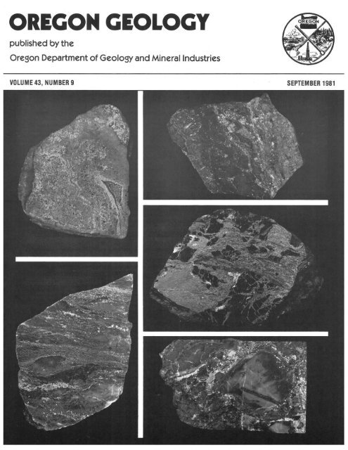
COVER PHOTO<br />
Polished slabs from massive sulfide deposits in southwestern<br />
<strong>Ore</strong>gon. Clockwise, from upper left: massive pyrite (light<br />
and medium gray) and sphalerite (dark gray) with colloform<br />
banding, Queen of Bronze Mine; coarse breccia composed of<br />
pyrite and chalcopyrite (concentrated in right half) and mafic<br />
rock fragments, Queen of Bronze Mine; sheared chalcopyritepyrrhotite<br />
lenses (light) and chloritic matrix (dark), Waldo<br />
Mine; mixed chert-volcanic-sulfide (pyrite and chalcopyrite)<br />
breccia, Turner-Albright Mine; layered sulfide (pyrite, chalcopyrite,<br />
and sphalerite) and barite with numerous barite lenses,<br />
Silver Peak Mine. All samples are approximately 10 em across.<br />
Photographed by Lowell Kohnitz, U.S. Geological Survey. See<br />
article beginning next page.<br />
DOGAM I releases new bibliography,<br />
map index, lineation study, and<br />
geologic maps<br />
The <strong>Ore</strong>gon <strong>Department</strong> of <strong>Geology</strong> and Mineral Industries<br />
(DOGAMI) announces the release of the following new<br />
publications:<br />
Bulletin 102-Bibliography 0/ the <strong>Geology</strong> and Mineral<br />
Resources 0/ <strong>Ore</strong>gon (Seventh Supplement, January 1, 1976,<br />
to December 31, 1979), compiled by Debbie Burnetti, Editor,<br />
GeoRef, and Klaus Neuendorf, Editor/Librarian, <strong>Ore</strong>gon<br />
<strong>Department</strong> of <strong>Geology</strong> and Mineral Industries. Produced in<br />
cooperation with GeoRef, the computerized information<br />
system of the American Geological Institute, this 68-page<br />
book presents bibliographic information from 1976 through<br />
1979 on the geology and mineral resources of <strong>Ore</strong>gon. Entries<br />
are indexed by author's name, subject, county. and rock unit.<br />
Bulletin 102. the seventh supplement to the <strong>Department</strong>'s<br />
original bibliography compiled in 1936 by R.C. Treasher and<br />
E.T. Hodge, sells for $4.00.<br />
Special Paper 13 - Faults and Lineaments 0/ the Southern<br />
Cascades, <strong>Ore</strong>gon, by C.F. Kienle, C.A. Nelson, and R.D.<br />
Lawrence, Foundation Sciences, Inc. This lineament and fault<br />
analysis of topographic maps and SLAR, Landsat, and U-2<br />
high-flight imagery was completed as the initial stage of the<br />
geothermal assessment of the southern Cascades funded by a<br />
grant from the U.S. <strong>Department</strong> of Energy to the <strong>Ore</strong>gon<br />
<strong>Department</strong> of <strong>Geology</strong> and Mineral Industries. The 23-page<br />
text describes procedures used to interpret data, criteria used<br />
to define lineaments, and geologic control of the expression of<br />
faults and lineaments and presents a tectonic interpretation of<br />
the study area. Included with the text are two two-color topographic<br />
maps (scale 1 :250,000) on which thermal and nonthermal<br />
springs, lineaments, and known faults are plotted.<br />
Cost of Special Paper 13 is $4.00.<br />
Geological Map Series GMS-14-Index to Published Geologic<br />
Mapping in <strong>Ore</strong>gon, 1898-1979, by C.A. Schumacher,<br />
Cartographer, <strong>Ore</strong>gon <strong>Department</strong> of <strong>Geology</strong> and Mineral<br />
Industries. GMS-14 shows areas in <strong>Ore</strong>gon that have been<br />
covered by geological, geophysical, ground-water, minerallocality,<br />
and other types of maps that have appeared in<br />
publications by DOGAMI, U.S. Geological Survey, Bureau of<br />
Mines, and others. The index, which replaces DOGAMI's<br />
Miscellaneous Paper 12 (Index to Published Geologic Mapping<br />
in <strong>Ore</strong>gon, 1898-1967), consists of six two-color maps<br />
(scale 1:1,000,000) on a U.S. Geological Survey quadrangleindex<br />
base, with county names and boundaries for easy<br />
reference. Each map has an extensive bibliography and is<br />
designed so that the reader may easily determine available<br />
maps, along with authors, titles, and dates, for any given area<br />
in <strong>Ore</strong>gon. GMS-14, the only available comprehensive index to<br />
(Continued, page 126)<br />
CONTENTS<br />
Massive sulfide deposits in oceanic-crust and island-arc<br />
terranes of southwestern <strong>Ore</strong>gon ................... 119<br />
Oil and gas developments. . . . . . . . . . . . . . . . . . . . . . . . . . .. 125<br />
State and county lease sales held during summer. . . . .. 125<br />
Diamond Shamrock completes drilling in Clatsop<br />
County ....................................... 125<br />
Eighth producer completed at Mist ................. 125<br />
Exploration continues in Willamette Valley. . . . . . . . .. 125<br />
Newberry well is hottest geothermal prospect yet reported<br />
in <strong>Ore</strong>gon. . . . . . . . . . . . . . . . . . . . . . . . . . . . . . . . . . . . . .. 126<br />
<strong>Ore</strong>gon fossils subject of new book ................... 126
Massive sulfide deposits in oceanic-crust and<br />
island-arc terranes of southwestern <strong>Ore</strong>gon<br />
by Randolph A. Koski, U.S. Geological Survey, 345 Middlefield Road, Menlo Park, California 94025, and<br />
Robert E. Derkey, <strong>Department</strong> of <strong>Geology</strong>, University of Idaho, Moscow, Idaho 83843<br />
INTRODUCTION<br />
Massive sulfide deposits containing significant amounts<br />
of base and precious metals occur in oceanic-crust and islandarc<br />
terranes of the northern Klamath Mountains in southwestern<br />
<strong>Ore</strong>gon. These terranes constitute parts of two major<br />
lithotectonic belts separated by an east-dipping thrust fault:<br />
the upper-plate western Paleozoic and Triassic belt and the<br />
lower-plate western Jurassic belt. Irwin (1960, 1966) first proposed<br />
and elaborated the concept of internally complex northsouth-trending<br />
arcuate lithic belts of regional extent juxtaposed<br />
in the Klamath Mountains. Subsequently, the geologic<br />
and tectonic settings of coherent terranes within these belts<br />
have been identified (for example, Irwin, 1972, 1977; Garcia,<br />
1979; Johnson, 1980); and plate-tectonic models for Klamath<br />
evolution through plate convergence, eastward-directed subduction,<br />
and accretion of oceanic rocks to the western continental<br />
margin of North America have been evolved (Hamilton,<br />
1969, 1978; Davis and others, 1978).<br />
In this report we discuss the massive sulfide deposits of<br />
southwestern <strong>Ore</strong>gon within this recently established platetectonic<br />
framework. These deposits (Figure 1) include the<br />
Queen of Bronze, the Cowboy, and others occurring in tectonic<br />
melange of the western Paleozoic and Triassic belt; the<br />
Turner-Albright in ophiolite of the western Jurassic belt; and<br />
the Silver Peak and Almeda in fragmental island-arc volcanic<br />
rocks of the western Jurassic belt. Together, these deposits<br />
have produced nearly one-third (approximately 4,000 tons) of<br />
<strong>Ore</strong>gon's total copper output, more than 70,000 troy ounces of<br />
silver and 2,000 troy ounces of gold, and minor amounts of<br />
lead and zinc. Although none of these deposits is currently being<br />
mined, all have been the focus of company activity during<br />
the last decade, and exploration activity continues at present.<br />
DEPOSITS IN OCEANIC-CRUST TERRANES<br />
Ophiolites are pseudostratigraphic assemblages of ultramafic<br />
and mafic rocks that appear to represent displaced and<br />
uplifted fragments of ancient oceanic crust and the upper mantle.<br />
Where complete, an ophiolite assemblage includes tectonized<br />
harzburgite and dunite, layered gabbro, sheeted<br />
diabase dike complexes, and pillow basalt. The basalt is commonly<br />
overlain by fine-grained marine sedimentary rocks,<br />
such as chert, shale, and limestone. Pillow lavas of ophiolite<br />
complexes in Cyprus, Turkey, Newfoundland, Italy, and<br />
many other localities are important hosts for "Cyprus-type"<br />
massive Fe-Cu sulfide deposits.<br />
The occurrence of ophiolite assemblages within the major<br />
tectonic belts of the northern Klamath Mountains was summarized<br />
by Irwin (1977). Two of the largest and best known<br />
exposures of ophiolite - the Preston Peak ophiolite in the<br />
western Paleozoic and Triassic belt and the Josephine ophiolite<br />
in the western Jurassic belt-are associated with massivesulfide<br />
mineralization.<br />
"<br />
EXPLANATION<br />
[II] Marine clastic sedimentary rocks (Cretaceous)<br />
~ Condrey Mountain Schist (Upper Jurassic)<br />
~<br />
Western Jurassic belt-- Marine clastic sedimentary,<br />
volcanic, and metavolcanic rocks (Jurassic)<br />
Granitic and gabbroic rocks (Jurassic or older)<br />
Ultramafic rocks (Jurassic or older)<br />
»0 , PROVINCE Western Paleozoic and Triassic belt-- Metasedimentary<br />
(")<br />
and metavolcanic rocks (Paleozoic and Triassic)<br />
"11<br />
COAST<br />
(")<br />
F."':l Amphibolite and schist (mainly Paleozoic and<br />
RANGE<br />
~ Triassic)<br />
A Thrust fault<br />
~ Upper plote<br />
Massive sulfide deposits<br />
I Queen of Bronze<br />
2 Cowboy<br />
3 Turner-Albright<br />
4 Silver Peak<br />
5 Almeda<br />
o<br />
I<br />
KILOMETERS<br />
Figure 1. Generalized geologic map of northern Klamath Mountains, showing location of major massive sulfide deposits.<br />
(<strong>Geology</strong> modified from Hotz, 1971)<br />
50<br />
I<br />
OREGON GEOLOGY, VOL. 43, NO.9, SEPTEMBER 1981 119
123"'35'<br />
EXPLANATION<br />
D Alluvium<br />
Ultramafic rocks<br />
Chert. argillite, and<br />
volcanic rocks<br />
Diabase and gabbro<br />
,- Fault ~o Strike and dip<br />
lao<br />
o Massive sulfide deposits<br />
1 Queen of Bronze<br />
1a North workings<br />
1b South workings<br />
2 Waldo<br />
3 Lilly<br />
4 Lyttle<br />
5 Mabel<br />
6 Cowboy<br />
o<br />
1<br />
I<br />
I<br />
KILOMETER<br />
Figure 2. Geologic map oj the Takifma area, <strong>Ore</strong>gon, showing locotion 0/ massive sulfide depo$its.<br />
Takilma-arta deposits<br />
Near Takilma, <strong>Ore</strong>gon, at the west edge of the western<br />
Paleozoic and Triassic belt, small masses of pyritic and pyrrhotitic<br />
massive sulfide are dispersed within tectonic melange<br />
composed of mafic and ultramafic rocks (Figure 2). The mafic<br />
rocks include diabase and diabase breccia, gabbro, diorite,<br />
and minor basalt showing varying degrees of greenschist-facies<br />
metamorphism. Exposures at the Queen of Bronze Mine and<br />
along the east fork of the Illinois Ri ver show that the diabasic<br />
and gabbroic rocks form dike or sill aggregates, although a<br />
well-developed sheeted-dike complex has not been identified.<br />
The mafic assemblage is in apparent fault contact with, and is<br />
overlain by, a sequence of thin-bedded gray radiolarian chert,<br />
argillite, graywacke, pebble conglomerate, rare limestone, and<br />
intercalated vesicular mafic lava nows.<br />
The mafic rocks and overlying strata are intruded and<br />
engulfed by large irregular masses of strongly serpentinized<br />
'20<br />
peridotite. Subrounded blocks of metadiabase, metagabbro,<br />
chert-argillite, and massive sulfide ranging in size from smaller<br />
than a meter to hundreds of meters across are incorporated<br />
into the ultramafic bodies. Contacts between the larger inclusions<br />
and serpentinite are typically sheared. The rock assemblage<br />
in the Takilma area is lithologically similar to that in the<br />
Preston Peak ophiolite 15 km to the south (Snoke, 1977). Field<br />
and geochemical evidence indicate to Snoke (1977) and Snoke<br />
and others (1977) that the ophiolitic ultramafic, mafic, and<br />
sedimentary rocks at Preston Peak represent the vestiges of an<br />
immature island-arc complex noored by oceanic lithosphere.<br />
More than 40,000 tons of ore averaging greater than 5<br />
weight percent Cu have been mined from at least six localities<br />
in the Takilma district (Shenon, 1933a). The sulfide mineralization<br />
is discontinuous and occurs within a 4-km-long northsouth-trending<br />
zone that follows the irregular contact between<br />
mafic and ultramafic rocks (Figure 2). Deposits in the diabasic<br />
wall rocks (Queen of Bronze, Waldo, Lilly, and Lyttle) consist<br />
OREGON GEOLOGY, VOL. 43, NO.9, SEPTEMBER 1911
of sharply defined pods, wedges, tabular lenses, and thin discontinuous<br />
seams of sulfide and quartz; these bodies generally<br />
have sharp contacts with unrnineralized diabase. Sulfide textures<br />
range from fine-grained massive-granular to coarsebrecciated;<br />
a few crudely layered and colloform features are<br />
also preserved. The mafic wall rocks show pervasive but varying<br />
degrees of recrystallization and alteration to the spilitic<br />
assemblage chlorite-actinolite-epidote-a1bite-calcite. Furthermore,<br />
the mafic rocks in contact with serpentinite are locally<br />
altered to pale-green rodingite composed of hydrogarnet, idocrase,<br />
chlorite, diopside, and prehnite.<br />
Mineralization in the ultramafic rocks (Cowboy and<br />
Mabel) consists of aggregates of closely spaced rounded<br />
massive sulfide "boulders" (Shenon, 1933a) in highly sheared<br />
serpentinite. Sulfide textures typically are coarse grained<br />
massive-granular, banded, or foliated. These textures appear<br />
to reflect metamorphic recrystallization and deformation by<br />
flowage. In addition to serpentine-group minerals (mostly<br />
antigorite), the ultramafic wall rock locally contains talc and<br />
magnesite.<br />
Principal sulfide minerals at the Queen of Bronze deposit<br />
(both the north and south workings) are, in decreasing abundance,<br />
pyrite, chalcopyrite, sphalerite, and pyrrhotite. At the<br />
Waldo deposit, pyrite, pyrrhotite, and chalcopyrite are all<br />
abundant; sphalerite and arsenopyrite are minor constituents.<br />
Pyrrhotite and chalcopyrite are the major phases in massive<br />
sulfide from the Lyttle, Mabel, and Cowboy deposits.<br />
Sphalerite and cubanite are abundant phases in some samples,<br />
and pyrite is very minor. Shenon (1933a) also reports the presence<br />
of cobaltite in "boulder" ore from the Cowboy Mine. The<br />
sulfide minerals are accompanied by varying amounts of interstitial<br />
quartz and less abundant chlorite, calcite, and serpentine<br />
minerals. Serpentinite at the Cowboy deposit hosts minute<br />
stringers and blebs of pyrrhotite and chalcopyrite.<br />
The deposits in the Takilma area appear to represent a<br />
discontinuous zone of sulfide mineralization within a complex<br />
of diabase and gabbro dikes and diabasic breccia, analogous<br />
to the mafic complex in the Preston Peak ophiolite described<br />
by Snoke (1977). Locally, the form and texture of primary<br />
sulfide mineralization indicate that open-space precipitation<br />
was an important process. Subsequent faulting and the movement<br />
and serpentinization of peridotite have resulted in disruption,<br />
brecciation, recrystallization, and deformation of the<br />
sulfide bodies in the serpentinite.<br />
Turner-Albright deposit<br />
Thirteen km southwest of Takilma, the Turner-Albright<br />
copper-gold deposit occurs in basaltic lavas and lava breccia of<br />
the Josephine ophiolite associated with the western Jurassic<br />
belt (Figure oi). Cunningham (1979) reports that the average<br />
grade of the deposit is 2.5 weight percent Cu, 0.5 weight percent<br />
Zn, and 0.025 troy ounces Au per ton. No prdduction of<br />
base metals has been reported from the Turner-Albright Mine,<br />
although the gossans have been treated for small amounts of<br />
gold. Recent regional geologic studies by Vail (1977) and<br />
Harper (1980) have led to a recognition of a complete ophiolite<br />
section that includes the Josephine Peridotite, a harzburgite<br />
tectonite, at its base. The peridotite is tectonically overlain by<br />
ultramafic and gabb~oic cumulate, massive gabbro, sheeted<br />
diabase dikes, mixed pillow lava and pillow-lava breccia, and a<br />
thin layer of metalliferous chert and mudstone. Thick flysch<br />
deposits containing interbedded graywacke, slate, and conglomerate<br />
conformably overlie the ophiolite section (Harper,<br />
1980). Figure 3 is a geologic section through the Josephine<br />
ophiolite. Field relations and petrographic and geochemical<br />
data indicate that the Josephine ophiolite formed in a marginal<br />
-. .. "<br />
.!I:<br />
::.<br />
e::'<br />
::.0-<br />
u:<br />
-<br />
Chert, argillite Red mudstone<br />
Pillow lava, pillow breccia<br />
Pillow-lava screens<br />
Diabase dikes<br />
Gabbro screens<br />
Rare plagiogranlte<br />
Massive gabbro<br />
Banded gabbro<br />
Wehrlite, dunite,<br />
pyroxenite gabbro<br />
Fault<br />
Gabbro dikes<br />
Harzburgite tectonite,<br />
dunite<br />
Podlform chromite<br />
Sulfide zone<br />
Epidote veins<br />
Figure 3. Geologic section of the Josephine ophiolite.<br />
(Modified from Harper, 1980)<br />
basin between the North American Plate margin and an offshore<br />
volcanic arc during Jurassic time (Dick, 1977; Vail,<br />
1977; Harper, 1980).<br />
Cunningham (1979) recently described the geology and<br />
geochemistry of the Turner-Albright deposit and the associated<br />
ophiolitic rocks. The mineralization occurs within the upper<br />
plate of an east-dipping thrust fault; the footwall of the<br />
thrust is barren peridotite (Figure 4a). The rocks hosting<br />
massive, vein, and disseminated sulfide consist of spilitized<br />
mafic lavas and volcanic breccia intruded by comagmatic<br />
diabase and gabbro. Pyritic lenses of bedded fossiliferous tuff<br />
and tuffaceous shale intercalated within the volcanic pile are<br />
supportive evidence for a submarine eruptive episode.<br />
As shown by cross section A-A' (Figure 4b), the steeply<br />
northeast-dipping layer of massive sulfide breccia, expressed<br />
by prominent linear gossan zones at the surface, grades northward<br />
into a columnar zone of mixed volcanic rocks, chert, and<br />
sulfide breccia. The sulfide assemblage is dominated by pyrite,<br />
although chalcopyrite and sphalerite are common and locally<br />
abundant. In the zone of massive sulfide breccia, subangular<br />
to subrounded pyritic sulfide fragments occur in a matrix of<br />
finer grained pyrite, quartz, altered lithic fragments, chalcopyrite,<br />
"nd sphalerite. Many individual sulfide fragments<br />
display thin alternating bands of pyrite and sphalerite. Pyrite-,<br />
chalcopyrite-, and sphalerite-bearing veinlets that crosscut<br />
massive pyrite and banded pyrite-sphalerite fragments provide<br />
evidence for multiple episodes of sulfide deposition.<br />
The mixed-breccia zone has the characteristics of a hydrothermal<br />
feeder system. The zone contains discontinuous<br />
sulfide veinlets and disseminations; many lithic fragments are<br />
OREGON GEOLOGY, VOL. 43, NO.9, SEPTEMBER 1981<br />
121
I'I, " "" ":<br />
, , , \ I, , ' "<br />
\ " , ,I I ,'", I<br />
", ,'< I \' ,"<br />
", " ' I I ' I , , I I<br />
',I \ I , ' I<br />
, I " I I •• ", I, I I,<br />
" I I I, I '" I , ", J\" , , I' , " ' . ' , , :<br />
" I , 'I "" ' ' , ,<br />
," "-<br />
, '.,<br />
" .' ,<br />
, , "<br />
'" I, ,I<br />
"" ' '<br />
. .'<br />
,<br />
".<br />
(a.)<br />
I<br />
U"'-'<br />
o i, __ j,,-_-,,<br />
30 '" ...,'"<br />
~ "IO"<br />
IITII Goo ...<br />
D -"....;.....<br />
m H,"'''''_' .""."..<br />
~ ,<br />
....""...., .. ..<br />
0' ..•..<br />
0 ""''''''''<br />
-,<br />
.."<br />
~ """".."<br />
-.~~<br />
-< -,;,<br />
(b.)<br />
Figure 4, Geologic map (a) and cross section A-A' (b) oj<br />
Ihe Turner-Albrighl Mine. (Modified jrom Cunningham,<br />
/979)<br />
··:·'):· ···<br />
OREGON<br />
..<br />
G<br />
123 0 45'<br />
42 0 45' + '" ...<br />
fip;':: :.: ... ::.<br />
",,:- : :y.G-cr; : •• :.:<br />
.... ....<br />
~<br />
AREA '. /: ' .. ' .. ' .<br />
OF •. / :: ........ ::< . ..<br />
. ..... ."<br />
MAP::-"".:.·.· .• :: 1"' ..••"0<br />
. :.' ..,:::.' :<br />
' ............. :<br />
'. '.' .:.:<br />
' ..... .<br />
.: .<br />
replaced by sulfides along their margins. Microcrystalline<br />
hematitic jasper forms veinlets and fills inlerstices between<br />
altered volcanic fragments. Adjacent volcanic wall rocks are<br />
strongly chloritized and silicified. The configuration of the<br />
feeder zone and tabular massive sulfide body suggests that the<br />
Turner-Albright deposit may be overturned to the southwest.<br />
DEPOSITS IN ISLAND-ARC TERRANES<br />
Felsic submarine lavas and pyroclastic rocks in calcalkaline<br />
island-arc sequences host the important class of<br />
Kuroko-type massive sulfide deposits. These volcanogenic<br />
polymetallic deposits generally consist of one or more stratiform<br />
massive sulfide layers and lenses intercalated with<br />
volcanic strata and an underlying discordanl stockwork mineralization<br />
of lower grade. The latter feature may represent the<br />
hydrot hermal feeder system for the layered sulfide accumulations.<br />
Kuroko-type deposits in the Miocene Green Tuff province<br />
in Japan and in other island-arc complexes are importanl<br />
sources of base and precious metals.<br />
Stratiform volcanogenic massive sulfide deposits occur in<br />
fragmenlal metavolcanic rocks of the Rogue and Galice Formations<br />
in the western Jurassic belt of southwestern <strong>Ore</strong>gon.<br />
The texture, composition, and major- and trace-element patterns<br />
of the metavolcanic and volcaniclastic metasedimentary<br />
rocks indicate that the Rogue and Galice Formations represent<br />
a Jurassic island-arc sequence (Garcia, 1979). Much of the<br />
sulfide occurs within felsic pyroclastic units along two<br />
northeast-trending zones: (I) a northern zone southwest of<br />
Canyonville, and (2) a southern zone that crosses the Rogue<br />
River near Galice. The Silver Peak and Almeda are the most<br />
important deposits in the northern and southern zones, respectively<br />
(Figures I and 5),<br />
[Z]<br />
D·· ..<br />
.. "<br />
. '.' -: .<br />
EXPLANATION<br />
Serpentinite (Upper Jurassic or<br />
Lower Cretaceous)<br />
Dothan Formation (Upper Jurassic<br />
and Lower Cretaceous)<br />
Granitic and gobbroic rocks (Upper<br />
Jurassic or Lower Cretaceous)<br />
Amphibolite (Upper Jurassic)<br />
Golice Formation (Upper Jurassic)<br />
Metavolcanic rocks of Rogue Formation<br />
(Middle and Upper Jurassic)<br />
10 KILOMETERS<br />
Fault<br />
~ Thrust fault<br />
Upper<br />
plate<br />
Figure 5. Regional geology surrounding Ihe Silver Peak and Almeda Mine areas, G ~ Gafice,<br />
A = Almeda Mine, (Modified jrom Wells and Walker. 1953)<br />
SP =Silver Peak Mine,<br />
122 OREGON GEOLOGY, VOL. 43, NO.9, SEPTEMBER 1981
Silver Peak deposit<br />
During the years 1926, 1928-31, and 1936-37, the Silver<br />
Peak Mine had a recorded production of 6,620· tons of ore<br />
from which 735,600 pounds of Cu, 21,980 troy ounces Ag, and<br />
490 troy ounces Au were recovered (Ramp, 1972). During the<br />
period 1976-79, more than 12,000 ft of diamond drilling at the<br />
Silver Peak Mine and along the South Fork of Middle Creek<br />
3 km southwest of Silver Butte penetrated several massive<br />
pyritic lenses, but copper-zinc mineralization comparable to<br />
that exposed in the Silver Peak Mine was not detected.<br />
Jurassic metavolcanic rocks hosting the Silver Peak<br />
deposit lie in the upper plate of the Coast Ranges thrust and<br />
structurally overlie sedimentary rocks of the Dothan Formation<br />
(Figure 5). Johnson and Page (1979) have subdivided the<br />
greenschist-facies volcanic rocks near Silver Peak (previously<br />
the Rogue Formation) into a predominantly southeast-dipping<br />
sequence of rhyodacitic to andesitic flows, tuff, tuff breccia,<br />
agglomerate, and pillow basalt. Lava and tuff higher in the<br />
section (to the east) are interbedded with thin-bedded gray<br />
shale. The sequence is disrupted by southeast-dipping thrust<br />
faults and narrow slivers of serpentinite.<br />
Figure 6 is a generalized geologic cross section of the<br />
Silver Peak deposit. The stratigraphically lowest unit exposed<br />
in the mine area, a vesicular andesite flow, is overlain by<br />
dacitic to rhyodacitic tuff and flows that grade upward into<br />
foliated tuff and tuff-breccia deposits. The uppermost unit in<br />
the sequence, exposed on nearby Silver Butte, consists of thinbedded<br />
to massive siliceous tuff and interbedded tuffaceous<br />
sandstone.<br />
All known mineralization in the Silver Peak area occurs<br />
within the foliated-tuff horizon (Figure 6), which is locally<br />
altered to aggregates of chlorite-talc-sericite or quartz-sericite.<br />
Flattened lapilli and pumice fragments also are present in the<br />
tuff. Graded tuff beds, fragments with altered margins, and<br />
load and flame structures within the mineralized zone all indicate<br />
subaqueous deposition.<br />
Lenticular bodies of massive sulfide and barite as thick as<br />
4 m parallel the plane of foliation over an exposed strike length<br />
of 90 m; layering within the massive sulfide also parallels the<br />
foliation. Lenses of foliated tuff as thick as 1 m occur in the<br />
massive sulfide. Additional sedimentary structures in the<br />
massive sulfide include load structures on the underlying tuff,<br />
graded bedding, and flame structures into the overlying tuff.<br />
Numerous disturbed structures disrupt bedding continuity.<br />
Pyrite, the predominant sulfide mineral in the massive<br />
sulfide, generally occurs as subrounded grains in a matrix of<br />
one or more of the following minerals: quartz, barite, chalcopyrite,<br />
sphalerite, bornite, and Zn-rich tennantite. The individual<br />
pyrite grains appear to be detrital fragments cemented<br />
by other sulfide and gangue minerals. Small blebs of chalcopyrite,<br />
bornite, tennantite, and sphalerite are present in the<br />
Bedded tuff and tuffaceous sand<br />
Dacite tuff and<br />
Andesite flow<br />
NW<br />
I 50 m !<br />
Figure 6. Generalized geologic cross section through the<br />
Silver Peak deposit.<br />
SE<br />
pyrite, particularly pyrite grains surrounded by copper and<br />
zinc minerals. Galena is a very minor constituent of the ores at<br />
Silver Peak, and no silver minerals have been found.<br />
Vertical zonation similar to that found in Kuroko-type<br />
deposits is evident in several underground exposures in which<br />
loosely bound massive pyrite (friable yellow ore) yields upward<br />
to dense massive pyrite-chalcopyrite (yellow ore), massive<br />
pyrite-sphalerite, tennantite-bornite-barite (black ore), and<br />
massive barite. Barite lenses are present in the black ore zone.<br />
Although massive ferruginous chert typical of Kuroko-type<br />
deposits is absent at Silver Peak, hematitic chert fragments as<br />
large as 3 cm in diameter are present in flow-banded tuff overlying<br />
the massive sulfide and massive barite. This flow-banded<br />
tuff unit also contains as much as 10 percent disseminated<br />
lapilli-size pyrite and chalcopyrite grains. The massive ore is<br />
locally underlain by 1-2 m of silicified tuff containing vein lets<br />
of pyrite, as well as disseminated pyrite, chalcopyrite, and<br />
bornite. However, no deep feeder system underlying the<br />
massive sulfide has been identified.<br />
Almeda deposit<br />
The Almeda Mine is situated on the north bank of the<br />
Rogue River, approximately 30 km southwest of the Silver<br />
Peak Mine. Shenon (1933b) reports that, between 1911 and<br />
1916, 16,619 tons of ore produced from the Almeda deposit<br />
yielded 259,800 pounds of Cu, 7,197 pounds Pb, 1,540 troy<br />
ounces Au, and 48,387 troy ounces Ag.<br />
Sulfide mineralization occurs in highly altered fragmental<br />
rhyolitic to dacitic metavolcanic rocks assigned to the Rogue<br />
Formation, immediately below the depositional contact with<br />
overlying slate and graywacke of the Galice Formation. Silllike<br />
masses of dacite porphyry are emplaced along the Rogue<br />
Galice boundary. The volcanic and sedimentary sequence<br />
occurs east of, and is in fault contact with, an ophiolite assemblage<br />
of amphibolite, metagabbro, and ultramafic rocks. Garcia<br />
(1979) suggests that this mafic-ultramafic complex<br />
represents the oceanic crust upon which the island arc that<br />
parented the Rogue and Galice Formations was constructed.<br />
At the Almeda Mine, a 60-m-thick steeply east-dipping<br />
mass of intensely silicified fragmental rock known as the "Big<br />
Yank lode" occurs between clastic sedimentary rocks of the<br />
Galice Formation and coarse rhyolitic agglomerate. The mass<br />
contains lenses and fragments of massive sulfide and barite in<br />
a silicified volcanic matrix. Lenses of massive sulfide have a<br />
fragmental texture and contain clasts of sulfide, barite, and<br />
altered volcanic rock. Locally, alternating layers of sulfide and<br />
barite appear to be bedded deposits. The most abundant hypogene<br />
sulfide is pyrite, although chalcopyrite, sphalerite, and<br />
galena are locally concentrated in massive accumulations.<br />
Diller (1914, p. 75) refers to the stratiform mineralization here<br />
as "copper ore with barite."<br />
Disseminated and vein sulfide, mostly pyrite, is present in<br />
silicified rock between the sulfide and barite lenses and lithic<br />
fragments and also forms an extensive stockwork in silicified<br />
volcanic breccia stratigraphically below the Big Yank lode.<br />
This low-grade stockwork zone reportedly contains anomalous<br />
gold and silver values (Shenon, 1933b) and is referred to as<br />
"siliceous gold-silver ore" by Diller (1914, p. 75). Quartzsericite<br />
alteration and pyritization decrease in intensity below<br />
the Almeda deposit but extend southward from the Rogue<br />
River along the contact between the Rogue and Galice Formations.<br />
Sill-like masses of dacite porphyry emplaced near the<br />
contact are locally altered to fine-grained quartz and sericite<br />
accompanied by disseminated pyrite. With depth below the<br />
stratiform sulfide, quartz-sericite alteration diminishes, and<br />
the felsic volcanic rocks contain chlorite and epidote.<br />
OREGON GEOLOGY, VOL. 43, NO.9, SEPTEMBER 1981<br />
123
Table 1. Characteristics oj principal massive suljide deposits in southwestern <strong>Ore</strong>gon<br />
Deposit Host rocks Metals<br />
Takilma area<br />
Queen of Bronze Diabase, gabbro Cu (Zn, Co, Au)<br />
Cowboy Serpentinite Cu (Co, Ni, Au, Zn)<br />
Turner-Albright Basalt, volcanic Cu (Au, Zn, Co)<br />
breccia<br />
Almeda Rhyolite to dacite Cu (Au, Ag, Zn, Pb)<br />
breccia<br />
Silver Peak Dacite to rhyodacite Cu (Au, Zn)<br />
tuff<br />
Mineralization Stockwork Classification<br />
Pyrite, chalcopyrite, No Cyprus type(?)<br />
sphalerite, quartz, chlorite<br />
Pyrrhotite, chalcopyrite, No Cyprus type(?)<br />
sphalerite, cubanite,<br />
cobaltite(?), quartz,<br />
antigorite, chlorite<br />
Pyrite, chalcopyrite, Yes Cyprus type<br />
sphalerite, quartz<br />
Pyrite, chalcopyrite, Yes Kuroko type<br />
sphalerite, galena,<br />
tetrahedrite, barite, quartz<br />
Pyrite, chalcopyrite,<br />
sphalerite, tennantite,<br />
? Kuroko type<br />
.<br />
bornite, barite, quartz<br />
CONCLUSIONS<br />
Table 1 lists major characteristics of the Queen of Bronze,<br />
Cowboy, Turner-Albright, Silver Peak, and Almeda sulfide<br />
deposits. These deposits in southwestern <strong>Ore</strong>gon are believed<br />
to have been formed by submarine volcanogenic processes<br />
operating in distinct tectonic environments. The copper<br />
deposits near Takilma, <strong>Ore</strong>gon, are components of a tectonic<br />
melange and lack clearly defined stockwork zones; their<br />
spatial relation to volcanic centers is uncertain. However, the<br />
Fe-rich Fe-Cu-Zn sulfide assemblage, preservation of layered<br />
or fragmental massive-sulfide textures, and an ophiolitic wall<br />
rock environment all suggest an analogy with Cyprus-type<br />
cupreous-pyrite deposits. The sulfide-bearing ophiolitic rocks<br />
may have formed within a near-arc basin or at a subvolcanic<br />
level within a primitive island-arc environment. The zone of<br />
sulfide mineralization has been disrupted by later faulting and<br />
diapiric emplacement of serpentinite.<br />
The geologic setting, stratigraphy, and composition of the<br />
Turner-Albright deposit strongly resemble those of Cyprustype<br />
deposits. The stratiform zone of pyritic massive sulfide<br />
breccia and the associated stockwork veining and quartzchlorite<br />
alteration occur in mafic volcanic rocks that stratigraphically<br />
overlie an extensive sheeted-dike complex in the<br />
Josephine ophiolite. Volcanism and sulfide deposition were<br />
contemporaneous at a site of sea-floor spreading in a Mesozoic<br />
marginal-basin environment.<br />
The polymetallic Silver Peak and Almeda deposits, which<br />
have numerous Kuroko-type characteristics, occur in fragmental<br />
calc-alkaline volcanic rocks at separate stratigraphic intervals<br />
within the island-arc assemblage that include the Rogue<br />
and Galice Formations. Extensive quartz-sericite-pyrite mineralization<br />
in subjacent pyroclastic rocks at the Almeda Mine<br />
may represent a hydrothermal feeder system in the Rogue section.<br />
Massive sulfide and barite deposition are proximal with<br />
respect to the central vent. At Silver Peak, a thin but laterally<br />
extensive horizon of sulfide-bearing sericitic tuff underlies<br />
zoned massive sulfide and barite, but no deep stockwork zone<br />
has been located. Disrupted sulfide layers, fragments of<br />
massive barite in black ore, detrital sulfide, load structures,<br />
and graded bedding all indicate that the sulfides may have<br />
been transported downslope from a central vent by slumping<br />
and debris flow.<br />
Albers (1981) discusses the syngenetic relation between<br />
certain mineral-deposit-. types and accreted "tectono-stratigraphic"<br />
belts. Deposits like those described in this report may<br />
occur elsewhere in the northern Klamath Mountains and offer<br />
a potential source for copper, gold, silver, zinc, cobalt, nickel,<br />
and barite. The recognition and interpretation of oceaiiic-crust<br />
and island-arc terranes in the Klamath province are key factors<br />
in exploring for base- and precious-metal deposits in southwestern<br />
<strong>Ore</strong>gon.<br />
ACKNOWLEDGEMENTS<br />
The authors thank John P. Albers and Dennis P. Cox for<br />
critical reviews of the manuscript.<br />
REFERENCES CITED<br />
Albers, J.P., 1981, Tectonic framework and metallogeny in California,<br />
in Circum-Pacific Energy and Mineral Resources Conference<br />
II, American Association of Petroleum Geologists Memoir (in<br />
press).<br />
Cunningham, C.T., 1979, <strong>Geology</strong> and geochemistry of a massive<br />
sulfide deposit and associated volcanic rocks, Blue Creek District,<br />
southwestern <strong>Ore</strong>gon: Corvallis, <strong>Ore</strong>g., <strong>Ore</strong>gon State University<br />
master's thesis, 165 p.<br />
Davis, G.A., Monger, J.W.H., and Burchfield, B.C., 1978, Mesozoic<br />
construction of the Cordilleran "collage," central British Columbia<br />
to central California, in Howell, D.G., and McDougall, K.A., eds.,<br />
Mesozoic paleogeography of the western United States: Pacific<br />
Coast Paleogeography Symposium 2, Pacific Section, Society of<br />
Economic Paleontologists and Mineralogists, Sacramento, Calif.,<br />
1978, p. 1-32.<br />
Dick, H.J.B., 1977, Partial melting in the Josephine Peridotite. I. The<br />
effect on mineral composition and its consequence for geobarometry<br />
and geothermometry: American Journal of Science, v. 277, no.<br />
7, p. 801-832.<br />
Diller, J.S., 1914, Mineral resources of southwestern <strong>Ore</strong>gon: U.S.<br />
Geological Survey Bulletin 546, 147 p.<br />
Garcia, M.O., 1979, Petrology of the Rogue and Galice Formations,<br />
Klamath Mountains, <strong>Ore</strong>gon: Identification of a Jurassic island-arc<br />
sequence: Journal of <strong>Geology</strong>, v. 87, no. I, p. 29-41.<br />
Hamilton, W., 1969, Mesozoic California and the underflow of<br />
Pacific mantle: Geologic Society of America Bulletin, v. 80, no. 12,<br />
p. 2409-2429.<br />
- - - 1978, Mesozoic tectonics of the western United States, in<br />
124<br />
OREGON GEOLOGY, VOL. 43, NO.9, SEPTEMBER 1981
Howell, D.G., and McDougall, K.A., eds., Mesozoic paleogeography<br />
of the western United States: Pacific Coast Paleogeography<br />
Symposium 2, Pacific Section, Society of Economic Paleontologists<br />
and Mineralogists, Sacramento, Calif., 1978, p. 33-70.<br />
Harper, G.D., 1980, The Josephine ophiolite-remains of a Late<br />
Jurassic marginal basin in northwestern California: <strong>Geology</strong>, v. 8,<br />
no. 7, p. 333-337.<br />
Hotz, P.E., 1971, <strong>Geology</strong> of lode gold districts in the Klamath<br />
Mountains, California and <strong>Ore</strong>gon: U.S. Geological Survey<br />
Bulletin 1290, 91 p.<br />
Irwin, W.P., 1960, Geologic reconnaissance of the northern Coast<br />
Ranges and Klamath Mountains, California, with a summary of the<br />
mineral resources: California Division of Mines Bulletin 179, 80 p.<br />
- - - 1966, <strong>Geology</strong> of the Klamath Mountains province, in Bailey,<br />
E.H., ed., <strong>Geology</strong> of northern California: California Division of<br />
Mines and <strong>Geology</strong> Bulletin 190, p. 19-38.<br />
- - - 1972, Terranes of the western Paleozoic and Triassic belt in the<br />
southern Klamath Mountains, California, in Geological Survey<br />
research 1972, chapter C: U.S. Geological Survey Professional<br />
Paper 800-C, p. C103-Clll.<br />
- - - 1977, Ophiolitic terranes of California, <strong>Ore</strong>gon, and Nevada,<br />
in Coleman, R.G., and Irwin, W.P., eds., North American ophiolites:<br />
<strong>Ore</strong>gon <strong>Department</strong> of <strong>Geology</strong> and Mineral Industries<br />
Bulletin 95, p. 75-92.<br />
Johnson, M.G., 1980, Geochemical variations within an ancient<br />
island arc, southwestern <strong>Ore</strong>gon (abs.): Geological Society of<br />
America Abstracts with Programs, v. 12, no. 3, p. 113.<br />
Johnson, M.G., and Page, N.J., 1979, Preliminary geologic map of<br />
the metavolcanic and associated rocks in parts of the Canyonville,<br />
Days Creek, and Glendale quadrangles, <strong>Ore</strong>gon: U.S. Geological<br />
Survey Open-File Report 79-283, scale 1 :62,500.<br />
Ramp, L., 1972, <strong>Geology</strong> and mineral resources of Douglas County,<br />
<strong>Ore</strong>gon: <strong>Ore</strong>gon <strong>Department</strong> of <strong>Geology</strong> and Mineral Industries<br />
Bulletin 75, 106 p.<br />
Shenon, P.J., 1933a, Copper deposits in the Squaw Creek and Silver<br />
Peak districts and at the Almeda Mine, southwestern <strong>Ore</strong>gon, with<br />
notes on the Pennell and Farmer and Banfield prospects: U.S.<br />
Geological Survey Circular 2, 35 p.<br />
- - - 1933b, <strong>Geology</strong> and ore deposits of the Takilma-Waldo district,<br />
<strong>Ore</strong>gon, including the Blue Creek district: U.S. Geological<br />
Survey Bulletin 846-B, p. 141-194.<br />
Snoke, A.W., 1977, A thrust plate of ophiolitic rocks in the Preston<br />
Peak area, Klamath Mountains, California: Geological Society of<br />
America Bul1etin, v. 88, no. 11, p. 1641-1659.<br />
Snoke, A.W., Bowman, H.R., and Hebert, A.J., 1977, The Preston<br />
Peak ophiolite, Klamath Mountains, California, an immature<br />
island arc: petrochemical evidence, in Short contributions to<br />
California geology: California Division of Mines and <strong>Geology</strong><br />
Special Report 129, p. 67-79.<br />
Vail, S.G., 1977, <strong>Geology</strong> and geochemistry of the <strong>Ore</strong>gon Mountain<br />
area, southwestern <strong>Ore</strong>gon and northern California: Corvallis,<br />
<strong>Ore</strong>g., <strong>Ore</strong>gon State University doctoral dissertation, 159 p.<br />
Wells, F.G., and Walker, G.W., 1953, Geologic map of the Galice<br />
quadrangle, <strong>Ore</strong>gon: U.S. Geological Survey Geologic Quadrangle<br />
Map GQ-25, scale 1:62,500. 0<br />
Oil and gas developments<br />
State and county lease sales<br />
held during summer<br />
An <strong>Ore</strong>gon State Lands Division lease sale held July 8 and<br />
9, 1981, offered over 107,000 acres in several counties and<br />
brought bonus bids totaling $1.6 million. The auction, which<br />
took place in Salem, offered property in the counties of Clatsop,<br />
Columbia, Coos, Crook, Deschutes, Douglas, Harney,<br />
and Malheur. High total bonus bids were made by Gulf Oil<br />
Corporation, Phillip Brock, A.G. Andrikopoulos, Marathon<br />
Oil Company, and Nahama and Weagant Energy Company.<br />
The high bid of $230 per acre bonus was made by Nahama and<br />
Weagant for a parcel of 640 acres in sec. 13, T. 7 N., R. 6 W.<br />
Terms of State leases are as follows: lO-year duration,<br />
$1.00 per acre per year, and one-eighth (Va) royalty. A drilling<br />
commitment within seven (7) years is also a stipulation of the<br />
leases.<br />
An auction of mineral rights of Columbia County lands<br />
was held August 13, 1981, at the County Courthouse in St.<br />
Helens near Mist. Of a total of 65,330 acres offered, 50,025<br />
acres were sold for a total of $1,528,504.00 cash bonus bids.<br />
Bids ranged from $0.25 to $93.00 per acre. Nahama and<br />
Weagant of Bakersfield, Calif., were successful bidders for the<br />
highest priced parcel, 600 acres at $93.00 per acre.<br />
Diamond Shamrock completes drilling<br />
in Clatsop County<br />
Diamond Shamrock Corporation has completed a threewell<br />
program in Clatsop County. The wells, drilled to depths<br />
of 7,864, 5,700, and 6,095 ft, are located near Knappa,<br />
Necanicum, and Saddle Mountain. All were abandoned as dry<br />
holes before reaching their projected depths. No further drilling<br />
plans for Clatsop County have been announced by Diamond<br />
Shamrock. The company, however, continues to remain<br />
active in the Mist field as partners with Reichhold Energy Corporation<br />
and Northwest Natural Gas Company.<br />
Eighth producer completed at Mist<br />
Reichhold Energy Corporation, in partnership with Diamond<br />
Shamrock Corporation and <strong>Ore</strong>gon Natural Gas Development,<br />
has completed its eighth producing gas well in the<br />
Mist Gas Field. Located in sec. I, T. 6 N., R. 5 W., approximately<br />
2 mi north of the town of Mist, Columbia County 13-1<br />
was completed August 17, 1981, flowing 2.6 million cubic feet<br />
of gas per day.<br />
Plans are to connect this well to the Northwest Natural<br />
Gas pipeline that carries gas from the Mist field to Clatskanie.<br />
An offset well will also be drilled.<br />
Exploration continues in Willamette Valley<br />
American Quasar Petroleum Company's Kenneth Wetgen<br />
26-32, NE ~ sec. 26, T. 13 S., R. 4 W., Linn County, was<br />
spudded August 14, 1981. Proposed depth is 5,000 ft; the contractor<br />
is Paul Graham Drilling Company.<br />
Quintana Petroleum Corporation's Gath I, SE ~ sec. 16,<br />
T. 8 S., R. 2 W., Marion County, was also spudded August 14,<br />
1981. Proposed depth is 6,000 ft; the contractor is John Taylor<br />
Drilling Company. 0<br />
OREGON GEOLOGY, VOL. 43, NO.9, SEPTEMBER 1981<br />
125
Newberry well is hottest geothermal prospect yet reported in <strong>Ore</strong>gon<br />
The hottest temperatures measured so far in a geothermal<br />
energy prospect in <strong>Ore</strong>gon were reported July 23, 1981, by the<br />
U.S. Geological Survey (USGS), <strong>Department</strong> of the Interior.<br />
USGS scientists said that a geothermal test hole being<br />
drilled in the summit crater of Newberry Volcano, about 25 mi<br />
southeast of Bend, <strong>Ore</strong>g., produced temperatures of 190°C<br />
(375°F) at a depth of 2,656 ft. A temperature of at least 150°C<br />
(300°F) is generally considered the minimum necessary for<br />
commercial consideration in using a geothermal resource to<br />
produce electricity.<br />
Robert Tilling, chief, USGS Office of Geophysics and<br />
Geochemistry, emphasized that "the Newberry report is not<br />
yet a proven commercial discovery, but it is ·the most encouraging<br />
geothermal find in <strong>Ore</strong>gon and could spur a reevaluation<br />
of the nearby Cascade geothermal-energy potential.<br />
Finding a prospect as hot as the Newberry well provides at<br />
least the first step necessary to prove the feasibility of a<br />
geothermal resource-high temperatures. The next step would<br />
be to determine if there is enough flow to produce the volume<br />
and rate of the hot geothermal fluids that could be used in a<br />
power generation plant for conversion of the geothermal<br />
energy to electricity."<br />
Edward Sammel, USGS hydrologist who is supervising<br />
the geothermal drilling at Newberry, said that plans are to drill<br />
the 3-in. hole to as deep as 3,000 ft and then run tests at that<br />
depth to determine temperature and rate of flow. The well is<br />
part of the USGS geothermal-research program that, in addition<br />
to other related efforts, is conducting a comprehensive<br />
regional evaluation of the geothermal potential of the Cascade<br />
Range in Washington, <strong>Ore</strong>gon, and California.<br />
The Newberry crater is in the Deschutes National Forest<br />
and is part of the "Newberry Caldera Known Geothermal<br />
Resource Area" (KGRA) previously outlined by the USGS.<br />
The U.S. Forest Service has been conducting an environmental<br />
impact study should any part of this KGRA ever be offered by<br />
the federal government for leasing for geothermal exploration.<br />
Newberry Volcano is one of the largest volcanoes that<br />
formed in the conterminous 48 states during the geologically<br />
recent period of the last 2 million years (Quaternary Period).<br />
The last known eruption from the present Newberry Crater occurred<br />
about 1,400 years ago, and there is a high probability<br />
that extremely hot rock, perhaps even molten rock (magma),<br />
may still underlie the crater at fairly shallow depths.<br />
The summit of Newberry Volcano has collapsed to form a<br />
caldera or crater about 5 mi in diameter. The collapse followed<br />
the eruption of vast volumes of volcanic ash and lava from the<br />
volcano's underlying magma chamber. Newberry Crater is<br />
similar in its origin to the crater formed by the violent eruption<br />
and associated collapse of nearby Mount Mazama about 6,700<br />
years ago, whose caldera now contains scenic Crater Lake.<br />
Newberry Crater contains two small lakes, Paulina and East<br />
lakes.<br />
Temperature measurements in the test hole were made by<br />
David Blackwell, <strong>Department</strong> of Geological Sciences, Southern<br />
Methodist University. USGS scientists said that in the<br />
lower 450 ft of the test hole, the temperature gradient became<br />
extremely high-about 600°C per kilometer, compared to a<br />
worldwide continental average of about 30°C per kilometer.<br />
"This high gradient is extremely encouraging for two<br />
reasons," Tilling said. "First, it suggests an increased potential<br />
for development, should the high gradient continue at deeper<br />
depths. Second, and perhaps more important, the high gradient<br />
tends to confirm -a theory that the low temperatures at<br />
shallow depths that h.ave discouraged previous geothermal ex-<br />
ploration in the nearby Cascade Range may reflect more the<br />
effects of shallow lateral flow of cool ground water rather than<br />
the real geothermal-energy potential. We think the high<br />
precipitation and generally high rate of ground-water recharge<br />
in the Pacific Northwest have combined to dilute and cool its<br />
geothermally heated water and to lower its rock temperatures<br />
at shallow depths during the past thousand years or so. As a<br />
result, temperature data from shallow drill holes in the past<br />
have tended to discourage additional geothermal development<br />
in the region. If temperatures remain high in the Newberry<br />
well, it could spur a re-evaluation of the geothermal energy<br />
potential in the Cascades."<br />
Similar encouraging results were recently reported in the<br />
Canadian Cascades where a geothermal exploration project<br />
measured a temperature of more than 200°C in the Meagher<br />
Creek area of British Columbia. The recent 'eruptions of<br />
Mount St. Helens remain the most obvious manifestations of<br />
the internal heat and geothermal activity in the Cascade<br />
Range. 0<br />
<strong>Ore</strong>gon fossils subject of new ~book<br />
William N. Orr, professor of paleontology and geology at<br />
the University of <strong>Ore</strong>gon, and Elizabeth L. Orr, catalog<br />
librarian, are the authors of a new 284-page paperback book,<br />
Handbook of <strong>Ore</strong>gon Plant and Animal Fossils.<br />
The book, which covers all aspects of <strong>Ore</strong>gon plant and<br />
animal fossils, is divided into chapters on fossil plants, pollen,<br />
invertebrates, trace fossils, arthropods, freshwater fish, birds,<br />
marine vertebrates, and mammals and other land vertebrates.<br />
It contains drawings of fossils, lists of animal ranges, fossillocality<br />
lists and maps, correlation charts, a 4OO-entry bibliography,<br />
and an index. The text reviews the literature on<br />
various fossils and discusses such paleontological subjects as<br />
ancient environments and settings, the forms in which fossils<br />
were preserved, and the ways fossils are used by geologists.<br />
The book is written for the knowledgeable layman but is also a<br />
useful reference for the professional geologist.<br />
Price of Handbook of <strong>Ore</strong>gon Plant and Animal Fossils is<br />
$10.95. It is available by mail from William N. or Elizabeth<br />
Orr, P.O. Box 5286, Eugene, OR 97405. 0<br />
(New DOGAMI publications, from page 118)<br />
geologic mapping in <strong>Ore</strong>gon, costs $7.00.<br />
Open-File Reports 0-81-5, Preliminary Geologic Map of<br />
the Amity and Mission Bottom Quadrangles, <strong>Ore</strong>gon, and<br />
0-81-6, Preliminary Geologic Map of the McMinnville and<br />
Dayton Quadrangles, <strong>Ore</strong>gon, begun in 1979 by H.G.<br />
Schlicker and completed in 1980 and 1981 by M.E. Brownfield,<br />
<strong>Ore</strong>gon <strong>Department</strong> of <strong>Geology</strong> and Mineral Industries.<br />
These blackline preliminary geologic maps (scale 1 :24,000)<br />
cover areas north and northwest of Salem in the northern<br />
Willamette Valley and represent DOGAMI's ongoing program<br />
to map strategic quadrangles in western <strong>Ore</strong>gon that are, as in<br />
this case, experiencing rapid population growth. The maps<br />
delineate the geologic units and structure of the area and identify<br />
fossil and microfossil localities and abandoned oil and gas<br />
exploratory wells. Cost of each of these open-file reports is<br />
$4.00.<br />
All of these new releases are available for inspection or<br />
purchase at the <strong>Ore</strong>gon <strong>Department</strong> of <strong>Geology</strong> and Mineral<br />
Industries, 1005 State Office Building, Portland, OR 97201.<br />
Payment must accompany orders of less than $20.00 0<br />
126<br />
OREGON GEOLOGY, VOL. 43, NO.9, SEPTEMBER 1981
Available publications<br />
I<br />
w<br />
z<br />
....<br />
Q<br />
w<br />
r<br />
Q<br />
'"<br />
Z<br />
o<br />
....<br />
:::><br />
<br />
I<br />
::E<br />
II:<br />
f!<br />
II:<br />
~<br />
II:<br />
o<br />
¢<br />
BULLETINS Pm No. Copies AIDCHIDt<br />
33. Bibliography (1st supplement) geolOIY and mineral resources of <strong>Ore</strong>gon, 1947: Allen .........•............ S 1.00<br />
36. Paptrs on Tertiary foraminifera: Cushman, Siewan, and Stewan, 1949: Y. 2 . . ... . .. . . . .. . .. •• ... . ... . .. . \.25<br />
44. Bibliovaphy (2nd supplement) loolOlY and mineral resources orOrqon, 1953: Steere 2.00<br />
46. Ferruginous bauxite deposits, Salem Hills, 19S6: Corcoran and Libbey .. . ... . . .. . . ... . ... . ... . ... . .. . . .. 1.25<br />
49. Lode mines, Granite mining district. Granl County, <strong>Ore</strong>gon, 19j9: Koch . . ... . . .. . . ... . .. . ... . . .. . . .. . .. 1.00<br />
Sl. Bibliography (lrd supplemenl) ,eolOSY and mineral resources of <strong>Ore</strong>gon, 1962: Steere and Owen .. . ... . .. . . . 3.00<br />
H . LunarGeolop.ical Field Conference guidebook. 1965: Peterson and Gron. editors ... . ... . ... . ... . .... ... . . 3.50<br />
62. Andesite ConferenceJuidebook, 1968: Dole ... .... ............ ............ .... ............. ........ 3.50<br />
65. Procccdinp of the Andesite Conference, 1969: (copies) . . .. . . ... . ... . .. . .... . ... . . .. . . .. . . ... . ... . .... 10.00<br />
67. Bibliography (4th supplement) geology and mineral resources of <strong>Ore</strong>gon, 1970: Roberts. . . . . " .... . 3.00<br />
7 1. GeolOgy of selected la va tubes in Bend area, <strong>Ore</strong>gon, 1971: G reeley .. . . ...... " .. ... . .. . 2.50<br />
77. Geologic field trips in northern <strong>Ore</strong>gon and southern Washington, 1973 . .. . ... . . .. . . ... . . .. . . .. . . ... . .. . 5.00<br />
78. Bibliography (5th supplement) geology and mineral resources of<strong>Ore</strong>80n, 1973: Roberts .. . . .. . . .. . • ... . . . . 3.00<br />
81. Environmental ,colo,y of Lincoln County, 1973: Schlicker and others . . .. . . .. . . .. . . . .. . . ... . .. .• .. . 9.00<br />
82. GeoloSic huards of Bull Run Watershed, Multnomah, Clackamas Counties, 1974: Beaulieu .............. . 6.50<br />
83. Eocene stratigraphy of southwestern <strong>Ore</strong>gon, 1974: Baldwin . . ................................•.. . 4.00<br />
84. Environmental ,colOiY of western Linn County, 1974: Beaulieu and others. . . . . 9.00<br />
85. Environmental geology of coastal Lane County, 1974: Schlicker and others . 9.00<br />
87. Environmental geology of western Coos and Douglas Counties, 1975 . . . . . . . . . .. . . .. . . .. . . .. . . .. . 9.00<br />
88. <strong>Geology</strong> and mineral resources of upper Chetco River drainage, 1975: Ramp . .. . . .. . . .. . . . . . . . .. . . .. . . .. . 4.00<br />
89. <strong>Geology</strong> and mineral resources of Deschutes County, 1976: Peterson and others. . . . . . .. . . 6.50<br />
90. Land uSC gcology of western Curry County, 1976: Beaulieu.. . . . . .. . . .. . . .. . . .. . . .. . 9.00<br />
91. Geologic huards of parts of northern Hood River, Wasco, and Sherman Counties, <strong>Ore</strong>gon, 1977: Beaulieu .. 8.00<br />
92. Fossils in <strong>Ore</strong>ion (reprinted from The O~ <strong>Bin</strong>), 1977. .. . . .. . . .. . ... . . .. . ... . . .. . . .. . . . . .. . ... 4.00<br />
93. <strong>Geology</strong>, mineral resources, and rock material of Curry County, <strong>Ore</strong>gon, 1977 . . . . ... . ... 7.00<br />
94. Land uSC geology of central Jackson County, <strong>Ore</strong>gon, 1977: Beaulieu . . . . . . . . .. . . .. . . .. . . ... . .. . 9.00<br />
95. North American ophiolites, 1977 ....................................................... . . ......... 7.00<br />
96. Magma lencsis: AGU Chapman Conference on Partial Melting, 1m ... . .. . . . ... •. .. . 12.50<br />
97. Bibliography (6th supplement) geolOIY and mineral resources of Orcgon, 1971 ·75. 1978 ............ •...... 3.00<br />
98. Geologic huards of eastern Benton County, <strong>Ore</strong>gon, 1979: Bela . ... . ... . .. . . .. . ... . . .. . . . .. •. ... . . 9.00<br />
99. GeoIOJic huards of northwestern Clackamas County, <strong>Ore</strong>gon, 1979: Schlicker and Finlayson . ... . 10.00<br />
100. <strong>Geology</strong> and mineral resources of Josephine County, Orcgon, 1979: Rampand Peterson ............,.. . .. . 9.00<br />
101 . GeoIOJic field trips in western Orcgon and southwestern Washington, 1980 ....................... , .. . ... 9.00<br />
102. Bibliogrtphy (7th supplement) 8co1ogy and mineral resources ofOrcgon, 1976-1979, 1981 ...... 4.00<br />
SPECIAL PAPERS<br />
I . Mission, goals, and purposes ofOrcgon <strong>Department</strong> or <strong>Geology</strong> and Mineral Industries, 1978 ............. .<br />
2. Field geoJOiY ofSW Broken Top quadrangle. <strong>Ore</strong>gon, 1978: Taylor . . ... . ... . ... . .................... . .<br />
3. Rock material resources of Clackamas, Columbia, Multnomah, and Washington Counties, <strong>Ore</strong>gon, 1978:<br />
G ray and others. . .. . ... . ... . .. . . .. . .... . ........................ .<br />
4. Heat now of<strong>Ore</strong>80n, 1978: Blackwell, Hull, Bowen, and Steele . . . . ................................ .<br />
5. Analysis I nd forecasts of the demand for rock materials in <strong>Ore</strong>gon, 1979: Friedman and others ..... . ..... . .<br />
6. GeoIOiY of the La Grinde area, <strong>Ore</strong>gon, 1980: Barrash and others ...... .<br />
7. Pluvial Fort Rock Lake, Lake County, <strong>Ore</strong>gon. 1979: Allison . . . . .. .. . ........................ .<br />
8. <strong>Geology</strong> and geochemistry of the Mt. Hood volcano, 1980: White .. .. . ..................... . . . ........ .<br />
9. GeolOiY orthe Breitenbush Hot Springs quadrangle, <strong>Ore</strong>gon, 1980: White ... . ................. . ... . . .<br />
10. Tectonic rotation of the <strong>Ore</strong>gon Western Cascades, 1980: Magill and Cox ............. .<br />
12. Gco,Iogic linears of the northern part of the Cascade Range, Orcgon, 1980: Venkatakrishnan, Bond,<br />
and Kauffman ................. . ..... . . .... . .................................... . .. .<br />
13. Faults and lineaments of the southern Cascades, <strong>Ore</strong>gon, 1981: Kienle, Nelson, and Lawrence<br />
GEOLOGIC MAPS<br />
Geologic map of Galice quadrangle, Orcgon, 19B .... . .............. . .......................... .<br />
Geologic map of Albany quadrangle, <strong>Ore</strong>gon, 19B ...... . ... . .......................... .<br />
Reconnaissance icologie map of Lebanon quadrang,le, 1956.. . . . , • . . ... .<br />
Geologic map o f Bend quadrangle and portion of High Cascade Mountains, 19S? ......... . •• •................<br />
Geologic map of <strong>Ore</strong>son west of 121st meridian (USGS 1-325), 1961 ..................... , . ............. .<br />
Geologic map o f Orcgon east of 121 st meridian (USGS 1-9(2), 1977 ... . ... . . . .. . . •• . . ....... .<br />
GM5-4: <strong>Ore</strong>lon gravity maps, onshore and offshore, 1967 (folded) .. . .................................... .<br />
GM5-5: Geologic map of Powers quadrangle, Orcgon, 197 1 ..................................... .<br />
GMS-6: Preliminary report on Seology of pan of Snake River Canyon, 1974 ....................... .<br />
GM5-7: <strong>Geology</strong> of the <strong>Ore</strong>Son pan of the Baker quadransJe, <strong>Ore</strong>gon, 1976 ....................... .<br />
GMS-8: Complete Bouguer gravity anomaly map, Cascade Mountain Range, central <strong>Ore</strong>gon, 1978 . . ....... .<br />
GM5-9: Total field aeromagnetic anomaly map, Cascade Mountain Rangc, central <strong>Ore</strong>gon, 1979 ............. .<br />
GM5-IO: Low- to intermediate-lempcrature thcrmalsprings and wells in Orcgon, 1978 ...................... .<br />
GM5-12: Geologic map of the Orcgon part of the Mineral quadrangle, 1978 ......................... .<br />
GMS-13: Geologic map of the Huntington and part of the Olds Ferry quadrangles, <strong>Ore</strong>son, 1979 ...... .<br />
GMS· 14: Index to published ieologic mapping in Orcgon, 1898· 1979, 1981 .................. .<br />
GMS· IS : Free·air ,ravity anomaly map and complete Bouguer gravity anomaly map, Cascade Mountain Range.<br />
nonhernOrcgon, 1981 ........... . ... . .. .. .. . . ... . ... . . . ......... .<br />
GMS- 16: Free-air gravity anomaly map and complete Bouguer gravity anomaly map, Cascade Mounlain Range,<br />
southern <strong>Ore</strong>gon, 1981 ..................... . ............................. . ... .<br />
GMS-17: Total-field aeromagnetic anomaly map, Cascade Mountain Range, southern Orcgon, 1981 ........... .<br />
2.00<br />
3.SO<br />
7.00<br />
3.00<br />
3.00<br />
'.00<br />
4.00<br />
2.00<br />
4.00<br />
3.00<br />
3.00<br />
4.00<br />
1.7S<br />
1.00<br />
I.SO<br />
1.50<br />
2.25<br />
3.75<br />
3.00<br />
2.00<br />
6.SO<br />
3.00<br />
3.00<br />
3.00<br />
2.SO<br />
2.00<br />
3.00<br />
7.00<br />
3.00<br />
3.00<br />
3.00<br />
OREGON GEOLOGY. VOL. 43, NO. 9, SEPTEMBER 1911<br />
127
Available publications (continued)<br />
SHORT PAPERS Price No. Copies Amount<br />
18. Radioactive minerals the prospector should know, 1976: White, Schafer, Peterson ......................... $ .75<br />
21. Lightweight aggregate industry in <strong>Ore</strong>gon, 1951: Mason .. . . . . . . . . . . . . . . . . . . . . . . . . . . . . . . . . . . . . . . . . . . . . . .25<br />
24. The Almeda Mine, Josephine County, <strong>Ore</strong>gon, 1967: Libbey........................................... 3.00<br />
25. Petrography, type Rattlesnake Formation, central <strong>Ore</strong>gon, 1976: Enlows. . . . . . . . . . . . . . . . . . . . . . . . . . . . . . . . . 2.00<br />
27. Rock material resources of Benton County, 1978: Schlicker and others.. . .. . .. . .. ... . . . .. .... .. .. .. .. .. .. 4.00<br />
~SCELLANEOUSPAPERS<br />
1. A description of some <strong>Ore</strong>gon rocks and minerals, 1950: Dole .......................................... 1.00<br />
5. <strong>Ore</strong>gon's gold placers (reprints), 1954 . . . . . . . . . . . . . . . . . . . . . . . . . . . . . . . . . . . . . . . . . . . . . . . . . . . . . . . . . . . . . . . .50<br />
8. Available well records of oil and gas exploration in <strong>Ore</strong>gon, rev. 1980: Olmstead and Newton. .. .. .. .. .. . .. . . 2.00<br />
11. Collection of articles on meteorites, 1968 (reprints from The <strong>Ore</strong> <strong>Bin</strong>) . . . . . . . . . . . . . . . . . . . . . . . . . . . . . . . . . . . . 1.50<br />
13. Index to The <strong>Ore</strong> <strong>Bin</strong>, 1950-1974 ., ............................................................. , .. . 1.50<br />
14. Thermal springs and wells, 1970: Bowen and Peterson (with 1975 supplement). . . . . . . . . . . . . . . . . . . . . . . . . . . . . 1.50<br />
15. Quicksilver deposits in <strong>Ore</strong>gon, 1971: Brooks. . . . . . . . . . . . . . . . . . . . . . . . . . . . . . . . . . . . . . . . . . . . . . . . . . . . . . . . 1.50<br />
17. Geologic hazards inventory of the <strong>Ore</strong>gon coastal ione, 1974: Beaulieu, Hughes, and Mathiot . . . . . . . . . . . . . . . 5.00<br />
18. Proceedings of Citizens' Forum on potentiaifuture sources of energy, 1975 .. . . . . . . . .. . . . . . . . . . . . . . . . . . . . . 2.00<br />
19. Geothermal exploration studies in <strong>Ore</strong>gon-1976, 1977 . .. .. .. .. .. .. .. .. .. .. .. .. .. .. .. .. .. .. .. .. .. . .. .. 3.00<br />
20. Investigations ofnickelin <strong>Ore</strong>gon, 1978: Ramp....................................................... 5.00<br />
OIL AND GAS INVESTIGA nONS<br />
3. Preliminary identifications of foraminifera, General Petroleum Long Bell #1 well. . . . . . . . . . . . . . . . . . . . . . . . . . 2.00<br />
4. Preliminary identifications offoraminifera, E.M. Warren Coos County 1-7 well, 1973. . . . . . . . . . . . . . . . . . . . . . 2.00<br />
5. Prospects for natural gas production or underground storage of pipeline gas,<br />
upper Nehalem River Basin, Columbia-Clatsop Counties, <strong>Ore</strong>gon, 1976. . . . . . . . . . . . . . . . . . . . . . . . . . . . . . . . . . 5.00<br />
6. Prospects for oil and gas in the Coos Basin, western Coos, Douglas, and Lane Counties, <strong>Ore</strong>gon, 1980: Newton<br />
and others .................... , ........................................... " ., .. .. .. .. .. .. . .. .. . 9.00<br />
~SCELLANEOUS PUBLICATIONS<br />
Landforms of <strong>Ore</strong>gon (17 x 12 inches) . .. .. .. .. .. .. .. . .. .. .. .. .. . . .. .. . . . .. .. .. .. .. .. .. .. . . .. .. .. .. . .. .. .50<br />
Mining claims (State laws governing quartz and placer claims) . . . . . . . . . . . . . . . . . . . . . . . . . . . . . . . . . . . . . . . . . . . . . . .50<br />
Geological highway map, Pacific NW region, <strong>Ore</strong>gon-Washington (published by AAPG). . . .. .. ... . .. .. .. .. . .. . 5.00<br />
Fifth Gold and Money Session and Gold Technical Session Proceedings, 1975. . . . . . . . . . . . . . . . . . . . . . . . . . . . . . . . . 5.00<br />
Sixth Gold and Money Session and Gold Technical Session Proceedings, 1978 ................................ 6.50<br />
Back issues of The <strong>Ore</strong> <strong>Bin</strong>. . . . . . . . . . . . . . . . . . . . . . . . . . . . . . . . . . . . . . . . . . . . . . . . . . . .. 25¢ over the counter; 75¢ mailed<br />
Back issues of <strong>Ore</strong>gon <strong>Geology</strong> ................................................. 40¢ over the counter; 75¢ mailed<br />
Colored postcard, <strong>Geology</strong> of <strong>Ore</strong>gon .................................... 10¢ each; 3 for 25¢; 7 for 50¢; 15 for 1.00<br />
OREGON GEOLOGY<br />
1005 State Office Building, Portland, <strong>Ore</strong>gon 9720 I<br />
Second Class Matter<br />
POSTMASTER: Form 3579 requested<br />
PUBLICATIONS ORDER<br />
Omission of price indicates publication is in press. Minimum mail<br />
order 50¢. All sales are final. Publications are sent postpaid. Payment<br />
must accompany orders of less than $20.00.<br />
Fill in appropriate blanks and send sheet to <strong>Department</strong> (see address<br />
on reverse side).<br />
YOUR NAME<br />
ADDRESS __________________________________ __<br />
_________________________________ Zip __________ _<br />
Amount enclosed $ ________ _<br />
OREGON GEOLOGY<br />
__ Renewal __ Subscription __ Gift<br />
__ 1 Year ($4.00) __ 3 Years ($10.00)<br />
NAME<br />
ADDRESS _____________ __<br />
ZIP ___ _<br />
(If Gift, From: _____________.)<br />
118<br />
OREGON GEOLOGY, VOL. 43, NO.9, SEPTEMBER 1981


