

Ore Bin / Oregon Geology magazine / journal - Oregon Department ...
Ore Bin / Oregon Geology magazine / journal - Oregon Department ...
Ore Bin / Oregon Geology magazine / journal - Oregon Department ...

You also want an ePaper? Increase the reach of your titles
YUMPU automatically turns print PDFs into web optimized ePapers that Google loves.
OREGON GEOLOGY<br />
published by the<br />
<strong>Ore</strong>gon <strong>Department</strong> of <strong>Geology</strong> and Mineral Industries<br />
.' .'Ii "<br />
.~ Ii'<br />
! 50 " ~<br />
g ANN!VERSARY '"<br />
!; 1937-1987 #<br />
•<br />
VOLUME 49, NUMBER 7 JULY 1987
OREGON GEOLOGY<br />
(ISSN 0164-3304)<br />
VOLUME 49, NUMBER 7 JULY 1987<br />
Published monthly by !he <strong>Ore</strong>gon <strong>Department</strong> of <strong>Geology</strong> and Mineral<br />
Industries (Volumes 1 through 40 were entitled 1h~ OR <strong>Bin</strong>).<br />
Governing Board<br />
Allen P. Stinchfield, Chair. . ............ . . North Bend<br />
Donald A. Haagensen ............ . . . .............. Portland<br />
Sidney R. Johnson . . ............ . . .............. . .. Baker<br />
State Gwlogist ............... . ... Donald A. Hull<br />
Deputy State Geologist ... . ........ .. . John D. Beaulieu<br />
Publications Manager/Editor ........ Beverly F. Vogi<br />
Associate Editor . . . . . . . . . . . . ..... Klaus K.E. Neuendorf<br />
Main Office: 910 Stare Office Building, WOO SW Fifth Ave., Portland<br />
97201, phone (503) 229-5580.<br />
Baker Field Oftlce: 1831 First Snul, Baker 97814, phone (503)<br />
523-3133 HCM1Ird C. Brooks, Resident Geologist<br />
Grants Pass Field Ofrlte: 312 SE .oH" Street, Grants Pass 97526,<br />
phone (503) 476-2496<br />
Len Ramp, Resident Geologist<br />
Mined Land Reclamation Program: 1534 Queen Ave. SE, Albany<br />
97321, phone (503) 967-2039<br />
Second class postage paid at Portland, <strong>Ore</strong>gon, Subscription rates:<br />
I year $6; 3 years, $15, Single issues, $.75 at counter, $1 mailed,<br />
Available back issues of <strong>Ore</strong> <strong>Bin</strong>: $.50 at counter, $1 mailed, Address<br />
subscription orders, renewals, and changes of address to <strong>Ore</strong>gon<br />
~owgy, 910 State Office Building, Portland, OR 97201. Pennission<br />
is granted to reprint infonnation contained herein_ Credit given to<br />
the <strong>Ore</strong>gon <strong>Department</strong> of <strong>Geology</strong> and Mineral Industries for compiling<br />
this infonnation will be appreciated. POSfMASfER: Send<br />
address changt:$ to <strong>Ore</strong>gon <strong>Geology</strong>, 910 State Office Building,<br />
Portland, OR 97201.<br />
Information for contributors<br />
<strong>Ore</strong>gon <strong>Geology</strong> is dt:$igned to reach a wide spectrum ofreaders<br />
interested in the geology and mineral industry of <strong>Ore</strong>gon. Manuscript<br />
contributions are invited on both technical and general-interest subjects<br />
relating to <strong>Ore</strong>gon geology. Two copit:$ of the manuscript should<br />
be submitted, typed double-spaced throughout (including references)<br />
and on one side of the paper only. Graphic illustrations should be<br />
camera-ready; photographs should be black-and-white glossies. All<br />
figures should be clearly marked, and all figure captions should be<br />
typed together on a separate sheet of paper.<br />
The style 10 be followed is generally that of U.S. Geological<br />
Survey publications (see the USGS manual Suggestions to Authors,<br />
6th ed., 1978). The bibliography should be limited to "References<br />
Cited." Authors are responsible for the accuracy of the bibligraphic<br />
references. Names of reviewers should be included in the<br />
"Acknowledgments."<br />
Authors will receive 20 complimentary copies of the issue containing<br />
their contribution. ManuscriptS, news, lIOI:ices, and meeting<br />
announcements should be sent 10 Beverly F. Vogt, Publications<br />
Manager, at the Portland office of DOGAMI.<br />
OIL AND GAS NEWS<br />
Drilling plani:J.ed f'br July<br />
Further exploration in the Mist Gas Field is likely to begin this<br />
month. ARCO Oil and Gas Co. has 18 permits in effect in the field<br />
and plans to start drilling activities in midsummer. The permits are<br />
in T. 5 N., R. 4 W. ; T. 6 N., R. 4 W. ; and T. 6 N. , R. 5 w., and<br />
range in proposed Iotal depth from 2,000 10 4,850 ft.<br />
In addition, Leadco, Inc., formerly Leavitt's Exploration and<br />
Drilling Co., plans to drill its locations in sec. 17, T. 5 N., R. 4<br />
W., this summer. The proposed depth for both of these locations<br />
is 2,500 ft.<br />
Mountain States Petroleum to file for permits<br />
Mountain States Petroleum of Roswell , N. Mex., plans to submit<br />
applications 10 drill for locations in Douglas County and possibly<br />
in Coos County. As part of the drilling program, the company may<br />
reenter the Hutchins & Marrs wet! Great Discovery 2 in sec. 20,<br />
T. 30 S., R. 9 W. The work is planned for this drilling season. 0<br />
Glimpses of DOGAMI history<br />
discoveries made<br />
bauxite<br />
Sizeable deposits of ferruginous (iron-bearing) bauxite<br />
(aluminum ore) were discovered in 1944 in Wlshington County, north<br />
and west of Portland, by geologists of the <strong>Ore</strong>gon <strong>Department</strong> of<br />
<strong>Geology</strong> and Mineral Industries (DOGAMI). Following this initial<br />
discovery, other large deposits of aluminum ore were found in Columbia<br />
'and Washington Counties.<br />
Publication of these studies by DOGAMI in the late 1940's and<br />
early 1950's resulted in large-scale exploration and evaluationprojeets<br />
by Alcoa, Aluminum Company of Canada, and Reynolds<br />
Metals Company.<br />
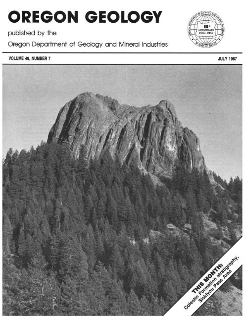
COVER PHOTO<br />
Pilot Rock, seen here from the south, is a Tertiary hornblende<br />
andesite plug located in the Siskiyou Pass area. See<br />
related article beginning on next page.<br />
The specimen shown above is typical of the pisolitic (made up<br />
of pealike grains) variety of bauxite that is commonly found in the<br />
deposits in Washington and Columbia Counties. The dark-brown<br />
pisoliths usually conlllin more than 40 percent iron and are imbedded<br />
in a lighter colored matrix that consists largely of limonite (goethlte)<br />
and gibbsite. 0<br />
78<br />
OREGON GEOWGY, VOL. 49, NO.7, JULY 1987
Volcanic stratigraphy of the Oligocene Colestin<br />
Formation in the Siskiyou Pass area of southern <strong>Ore</strong>gon<br />
By Erick A. Destland, <strong>Department</strong> oj <strong>Geology</strong>, University of <strong>Ore</strong>gon, Eugene, OR W403<br />
ABSfRACf<br />
The Oligocene Colestin Fonnation, situated at the base of the<br />
Tertiary volcanic sequence in the Western Cascades in southern<br />
<strong>Ore</strong>gon. consists of nonmarine volcaniclastic and pyroclastic deposits<br />
and lava flows. In its type area near the <strong>Ore</strong>gon-California border,<br />
the fonnation is broken down into nine infonnal members that have<br />
a combined maximum thickness of approximately 1,600 ffi. Each<br />
member is characterized by one of the follow ing lithologic types:<br />
(I) coarse volcaniclastic deposits of andesitic and basaltic composition,<br />
(2) rhyolitic pyroclastic and reoorked pyroclastic deposits, anc<br />
(3) basaltic and andesitic lava flows.<br />
The upper boundary of the Colestin Fonnalion is mapped 81<br />
a stratigraphically higher position than that mapped by Wells (1956) .<br />
The lithostratigraphic units added to the Colestin Formation are con·<br />
sistent with Wells' (1956) definition that the formation is dominant·<br />
Iy volcaniclastic.<br />
In the lower pan of the formation , the members are contained<br />
within an east-west-trending graben. The graben is bounded to the<br />
nonh by the Siskiyou Summit fault and to the south by less welldefined<br />
east-west faults located in the <strong>Ore</strong>gon-Califomia border area.<br />
During deposition of the Colestin's upper members, the graben continued<br />
to subside on the north, but at the graben's southern boundary,<br />
subsidence slowed, and volcanic material overflowed and<br />
obscured the graben faults. Prior to graben faulting and deposition<br />
of Colestin detritus, the area south ofthe Siskiyou Summit fault was<br />
uplifted. This uplift produced the north\\lard-dipping paleoslope and<br />
southward thinning of the underlying upper Eocene Payne Cliffs formation.<br />
Later graben subsidence along the Siskiyou Summit fault<br />
juxtaposed the Payne Cliffs formation and the Colestin Formation.<br />
Deposition of the volcaniclastic and pyroclastic debris within<br />
the graben occurred in an alluvial apron-type sening. The aprons<br />
developed adjacent to volcanic centers situated to the east along the<br />
Oligocene Cascade arc. Periodically, lava flows inundated the alluvial<br />
surface, but more commonly, volcanic material was deposited by<br />
laharic debris flows, stream floods, and pyroclastic flows.<br />
A distinctive type of coarse-grained volcaniclastic deposit,<br />
termed "hyperconcentrated flood flow deposits" (Smith, 1986), is<br />
common in the Colestin Formation. These deposits consist of discontinuous,<br />
horizontally bedded, very poorly soned, pebbly conglomerates<br />
and granular sandstones that are clast supponed. In the<br />
Colestin Formation, these deposits commonly grade upward from<br />
matrix-supponed debris-flow deposits (lahars).<br />
INTRODUCTION<br />
The Western Cascade Range of southern <strong>Ore</strong>gon and nonhern<br />
California consists of deeply eroded andesitic and basaltic<br />
stratovolcanoes and shield volcanoes, rhyolitic pyroclastic deposits,<br />
related intrusive rocks, and epiclastically mvorked material derived<br />
from these primary volcanic products. The volcanic strata of the<br />
Teniary volcanic sequence of the Western Cascades range in age<br />
from latest Eocene/early Oligocene to late Miocene. The initiation<br />
of Cascade volcanism has been dated at 35-40 million years (Ma)<br />
from rocks of the Western Cascades (Smith and others, 1980;<br />
Fiebelkorn and others, 1983) and from rocks at the base of the John<br />
Day Formation in central <strong>Ore</strong>gon (Swanson and Robinson, 1968;<br />
Robinson and others, 1984).<br />
This paper describes the stratigraphy and depositional history<br />
of volcanic epiclastic, pyroclastic, and lava-flow lithostratigraphic<br />
units situated at the base of the Western Cascade Teniary volcanic<br />
sequence in southern <strong>Ore</strong>gon (Figure I). Nine informal members<br />
belonging to the Oligocene Colestin Formation in its type area (Wells,<br />
1956) have been mapped over an area of about 100 Ian'. These<br />
members have a combined maximum thickness of approximately<br />
1,600 m. The area of detailed study stretches along the Western<br />
Cascade Range for 15 km from the <strong>Ore</strong>gon-California border to 4<br />
Ian nonh of Siskiyou Pass (Figure 2). This paper deals almost exclusively<br />
with the Colestin Formation in its type area.<br />
The base of the Teniary volcanic sequence of the Western<br />
Cascades is well exposed in the Siskiyou Pass area, owing to I fXiJ m<br />
of relief in the Teniary units and relatively sparse vegetation. The<br />
lower members of the Colestin Formation are exposed along streams<br />
draining the Siskiyou Mountains, and the upper members are well<br />
exposed in natural outcrops and in roadcuts along Interstate 5 and<br />
Highway 99, which transect the upper pan of the formation in the<br />
Siskiyou Pass area.<br />
The Teniary and Cretaceous rocks in this area form a<br />
northeastward-dipping homodine with dips ranging from 35 0 in the<br />
Cretaceous Hornbrook Formalion to 8 0 in the Oligocene Roxy For-<br />
-:t·<br />
.. ---Y.~.QA- - I-<br />
.:<br />
6<br />
N<br />
IDAHO<br />
I<br />
I<br />
I<br />
'i'>r~-"'n'.---,'-- - - ----.!-- ---1<br />
D High Cascad, Group<br />
~ Wuttm Ca$Ca~ GrouP:<br />
Intrusions in Block<br />
Figure 1. Geologic map of the Cascade Range showing the stud~<br />
area location and the distribution qf~stem and High Cascaile rocks<br />
(modi./iedfrom Hammond, 1979). Open circles are major andesitedacite<br />
volcanic centers.<br />
OREGON GEOLOGY, VOL. 49, NO.7, JULY 1987<br />
79
i<br />
[~:.Q\~1<br />
EXPLANATION<br />
Landslide deposlte, arrow shows direction<br />
of movement<br />
L~j<br />
Alluvium<br />
• Intrusive andesite, basalt, and dacite<br />
~ Roxy Formation, basaltic and andesite lava flows<br />
Coiestin Formation<br />
-'- Strike and dip of bedding<br />
h'¥1 Tuffaceous sandstone and tuff<br />
~ Area strike and dip from photogrammetry<br />
• Volcanic epiclastic conglomerate and breccia<br />
-'-Tel White crystal tuff<br />
&<br />
II<br />
GJ<br />
• ~<br />
Basaltic and andesitic lava flows<br />
Tuff, tuffaceous and epiclastic sandstone, volcanic breccia,<br />
and paleosol<br />
Volcanic breccia and epiclastic sandstone<br />
Basaltic and andesitic lava flows<br />
Chocolate Falls tUff, welded crystal and lithic tuff<br />
Volcanic opiclastic conglomerate and breccia<br />
-.- Fault, ball on down thrown side<br />
I:: i<br />
• Payne Cliffs Formation, arkosic & micaceous<br />
sandstone and conglomerate<br />
o Hornbrook Formation, Qrkosi~<br />
and mudstone<br />
l gaz,.!t!~ Mesozoic and pQleozoic<br />
basement complex<br />
sandstone<br />
o<br />
Kliorntters<br />
o<br />
Mllfos<br />
1<br />
Figure 2. Geologic map of the Colestin-Siskiyou Summit area.<br />
mation. In general, dips decrease to the east, away from the Klamath<br />
Mountains Province. Numerous high-angle faults offset the Tertiary<br />
and Cretaceous rocks and trend northeast, east-west, and northwest.<br />
The Siskiyou Summit fault is a major fault that trends northeastsouthwest,<br />
offsets the outcrop pattern of Cretaceous and Tertiary<br />
rocks by as much as 15 km, and brings the Colestin Formation in<br />
contact with basement rocks of the Klamath Mountains Province.<br />
The Colestin Formation was initially mapped and defined by<br />
Wells (1956) for sequences of volcaniclastic and pyroclastic rocks<br />
that crop out in scattered locations at the base of the Western Cascade<br />
Tertiary volcanic sequence in the Medford quadrangle. Wells (1956)<br />
designated an area near the town of Colestin along the California<br />
<strong>Ore</strong>gon border as the type area of the Colestin Formation. Lava flows<br />
overlying these volcaniclastic rocks were assigned to the Little Butte<br />
Volcanic Series, the base of which is represented in the Ashland<br />
Medford area by the Oligocene Roxy Formation (Wells, 1956). The<br />
base ofthe Little Butte Volcanic Series was defined by Wells (1956)<br />
as the stratigraphically first 1oo-ft-thick lava flow in the Tertiary<br />
80<br />
OREGON GEOLOGY, VOL. 49, NO.7, JULY 1987
volcanic rocks of the Western Cascades. Peck and others (1964) used<br />
Wells' (1956) Colestin and Little Butte divisions of the Tertiary<br />
volcanic rocks and mapped them to the north of the Medford<br />
quadrangle in the central <strong>Ore</strong>gon Cascades.<br />
Carlton (1972) completed a petrographic and stratigraphic study<br />
of the Colestin Formation in the Siskiyou Pass-Colestin area and<br />
also studied the formation to the south in northern Califurnia. Carlton<br />
(1972) fullowed Wells' (1956) Little Butte/Colestin boundary but apparently<br />
did not map any lithologic units in the Colestin Formation.<br />
LITHOSTRATIGRAPmC UNITS OF THE COLESTIN<br />
FORMATION<br />
In its type area, the Colestin Formation can be divided into nine<br />
informal members that consist predominantly of one of the following<br />
lithologic types: (1) volcaniclastic conglomerates and sandstones<br />
with clasts of andesitic and basaltic composition, (2) rhyolitic tuffaceous<br />
sandstones and tuffs, and (3) basaltic and andesitic lava flow<br />
sequences. These members pinch out and interfinger with each other<br />
and are largely contained in a northeast-southwest-trending graben<br />
(Figure 3). The graben is bounded to the north by the Siskiyou Summit<br />
fault and is more diffusely bounded to the south by a series of<br />
east-west faults in the <strong>Ore</strong>gon-California border area. Syndepositional<br />
graben faulting may have been widespread during deposition<br />
of the Colestin Formation and could explain the general thickening<br />
of most members toward the Siskiyou Summit fault.<br />
Member Tee<br />
A basal fluvial conglomerate tens of meters in thickness rests<br />
with angular discordance on the Hornbrook Formation in most of<br />
the study area. The unit is poorly consolidated and poorly sorted<br />
and contains cobbles and boulders of andesitic and basaltic lava flow<br />
fragments (volcanic epiclasts of Fisher, 1966) and minor amounts<br />
of quartzite and argillite cobbles. Overlying the basal conglomerate<br />
is a ledge-forming, matrix-supported volcanic breccia unit (lahar)<br />
that is up to 20 m thick. The laharic unit contains altered and<br />
unaltered cobbles and boulders of basalt and andesite in a matrix<br />
of coarse sand. To the south, this member pinches out, and the<br />
overlying member Tcft rests on the Cretaceous Hornbrook<br />
Formation.<br />
Member Teft<br />
A pyroclastic flow sequence up to 250 m thick is here informally<br />
referred to as the tuff of Chocolate Falls for exposures along<br />
Chocolate Falls Creek. The base of the tuff of Chocolate Falls consists<br />
of a lithic-rich pumice lapilli tuff. The bulk of the tuff of<br />
Chocolate Falls consists of tan crystal and pumice tuff with abundant<br />
white medium-grained plagioclase crystals and yellow pumice<br />
lapilli that are slightly elongated parallel to bedding. Most of the<br />
tuff is welded to varying degrees, and some parts display vapor phase<br />
alteration and devitrification textures. A dark-gray vitrophyre is locally<br />
present in the stratigraphic middle of the tuff sequence. This<br />
vitrophyre has an obsidianlike appearance where it is well developed.<br />
Member Telb<br />
The lower basaltic member consists of basaltic and andesitic<br />
lava flows and can be divided into two parts (Figure 3). The lower<br />
sequence is interbedded with the upper part of the tuff of Chocolate<br />
Falls, and the upper sequence overlies the tuff. These lava flow units<br />
cap most of the ridges and form dip slopes in the upper Cottonwood<br />
Valley area. The lavas consist predominantly of plagioclase<br />
and pyroxene-phyric basaltic andesites.<br />
Member Te<br />
Member Tc is an undifferentiated sequence of poorly consolidated<br />
volcanic debris flows, andesitic flow breccia, weathered<br />
volcanic siltstone, and volcaniclastic sandstone. The unit crops out<br />
very poorly and in some roadcuts resembles Quaternary colluvium<br />
or landslide debris.<br />
Member Tel<br />
Member Tcl is a heterogeneous collection of lithologic units<br />
that are well exposed in Interstate 5 and Highway 99 roadcuts along<br />
the south side of Siskiyou Pass. The base of the member is defined<br />
by a white pumice lapilli tuff that forms white, ashy-looking outcrops<br />
where it is poorly welded and tan flaggy outcrops where it<br />
is welded (Figure 4). The tuff contains fine-grained brown biotite<br />
and a small amount of carbonized plant debris and has a slightly<br />
eutaxitic foliation.<br />
AQ.ove the pumice lapilli tuff is a lO-m-thick sequence of tuffaceous<br />
sandstones and siltstones (Figure 5). Upward in this sequence<br />
of sandstones, the amount of tuffaceous material gradually decreases<br />
in favor of lava flow fragments. The tuffaceous sandstones grade<br />
upward into a 40-m-thick sequence of massive to crudely bedded<br />
brown sandstones composed of volcanic epiclastic debris (lava flow<br />
Figure 3. Composite cross section along strike of the Colestin Formation and Payne Cliffs formation. The area of Figure 4 is outlined<br />
with dashed lines.<br />
OREGON GEOLOGY, VOL. 49, NO.7, JULY 1987 81
n<br />
0ll-nra;L ,<br />
!"==========do==========,'""<br />
Figure 4. Stratigraphy of;n/omull members Tel, Teb, Tcs, and Tcts in the upper part of the Colestin Fimnation between Siskiyou Pass<br />
and the <strong>Ore</strong>gon-California border. Lettered rectangles are detailed measured sections, and venicallines are well-exposed sections that were<br />
measured approximnlely (from Bestland, J985b).<br />
fragments). In the Interstate 5 roadcuts, this unit contains numerous<br />
dark-colored strips and spots, with the strips being 011 the order of<br />
1-3 m long and 10-30 em wide. Many of the strips and spots form<br />
halos around carbonized branches. Petrographic examination reveals<br />
that the dark coloration is due to pervasive chlorite cement.<br />
Overlying the massive sandstones is a unit of unconsolidated<br />
andesitic boulder breccia that is up to 50 m thick. Scattered<br />
throughout this unit is andesitic flow breccia. Capping the boulder<br />
breccia is a weathered horizon that is locally up to 10 m thick. The<br />
weathered origin for this clayey siltstone is indicated by a gradation<br />
in clast alteration from largely unaltered clasts in the underlying<br />
breccia to a saprolite and up into a red clayey siltstone with welldeveloped<br />
ped suucrures and roo!: traces. A chemical analysis (atomic<br />
absorption) of a red bricklike horizon in the paleosol (Figure 6) gave<br />
a composition of 26 percent FelO), 47 percent Si0 2 , and 9.5 percent<br />
AI 2 0).<br />
Member Teb<br />
Basaltic and andesitic lava flows of member Tcb rest on the<br />
paleosol of member Tcl and pinch out to the north between members<br />
TcI and Tcs (Figure 4). A 3O-Ma age of a lava flow in this member<br />
was determined by Sutter (1978). The unit forms dip slopes and scattered<br />
cliffy outcrops. Member Tcb thickens abruptly to the south,<br />
whereas member TcI thins abruptly to the south. Paleosols, consisting<br />
of red and white silty claystone with well-developed ped structures,<br />
overlie the altered tops of lava flows in member Tcb along<br />
Highway 99, 2 km south of Siskiyou Pass. Near the California<br />
<strong>Ore</strong>gon border, member Tcb is approximately 200 m thick.<br />
Member Tcs<br />
Member Tcs, which consists of volcanic epiclastic sandstones,<br />
conglomerates, and lahars of andesitic and basaltic composition,<br />
is well exposed in roadcuts on Interstate 5 and Highway 99 along<br />
Siskiyou Pass. Channelized conglomerates and sandstones are common<br />
in this unit. Channel orientations and rare cobble imbrication<br />
in these deposits indicate a paleocurrent direction to the southwest.<br />
To the south of Siskiyou Pass and paralleling Highway 99, member<br />
Tcs pinches out between members Tcb and Tcts.<br />
Many of the matrix-supported boulder and cobble lahar units<br />
grade upward into clast-supported, discontinuously bedded, pebbly<br />
conglomerates and granular sandstones (Figures 7, 8, and 9).<br />
The bedding in these conglomerates is produced by size variation<br />
and grading of the sand and gravel. These types of bedded, c1astsupponed<br />
conglomerates are termed "hyperconcentrated flood flow<br />
deposits" by Smith (1986) and are thought to represent a type of<br />
flow that is intermediate between the en-masse flow of laharic debris<br />
flows and normal fluvial flow.<br />
Member Tel<br />
A distinctive white crystal ruff is sandwiched between the darker<br />
colored volcaniclastic sandstones and conglomerates of member Tcs.<br />
This unit was mapped separately as member Tct (Figure 10). The<br />
tuff has a maximum thickness of 10 m in the nonhem pan of its<br />
outcrop area and thins abruptly to the south. Lapilli-sized carbonized<br />
plant fragments are abundant and are generally aligned subparallel<br />
to bedding, as are the numerous plagioclase and quartz crystals.<br />
Petrographic examination of the vitric matrix of the tuff indicates<br />
that the glass shards are weakly welded and almost completely altered<br />
to zeolites (heulandite and clinoptilolite). Scanning electron<br />
microscope examination of the carbonized plant material reveals it<br />
to be composed of charcoalized wood fragments. Charcoal is in-<br />
Figure 5. RoadCUI along Highway 99, 2* mi south of Siskiyou<br />
Pass, exposing the pumice Japilli tuff that marks the base of informal<br />
member Tel. The pumice tuff is cut by a channel containing<br />
coarse, well-cememed tuffaceous salJdslone. Hammer (see arrow)<br />
is just under the channel-pumice luff contact.<br />
82<br />
OREGON GEOLOGY, VOL. 49, NO.7, JULY 1987
Figure 6 Roodcut along Highway 99, 2 mi south of Siskiyou<br />
Pass, exposing contact between the paleosol at the top of informal<br />
member Tel and favaflows of informal member Teb. Arrow on right<br />
side points to bricklike ferruginous horizon in paleosol; arrow on<br />
left side points to red paleosol interbed between lava flows.<br />
dicated by fused and distorted cell walls and results from incomplete<br />
burning at a minimum temperature of around 290 OC (Cope and<br />
Chaloner, 1980).<br />
Member Tcts<br />
This member consists of approximately 250 m of tuffaceous<br />
sandstones, siltstones, and intercalated vitric and pumiceous tuffs.<br />
The unit as a whole is light colored and, compared to other Colestin<br />
units, is finer grained and less well exposed. The white vitric<br />
tuff and the underlying tuffaceous sandstones of member Tcts are<br />
tentatively correlated with Vance's (1984) Soda Springs member (J.<br />
Vance, personal communication, 1984), which Vance (1984) dated<br />
at Tl Ma.<br />
A stratigraphic sequence consisting of lacustrine tuffaceous<br />
claystones, organic-rich layers with tuffaceous claystones, and welded<br />
pumice lapilli ignimbrite is exposed along Beacon Rock. The lightpink<br />
pumice lapilli tuff has a well-defined eutaxitic foliation and<br />
abundant biotite, fel dspar, and quartz crystals in a welded vitric<br />
groundmass.<br />
Capping the sequence of tuffaceous sandstones is a distinctive<br />
Figure 8. Closeup of poorly soned, granular sandstones (informal<br />
member Tcs) of Figure 71hal are interpreted as hyperconeentrated<br />
flood flow deposits.<br />
white vitric tuff. The most widespread ruff has a brilliant white color<br />
and contains sparse plagioclase crystals and pumice lapilli in an<br />
unwelded vitric groundmass. Associated with this tuff is a lightgray<br />
welded and locally lithophysal tuff containing sparse, altered<br />
feldspar crystals. The gray tuff represents a welded part of the capping<br />
white tuff.<br />
The capping white vitric tuff can be traced th roughout the map<br />
area. It overlies the Siskiyou Summit fault on the west side of Buck<br />
Rock with no apparent offset. This relationship demonstrates that<br />
movement of the Siskiyou Summit fault, at least in this area, ended<br />
before deposition of this tuff.<br />
PAYNE CLIFFS FORMATION<br />
A discussion of the Colestin Fonnation is not complete without<br />
mention of the closely related Payne Cliffs fonnation (infonnally<br />
named by McKnight, 1971, 1984). North of the Siskiyou Summit<br />
fault in the Ashland-Medford area, the upper Eocene Payne Cliffs<br />
fonnation of McKnight (1971, 1984) lies at the base of the Teritary<br />
sequence; south of the fault, however, the Colestin Formation lies<br />
at the base of the Tertiary section. The outcrop extent of the Payne<br />
Cliffs fonnation thins to the south and ends at the Siskiyou Summit<br />
fault (Figure 2). The stratigraphic relations between the Payne Cliffs<br />
fonnation and the Colestin Fonnation are not well understood. The<br />
upper volcaniclastic pan of the Payne Cliffs formation may be coeval<br />
with some pan of the Colestin Fonnation; however, the exact correlation<br />
is not known .<br />
Figure 7. Roadcut along Highway 99, half a mile nonh of<br />
Siskiyou Pass, expoSing an indistinctly planar bedded granular<br />
sandstone-pebbly conglomerate sequence (informal member Tcs) that<br />
grades down into the matrix-supponed volcanic breccia shown in<br />
Figure 9. Arrow points to the coarse-grained basal /ayer of the lightcolored<br />
unit that is the white crystaltujJ (informal member Tct).<br />
Outcrop is approximately 10 m thick.<br />
Figure 9. Closeup of matrix-suppo ned volcanic breccia (/ahar;<br />
informal member Tcs) that grades up into the granular sandstones<br />
of Figure 8.<br />
OREGON GEOLOGY, VOL. 49, NO, 7, JULY 1987<br />
83
The formation consists predontinantly of arkosic and micacecus<br />
sandstones and conglomerates with quanzite, argillite, metamorphic,<br />
and granitic clasts. The upper pan of the formation is dominated<br />
by volcaniclastic material. McKnight (1971, 1984) has identified a<br />
gradation from arkosic and micaceous sandstones and conglomerates<br />
in the lower pan of the Payne Cliffs formation to volcaniclastic and<br />
tuffaceous sandstones, conglomerates. and siltstones in the upper<br />
pan of the formation. The volcaniclastic deposits at the very top<br />
of the formation examined in this study can be grouped into those<br />
with and those without mllSCOVite. The Colestin Formation does not<br />
contain muscovite in any quantity. Abundant muscovite in Payne<br />
Cliffs volcaniclastic material indicates that nonh of the Siskiyou Summit<br />
fault, Cascade material was mixed with KJamath Mountain<br />
detritus. The volcaniclastic deposits without muscovite are very<br />
similar in composition, color, grain size, and soning to many of<br />
the sandstones in the Colestin Formation. However, none of the<br />
members recognized in the Colestin Formation were identified in<br />
the upper volcaniclastic pan of the Payne Cliffs fonnation.<br />
The arkosic sandstones and conglomerates were deposited by<br />
a nonh'NIrd-flowing braided river system (McKnight, 1971, 1984).<br />
During deposition of the Payne Cliffs formation, an uplifted source<br />
area was present to the south in the KJamath Mountains (McKnight,<br />
1971, 1984). A southern source area is indicated from the oonhwarddipping<br />
paleoslope and nonhward thickening of the fonnation<br />
(McKnight, 1971, 1984). The problem is: What happened to the formation<br />
in the Siskiyou Summit area'! One interpretation is that the<br />
Payne Cliffs formation was deposited in the Siskiyou Summit area.<br />
which was subsequently uplifted , causing the formation to be eroded.<br />
This interpretation fits with the thinning of the Payne Cliffs fonnation<br />
to the south, which could have resulted from beveling of the<br />
fonnation during uplift. During deposition of the Colestin formation,<br />
however, the area south of the Siskiyou Summit fault was<br />
downfaulted, thereby containing Colestin detritus. 1berefore, a reversal<br />
of movement is indicated for the Siskiyou Pass area, with uplift<br />
occurring during the deposition of the Payne Cliffs formation and<br />
down fault ing occurri ng during Colestin deposition.<br />
COLFSI'IN-ROXY FORMATION BOUNDARY<br />
The Roxy Formation in the study area consists predominantly<br />
of dark-colored, dense plagioclase-phyric pyroxene basalts and<br />
andesites and onJy minor amounts of volcaniclastic and pyroclastic<br />
deposits. These lava flows cap ridges and form prominent dip slopes<br />
around Pilot Rock. Many landslides originate at the contact between<br />
rhe tuffs of member Tcts and the overlying basalts. Area strike and<br />
Figure IU RoadCUI along the east side of Siskiyou Summit on<br />
Interstate 5, exposing a channel cut into volcanic conglomeraus and<br />
breccia of infomwl membu 'R:s that is filled fly the white crystal<br />
tuff (infomwl member Tct). Arrow points to carbonized plant debris<br />
in jnjomwl member Tct.<br />
dip measurements using photogrammetric techniques (Ray. 1960)<br />
indicate that a sligh! angular discordance exists, at least locally. between<br />
these lava flows and the underlying Coles!in Formation units<br />
(Figure 2).<br />
The boundary between the Colestin and Roxy Fonnations by<br />
the author (Bestland, 1985a,b) and in this repon differs from the<br />
boundary mapped l:ry Wells (1956). Carlton (1972), and Smith and<br />
Page (1977). The boundary between the Little Butte Volcanic Series<br />
and the Colestin Formation was defined l:ry We lls (1956) as being<br />
the stratigraphically first lOO-ft-thick lava flow. In the Siskiyou Pass<br />
area, the boundary between the Colestin Fonnation and the Little<br />
Butte Volcanic Series is recognized in this study to be at the contact<br />
of the white tuffs of member Tcts and the prominent cliff-(orming<br />
basaltic lava flows designated as Roxy Formation. Volcanic strata<br />
previously assigned 10 the basal Roxy Formation l:ry Wells (1956)<br />
consist chiefly of volcaniclastic and pyroclastic rocks. The lithology<br />
of these rocks is consistent with Wells' (1956) original designa!ion<br />
that the Colestin Formation consists predontinantly of volcaniclastic<br />
and pyroclastic deposits.<br />
Wells' (1956) Colestin-Little Butte Volcanic Series boundary<br />
was mapped l:ry previous \VOrkers at the base of member Tcb. The<br />
stratigraphic find ings of this study demonstrate that the lava flows<br />
of member Tcb pinch out to the nonh between mlcaniclastic deposits<br />
ofColestin members TcI and Tcs (Figure 4). In the area of this pinchout,<br />
previous \VOrkers have mapped a fault between the lava flows<br />
of member Tcb and the volcaniclastic rocks of members TcI and<br />
Tcs (Elliott, 1971; Carlton 1972; Smith and Page, 1977; Smi!h and<br />
others, 1982). A thick paleosol horizon can be traced across the<br />
pinch-out of member Tcb. Syndepositional faults are located in the<br />
vicinity of the pinch-out of member Tcb. These faults cut member<br />
TcI but do nm noticeably offset the overlying members Tcs and Tct<br />
(Figure 4).<br />
Future work on the lower parts of the Teniary volcanic sequence<br />
in nonhern California may reveal that members Tcb, Tcs, and Tcts<br />
are of formational extent. Additional mapping to the south of the<br />
California border is needed to substantiate this suggestion and ~ld<br />
hinge on whether the pronounced disconfonnity, represented by the<br />
strongly· ferrugin ized paleosol, can be traced to the south.<br />
DISCUSSION<br />
Volcanic apron facies<br />
The depositional environment of the Colestin Formation was<br />
interpreted on the basis of detailed stratigraphic and sedimentological<br />
\VOrk on the upper pan of the formation (Bestland and Boggs, 1985).<br />
This \VOrk has resolved many of the lateral stratigraphic problems<br />
in a nonh-soutl! (jirection (Figure 4) . Unfortunately, proximal-distal<br />
facies relatioriships are not obvious because the source area for the<br />
Colestin deposits was located to the east of the formation's nonhsouth<br />
outcrop pattern. VolcaniclaSlic deposits and facies models<br />
srudied by other \VOrkers can be compared to the sedimentary stnrctures<br />
and textures and the stratigraphic relationships of the Colestin<br />
deposits.<br />
\blcaniclastic facies models that relate the relative distance from<br />
a volcanic center(s) have been made l:ry Swanson (1966), Parsons<br />
(1969), Smedes and Prostka (1972), and Vessell and Davies (1981).<br />
The term "volcaniclastic apron fac ies" 'NIS developed from these<br />
studies and refers to volcaniclastic deposits that encircle, or partially<br />
encircle, volcanic centers of the stralovolcano type. The apron<br />
facies is analogous to an alluvial fan facies in coarseness of deposits<br />
and proximity to source area.<br />
The lithology and sedimentary characteristics of the members<br />
in the upper pan of the Colestin Formation compare we ll to the<br />
medial volcaniclastic facies of Vesse ll and Davies (1981) and to the<br />
coarse alluvial fac ies of Smedes and Prostka (1972). Distinctive<br />
characteristics recognized in the upper Colestin deposits that are<br />
indicative of apron facies aside from the coarseness, poor sorting.<br />
and high angUlarity of the clasts include well-developed channels.<br />
84<br />
OREGON GEOLOGY, VOL, 49, NO, 7, JULY 1987
... # •••<br />
scarcity of fine-grained deposits, and lateral facies variations that<br />
delineate distinctive sequences composing the apron. Numerous large<br />
channels are present and are commonly filled with poorly sorted<br />
to unsorted conglomerate and sandstone. The channels lack lateral<br />
channel migration structures, and some appear to have been cut and<br />
filled during the same flood event.<br />
Depositional reconstruction of the upper Colestin Formation<br />
Members Tcl, Tcs, and Tcts represent three volcanic sequences<br />
of the apron that were developed adjacent to volcanic centers situated<br />
to the east along the Oligocene Cascade arc (Figure 11). Member<br />
Tcl accumulated in a small graben that was orientated roughly eastwest.<br />
Syndepositional graben faulting complicated the stratigraphy<br />
and produced a local, but thick, accumulation of volcanic sandstones<br />
and breccia. After the small graben was filled, a prolonged period<br />
of nondeposition (volcanic quiescence) and weathering followed,<br />
producing the paleosol that caps member Tcl.<br />
Effusive basaltic and andesitic volcanism followed the volcanic<br />
hiatus. These lava flows of member Tcb lap onto member Tcl to<br />
the north and thicken considerably to the southeast. Member Tcb<br />
lavas can be interpreted as valley fill or as the flank of a shield<br />
volcano. Because member Tcb thickens dramatically to the south<br />
and is onlapped to the north by member Tcs, member Tcb is interpreted<br />
as the flank of a shield volcano.<br />
Weathering and soil formation on the upper surface of member<br />
Tcb was followed by andesitic volcanism of member Tcs. This<br />
volcanism produced the andesitic debris contained in the lahars and<br />
pebbly sandstones of member Tcs. The volcanic center that produced<br />
member Tcs was located to the northeast of the map area<br />
(Figure 11). This interpretation is indicated by the thickening of<br />
member Tcs to the north, the lapping of member Tcs onto member<br />
Tcb, and the southwest-northeast channel orientations in this unit.<br />
Member Tcts represents a large alluvial apron that consists<br />
almost totally of rhyolitic pyroclastic debris of both ignimbrite and<br />
waterlain origin. The unit consists of sand-sized material and is<br />
distinctly finer grained than other Colestin deposits. The grain size<br />
could represent a more distal source compared to other Colestin<br />
2001<br />
1<br />
N<br />
~<br />
dissected andesi tic center<br />
units, but the sediment size probably reflects the grain size of the<br />
original pyroclastic material. The pyroclastic volcanism of member<br />
Tcts ended abruptly and was followed by effusive basaltic volcanism<br />
of the Roxy Formation lava flows.<br />
SUMMARY AND CONCLUSIONS<br />
Each lithostratigraphic unit of the Colestin Formation records<br />
a distinct episode of volcanism both in the composition of the<br />
volcanic products and in the mode of volcaniclastic deposition.<br />
Andesitic and basaltic volcanism generated largely effusive volcanic<br />
products, which, in turn, were the source material for boulder and<br />
cobble debris flows and pebbly hyperconcentrated flood flows.<br />
Rhyolitic pyroclastic volcanism produced easily erodible material<br />
that was deposited on the alluvial aprons by sandy stream floods<br />
and pyroclastic flows.<br />
The rapid lateral facies changes that are ubiquitous in the Colestin<br />
Formation developed from deposition around active volcanoes.<br />
The lobelike depositional pattern of the members reflects the episodic<br />
nature of volcanic eruptions and the shifting of activity between<br />
volcanoes along the arc. Rapid erosion of erupted material from steep<br />
flanks of volcanoes produced rapid deposition on the alluvial apron.<br />
Between periods of deposition, the alluvial apron was eroded and<br />
weathered. Another factor that further complicated the stratigraphic<br />
interpretation was the syndepositional faulting that occurred during<br />
the aggradation of the apron. All of these factors produced a complex<br />
local stratigraphy that was worked out by field tracing of marker<br />
units (pyroclastic flows, lava flow sequences, and paleosols) and mapping<br />
of lithologic units.<br />
All of the members, except member Tcl, are compositionally<br />
uniform. They are either rhyolitic tuffs and tuffaceous sediments<br />
or basalt-basaltic andesite lava flows and/or lahars. The observation<br />
that the members are either rhyolitic or basaltic and andesitic<br />
agrees with Lowenstern's (1986) geochemical data, which give a<br />
roughly bimodal chemical distribution for the Colestin lava flows<br />
and tuffs.<br />
The syndepositional east-west faulting in the Colestin Formation<br />
may be widespread in the Western Cascades of southern <strong>Ore</strong>gon.<br />
volcano<br />
0· .. ···<br />
_.•.. -.<br />
r-<br />
Ed ~ '"<br />
~ '"<br />
Ed _ ··...,..<br />
.. - .<br />
.,..-.<br />
lava flows<br />
boulder brecc ia<br />
epiclastic deposits<br />
pyroclastic deposits<br />
tuffaceous sandstone<br />
Figure 11. Depositional reconstruction of informal members Tcb, Tcs, and Tcts during deposition of informal member Tcts.<br />
OREGON GEOLOGY, VOL. 49, NO.7, JULY 1987<br />
8S
A regional north-south extensional stress, which formed east-westtrending<br />
grabens, could explain the pattern of basaltic and rhyolitic<br />
rocks at the base of the Western Cascades that is present to the north<br />
of the type area of the Colestin Formation. North of the Siskiyou<br />
Summit fault, a thick sequence of basaltic lava flows is present at<br />
the base of the Western Cascades (Roxy Formation). To the north<br />
of these basalts, however, a thick sequence of rhyolitic pyroclastic<br />
rocks, principally, the Bond Creek ignimbrite of Smith and others<br />
(1980), occurs at the base ofthe Western Cascades. These relations<br />
suggest that a regional east-west tectonic stress influenced the initial<br />
character of volcanism in the Western Cascades of southern<br />
<strong>Ore</strong>gon. On the other hand, the graben faulting in the Colestin area<br />
may be the result of the uplift of the Klamath block and not related<br />
to this lithologic pattern at the base of the Western Cascades.<br />
ACKNOWLEDGMENTS<br />
The writer wishes to thank S. Boggs, P.E. Hammond, and G.J.<br />
Retallack for critically reviewing the paper. This paper is an<br />
outgrowth of a master's thesis completed at the University of <strong>Ore</strong>gon<br />
and funded in part by the <strong>Ore</strong>gon <strong>Department</strong> of <strong>Geology</strong> and<br />
Mineral Industries, the Baldwin Fellowship, and the Student<br />
Research Fund at the University of <strong>Ore</strong>gon.<br />
REFERENCES CITED<br />
Bestland, E.A., 1985a, Volcaniclastic and pyroclastic alluvial fan facies and<br />
boundary redefinition of the Oligocene Colestin Formation, southern<br />
<strong>Ore</strong>gon Western Cascades [abs.]: <strong>Ore</strong>gon Academy of Science Proceedings,<br />
v. 21, p. 84.<br />
---1985b, Stratigraphy and sedimentology of the Oligocene Colestin Formation,<br />
Siskiyou Pass area, southern <strong>Ore</strong>gon: Eugene, <strong>Ore</strong>g., University<br />
of <strong>Ore</strong>gon master's thesis, 150 p.<br />
Bestland, E.A., and Boggs, S., Jr., '1985, Volcaniclastic and pyroclastic<br />
alluvial plain and fan facies in the Oligocene Colestin Formation, southern<br />
<strong>Ore</strong>gon Western Cascades [abs.]: Geological Society of America Abstracts<br />
with Programs, v. 17, no. 6, p. 341.<br />
Carlton, R.w., 1972, Stratigraphy, petrology, and mineralogy of the Colestin<br />
Formation in southwest<strong>Ore</strong>gon and northern California: Corvallis,<br />
<strong>Ore</strong>g., <strong>Ore</strong>gon State University doctoral dissertation, 208 p.<br />
Cope, M.I, and Chaloner, W.G., 1980, Fossil charcoal as evidence of past<br />
atmospheric composition: Nature, v. 283, p. 647-649.<br />
Elliott, M.A., 1971, Stratigraphy and petrology of the Late Cretaceous rocks<br />
near Hilt and Hornbrook, Siskiyou County, California, and Jackson County,<br />
<strong>Ore</strong>gon: Corvallis, <strong>Ore</strong>g., <strong>Ore</strong>gon State University doctoral dissertation,<br />
171 p.<br />
Fiebelkorn, R.B., Walker, G.w., Macleod, N.S., McKee, E.H., and Smith,<br />
IG., 1983, Index to K-Ar determinations for the State of <strong>Ore</strong>gon:<br />
Isochron/West, no. 37, p. 3-60.<br />
Fisher, R.Y., 1966, Rocks composed of volcanic fragments and their classification:<br />
Earth-Science Reviews, v. 1, no. 4, p. 287-298.<br />
Hammond, P.E., 1979, A tectonic model for the evolution of the Cascade<br />
Range, in Armentrout, 1M., Cole, M.R., and TerBest, H., Jr., eds.,<br />
Cenozoic paleogeography of the western United States: Pacific Coast<br />
Paleogeography Symposium 3, Anaheim, Calif., Society of Economic<br />
Paleontologists and Mineralogists, Pacific Section, p. 219-237.<br />
Lowenstern, IB., 1986, Petrology, paleomagnetism, and tectonic significance<br />
ofthe lavas of the Colestin Formation, Jackson County, <strong>Ore</strong>gon: Hanover,<br />
N.H., Dartmouth College undergraduate thesis, 61 p.<br />
McKnight, B.K., 1971, Petrology and sedimentation of Cretaceous and Eocene<br />
rocks in the Medford-Ashland region, southwestern <strong>Ore</strong>gon: Corvallis,<br />
<strong>Ore</strong>g., <strong>Ore</strong>gon State University doctoral dissertation, 196 p.<br />
---1984, Stratigraphy and sedimentology of the Payne Cliffs formation,<br />
southwestern <strong>Ore</strong>gon, in Nilsen, T.H., ed., <strong>Geology</strong> of the Upper<br />
Cretaceous Hornbrook Formation, <strong>Ore</strong>gon and California: Society of<br />
Economic Paleontologists and Mineralogists, Pacific Section, Field Trip<br />
Guidebook 42, p. 187-194.<br />
Parsons, W.H., 1969, Criteria for the recognition of volcanic breccias: Review,<br />
in Larsen, L.H., Prinz, M., and Manson, v., eds., Igneous and metamorphic<br />
geology (Poldervaart volume): Geological Society of America<br />
Memoir 115, p. 263-304.<br />
Peck, D.L., Griggs, A.B., Schlicker, H.G., Wells, EG., and Dole, H.M.,<br />
1964, <strong>Geology</strong> of the central and northern parts of the Western Cascade<br />
Range in <strong>Ore</strong>gon: U.S. Geological Survey Professional Paper 449, 56 p.<br />
Ray, R.G., 1960, Aerial photographs in geologic interpretation and mapping:<br />
U.S. Geological Survey Professional Paper 373, 230 p.<br />
Robinson, P.T., Brem, G.E, and McKee, E.H .. 1984, John Day Formation<br />
of <strong>Ore</strong>gon: A distal record of early Cascade volcanism: <strong>Geology</strong>, v. 12,<br />
no. 4, p. 229-232.<br />
Smedes, H.W., and Prostka, H.I, 1972, Stratigraphic framework of the Absaroka<br />
Volcanic Supergroup in the Yellowstone National Park region:<br />
U.S. Geological Survey Professional Paper 729-C, 33 p.<br />
Smith, G.A., 1986, Coarse-grained nonmarine volcaniclastic sediment: Terminology<br />
and depositional process: Geological Society of America<br />
Bulletin, v. 97, no. 1, p. 1-10.<br />
Smith. IG., and Page, N.I, 1977, Preliminary reconnaissance geologic map<br />
of part of Jackson County, <strong>Ore</strong>gon: U.S. Geological Survey Open-File<br />
Report 77-318, scale 1:250,000.<br />
Smith, IG., Page, N.J., Johnson, M.G., Moring, B.c., and Gray, E, 1982,<br />
Preliminary geologic map of the Medford lOx 2 0 quadrangle, <strong>Ore</strong>gon<br />
and California: U.S. Geological Survey Open-File Report 82-955, scale<br />
1:250,000.<br />
Smith, IG., Sawlan, M.S., and Katcher, A.C., 1980, An important lower<br />
Oligocene welded-tuff marker bed in the Western Cascade Range of<br />
southern <strong>Ore</strong>gon [abs.]: Geological Society of America Abstracts with<br />
Programs, v. 12, no. 3, p. 153.<br />
Sutter, J.E, 1978, K/Ar ages of Cenozoic volcanic rocks from the <strong>Ore</strong>gon<br />
Cascades west of 121 0 30': Isochron/West, no. 21, p. 15-21.~.<br />
Swanson, D.A., 1966, Tieton Volcano, a Miocene eruptive center in the<br />
southern Cascade Mountains, Washington: Geological Society of America<br />
Bulletin, v. 77, no. 11, p. 1293-1314.<br />
Swanson, D.A., and Robinson, P.T., 1968, Base of the John Day Formation<br />
in and near the Horse Heaven mining district, north-central <strong>Ore</strong>gon, in<br />
Geological Survey research 1968, chapter D: U.S. Geological Survey<br />
Professional Paper 600-D, p. 0154-0161.<br />
Vance, IA., 1984, The lower Western Cascades volcanic group in northern<br />
California, in Nilsen, T.H., ed., <strong>Geology</strong> of the Upper Cretaceous Hornbrook<br />
Formation, <strong>Ore</strong>gon and California: Society of Economic Paleontologists<br />
and Mineralogists, Pacific Section, Field Trip Guidebook 42,<br />
p. 195-196.<br />
Vessell, R.K., and Davies, D.K., 1981, Nonmarine sedimentation in an active<br />
forearc basin: Society of Economic Paleontologists and Mineralogists<br />
Special Publication 31, p. 31-45.<br />
Wells, EG., 1956, <strong>Geology</strong> of the Medford quadrangle, <strong>Ore</strong>gon-California:<br />
U.S. Geological Survey Geologic Quadrangle Map GQ-89, scale<br />
1:96,000. D<br />
New bibliography supplement on <strong>Ore</strong>gon<br />
geology released<br />
Bibliographic information on the geology and mineral resources<br />
of <strong>Ore</strong>gon is now available for literature through 1984. The <strong>Ore</strong>gon<br />
<strong>Department</strong> of <strong>Geology</strong> and Mineral Industries (DOGAMI) has<br />
published the eighth supplement in its series Bibliography of the<br />
<strong>Geology</strong> and Mineral Resources of <strong>Ore</strong>gon as DOGAMI Bulletin<br />
lO3.<br />
Produced in cooperation with GeoRef, the computerized information<br />
system of the American Geological Institute, the 176-page<br />
document continues the periodic additions to the original 1936 work<br />
by R.C. Treasher and E.T. Hodge. The bibliography contains an<br />
author list with approximately 2,200 titles for the period of 1980<br />
through 1984 and cross-references these entries in subject, county,<br />
and rock formation indexes.<br />
The new DOGAMI Bulletin lO3, Bibliography of the <strong>Geology</strong><br />
and Mineral Resources of <strong>Ore</strong>gon, Eighth Supplement, January 1,<br />
1980, to December 31, 1984, is now available at the <strong>Ore</strong>gon <strong>Department</strong><br />
of <strong>Geology</strong> and Mineral Industries, 9lO State Office Building,<br />
1400 SW Fifth Avenue, Portland, OR 97201. The purchase price<br />
is $7. Orders under $50 require prepayment. 0<br />
86<br />
OREGON GEOLOGY, VOL. 49, NO.7, JULY 1987
GEOLOGICAL MAP SERIES<br />
AVAILABLE DEPARTMENT PUBLICATIONS<br />
Price No, copies Amount<br />
GMSA: <strong>Ore</strong>gon gravity maps, onshore and offshore. 1967 .. .. .. ... .. .. .. .. .. . .. .. .. .. .. ... .. .. .. ..... .. .. . .. .. .. $ 3.00<br />
GMS-5: Geologic map, Powers 15-minute quadrangle, Coos annd Curry Counties. 1971 ............................. 3.00<br />
GMS-6: Preliminary report on geology of part of Snake River canyon. 1974 6.50<br />
GMS-8: Complete Bouguer gravity anomaly map, central Cascade Mountain Range, <strong>Ore</strong>gon. 1978. ... .. .. ... .. .. .. .. ... 3.00<br />
GMS-9: Total-field aeromagnetic anomaly map, central Cascade Mountain Range, <strong>Ore</strong>gon. 1978 .................. 3.00<br />
GMS-IO: Low- to intermediate-temperature thermal springs and wells in <strong>Ore</strong>gon. 1978 3.00<br />
GMS-12: Geologic map of the <strong>Ore</strong>gon part of the Mineral 15-minute quadrangle, Baker County. 1978 .... .. .... 3.00<br />
GMS-13: Geologic map, Huntington and part of Olds Ferry 15-min. quadrangles, Baker and Malheur Counties. 1979.. 3.00<br />
GMS-14: Index to published geologic mapping in <strong>Ore</strong>gon, 1898-1979. 1981. . .. ....... 7.00<br />
GMS-15: Free-air gravity anomaly map and complete Bouguer gravity anomaly map, north Cascades, <strong>Ore</strong>gon. 1981 3.00<br />
GMS-16: Free-air gravity anomaly map and complete Bouguer gravity anomaly map, south Cascades, <strong>Ore</strong>gon. 1981.............. 3.00<br />
GMS-17: Total-field aeromagnetic anomaly map, south Cascades, <strong>Ore</strong>gon. 1981 3.00<br />
GMS-18: <strong>Geology</strong> of Rickreall, Salem West, Monmouth, and Sidney 7V,-min. quads., Marion/Polk Counties. 1981 5.00<br />
GMS-19: <strong>Geology</strong> and gold deposits map, Bourne 7V,-minute quadrangle, Baker County. 1982.. 5.00<br />
GMS-20: Map showing geology and geothermal resources, soutbern half, Burns 15-min. quad., Harney County. 1982 5.00<br />
GMS-21: <strong>Geology</strong> and geothermal resources map, Vale East 7V,-minute quadrangle, Malheur County. 1982. ... .. ..... 5.00<br />
GMS-22: <strong>Geology</strong> and mineral resources map, Mount Ireland 7'h-minute quadrangle, Baker/Grant Counties. 1982 5.00<br />
GMS-23: Geologic map, Sheridan 7V,-minute quadrangle, Polk/Yamhill Counties. 1982. 5.00<br />
GMS-24: Geologic map, Grand Ronde 7V,-minute quadrangle, Polk/Yantbill Counties. 1982. 5.00<br />
GMS-25: <strong>Geology</strong> and gold deposits map, Granite 7V,-minute quadrangle, Grant County. 1982.. 5.00<br />
GMS-26: Residual gravity maps, northern, central, and southern <strong>Ore</strong>gon Cascades. 1982. 5.00<br />
GMS-27: Geologic and neotectonic evaluation of north-central <strong>Ore</strong>gon: The Dalles I °x2 ° quadrangle. 1982 6.00<br />
GMS-28: <strong>Geology</strong> and gold deposits map, Greenhorn 7'h-minute quadrangle, Baker/Grant Counties. 1983 5.00<br />
GMS-29: <strong>Geology</strong> and gold deposits map, NE'4 Bates 15-minute quadrangle, Baker/Grant Counties. 1983 5.00<br />
GMS-30: Geologic map, SE'4 Pearsoll Peak 15-minute quadrangle, Curry/Josephine Counties. 1984 6.00<br />
GMS-31: <strong>Geology</strong> and gold deposits map, NWI4 Bates 15-minute quadrangle, Grant County. 1984 5.00<br />
GMS-32: Geologic map, Wilhoit 7V,-minute quadrangle, Clackamas/Marion Counties. 1984 4.00<br />
GMS-33: Geologic map, Scotts Mills 7'h-minute quadrangle, Clackamas/Marion Counties. 1984. 4.00<br />
GMS-34: Geologic map, Stayton NE 7V,-minute quadrangle, Marion County. 1984. 4.00<br />
GMS-35: <strong>Geology</strong> and gold deposits map, SWI4 Bates 15-minute quadrangle, Grant County. 1984. 5.00<br />
GMS-36: Mineral resources map of <strong>Ore</strong>gon. 1984 ............................................................... 8.00<br />
GMS-37: Mineral resources map, offshore <strong>Ore</strong>gon. 1985. . . . . . . . . . . . . . . . . . . . . . . . . . . . . . . . . . . . . . . . . . . . . . . . 6.00<br />
GMS-38: Geologic map, NW'4 Cave Junction 15-minute quadrangle, Josephine County. 1986 .......... 6.00<br />
GMS-39: Geologic bibliography and index maps, ocean floor and continental margin off <strong>Ore</strong>gon. 1986 ... .. .. .. . 5.00<br />
GMSAO: Total-field aeromagnetic anomaly maps, Cascade Mountain Range, northern <strong>Ore</strong>gon. 1985 4.00<br />
GMSA2: Geologic map, ocean floor off <strong>Ore</strong>gon and adjacent continental margin. 1986 8.00<br />
GMSA3: Geologic map, Eagle Butte and Gateway 7'/2-min. quads., Jefferson/Wasco Co. 1987 ......... $4.00; as set with GMS-44 & -45 $10.00<br />
NEW I GMS-44: Geologic map, Seekseequa Junction and Metolius Bench 7V2-min. quads., Jefferson Co. 1987 .. $4.00; as set with GMS-43 & A5 $10.00<br />
GMSA5: Geologic map, Madras West and Madras East 7'/,-min. quads., Jefferson County. 1987. . ... $4.00; as set with GMS-43 & A4 $10.00<br />
GMSA9: Map of <strong>Ore</strong>gon seismicity, 1841-1986. 1987. 3.00<br />
GMS-50: Geologic map, Drake Crossing 7V,-minute quadrangle, Marion County. 1986 . .. ... .. .. .. ... .. .. .. .. .. ... 4.00<br />
GMS-51: Geologic map, Elk Prairie 7V,-minute quadrangle, Marion/Clackamas Counties. 1986 4.00<br />
OTHER MAPS<br />
Reconnaissance geologic map, Lebanon 15-minute quadrangle, Linn/Marion Counties. 1956. 3.00<br />
Geologic map, Bend 30-minute quad., and reconnaissance geologic map, central <strong>Ore</strong>gon High Cascades. 1957 . 3.00<br />
Geologic map of <strong>Ore</strong>gon west of 121st meridian (U.S. Geological Survey Map 1-325). 1961 ............................ 6.10<br />
Geologic map of <strong>Ore</strong>gon east of 121st meridan (U.S. Geological Survey Map 1-902). 1977 ............ 6.10<br />
Landforms of <strong>Ore</strong>gon (relief map, 17x12 in.). 1.00<br />
<strong>Ore</strong>gon Landsat mosaic map (published by ERSAL, OSU). 1983<br />
.$8.00 over the counter, $11.00 mailed<br />
Geothermal resources of <strong>Ore</strong>gon (map published by NOAA). 1982.............. ..... .. .. .. ... .. .. .. .. ... .. ... 3.00<br />
Geological highway map, Pacific Nothwest region, <strong>Ore</strong>gon/Washington/part of Idaho (published by AAPG). 1973 . 5.00<br />
Mist Gas Field Map, showing well locations, revised 10/86 (DOGAMI Open-File Report 0-84-2, ozalid print). 5.00<br />
Northwest <strong>Ore</strong>gon, Correlation Section 24. Bruer & otbers, 1984 (published by AAPG) . 5.00<br />
BULLETINS<br />
33. Bibliography of geology and mineral resources of <strong>Ore</strong>gon (1st supplement, 1937-45). 1947<br />
35. <strong>Geology</strong> of the Dallas and Valsetz 15-minute quadrangles, Polk County (map only). Revised 1964 .<br />
36. Papers on Foraminifera from the Tertiary (v.2 [parts VI-VIII] only). 1949 ............ .<br />
44. Bibliography of geology and mineral resources of <strong>Ore</strong>gon (2nd supplement, 1946-50). 1953 ..................... .<br />
46. Ferruginous bauxite deposits, Salem Hills, Marion County. 1956 ...................................... .<br />
53. Bibliography of geology and mineral resources of <strong>Ore</strong>gon (3rd supplement, 1951-55). 1962 ............ .<br />
61. Gold and silver in <strong>Ore</strong>gon. 1968 . . . . . . . . . . . . . . . . . . . . . . . . . . . . . . . . . . . . . . . . . . . . . . . . . ................ .<br />
65. Proceedings of the Andesite Conference. 1969. . ................... .<br />
67. Bibliography of geology and mineral resources of <strong>Ore</strong>gon (4th supplement, 1956-60). 1970.<br />
71. <strong>Geology</strong> of selected lava tubes, Bend area, Deschutes County. 1971<br />
78. Bibliography of geology and mineral resources of <strong>Ore</strong>gon (5th supplement, 1961-70). 1973 ............................... .<br />
81. Environmental geology of Lincoln County. 1973.<br />
82. Geologic hazards of Bull Run Watershed, Multnomah and Clackamas Counties. 1974<br />
85. Environmental geology of coastal Lane County. 1974.<br />
87. Environmental geology of western Coos and Douglas Counties. 1975 .................................................. .<br />
88. <strong>Geology</strong> and mineral resources, upper Chetco River drainage, Curry and Josephine Counties. 1975<br />
89. <strong>Geology</strong> and mineral resources of Deschutes County. 1976 ......... .<br />
90. Land use geology of western Curry County. 1976 ............................................................. .<br />
91. Geologic hazards of parts of northern Hood River, Wasco, and Sherman Counties. 1977<br />
92. Fossils in <strong>Ore</strong>gon. A collection of reprints from tbe <strong>Ore</strong> <strong>Bin</strong>. 1977.<br />
93. <strong>Geology</strong>, mineral resources, and rock material of Curry County. 1977<br />
94. Land use geology of central Jackson County. 1977 . . ........ .<br />
95. North American ophiolites (IGCP project). 1977 ..<br />
96. Magma genesis. AGU Chapman Conference on Partial Melting. 1977 ................. .<br />
97. Bibliography of geology and mineral resources of <strong>Ore</strong>gon (6tb supplement, 1971-75). 1978.<br />
98. Geologic hazards of eastern Benton County. 1979 ......................... .<br />
99. Geologic hazards of northwestern Clackamas County. 1979. . ..................................................... .<br />
100. <strong>Geology</strong> and mineral resources of Josephine County. 1979<br />
101. Geologic field trips in western <strong>Ore</strong>gon and southwestern Washington. 1980<br />
102. Bibliography of geology and mineral resources of <strong>Ore</strong>gon (7th supplement, 1976-79). 1981<br />
NEW!I03 Bibliography of geology and mineral resources of <strong>Ore</strong>gon (8th supplement, 1980-1984). 1987.<br />
SHORT PAPERS<br />
21. Lightweight aggregate industry in <strong>Ore</strong>gon. 1951<br />
24. The Almeda Mine, Josephine County. 1967 ...<br />
25. Petrography of Rattlesnake Formation at type area, central <strong>Ore</strong>gon. 1976 ..<br />
27. Rock material resources of Benton County. 1978 ............ .<br />
3.00<br />
3.00<br />
3.00<br />
3.00<br />
3.00<br />
3.00<br />
17.50<br />
10.00<br />
3.00<br />
5.00<br />
3.00<br />
9.00<br />
6.50<br />
9.00<br />
9.00<br />
4.00<br />
6.50<br />
9.00<br />
8.00<br />
4.00<br />
7.00<br />
9.00<br />
7.00<br />
12.50<br />
3.00<br />
9.00<br />
10.00<br />
9.00<br />
9.00<br />
4.00<br />
7.00<br />
1.00<br />
3.00<br />
3.00<br />
4.00<br />
+
AVAILABLE DEPARTMENT PUBLICATIONS (continued)<br />
MUSCELLANEOUSPAPERS<br />
1. A description of some <strong>Ore</strong>gon rocks and minerals. 1950 .................................................... .<br />
5. <strong>Ore</strong>gon's gold placers. 1954 ............................................................................ .<br />
8. Available well records of oil and gas exploration in <strong>Ore</strong>gon. Revised 1982 ..................................... .<br />
11. Collection of articles on meteorites (reprints from <strong>Ore</strong> <strong>Bin</strong>). 1968 ............................................. .<br />
15. Quicksilver deposits in <strong>Ore</strong>gon. 1971 .................................................................... .<br />
18. Proceedings of Citizens' Forum on Potential Future Sources of Energy, 1975 ................................... .<br />
19. Geothermal exploration studies in <strong>Ore</strong>gon, 1976. 1977 ...................................................... .<br />
20. Investigations of nickel in <strong>Ore</strong>gon. 1978 .................................................................. .<br />
Price<br />
$ 1.00<br />
1.00<br />
4.00<br />
3.00<br />
3.00<br />
3.00<br />
3.00<br />
5.00<br />
SPECIAL PAPERS<br />
1. Mission, goals, and programs of the <strong>Ore</strong>gon <strong>Department</strong> of <strong>Geology</strong> and Mineral Industries. 1978 . . . . . . . . . . . . . . . . . . 3.00<br />
2. Field geology, SW Broken Top quadrangle. 1978 . . . . . . . . . . . . . . . . . . . . . . . . . . . . . . . . . . . . . . . . . . . . . . . . . . . . . . . . . . . 3.50<br />
3. Rock material resources, Clackamas, Columbia, Multnomah, and Washington Counties. 1978 ...................... 7.00<br />
4. Heat flow of <strong>Ore</strong>gon. 1978.............................................................................. 3.00<br />
5. Analysis and forecasts of the demand for rock materials in <strong>Ore</strong>gon. 1979 . . . . . . . . . . . . . . . . . . . . . . . . . . . . . . . . . . . . . . . 3.00<br />
6. <strong>Geology</strong> of La Grande area. 1980 . . . . . . . . . . . . . . . . . . . . . . . . . . . . . . . . . . . . . . . . . . . . . . . . . . . . . . . . . . . . . . . . . . . . . . . . 5.00<br />
7. Pluvial Fort Rock Lake, Lake County. 1979 ............................................................... 4.00<br />
8. <strong>Geology</strong> and geochemistry of the Mount Hood volcano. 1980 . . . . . . . . . . . . . . . . . . . . . . . . . . . . . . . . . . . . . . . . . . . . . . . . . 3.00<br />
9. <strong>Geology</strong> of the Breitenbush Hot Springs quadrangle. 1980.................................................... 4.00<br />
10. Tectonic rotation of the <strong>Ore</strong>gon Western Cascades. 1980 . . . . . . . . . . . . . . . . . . . . . . . . . . . . . . . . . . . . . . . . . . . . . . . . . . . . . 3.00<br />
11. Theses and dissertations on geology of <strong>Ore</strong>gon: Bibliography and index, 1899-1982. 1982 ......................... 6.00<br />
12. Geologic linears of the northern part of the Cascade Range, <strong>Ore</strong>gon. 1980 . . . . . . . . . . . . . . . . . . . . . . . . . . . . . . . . . . . . . . 3.00<br />
13. Faults and lineaments of the southern Cascades, <strong>Ore</strong>gon. 1981 ................................................ 4.00<br />
14. <strong>Geology</strong> and geothermal resources of the Mount Hood area. 1982 ............................................. 7.00<br />
15. <strong>Geology</strong> and geothermal resources of the central <strong>Ore</strong>gon Cascade Range. 1983 .................................. 11.00<br />
16. Index to the <strong>Ore</strong> <strong>Bin</strong> (1939-1978) and <strong>Ore</strong>gon <strong>Geology</strong> (1979-1982). 1983 ...................................... 4.00<br />
17. Bibliography of <strong>Ore</strong>gon paleontology, 1792-1983. 1984 ...................................................... 6.00<br />
OIL AND GAS INVESTIGATIONS<br />
3. Preliminary identifications of Foraminifera, General Petroleum Long Bell #1 well. 1973........................... 3.00<br />
4. Preliminary identifications of Foraminifera, E.M. Warren Coos County 1-7 well. 1973............................ 3.00<br />
5. Prospects for natural gas, upper Nehalem River Basin. 1976 . . . . . . . . . . . . . . . . . . . . . . . . . . . . . . . . . . . . . . . . . . . . . . . . . . 5.00<br />
6. Prospects for oil and gas, Coos Basin. 1980................................................................ 9.00<br />
7. Correlation of Cenozoic stratigraphic units of western <strong>Ore</strong>gon and Washington. 1983 ............................. 8.00<br />
8. Subsurface stratigraphy of the Ochoco Basin, <strong>Ore</strong>gon. 1984................................................... 7.00<br />
9. Subsurface biostratigraphy, east Nehalem Basin. 1983........................................................ 6.00<br />
10. Mist Gas Field: Exploration and development, 1979-1984 .................................................... 4.00<br />
11. Biostratigraphy of exploratory wel~, western Coos, Douglas, and Lane Counties. 1984............................ 6.00<br />
12. Biostratigraphy of exploratory wells, northern Willamette Basin, 1984 . . . . . . . . . . . . . . . . . . . . . . . . . . . . .. . . . . . . . . . . . . 6.00<br />
13. Biostratigraphy of exploratory wells, southern Willamette Basin. 1985 . . . . . . . . . . . . . . . . . . . . . . . . . . . . . . . . . . . . . . . . . . 6.00<br />
14. Oil and gas investigation of the Astoria Basin, Clatsop and north Tillamook Counties, 1985........................ 7.00<br />
MISCELLANEOUS PUBLICATIONS<br />
Mining claims (State laws governing quartz and placer claims) ..................................................... 1.00<br />
Back issues of <strong>Ore</strong> <strong>Bin</strong> . .................................................................. 50c over the counter; $1.00 mailed<br />
Back issues of <strong>Ore</strong>gon <strong>Geology</strong> . ........................................................... 75c over the counter; $1.00 mailed<br />
No. copies<br />
Amount<br />
Separate price lists for open-file reports, geothermal energy studies, tonr guides, recreational gold mining information, and non-<strong>Department</strong>al maps and reports will<br />
be mailed upon request.<br />
OREGON GEOLOGY<br />
910 State Office Building, 1400 SW Fifth Avenue,<br />
Portland, <strong>Ore</strong>gon 97201<br />
Second Class Matter<br />
POSTMASTER: Form 3579 requested<br />
PUBLICATIONS ORDER<br />
Fill in appropriate blanks and send sheet to <strong>Department</strong>.<br />
Minimum mail order $1.00. All sales are final. Publications are sent<br />
postpaid. Payment must accompany orders of less than $50.00. Foreign<br />
orders: Please remit in U.S. dollars.<br />
NAME _________________<br />
ADDRESS ______________ _<br />
______________ ZIP ___ _<br />
Amount enclosed $<br />
OREGON GEOLOGY<br />
__ Renewal __ New Subscription __ Gift<br />
__ 1 Year ($6.00) __ 3 Years ($15.00)<br />
NAME ________________<br />
ADDRESS ______________<br />
______________ ZIP ____<br />
If gift: From


