

The petrology and stratigraphy of the Portland Hills Silt - Oregon ...
The petrology and stratigraphy of the Portland Hills Silt - Oregon ...
The petrology and stratigraphy of the Portland Hills Silt - Oregon ...

Create successful ePaper yourself
Turn your PDF publications into a flip-book with our unique Google optimized e-Paper software.
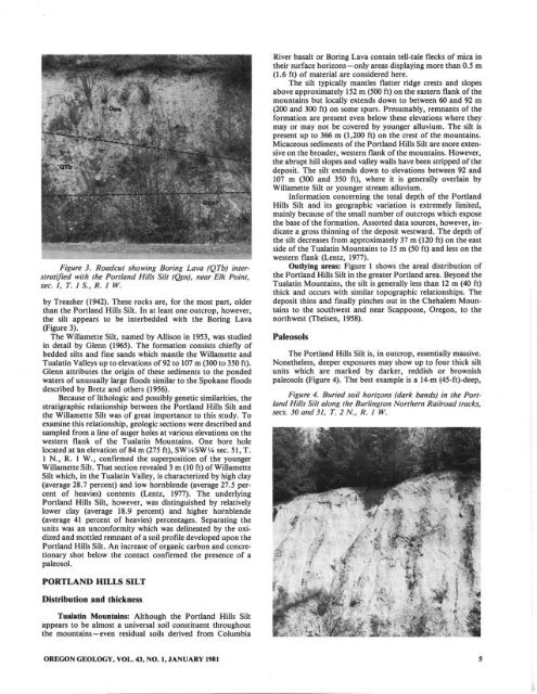
Figure 3. Roadcut showing Boring Lova (QTb) interstratified<br />
with <strong>the</strong> POril<strong>and</strong> <strong>Hills</strong> <strong>Silt</strong> (Qps), near Elk Point,<br />
st!C. I, T. IS., R. I W.<br />
by Treasher (1942). <strong>The</strong>se rocks are, for <strong>the</strong> most pan, older<br />
than <strong>the</strong> Portl<strong>and</strong> <strong>Hills</strong> <strong>Silt</strong>. In at least one outcrop, however,<br />
<strong>the</strong> silt appears to be interbedded with <strong>the</strong> Boring Lava<br />
(Figure 3).<br />
<strong>The</strong> Willamette <strong>Silt</strong>, named by Allison in 1953, was studied<br />
in detail by Glenn (1965). <strong>The</strong> formation consists chiefly <strong>of</strong><br />
bedded silts <strong>and</strong> fine s<strong>and</strong>s which mantle <strong>the</strong> Willamette <strong>and</strong><br />
Tualatin Valleys up 10 elevations <strong>of</strong>92 to 107 m (300 to 350 ft).<br />
Glenn attributes <strong>the</strong> origin <strong>of</strong> <strong>the</strong>se sediments to <strong>the</strong> ponded<br />
waters <strong>of</strong> unusually large floods similar to <strong>the</strong> Spokane floods<br />
described by Bretz <strong>and</strong> o<strong>the</strong>rs (1956).<br />
Because <strong>of</strong> lithologic <strong>and</strong> possibly genetic similarities, <strong>the</strong><br />
stratigraphic relationship betwccn <strong>the</strong> Portl<strong>and</strong> <strong>Hills</strong> <strong>Silt</strong> <strong>and</strong><br />
<strong>the</strong> WiliameUe <strong>Silt</strong> was <strong>of</strong> great importance to this study. To<br />
examine this relationship, geologic sections were described <strong>and</strong><br />
sampled from a line <strong>of</strong> auger holes at various elevations on <strong>the</strong><br />
western flank <strong>of</strong> <strong>the</strong> Tualatin Mountains. One bore hole<br />
located at1.n elevation <strong>of</strong>84 m (275 ft), SWV.SW v. sec. 51, T.<br />
I N., R. I W., confirmed <strong>the</strong> superposition <strong>of</strong> <strong>the</strong> younger<br />
Willamette <strong>Silt</strong>. That section revealed 3 m (10 ft) <strong>of</strong> Willamette<br />
<strong>Silt</strong> which, in <strong>the</strong> Tualatin Valley, is characterized by high clay<br />
(average 28.7 percent) <strong>and</strong> low hornblende (average 27.5 percent<br />
<strong>of</strong> heavies) contents (Lentz, 1977). <strong>The</strong> underlying<br />
Portl<strong>and</strong> <strong>Hills</strong> <strong>Silt</strong>, however, was distinguished by relatively<br />
lower clay (average 18.9 percent) <strong>and</strong> higher hornblende<br />
(average 41 percent <strong>of</strong> heavies) percentages. Separating <strong>the</strong><br />
units was an unconformity which was delineated by <strong>the</strong> oxidized<br />
<strong>and</strong> mottled remnant <strong>of</strong> a so il pr<strong>of</strong>ile developed upon <strong>the</strong><br />
Portl<strong>and</strong> <strong>Hills</strong> <strong>Silt</strong>. An increase <strong>of</strong> organic carbon <strong>and</strong> concretionary<br />
shot below <strong>the</strong> contact confirmed <strong>the</strong> presence <strong>of</strong> a<br />
paleosol.<br />
River basalt or Boring Lava contain tell-tale flecks <strong>of</strong> mica in<br />
<strong>the</strong>ir surface horizons-only areas displaying more than 0.5 m<br />
(1.6 ft) <strong>of</strong> material arc considered here.<br />
<strong>The</strong> silt typically mantles flatter ridge crests <strong>and</strong> slopes<br />
above approximately 152 m (500 ft) on <strong>the</strong> eastern flank <strong>of</strong> <strong>the</strong><br />
mountains but locally extends down to between 60 <strong>and</strong> 92 m<br />
(200 <strong>and</strong> 300 ft) on some spurs. Presumably, remnants <strong>of</strong> <strong>the</strong><br />
formation arc present even below <strong>the</strong>se elevations where <strong>the</strong>y<br />
mayor may not be covered by younger allu vium. <strong>The</strong> silt is<br />
present up to 366 m (1,200 ft) on <strong>the</strong> crest <strong>of</strong> <strong>the</strong> mountains.<br />
Micaceous sediments <strong>of</strong> <strong>the</strong> Portl<strong>and</strong> <strong>Hills</strong> <strong>Silt</strong> are more extensive<br />
on <strong>the</strong> broader, western flank <strong>of</strong> <strong>the</strong> mountains. However,<br />
<strong>the</strong> abrupt hill slopes <strong>and</strong> valley walls have ~n stripped <strong>of</strong> <strong>the</strong><br />
deposit. <strong>The</strong> silt extends down to elevations betwccn 92 <strong>and</strong><br />
107 m (300 <strong>and</strong> 350 ft), where it is generally overlain by<br />
Wiltamette <strong>Silt</strong> or younger stream alluvium.<br />
Information concerning <strong>the</strong> total depth <strong>of</strong> <strong>the</strong> Portl<strong>and</strong><br />
<strong>Hills</strong> <strong>Silt</strong> <strong>and</strong> its geographic variation is extremely limited,<br />
mainly because <strong>of</strong> <strong>the</strong> small number <strong>of</strong> outcrops which expose<br />
<strong>the</strong> base <strong>of</strong> <strong>the</strong> formation. Assorted data sources, however, indicate<br />
a gross thinning <strong>of</strong> <strong>the</strong> deposit westward. <strong>The</strong> depth <strong>of</strong><br />
<strong>the</strong> silt decreases from approximately 37 m (120 ft) on <strong>the</strong> east<br />
side <strong>of</strong> <strong>the</strong> Tualatin Mountains to 15m (50 ft) <strong>and</strong> less on <strong>the</strong><br />
western flank (lentz, 1977).<br />
Outlying arus: Figure I shows <strong>the</strong> areal distribution <strong>of</strong><br />
<strong>the</strong> Ponl<strong>and</strong> <strong>Hills</strong> <strong>Silt</strong> in <strong>the</strong> greater Portl<strong>and</strong> area. Beyond <strong>the</strong><br />
Tualatin Mountains, <strong>the</strong> silt is generally less than 12 m (40 ft)<br />
thick <strong>and</strong> occurs with similar topographic relationships. <strong>The</strong><br />
deposit thins <strong>and</strong> finally pinches out in <strong>the</strong> Chehalem Mountains<br />
to <strong>the</strong> southwest <strong>and</strong> near Scappoose, <strong>Oregon</strong>, to <strong>the</strong><br />
northwest (<strong>The</strong>isen, 1958).<br />
Paleosols<br />
<strong>The</strong> Portl<strong>and</strong> <strong>Hills</strong> <strong>Silt</strong> is, in outcrop, essentially massive.<br />
None<strong>the</strong>less, dccper exposures may show up to four thick silt<br />
units which arc marked by darker, reddish or brownish<br />
paleosols (Figure 4). <strong>The</strong> best example is a 14-m (45-ft)-dccp,<br />
Figure 4. Buried soil horiz;ons (dark bonds) in <strong>the</strong> POril<strong>and</strong><br />
<strong>Hills</strong> Sill along <strong>the</strong> Burlington Nor<strong>the</strong>rn Railroad tracks,<br />
sees. 30 <strong>and</strong> 31, T. 2 N., R. / W.<br />
PORTLAND HILLS SILT<br />
Dislribution <strong>and</strong> Ihickness<br />
Tualalin Mountains: Although <strong>the</strong> Portl<strong>and</strong> <strong>Hills</strong> <strong>Silt</strong><br />
appears to be almost a universal soil constituent throughout<br />
<strong>the</strong> mountains-even residual soils derived from Columbia<br />
OREGON GEOLOGY, VOL. 43, NO. I, JANUARY 1981<br />
,


