

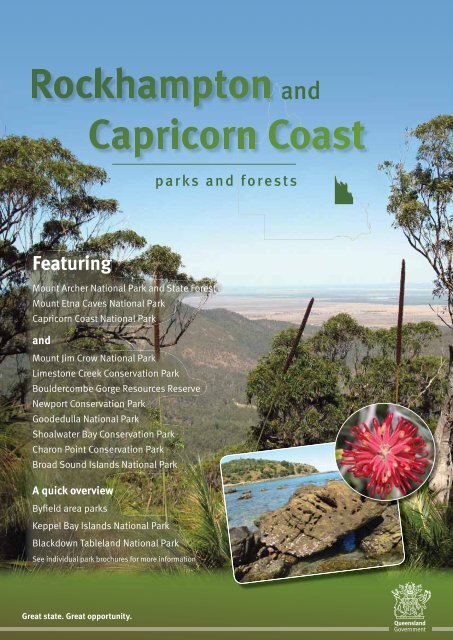
Rockhampton and Capricorn Coast parks and forests visitor guide
Rockhampton and Capricorn Coast parks and forests visitor guide
Rockhampton and Capricorn Coast parks and forests visitor guide

You also want an ePaper? Increase the reach of your titles
YUMPU automatically turns print PDFs into web optimized ePapers that Google loves.
<strong>and</strong><br />
<strong>parks</strong> <strong>and</strong> <strong>forests</strong><br />
Featuring<br />
Mount Archer National Park <strong>and</strong> State Forest<br />
Mount Etna Caves National Park<br />
<strong>Capricorn</strong> <strong>Coast</strong> National Park<br />
<strong>and</strong><br />
Mount Jim Crow National Park<br />
Limestone Creek Conservation Park<br />
Bouldercombe Gorge Resources Reserve<br />
Newport Conservation Park<br />
Goodedulla National Park<br />
Shoalwater Bay Conservation Park<br />
Charon Point Conservation Park<br />
Broad Sound Isl<strong>and</strong>s National Park<br />
A quick overview<br />
Byfield area <strong>parks</strong><br />
Keppel Bay Isl<strong>and</strong>s National Park<br />
Blackdown Tablel<strong>and</strong> National Park<br />
See individual park brochures for more information<br />
Great state. Great opportunity.
Photo: John Augusteyn, NPRSR<br />
Welcome to<br />
From decorated limestone caves to<br />
rainforest-edged creeks, heath-clad<br />
hills <strong>and</strong> the isl<strong>and</strong>-studded Keppel<br />
Bay, the <strong>parks</strong> <strong>and</strong> <strong>forests</strong> surrounding<br />
<strong>Rockhampton</strong> have it all. Enjoy a picnic in<br />
a cool rainforest, hike down a mountain,<br />
relax on a secluded beach, or choose<br />
your own adventure in one, or all, of<br />
these special places.<br />
The <strong>parks</strong> <strong>and</strong> <strong>forests</strong> surrounding<br />
<strong>Rockhampton</strong> protect many nearthreatened<br />
<strong>and</strong> endangered plants<br />
<strong>and</strong> animals, some of which are found<br />
nowhere else. Many <strong>parks</strong> in the region<br />
have links to our prehistoric past—<br />
fossilised reef remains, ancient<br />
cycads <strong>and</strong> dry rain<strong>forests</strong>, a relict<br />
of wetter times.<br />
Dry rainforest <strong>and</strong><br />
limestone karst<br />
Indigenous links<br />
The region surrounding <strong>Rockhampton</strong><br />
forms part of the Darumbal Aboriginal<br />
people’s traditional country. There are<br />
many sites important to the Darumbal<br />
people throughout the area, including<br />
Mounts Wheeler <strong>and</strong> Jim Crow.<br />
A Dreaming legend tells how the rainbow<br />
serpent created Mount Jim Crow.<br />
The Keppel isl<strong>and</strong>s are the Woppaburra<br />
Aboriginal people’s traditional home.<br />
Their ancestors lived on some Keppel<br />
isl<strong>and</strong>s for at least 4000 years, using<br />
the rich resources of the sea, reef<br />
<strong>and</strong> intertidal zones to support their<br />
community lifestyle. In 1902, the last<br />
of the Woppaburra people were forcibly<br />
removed from the Keppels <strong>and</strong> sent to<br />
Aboriginal missions. Today descendants<br />
are re-establishing cultural ties to their<br />
traditional homel<strong>and</strong>, fulfilling cultural<br />
obligations to ‘care for country’ <strong>and</strong><br />
passing this inheritance on to<br />
their children.<br />
Experience Mount Etna’s limestone<br />
along the Cammoo walking track.<br />
In contrast, walk Bluff Point’s<br />
volcanic headl<strong>and</strong> for great views.<br />
Photo:<br />
Mike K orotco o<br />
ff,<br />
f,<br />
NPRSR<br />
Photo: Kim Walters, NPRSR<br />
Photo: NPRSR<br />
2<br />
Photo: Querida Hutchinson, NPRSR
Photo: John Augusteyn, NPRSR<br />
Mother bent-wing bats return to the nursery cave to<br />
feed their young. They must find their own pup amidst<br />
thous<strong>and</strong>s of babies squashed together for warmth<br />
Take a walk<br />
on the wild side<br />
Keep your eye out for some iconic<br />
Australians while exploring<br />
<strong>Rockhampton</strong>’s <strong>parks</strong> <strong>and</strong> <strong>forests</strong>.<br />
From majestic wedge-tailed eagles<br />
soaring overhead to the tiny bent-wing<br />
bats inhabiting Mount Etna Caves<br />
National Park, <strong>Rockhampton</strong>’s wildlife<br />
may surprise you.<br />
Byfield fern<br />
Photo: John Augusteyn, NPRSR<br />
Photo: Rhonda Melzer<br />
The region is lucky to share its rivers<br />
with a link to its prehistoric past—<br />
crocodiles.<br />
Both estuarine <strong>and</strong> freshwater crocodiles<br />
live in the region’s rivers <strong>and</strong>, regardless<br />
of their names, both can live in fresh <strong>and</strong><br />
salt water sections. Despite surviving<br />
since the days of dinosaurs, today<br />
estuarine crocodiles are vulnerable to<br />
extinction <strong>and</strong> are protected. Keep a<br />
lookout—you just might see one of these<br />
ancient animals. Always be croc-wise <strong>and</strong><br />
never swim where crocodiles may live.<br />
See ‘Staying safe’ for further information.<br />
<strong>Rockhampton</strong>’s ghost <strong>and</strong> little<br />
bent-wing bats were once the focus<br />
of Australia’s longest running<br />
conservation battle.<br />
Mount Etna Caves National Park now<br />
protects the habitat of these vulnerable<br />
bats. You can see little bent-wing<br />
bats on an evening tour to Bat Cleft<br />
during summer. Be awed as you watch<br />
thous<strong>and</strong>s of bats emerge from their<br />
daytime roost to feed on insects,<br />
small birds <strong>and</strong> mammals. For further<br />
information about Mount Etna Caves<br />
National Park <strong>and</strong> its tours to Bat Cleft,<br />
visit . Leave pets<br />
at home<br />
Leave pets at home<br />
Domestic animals, particularly dogs <strong>and</strong><br />
cats, are not permitted in national <strong>parks</strong>,<br />
on some beaches adjacent to mainl<strong>and</strong><br />
national <strong>parks</strong>, or any beach adjacent<br />
to national park isl<strong>and</strong>s. National <strong>parks</strong><br />
protect our natural heritage <strong>and</strong> are<br />
wildlife refuges. Pets can harass wildlife,<br />
<strong>and</strong> could be injured in the process.<br />
Look for ancient cycads, like zamia<br />
palms on the Mount Archer’s Zamia walk.<br />
The Byfield fern, with glossy dark green<br />
fernlike foliage, is also a cycad.<br />
Some <strong>parks</strong> are also very remote <strong>and</strong><br />
wild. Pets can be easily lost in such<br />
places. Leave them where they’ll stay<br />
safe—either at home, with friends or in<br />
a professional kennel while you explore<br />
our national <strong>parks</strong>.<br />
Bringing domestic animals into a national<br />
park is an offence <strong>and</strong> penalties apply.<br />
Photo: John Augusteyn, NPRSR<br />
Estuarine crocodile<br />
3
4<br />
<strong>Rockhampton</strong> <strong>and</strong> <strong>Capricorn</strong> <strong>Coast</strong><br />
<strong>parks</strong> <strong>and</strong> <strong>forests</strong>
Photo: John Augusteyn, NPRSR<br />
Moores Creek from the Zamia track, Mount Archer<br />
Zamia walking track at Mount Archer<br />
Day trip<br />
adventures<br />
There are numerous <strong>parks</strong> <strong>and</strong> <strong>forests</strong> in<br />
the <strong>Rockhampton</strong> area for you to explore<br />
on a day out. Have a picnic, go for a<br />
bushwalk or be delighted by the many<br />
opportunities for wildlife watching these<br />
<strong>parks</strong> <strong>and</strong> <strong>forests</strong> have to offer.<br />
Mount Archer National Park<br />
<strong>and</strong> State Forest<br />
Overlooking the bustling city, Mount<br />
Archer is the Berserker Range’s tallest<br />
peak <strong>and</strong> offers a cool respite from the<br />
<strong>Rockhampton</strong> heat. Rising to 604 m<br />
above sea level, the summit boasts<br />
views of <strong>Rockhampton</strong> <strong>and</strong> the Fitzroy<br />
River to the west, <strong>and</strong> east to the ocean<br />
on a clear day.<br />
Mount Archer National Park protects<br />
4250 ha of open forest <strong>and</strong> woodl<strong>and</strong><br />
communities dominated by eucalypts,<br />
with a large pocket of dry rainforest<br />
in the deeply incised Moores Creek<br />
valley. The park’s dry rainforest<br />
has high conservation value <strong>and</strong><br />
includes several plant species<br />
with restricted distributions.<br />
Mount Archer State Forest<br />
adjoins the national park<br />
<strong>and</strong> is a haven for wildlife.<br />
Fossicking is not permitted<br />
in either the state forest or<br />
the national park.<br />
Access<br />
Access the national park via the<br />
scenic Pilbeam Drive. This steep <strong>and</strong><br />
winding sealed 5 km drive is suitable<br />
for conventional vehicles <strong>and</strong> features<br />
lookouts with easy roadside access.<br />
The park’s lower entrance is off Sunset<br />
Drive—signs will direct you there. There<br />
is no designated car park <strong>and</strong> it is<br />
recommended not to commence the<br />
steep Zamia Walk from this entrance.<br />
Things to do<br />
<strong>Rockhampton</strong> Regional Council manages<br />
<strong>and</strong> maintains Fraser Park, the picnic<br />
area at Mount Archer’s summit. Picnic<br />
tables, barbecues, drinking water <strong>and</strong><br />
wheelchair-accessible toilets<br />
are available. Pets are<br />
permitted in Fraser Park<br />
but are prohibited in the<br />
adjacent national park.<br />
Photo: Matt Kayes<br />
Bruce Highway<br />
QPWS<br />
office<br />
Moores<br />
Photo: Kylie Harris, NPRSR<br />
Norman Rd<br />
Creek Rd<br />
Dean St<br />
Yeppoon Rd<br />
German<br />
St<br />
To <strong>Rockhampton</strong><br />
Scale<br />
0 2 km<br />
Walking<br />
Four walks entice <strong>visitor</strong>s to explore<br />
Mount Archer. Explore the summit on two<br />
short walks within the council-managed<br />
Fraser Park, starting from the picnic area.<br />
For a bigger challenge, you can hike down<br />
the mountain within the national park via<br />
the Zamia Walk.<br />
Walking track circuit—500 m circuit<br />
(allow 20 mins) Grade: easy,<br />
wheelchair accessible<br />
Enjoy spectacular views from two<br />
lookouts. From one you can look west<br />
over <strong>Rockhampton</strong> <strong>and</strong> the Fitzroy River<br />
<strong>and</strong> from the other you can look east as<br />
far as the coast. The track starts near<br />
the toilets.<br />
Bracken Fern Way—1.4 km return<br />
(allow 45 mins) Grade: easy<br />
From the lower end of the picnic area,<br />
you can walk to Grasstree Lookout to<br />
see the three peaks of Mounts Badger,<br />
Sleipner <strong>and</strong> Berserker.<br />
Sleipner Lookout Walk—2.4 km return<br />
(allow 1 hr) Grade: moderate<br />
Enjoy the first section of the Zamia Walk<br />
to Sleipner Lookout to see the distinct<br />
pointy peak of Mount Sleipner <strong>and</strong> its<br />
spectacular surrounds. The return walk<br />
is uphill <strong>and</strong> can be challenging.<br />
Zamia Walk—14 km one-way<br />
(allow up to 5 hrs) Grade: difficult<br />
The full Zamia Walk is a long descent<br />
from the top of Mount Archer, through<br />
the national park to the park’s lower<br />
entrance. It is best to walk this track from<br />
top to bottom <strong>and</strong> arrange to be picked<br />
up at the lower exit at German Street.<br />
Frenchville Rd<br />
Zamia<br />
Walk<br />
To Yeppoon<br />
Pilbeam Dr<br />
<strong>Rockhampton</strong>-Emu<br />
Park Rd<br />
Moores Creek<br />
Mount Archer<br />
State Forest<br />
Mount Archer<br />
National Park<br />
To Emu Park<br />
Fringed lily<br />
5
Mount Etna Caves<br />
National Park<br />
Once submerged by a shallow sea, water<br />
has continued to shape this park. About<br />
390 million years ago, limestone from<br />
ancient coral reefs fossilised fish <strong>and</strong><br />
invertebrate remains before the sea<br />
dried up. Trickling water eroded the dry<br />
seabed to create cracks, crevices <strong>and</strong> a<br />
lunarscape of limestone karsts.<br />
Photo: Kim Walters, NPRSR<br />
As Mount Etna’s l<strong>and</strong>scape has<br />
evolved, so too have people’s attitudes<br />
towards the mountain. Once the focus<br />
of Australia’s longest conservation<br />
dispute, Mount Etna Caves National<br />
Park now protects the mountain for<br />
future generations.<br />
The park’s network of limestone caves<br />
are a vital nursery for little bent-wing<br />
bats <strong>and</strong> one of the few areas in<br />
Australia where vulnerable ghost bats<br />
live <strong>and</strong> breed.<br />
Access<br />
Head north from <strong>Rockhampton</strong> to The<br />
Caves township <strong>and</strong> turn right, crossing<br />
the train tracks. Follow the road <strong>and</strong> turn<br />
right onto Barmoya Road. Keep heading<br />
east <strong>and</strong> turn left into Cammoo Caves<br />
Road, which will take you to the picnic<br />
area. To access Bat Cleft, head north<br />
from The Caves along Rossmoya Road<br />
for 2 km, turn left at the road side marker<br />
<strong>and</strong> leave your vehicle in the car park at<br />
the start of the walking track.<br />
Mt Etna<br />
Mt Etna Caves<br />
National Park<br />
Things to do<br />
Have a picnic <strong>and</strong> explore the park’s<br />
stories at the Cammoo Caves picnic area.<br />
An informative shelter <strong>and</strong> self-<strong>guide</strong>d<br />
walking trail will help you discover more<br />
about the park’s unique bats, conflictfilled<br />
past <strong>and</strong> remnant dry rainforest.<br />
Guided tours<br />
Self-<strong>guide</strong>d walk at Cammoo<br />
Bat Cleft tours at Mount Etna<br />
Experience the rush of thous<strong>and</strong>s of tiny<br />
bats flashing past you at dusk during a<br />
ranger-<strong>guide</strong>d tour. Tours are run from<br />
December until mid-February each year.<br />
Little bent-wing bats fly out from their<br />
roost in Bat Cleft to feed, providing a<br />
spectacular natural show. Contact the<br />
Queensl<strong>and</strong> Parks <strong>and</strong> Wildlife Service<br />
(QPWS) <strong>Rockhampton</strong> office to book<br />
your tour.<br />
Picnic area at Cammoo<br />
Walking<br />
Two walking tracks offer<br />
different experiences in the<br />
park. Choose the one that most<br />
suits your interests <strong>and</strong> abilities.<br />
Photo: Kim Walters, NPRSR<br />
Cammoo circuit—600 m circuit<br />
(allow 45 mins) Grade: easy<br />
W<strong>and</strong>er along a self-<strong>guide</strong>d walk through<br />
remnant dry rainforest clinging to<br />
limestone karst <strong>and</strong> uncover the secrets<br />
this fragile ecosystem holds. Read about<br />
the bitter battle between limestone<br />
miners <strong>and</strong> conservationists <strong>and</strong> how<br />
the dispute was finally resolved.<br />
Photo: John Augusteyn, NPRSR<br />
To Mackay<br />
Scale<br />
0<br />
6<br />
500 m<br />
Rossmoya Rd<br />
Bruce Highway<br />
To <strong>Rockhampton</strong><br />
Limestone Ridge<br />
Barmoya Rd<br />
Cl<br />
Spring Creek<br />
Cammoo<br />
picnic area<br />
Cammoo<br />
Caves Rd<br />
The Caves township<br />
Banksia<br />
Photo: Matt Kayes<br />
Bat Cleft track—2.4 km return<br />
(allow 1 hr) Grade: moderate<br />
Expansive views of Limestone Ridge, the<br />
historic Pilkington Quarry <strong>and</strong> old mine<br />
workings feature strongly on this walk.<br />
The 1.2 km track uphill to Bat Cleft is<br />
quite strenuous with many steps. Walk<br />
in the cooler months or early morning<br />
to avoid the heat. Only relatively fit<br />
people should attempt this walk or join<br />
a Bat Cleft tour. Guided tours operate<br />
during the bats’ breeding season. From<br />
1 November to the end of February each<br />
year you may access this track via <strong>guide</strong>d<br />
tour only.
Photo: Kim Walters, NPRSR<br />
Photo: Querida Hutchinson, NPRSR<br />
Fan Rock at Double Head<br />
Coral <strong>and</strong> pebbles at<br />
North Keppel Isl<strong>and</strong><br />
Callistemon<br />
Photo: NPRSR<br />
Looking towards Bluff Point from Kemp Beach<br />
Photo: Andrew McDougall, NPRSR<br />
Walking<br />
Circuit track—2.3 km circuit<br />
(allow 1.5 hrs) Grade: moderate<br />
Enjoy panoramic views of the <strong>Capricorn</strong><br />
coastline <strong>and</strong> the Keppel Bay isl<strong>and</strong>s<br />
on this circuit. The circuit offers views<br />
of trachyte rock formations <strong>and</strong> the<br />
northern coastline. Foraging turtles<br />
<strong>and</strong> dolphins can often be seen in<br />
the waters below.<br />
<strong>Capricorn</strong> <strong>Coast</strong> National Park<br />
Near the coastal town of Yeppoon,<br />
<strong>Capricorn</strong> <strong>Coast</strong> National Park protects<br />
six reserves totalling 113 ha. Windswept<br />
heath scattered with p<strong>and</strong>anus <strong>and</strong> sheoaks,<br />
open eucalypt forest, vine thickets,<br />
tussock grassl<strong>and</strong> <strong>and</strong> mangroves feature<br />
strongly here.<br />
Rocky outcrops are a prominent feature<br />
of the <strong>Capricorn</strong> <strong>Coast</strong>. Lava forced<br />
through outer layers of rock created these<br />
trachyte plugs in the late Cretaceous era,<br />
about 73 million years ago. Erosion has<br />
worn away the outer layers leaving the<br />
hard resistant rock as rugged peaks.<br />
Access<br />
<strong>Capricorn</strong> <strong>Coast</strong> National Park has three<br />
sections with formalised public access:<br />
the Double Head <strong>and</strong> Bluff Point sections<br />
near Rosslyn Bay Harbour <strong>and</strong> the most<br />
southerly section, Cocoanut Point<br />
near Zilzie.<br />
There is no formal access to the Vallis<br />
Park, Pinnacle Point or Rosslyn Head<br />
sections of <strong>Capricorn</strong> <strong>Coast</strong><br />
National Park.<br />
Double Head section<br />
This section adjoins Rosslyn Bay Harbour<br />
<strong>and</strong> is accessed from John Howes Drive<br />
via the Scenic Highway from Yeppoon.<br />
Featuring vine thicket with overhanging<br />
fig trees, windswept <strong>and</strong> stunted<br />
scrubl<strong>and</strong> <strong>and</strong> open tussock grassl<strong>and</strong><br />
with grasstrees.<br />
Walking<br />
Lookout track—365 m one-way<br />
(allow 40 mins) Grade: moderate<br />
Follow a 365 m track to two lookouts.<br />
The first overlooks Fan Rock, with its<br />
intriguing rock fractured into hexagonal<br />
columns. The second lookout gives a<br />
bird’s eye view of the harbour.<br />
Bluff Point section<br />
Follow the Scenic Highway south<br />
from Yeppoon to access Bluff Point<br />
at the southern end of Kemp Beach.<br />
This popular picnic spot has superb<br />
coastal scenery. It features a range of<br />
coastal vegetation from mangroves <strong>and</strong><br />
heath-l<strong>and</strong>s to stunted open eucalypt<br />
<strong>forests</strong> <strong>and</strong> tussock grassl<strong>and</strong>s.<br />
Barbecues <strong>and</strong> toilets are provided<br />
among shady s<strong>and</strong>paper figs, narrowleaved<br />
ironbarks <strong>and</strong> quinine trees.<br />
Cocoanut Point section<br />
The Cocoanut Point section has<br />
pedestrian access via Reef Street,<br />
Hideaway Road, Brahminy Place or<br />
Coral Isl<strong>and</strong>s Court at Zilzie. Walking<br />
tracks traverse vine thickets with a<br />
heath understorey in this small section.<br />
There is no formal access to the<br />
headl<strong>and</strong> <strong>and</strong> dogs are not permitted.<br />
To Byfield<br />
Vallis Park<br />
Yeppoon Road<br />
To <strong>Rockhampton</strong><br />
Yeppoon<br />
Scenic Highway<br />
Tanby Road<br />
To <strong>Rockhampton</strong><br />
Double Head<br />
Scale<br />
0 2 4 km<br />
Rosslyn Head<br />
Bluff Point<br />
Pinnacle Point<br />
Emu Park<br />
Cocoanut Point<br />
Photo: Lisa Scott<br />
View from Bluff Point north to Double Head<br />
7
Photos: Andrew McDougall, NPRSR<br />
See Limestone Creek at the northern<br />
border of the park<br />
Carpet python<br />
Photo: NPRSR<br />
Limestone Creek<br />
Conservation Park<br />
On <strong>Rockhampton</strong>’s northern outskirts<br />
lies the little-known Limestone Creek<br />
Conservation Park. Featuring a network<br />
of walking tracks through open eucalypt<br />
woodl<strong>and</strong>, this park offers a quiet respite<br />
from the noisy city. A great location for<br />
morning <strong>and</strong> afternoon walks, all tracks<br />
are level <strong>and</strong> an easy grade, so get a<br />
group together <strong>and</strong> explore. Dogs are not<br />
permitted in this park, so remember to<br />
leave them at home.<br />
Access<br />
Limestone Creek Conservation Park lies<br />
on the corner of Norman <strong>and</strong> Yeppoon<br />
roads in North <strong>Rockhampton</strong>. Park your<br />
car at the QPWS office <strong>visitor</strong> car park <strong>and</strong><br />
access the park’s walking tracks via the<br />
turnstile to the west of the office.<br />
Newport Conservation Park<br />
Historic relics of past boating eras,<br />
including an old loading ramp <strong>and</strong><br />
railway line, litter this park. Newport<br />
Conservation Park shares a boundary<br />
with Meatworks Creek, protecting salt<br />
pans <strong>and</strong> associated vegetation. The park<br />
floods during king tides. Access Newport<br />
Conservation Park via St Lawrence.<br />
Settlement Road will lead you straight to<br />
the park. Camping is not permitted.<br />
Mount Jim Crow National Park<br />
This conspicuous mountain is 29 km<br />
north-east of <strong>Rockhampton</strong> on Yeppoon<br />
Road, <strong>and</strong> rises 221 m above sea level.<br />
Volcanic activity created the trachyte<br />
plug known as Mount Jim Crow. This<br />
impressive dome’s base <strong>and</strong> lower<br />
slopes are covered in semi-evergreen<br />
vine thickets <strong>and</strong> hoop pines tower<br />
over the dry rainforest. No facilities are<br />
provided <strong>and</strong> camping is not permitted.<br />
Access<br />
The car park at Mount Jim Crow National<br />
Park is easily visible as you travel east<br />
along Yeppoon Road. There is a small<br />
walking track leading to a former quarry,<br />
but there is no walking track to the<br />
mountain’s summit. Scrambling up the<br />
mountain’s rocky scree slopes <strong>and</strong> cliffs<br />
is dangerous <strong>and</strong> not recommended.<br />
Bouldercombe Gorge<br />
Resources Reserve<br />
Encompassing the steep <strong>and</strong> spectacular<br />
gorges of the Gavial <strong>and</strong> Plumtree creek<br />
headwaters, three sections protect this<br />
scenic reserve. Partly hidden in the<br />
ranges between <strong>Rockhampton</strong> <strong>and</strong> Mount<br />
Morgan, the reserve rises sharply from<br />
the floodplain <strong>and</strong> provides magnificent<br />
views for those prepared to challenge<br />
the slopes. After good rain, a system of<br />
creeks, waterfalls <strong>and</strong> waterholes are<br />
present, providing a welcome refuge<br />
for wildlife.<br />
Access<br />
The reserve is 20 km south of<br />
<strong>Rockhampton</strong>, however only the north<br />
<strong>and</strong> middle sections are accessible.<br />
The north section is accessible via<br />
Mount Usher Road; the middle section<br />
via Struck Oil Road. Only the north<br />
section has a formal walking track.<br />
Walking<br />
Follow the north section’s walking track<br />
to discover Bouldercombe Gorge Falls.<br />
These falls are seasonal <strong>and</strong> only flow<br />
after plentiful rain. Take extra care during<br />
heavy rain or thunderstorms as flash<br />
flooding can occur. The walk from the<br />
car park to the falls is rough <strong>and</strong> poorly<br />
defined in many places. It takes about<br />
1.5 hours return. Never attempt to cross<br />
flooded creeks. Allow extra time to<br />
explore. The national Bicentennial Trail<br />
traverses the reserve’s north section<br />
<strong>and</strong> is accessed via Dee Road.<br />
To <strong>Rockhampton</strong><br />
Bouldercombe<br />
Mount Morgan<br />
Northern<br />
section<br />
Middle<br />
section<br />
Southern<br />
section<br />
8<br />
Scale<br />
0 4 8 km
Overnight<br />
adventures<br />
Many more <strong>parks</strong> <strong>and</strong> <strong>forests</strong> are waiting<br />
to be explored <strong>and</strong> offer rewarding<br />
experiences if you are prepared to camp.<br />
Some are accessible by conventional<br />
vehicle, others by four-wheel drive only,<br />
<strong>and</strong> some only by boat. Each offers a<br />
different adventure. For those <strong>parks</strong><br />
on the coast, remember to bring insect<br />
repellent as mosquitoes <strong>and</strong> s<strong>and</strong>flies<br />
can be prolific.<br />
Grass tree at Goodedulla National Park<br />
Rainbow bee eater<br />
Charon Point<br />
Conservation Park<br />
Photo: John Augusteyn, NPRSR<br />
Photo: John Augusteyn, NPRSR<br />
Goodedulla National Park<br />
Meaning ‘eagle flying overhead’ in the<br />
Darumbal language, Goodedulla is<br />
home to many threatened species. The<br />
scenic Melaleuca Creek flows through<br />
this remote park <strong>and</strong> birdwatching is<br />
particularly good with more than 80 bird<br />
species recorded here. Take care as the<br />
park’s road network can be confusing.<br />
You must be self-sufficient. Heavy rain<br />
can flood the seasonal creek, potentially<br />
str<strong>and</strong>ing <strong>visitor</strong>s, so be well-prepared.<br />
Camping is available at Wadlow Yards,<br />
Kings Dam <strong>and</strong> The Palms. No facilities<br />
are provided. A detailed park map is<br />
available at .<br />
Access<br />
Goodedulla National Park is<br />
approximately 50 km north of Gogango<br />
<strong>and</strong> accessible via four-wheel drive<br />
only. Turn off the <strong>Capricorn</strong> Highway at<br />
Gogango <strong>and</strong> follow the signs north to<br />
Rookwood Station. Do not turn towards<br />
the house but follow the park signs<br />
<strong>and</strong> keep heading north. The track is<br />
rough, unsealed <strong>and</strong> goes through<br />
private property. It can take more than<br />
45 minutes to travel the final 10 km<br />
to the park. Leave all gates as you<br />
find them.<br />
Just 30 km north of Marlborough lies<br />
Charon Point Conservation Park. Camp<br />
at the mouth of the Styx River, famous<br />
for its huge tides <strong>and</strong> fast flows. Fishing<br />
<strong>and</strong> crabbing are popular activities<br />
here. Access the park by heading into<br />
Marlborough <strong>and</strong> turning left up Bald<br />
Hills Road. Follow this road to the point.<br />
The access road travels through private<br />
property so please leave gates as you<br />
find them. Camping is limited to a<br />
maximum of four nights per person per<br />
month. See ‘Camping in protected areas’<br />
in this <strong>guide</strong> for more information about<br />
how to obtain a permit.<br />
Goodedulla<br />
National Park<br />
20 Mile Hut<br />
Rookwood Station<br />
Gogango<br />
Duaringa<br />
To <strong>Rockhampton</strong><br />
Scale<br />
0 20 km<br />
Camping<br />
Camping in the <strong>parks</strong> <strong>and</strong> <strong>forests</strong><br />
surrounding <strong>Rockhampton</strong> can be an<br />
enjoyable <strong>and</strong> rewarding experience.<br />
Please help it stay that way by<br />
following the <strong>guide</strong>lines below.<br />
• Obtain your camping permit before<br />
setting up camp. Camp sites can<br />
be booked online at , by calling 13 QGOV<br />
(13 74 68), or in person at local<br />
<strong>visitor</strong> information centres or the<br />
Byfield General Store.<br />
• Camp only in designated areas.<br />
Take care not to damage the plants<br />
around your camp site. Tying ropes<br />
to trees is not permitted.<br />
• Do not contaminate watercourses<br />
with detergent, toothpaste or<br />
soap. Take water for cleaning<br />
or washing at least 50 m away<br />
from watercourses. Always use<br />
biodegradable cleaning products.<br />
• Keep your camping gear pest-free.<br />
Check your clothes, shoes <strong>and</strong><br />
gear for pests such as seeds,<br />
insects or rodents. Help prevent<br />
pest introductions <strong>and</strong> halt<br />
their spread.<br />
Photo: NPRSR<br />
Boat ramp at Charon Point Conservation Park<br />
9
Shoalwater Bay<br />
Photo: John Augusteyn, NPRSR<br />
Shoalwater Bay<br />
Conservation Park<br />
Accessible only by boat, this coastal<br />
park is just north of the Shoalwater<br />
Bay Training Area <strong>and</strong> offers secluded<br />
camping with no facilities. Dogs are<br />
not permitted.<br />
Keppel Bay Isl<strong>and</strong>s<br />
National Park<br />
Keppel Bay is a broad sweep of water off<br />
the Central Queensl<strong>and</strong> coast, from Curtis<br />
Isl<strong>and</strong> to Corio Bay. The picturesque<br />
<strong>Capricorn</strong> <strong>Coast</strong> with its townships of<br />
Yeppoon, Emu Park <strong>and</strong> Keppel S<strong>and</strong>s<br />
fronts Keppel Bay.<br />
The bay is studded with isl<strong>and</strong>s, featuring<br />
steep hills <strong>and</strong> cliffs which plunge into<br />
the sea, but there are also sheltered<br />
bays <strong>and</strong> quiet s<strong>and</strong>y beaches.<br />
Vegetation ranges from open grassl<strong>and</strong><br />
<strong>and</strong> heath-l<strong>and</strong> to tall shady <strong>forests</strong> <strong>and</strong><br />
dense low rain<strong>forests</strong>.<br />
Fifteen of the Keppel group of isl<strong>and</strong>s<br />
make up Keppel Bay Isl<strong>and</strong>s National<br />
Park, <strong>and</strong> are surrounded by the Great<br />
Barrier Reef Marine Park. Together they<br />
form part of the Great Barrier Reef World<br />
Heritage Area.<br />
North Keppel <strong>and</strong> Humpy isl<strong>and</strong>s have<br />
walking tracks, on-site information<br />
<strong>and</strong> day-use <strong>and</strong> camping<br />
facilities. Some other isl<strong>and</strong>s<br />
allow for camping.<br />
For more information see<br />
details on page 12, or pick<br />
up a copy of the Keppel<br />
Bay Isl<strong>and</strong>s National Park<br />
<strong>visitor</strong> <strong>guide</strong>.<br />
Broad Sound<br />
Isl<strong>and</strong>s National Park<br />
Visitor <strong>guide</strong><br />
Protecting our lifestyle <strong>and</strong> environment<br />
Queensl<strong>and</strong> Parks <strong>and</strong> Wildlife Service<br />
Department of Environment <strong>and</strong> Resource Management<br />
Broad Sound Isl<strong>and</strong>s National Park is<br />
the most diverse <strong>and</strong> remote range of<br />
continental isl<strong>and</strong>s in the Great Barrier<br />
Reef World Heritage Area. It includes 48<br />
isl<strong>and</strong>s <strong>and</strong> extends 130 km eastward<br />
from the Sarina–Clairview coast. Broad<br />
Sound <strong>and</strong> Shoalwater Bay are the<br />
largest macrotidal bays on Australia’s<br />
east coast.<br />
Small group camping (maximum six<br />
campers) with no facilities is permitted<br />
on High Peak, Flock Pigeon, Aquila,<br />
Hexham <strong>and</strong> Shields isl<strong>and</strong>s.<br />
Access the isl<strong>and</strong>s by boat from the small<br />
townships of Stanage Bay <strong>and</strong> Clairview.<br />
The navigation aid book Cruising<br />
the Curtis <strong>Coast</strong> by Noel Patrick is an<br />
essential on-board companion.<br />
Many of the national park isl<strong>and</strong>s fall<br />
within a marine national park (green)<br />
zone <strong>and</strong> fishing is not permitted.<br />
Ensure you get your zoning map before<br />
heading out. See overleaf for outlets.<br />
Aerial view of Shoalwater Bay intertidal area<br />
Photo: NPRSR<br />
Protecting the Great<br />
Barrier Reef<br />
Marine park zones on the Central<br />
Queensl<strong>and</strong> coast provide a balanced<br />
approach to protecting the Great Barrier<br />
Reef while allowing some recreation<br />
<strong>and</strong> commercial use. Zones include<br />
both intertidal areas <strong>and</strong> the sea.<br />
Some activities, like fishing or collecting,<br />
are not permitted in some zones <strong>and</strong><br />
penalties apply.<br />
Please remember<br />
• Obtain <strong>and</strong> consult your marine park<br />
zoning map. Maps are available from<br />
many outlets, including Queensl<strong>and</strong><br />
Parks <strong>and</strong> Wildlife Service offices, bait<br />
<strong>and</strong> tackle shops <strong>and</strong> the internet.<br />
• Fishing is not permitted in marine<br />
national <strong>parks</strong> (green) zones.<br />
• The waters surrounding Peak Isl<strong>and</strong><br />
are a preservation (pink) zone.<br />
Entering this zone is prohibited<br />
<strong>and</strong> penalties apply.<br />
• Collecting any coral or clams—living<br />
or dead—is not permitted anywhere.<br />
Photo: NPRSR<br />
Broad Sound isl<strong>and</strong>s provide<br />
most of the nesting habitat<br />
for the east coast Australian<br />
population of flatback turtles.<br />
Photo: Lisa Scott, NPRSR<br />
10<br />
Humpy Isl<strong>and</strong>, Keppel Bay Isl<strong>and</strong>s National Park
Photo: John Augusteyn, NPRSR<br />
Byfield area <strong>parks</strong> <strong>and</strong> <strong>forests</strong><br />
Rainbow Falls, Blackdown<br />
Tablel<strong>and</strong> National Park<br />
Byfield area view from<br />
Mount Ganter<br />
Blue tiger butterfly<br />
Photo: Robert Ashdown, NPRSR<br />
Blackdown Tablel<strong>and</strong><br />
National Park<br />
Photo: Matt Kayes<br />
Byfield is the southern-most part of<br />
one of the largest undeveloped regions<br />
on Australia’s east coast <strong>and</strong> boasts<br />
outst<strong>and</strong>ing coastal scenery. A broad<br />
sweep of massive s<strong>and</strong> dunes cloaked<br />
with heath, woodl<strong>and</strong> <strong>and</strong> forest<br />
dominates the l<strong>and</strong>scape. Further inl<strong>and</strong>,<br />
lowl<strong>and</strong> swamps, rainforest-edged<br />
creeks, pine plantations <strong>and</strong> rugged<br />
mountains complement the s<strong>and</strong>y coast.<br />
Plants that are near-threatened,<br />
endangered <strong>and</strong> found nowhere else,<br />
such as Byfield ferns <strong>and</strong> Byfield<br />
grevilleas, thrive here. The area supports<br />
many migratory <strong>and</strong> resident birds.<br />
Endangered little terns nest on S<strong>and</strong>y<br />
Point’s shifting s<strong>and</strong>y spit <strong>and</strong> vulnerable<br />
beach stone-curlews have been seen<br />
along the coast.<br />
The Byfield area includes Byfield State<br />
Forest, Byfield National Park <strong>and</strong> Byfield<br />
Conservation Park—each offers a<br />
different experience.<br />
Byfield State Forest is accessible via<br />
conventional vehicle on unsealed roads.<br />
Explore the forest’s network of walking<br />
tracks <strong>and</strong> roads, or cool off in Upper<br />
Stony Creek.<br />
W<strong>and</strong>er beside picturesque Stony Creek<br />
on the Venusta Circuit track, through<br />
eucalypt forest <strong>and</strong> mature exotic pines<br />
with heath understorey. Or take the Stony<br />
Creek Circuit <strong>and</strong> stroll along the creek<br />
valley through pockets of Byfield grevillea<br />
which flower in spring. Enjoy a quick dip<br />
at Freemans crossing to cool off.<br />
Catch glimpses of Water Park Creek on<br />
the Bowenia Rainforest Circuit track<br />
through small openings in tall turpentine<br />
forest <strong>and</strong> enjoy the cool rainforest that<br />
features the ancient fern-like cycad,<br />
Bowenia serrulata (Byfield fern).<br />
Byfield State Forest offers three camping<br />
areas with adjoining day-use areas:<br />
Upper Stony, Water Park Creek <strong>and</strong> Red<br />
Rock. They each have <strong>visitor</strong> facilities <strong>and</strong><br />
are situated within walking distance from<br />
Byfield’s spectacular fresh water creeks.<br />
Only Red Rock camping area allows<br />
for dogs over-night, providing they<br />
are leashed.<br />
If you are seeking a more remote<br />
experience with diverse camping<br />
<strong>and</strong> walking opportunities, Byfield<br />
National Park <strong>and</strong> Conservation<br />
Park are accessible only by four-wheeldrive<br />
vehicles.<br />
For more information see details on page<br />
12, or pick up a copy of the Byfield area<br />
<strong>parks</strong> <strong>visitor</strong> <strong>guide</strong>.<br />
Rising high above the surrounding<br />
plains, the Dawson, Expedition <strong>and</strong><br />
Shotover ranges converge at Blackdown<br />
Tablel<strong>and</strong>. This national park is 180 km<br />
west of <strong>Rockhampton</strong> <strong>and</strong> offers a cool<br />
oasis from the Central Queensl<strong>and</strong> heat.<br />
Its s<strong>and</strong>stone plateau boasts colourful<br />
wildlife, spectacular views <strong>and</strong> a range of<br />
nature-based activities, including walks<br />
<strong>and</strong> camping.<br />
Blackdown Tablel<strong>and</strong> is the traditional<br />
country of the Ghungalu Aboriginal<br />
people. Aboriginal rock art throughout<br />
the park reminds us of their connection<br />
to this country. Today, descendants<br />
share their culture <strong>and</strong> language with<br />
<strong>visitor</strong>s through signs <strong>and</strong> stories across<br />
the park. QPWS manages Blackdown<br />
Tablel<strong>and</strong> National Park in consultation<br />
with the Ghungalu people to protect <strong>and</strong><br />
present its natural <strong>and</strong> cultural values.<br />
For more information see details on page<br />
12, or pick up a copy of the Blackdown<br />
Tablel<strong>and</strong> National Park <strong>visitor</strong> <strong>guide</strong>.<br />
Kroombit lace<br />
monitor<br />
Photo: John Augusteyn, NPRSR<br />
11
Looking after<br />
our <strong>parks</strong><br />
<strong>and</strong> <strong>forests</strong><br />
The <strong>Rockhampton</strong> region’s <strong>parks</strong> <strong>and</strong><br />
<strong>forests</strong> protect a rich array of l<strong>and</strong>scapes,<br />
habitats <strong>and</strong> wildlife. Please help us<br />
protect these areas for generations to<br />
come by following the <strong>guide</strong>lines below.<br />
• Leave no rubbish. Bins are not<br />
provided so take your rubbish with<br />
you when you leave.<br />
• Use a fuel stove or electric barbecue<br />
where provided. Fires are generally<br />
not permitted in these protected<br />
areas <strong>and</strong> fines apply.<br />
• Leave no trace of your visit.<br />
All plants <strong>and</strong> animals (living<br />
<strong>and</strong> dead) are protected.<br />
• Be considerate. People visit <strong>parks</strong><br />
<strong>and</strong> <strong>forests</strong> to enjoy nature, not<br />
noisy people or radios.<br />
Staying safe<br />
Parks <strong>and</strong> <strong>forests</strong> are rewarding places<br />
to visit but can present hidden dangers<br />
to unwary <strong>visitor</strong>s. To enjoy a safe visit,<br />
be well prepared <strong>and</strong> follow the simple<br />
steps below.<br />
• Bring plenty of water. The water<br />
available at many <strong>parks</strong> <strong>and</strong> <strong>forests</strong><br />
is not suitable for drinking without<br />
treatment. Some <strong>parks</strong> <strong>and</strong> <strong>forests</strong> do<br />
not have available fresh water at all.<br />
Allow at least five litres per person<br />
per day.<br />
• Avoid sunburn <strong>and</strong> heat exhaustion.<br />
Drink plenty of water on hot days <strong>and</strong><br />
stay in the shade if possible. When<br />
exploring, wear sun-safe clothing,<br />
sunscreen, sunglasses <strong>and</strong> a hat.<br />
• Protect against dangerous marine<br />
stingers. Stingers may be present all<br />
year. When swimming, wear suitable<br />
protective clothing <strong>and</strong> carry lots of<br />
vinegar. See for the latest safety advice.<br />
• Be croc-wise. Crocodiles are present<br />
throughout the region <strong>and</strong> are<br />
particularly prevalent in estuaries.<br />
Always heed warning signs <strong>and</strong><br />
never swim where crocodiles may<br />
be present.<br />
Safe bushwalking<br />
When bushwalking please take care.<br />
• Wear sturdy footwear.<br />
• Carry plenty of water.<br />
• Tell someone responsible of your<br />
plans. Always advise them of your<br />
safe return.<br />
• Be prepared to encounter wildlife.<br />
Snakes, spiders <strong>and</strong> stinging insects<br />
are common so know how to respond.<br />
• Ensure you have enough daylight.<br />
Light levels can fade rapidly<br />
before sunset <strong>and</strong> you could<br />
get disorientated.<br />
• Do not rely on mobile phones.<br />
In more remote areas, mobile<br />
coverage is patchy, often limited<br />
to ridgelines only.<br />
• Never go bushwalking if a cyclone is<br />
imminent. Cyclones are common along<br />
Queensl<strong>and</strong>’s tropical coastline.<br />
Be prepared for an emergency.<br />
• Heed safety advice. Signs warn of<br />
potential dangers <strong>and</strong> are there for<br />
your safety.<br />
Photo: Lisa Scott, NPRSR<br />
Paper daisy on Humpy Isl<strong>and</strong><br />
Further<br />
information<br />
Visit us online at <br />
• Go to ‘Park alerts’ for the latest<br />
information on access, closures<br />
<strong>and</strong> conditions.<br />
• Go to ‘Book a camp site’ for<br />
camp bookings.<br />
Or phone 13 QGOV (13 74 68)<br />
(24 hours, seven days a week).<br />
Mobile phone charges may apply.<br />
For Bat Cleft tour bookings<br />
QPWS <strong>Rockhampton</strong><br />
61 Yeppoon Road<br />
(Corner Norman <strong>and</strong> Yeppoon roads)<br />
Parkhurst QLD 4702<br />
Phone: (07) 4936 0511<br />
Useful contacts<br />
www.capricornholidays.com.au<br />
<strong>Capricorn</strong> <strong>Coast</strong> Visitor<br />
Information Centre<br />
Ross Creek Roundabout<br />
Scenic Highway, Yeppoon<br />
Phone: (07) 4939 4888<br />
Email: yeppoon@capricorntourism.com.au<br />
The Tropic of <strong>Capricorn</strong> Spire Visitor<br />
Information Centre<br />
Gladstone Road, <strong>Rockhampton</strong><br />
Phone: (07) 4921 2311<br />
Email: info@capricorntourism.com.au<br />
Great Barrier Reef Marine Park Authority<br />
www.gbrmpa.gov.au<br />
Phone: 1800 990 177<br />
Boating <strong>and</strong> fishing information<br />
Department of Agriculture,<br />
Fisheries <strong>and</strong> Forestry<br />
www.fisheries.qld.gov.au<br />
Phone: 13 25 23<br />
In an emergency call Triple Zero (000)<br />
• If you have difficulty connecting<br />
to Triple Zero (000) from your<br />
mobile phone, try dialling 112.<br />
• If deaf or speech or hearing<br />
impaired, call 106 using a<br />
text phone.<br />
• Stay with the injured person—<br />
keep them calm <strong>and</strong> protect<br />
them from the elements.<br />
• Remember coverage is<br />
very limited. Lookouts <strong>and</strong><br />
ridgelines are best.<br />
©State of Queensl<strong>and</strong> 2012.<br />
Queensl<strong>and</strong> Parks <strong>and</strong> Wildlife Service,<br />
BP1990 June 2012<br />
Printed on eco-friendly paper to save energy <strong>and</strong> resources.<br />
Front cover image: View from Mt Archer.<br />
Photo: Dave Sansom, NPRSR<br />
Front cover Insets: Banks grevillea. Photo: Lisa Scott<br />
Front cover Insets: North Keppel Isl<strong>and</strong>. Photo: NPRSR<br />
Back cover image: NPRSR<br />
12


