

Cooloola Recreation Area visitor guide - Department of National ...
Cooloola Recreation Area visitor guide - Department of National ...
Cooloola Recreation Area visitor guide - Department of National ...

Create successful ePaper yourself
Turn your PDF publications into a flip-book with our unique Google optimized e-Paper software.
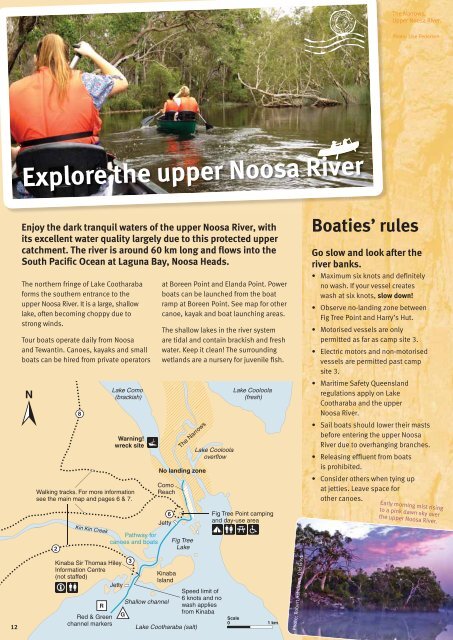
The Narrows,<br />
Upper Noosa River.<br />
Photo: Lise Pedersen<br />
Explore the upper Noosa River<br />
Enjoy the dark tranquil waters <strong>of</strong> the upper Noosa River, with<br />
its excellent water quality largely due to this protected upper<br />
catchment. The river is around 60 km long and flows into the<br />
South Pacific Ocean at Laguna Bay, Noosa Heads.<br />
The northern fringe <strong>of</strong> Lake Cootharaba<br />
forms the southern entrance to the<br />
upper Noosa River. It is a large, shallow<br />
lake, <strong>of</strong>ten becoming choppy due to<br />
strong winds.<br />
Tour boats operate daily from Noosa<br />
and Tewantin. Canoes, kayaks and small<br />
boats can be hired from private operators<br />
2<br />
8<br />
Kin Kin Creek<br />
Lake Como<br />
(brackish)<br />
Warning!<br />
wreck site<br />
Walking tracks. For more information<br />
see the main map and pages 6 & 7.<br />
Pathway for<br />
canoes and boats<br />
at Boreen Point and Elanda Point. Power<br />
boats can be launched from the boat<br />
ramp at Boreen Point. See map for other<br />
canoe, kayak and boat launching areas.<br />
The shallow lakes in the river system<br />
are tidal and contain brackish and fresh<br />
water. Keep it clean! The surrounding<br />
wetlands are a nursery for juvenile fish.<br />
No landing zone<br />
Como<br />
Reach<br />
6<br />
Jetty<br />
The Narrows<br />
Fig Tree<br />
Lake<br />
Lake <strong>Cooloola</strong><br />
overflow<br />
Lake <strong>Cooloola</strong><br />
(fresh)<br />
Fig Tree Point camping<br />
and day-use area<br />
Boaties’ rules<br />
Go slow and look after the<br />
river banks.<br />
• Maximum six knots and definitely<br />
no wash. If your vessel creates<br />
wash at six knots, slow down!<br />
• Observe no-landing zone between<br />
Fig Tree Point and Harry’s Hut.<br />
• Motorised vessels are only<br />
permitted as far as camp site 3.<br />
• Electric motors and non-motorised<br />
vessels are permitted past camp<br />
site 3.<br />
• Maritime Safety Queensland<br />
regulations apply on Lake<br />
Cootharaba and the upper<br />
Noosa River.<br />
• Sail boats should lower their masts<br />
before entering the upper Noosa<br />
River due to overhanging branches.<br />
• Releasing effluent from boats<br />
is prohibited.<br />
• Consider others when tying up<br />
at jetties. Leave space for<br />
other canoes.<br />
Early morning mist rising<br />
to a pink dawn sky over<br />
the upper Noosa River.<br />
12<br />
Kinaba Sir Thomas Hiley<br />
Information Centre<br />
(not staffed)<br />
Jetty<br />
R<br />
Red & Green<br />
channel markers<br />
G<br />
3<br />
Kinaba<br />
Island<br />
Shallow channel<br />
Lake Cootharaba (salt)<br />
Speed limit <strong>of</strong><br />
6 knots and no<br />
wash applies<br />
from Kinaba<br />
Scale<br />
0<br />
1 km<br />
Photo: Robert Ashdown, Qld Govt.


