

Cooloola Recreation Area visitor guide - Department of National ...
Cooloola Recreation Area visitor guide - Department of National ...
Cooloola Recreation Area visitor guide - Department of National ...

You also want an ePaper? Increase the reach of your titles
YUMPU automatically turns print PDFs into web optimized ePapers that Google loves.
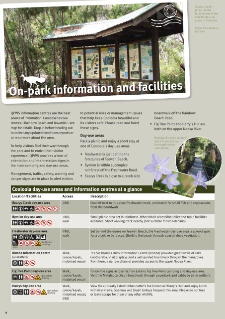
Searys Creek—<br />
picnic in the<br />
bush at one <strong>of</strong> the<br />
smaller day-use<br />
areas in <strong>Cooloola</strong>.<br />
Photo: Rene Burgess,<br />
Qld Govt.<br />
On-park information and facilities<br />
QPWS information centres are the best<br />
source <strong>of</strong> information. <strong>Cooloola</strong> has two<br />
centres—Rainbow Beach and Tewantin—see<br />
map for details. Drop in before heading out<br />
to collect any updated conditions reports or<br />
to read more about the area.<br />
To help <strong>visitor</strong>s find their way through<br />
the park and to enrich their <strong>visitor</strong><br />
experience, QPWS provides a host <strong>of</strong><br />
orientation and interpretation signs in<br />
the main camping and day-use areas.<br />
Management, traffic, safety, warning and<br />
danger signs are in place to alert <strong>visitor</strong>s<br />
<strong>Cooloola</strong> day-use areas and information centres at a glance<br />
Location/Facilities Access Description<br />
to potential risks or management issues<br />
that help keep <strong>Cooloola</strong> beautiful and<br />
its <strong>visitor</strong>s safe. Please read and heed<br />
these signs.<br />
Day-use areas<br />
Pack a picnic and enjoy a short stay at<br />
one <strong>of</strong> <strong>Cooloola</strong>’s day-use areas.<br />
• Freshwater is just behind the<br />
foredunes <strong>of</strong> Teewah Beach.<br />
• Bymien is within subtropical<br />
rainforest <strong>of</strong>f the Freshwater Road.<br />
• Searys Creek is close to a creek-side e<br />
boardwalk <strong>of</strong>f the Rainbow<br />
Beach Road.<br />
• Fig Tree Point and Harry’s Hut are<br />
both on the upper Noosa River.<br />
Boardwalks keep <strong>visitor</strong>s’<br />
feet dry and protect<br />
the fragile creek<br />
side plants.<br />
Photo: Qld Govt.<br />
Photo: Qld Govt.<br />
Searys Creek day-use area 2WD Cool <strong>of</strong>f next to this clear freshwater creek, and watch for small fish and crustaceans<br />
from the boardwalk.<br />
Bymien day-use area<br />
2WD,<br />
walk<br />
Small picnic area set in rainforest. Wheelchair accessible toilet and table facilities<br />
available. Short walking track nearby (not suitable for wheelchairs).<br />
Freshwater day-use area<br />
4WD,<br />
walk<br />
Set behind the dunes on Teewah Beach, the Freshwater day-use area is a good spot<br />
for a picnic or barbecue. Stroll to the beach through coastal dune vegetation.<br />
Cold<br />
Boil before<br />
drinking<br />
Kinaba Information Centre<br />
(unstaffed)<br />
Walk,<br />
canoe/kayak,<br />
motorised vessel<br />
The Sir Thomas Hiley Information Centre (Kinaba) provides great views <strong>of</strong> Lake<br />
Cootharaba. Visit displays and a self-<strong>guide</strong>d boardwalk through the mangroves.<br />
From here, a narrow channel provides access to the upper Noosa River.<br />
Fig Tree Point day-use area<br />
Boil before<br />
drinking<br />
Walk,<br />
canoe/kayak,<br />
motorised vessel<br />
Follow the signs across Fig Tree Lake to Fig Tree Point camping and day-use area.<br />
Visit the Melaleuca circuit boardwalk through paperbark and cabbage palm wetland.<br />
Harrys day-use area<br />
Boil before<br />
drinking<br />
Walk,<br />
canoe/kayak,<br />
motorised vessel,<br />
4WD<br />
View the culturally listed timber-cutter’s hut known as ‘Harry’s Hut’ and enjoy lunch<br />
with river views. Goannas and brush turkeys frequent this area. Please do not feed<br />
or leave scraps for them or any other wildlife.<br />
4


