Chaddock Hall - peel.co.uk
Chaddock Hall - peel.co.uk
Chaddock Hall - peel.co.uk

You also want an ePaper? Increase the reach of your titles
YUMPU automatically turns print PDFs into web optimized ePapers that Google loves.
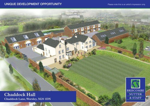
UNIQUE DEVELOPMENT OPPORTUNITY<br />
Please note this is an artist’s impression only<br />
<strong>Chaddock</strong> <strong>Hall</strong><br />
<strong>Chaddock</strong> Lane, Worsley, M28 1DN
Tel: 0161 793 0007<br />
<strong>Chaddock</strong> <strong>Hall</strong>, <strong>Chaddock</strong> Lane<br />
<strong>Chaddock</strong> <strong>Hall</strong> is located off <strong>Chaddock</strong> Lane, Astley, Wigan, Greater Manchester.<br />
It lies between Boothstown to the south, Tyldseley to the north-west and<br />
Astley to the west. The <strong>Hall</strong> is situated within a popular residential area and is in<br />
a highly accessible area, given the close proximity to the A580.<br />
The site is 1.84 acres and includes <strong>Chaddock</strong> <strong>Hall</strong> and its walled garden, the<br />
land to the rear of the <strong>Hall</strong> which was originally laid out as a garden, the land to<br />
the east of the <strong>Hall</strong> and the walled garden <strong>co</strong>ntaining the barn. The site is accessed<br />
via a private driveway off <strong>Chaddock</strong> Lane.<br />
<strong>Chaddock</strong> <strong>Hall</strong> is a <strong>co</strong>untry house dating from the late 16th/early<br />
17th and 18th Centuries. The present building dates from either the late 16th<br />
or early 17th centuries, and as built <strong>co</strong>nsisted of a <strong>Hall</strong> range with two cross<br />
wings, forming an H on plan. The eastern cross wing was demolished in 1878,<br />
when the building was in use as a school. The three storey west wing was built<br />
in 1721. The original west wing was extended at the rear at single storey level<br />
with a large chimney in the early 18th century, and the other rear extensions are<br />
late 18th and 19th century. The H plan building was originally timber framed,<br />
and although most of the external walls have been rebuilt in brick, and the front<br />
and side elevations roughcast rendered, the internal structure, roof and floors<br />
remain substantially intact.<br />
Conversion of the barn into 2 dwellings:<br />
Expressions of Interest<br />
• Unit 15 (Barn Conversion): 826 Sq. Ft - 2 Bedrooms<br />
• Unit 16 (Barn Conversion): 1031 Sq. Ft - 3 Bedrooms<br />
And the creation of 11 new dwellings within the grounds of the <strong>Hall</strong>, Separated<br />
into 3 buildings:<br />
• Units 4 - 6 (House Type A): 771 Sq. Ft -2 Bedrooms<br />
• Units 7 - 11 (House Type B): 794 Sq. Ft -3 Bedrooms<br />
• Units 12 - 14 (House Type C): 1017 Sq. Ft - 3 Bedrooms<br />
The development scheme gained planning approval on the 10th January 2012.<br />
The approved scheme is for:<br />
The <strong>co</strong>nversion of the Grade II Listed <strong>Hall</strong> into 2 dwellings, an extension to the<br />
<strong>Hall</strong> to provide a third dwelling:<br />
• Unit 1 (<strong>Chaddock</strong> <strong>Hall</strong>): 1485 Sq. Ft - 3 Bedrooms<br />
• Unit 2 (<strong>Chaddock</strong> <strong>Hall</strong>): 1571 Sq. Ft - 4 Bedrooms<br />
• Unit 3 (<strong>Chaddock</strong> <strong>Hall</strong>): 1485 Sq. Ft - 4 Bedrooms<br />
9 Barton Road, Worsley, Manchester M28 2PD www.bnands.<strong>co</strong>.<strong>uk</strong><br />
homes@bnands.<strong>co</strong>.<strong>uk</strong>
Tel: 0161 793 0007<br />
Further Documents<br />
Below is a schedule of <strong>co</strong>nsultants and architects who have designed this<br />
scheme:<br />
• Hayes and Partners – Architects<br />
• Peter De Figueiredo – Historical Buildings Adviser<br />
• Emery Planning Partnership<br />
• Rob Smith – E<strong>co</strong>logical <strong>co</strong>nsultant<br />
The following documents are are available upon request:<br />
i. Planning Decision Notice<br />
ii. Topographical Survey<br />
iii. Protected Species Phase 1 Report<br />
iv. Protected Species Newt Survey<br />
v. Planning Statement<br />
vi. Design and Access Statement<br />
vii. Renewable Energy Statement<br />
viii. <strong>Chaddock</strong> <strong>Hall</strong> – Survey Drawings of House<br />
ix. <strong>Chaddock</strong> <strong>Hall</strong> – Survey Drawings of House Elevations<br />
x. <strong>Chaddock</strong> <strong>Hall</strong> – Survey Drawing of Barn<br />
xi. <strong>Chaddock</strong> <strong>Hall</strong> – Site Plan As Proposed<br />
xii. <strong>Chaddock</strong> <strong>Hall</strong> – House Type A As Proposed<br />
xiii. <strong>Chaddock</strong> <strong>Hall</strong> – House Type B As Proposed<br />
xiv. <strong>Chaddock</strong> <strong>Hall</strong> – House Type C As Proposed<br />
xv. <strong>Chaddock</strong> <strong>Hall</strong> – South Elevation of <strong>Chaddock</strong> <strong>Hall</strong> & House type<br />
9 Barton Road, Worsley, Manchester M28 2PD www.bnands.<strong>co</strong>.<strong>uk</strong><br />
homes@bnands.<strong>co</strong>.<strong>uk</strong>
This material has been reproduced from<br />
Ordnance Survey digital map data with<br />
the permission of the Controller of<br />
Her Majesty's Stationery Office.<br />
© Crown <strong>co</strong>pyright.<br />
Licence Number 100018033<br />
SALES & LETTINGS AGENT<br />
Playing Field<br />
43<br />
13<br />
40<br />
17<br />
48<br />
Path (um)<br />
25<br />
52<br />
Drain<br />
Path (um)<br />
Park Lane<br />
Holy Family RC Primary School<br />
Pond<br />
<strong>Hall</strong><br />
Tank<br />
<strong>Chaddock</strong> <strong>Hall</strong><br />
246<br />
234<br />
Holy Family<br />
RC Church<br />
Presbytery<br />
Holy Family<br />
RC Church<br />
208<br />
38.1m<br />
Presbytery<br />
CHADDOCK LANE<br />
235<br />
227<br />
El Sub Sta<br />
213<br />
Tanks<br />
Location Plan: <strong>Chaddock</strong> <strong>Hall</strong>, Off <strong>Chaddock</strong> Lane<br />
Astley, Wigan<br />
Scale 1:50000<br />
@ A4<br />
Date: 14:10:10<br />
Industrial<br />
Estate<br />
Red Edge<br />
<strong>Chaddock</strong> <strong>Hall</strong><br />
Off <strong>Chaddock</strong> Lane<br />
Astley, Wigan<br />
Scale 1:1250<br />
@ A4<br />
Date: 14:10:10<br />
EAST LANCASHIRE ROAD<br />
This material has been reproduced from<br />
Ordnance Survey digital map data with<br />
the permission of the Controller of<br />
Her Majesty's Stationery Office.<br />
© Crown <strong>co</strong>pyright.<br />
Licence Number 100018033<br />
32.9m<br />
Bris<strong>co</strong>mbe Nutter & Staff - 0161 793 0007