flood level data for River Avon and Flood Zone Maps
flood level data for River Avon and Flood Zone Maps
flood level data for River Avon and Flood Zone Maps

You also want an ePaper? Increase the reach of your titles
YUMPU automatically turns print PDFs into web optimized ePapers that Google loves.
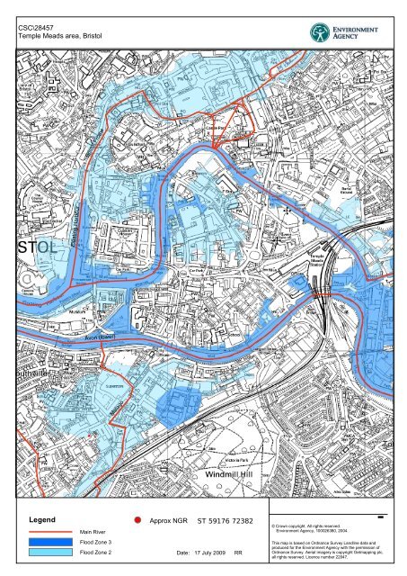
CSC\28457<br />
Temple Meads area, Bristol<br />
Bristol Frome<br />
Floating Harbour<br />
<strong>Avon</strong> (lower)<br />
Malago<br />
Legend<br />
Main <strong>River</strong><br />
<strong>Flood</strong> <strong>Zone</strong> 3<br />
<strong>Flood</strong> <strong>Zone</strong> 2<br />
Approx NGR ST 59176 72382<br />
Date: 17 July 2009 RR<br />
¯<br />
© Crown copyright. All rights reserved.<br />
Environment Agency, 100026380, 2004.<br />
This map is based on Ordnance Survey L<strong>and</strong>line <strong>data</strong> <strong>and</strong><br />
produced <strong>for</strong> the Environment Agency with the permission of<br />
Ordnance Survey. Aerial imagery is copyright Getmapping plc,<br />
all rights reserved. Licence number 22047.