The Democratic Domino Theory: An Empirical Investigation
The Democratic Domino Theory: An Empirical Investigation
The Democratic Domino Theory: An Empirical Investigation

Create successful ePaper yourself
Turn your PDF publications into a flip-book with our unique Google optimized e-Paper software.
538 PETER T. LEESON AND ANDREA M. DEAN<br />
period grow slower in terms of democracy the following<br />
period, will be positive, suggesting “democratic<br />
divergence.”<br />
W is an N × N spatial weight matrix based on firstdegree<br />
contiguity (bordering geographic neighbors). For<br />
example, since the United States has two contiguous geographic<br />
neighbors, Canada and Mexico, each of these<br />
countries receives a weight of 1/2 in the spatial weight matrix,<br />
W, as America’s geographic neighbors. This feature<br />
of the model makes it ideal to test the democratic domino<br />
theory since, as Johnson points out, this theory explicitly<br />
“linked geography to politics by assuming that the political<br />
fate of ...a nation would inevitably affect the fate of<br />
contiguous nations in a continuous chain fashion” (1985,<br />
39). , our parameter of interest in the SAR model, is the<br />
spatial autoregressive coefficient. It measures the spread<br />
of changes in democracy between geographic neighbors.<br />
If democracy spreads as the democratic domino<br />
theory suggests, this coefficient should be positive and<br />
significant.<br />
Our SEM model takes the form:<br />
D t = + D t−5 + X + ε t ; Wε t + t<br />
where our parameter of interest is , the spatial autocorrelation<br />
coefficient, which measures the spread of democracy<br />
using the SEM model.<br />
One nice feature of the geography-based democratic<br />
domino theory for the purposes of empirical investigation<br />
is that, since it is geography-based, we do not need<br />
to worry about the potential for endogeneity bias. Geography<br />
is exogenous. Countries cannot choose their<br />
geographic location and are thus unable to affect who<br />
they have as geographic neighbors. This removes reverse<br />
causality as a concern for our spatial estimates.<br />
<strong>The</strong> biggest disadvantage of investigating the spread<br />
of democracy geographically is the question of how to<br />
deal with islands, which have no contiguous geographic<br />
neighbors. Because of this, in the full sample the geographic<br />
spatial weight matrix contains values of zero when<br />
predicting changes in democracy of islands. 5 We address<br />
this issue in two ways. First, we run our regressions on<br />
the entire sample treating islands as countries without<br />
neighbors and include a binary variable that controls for<br />
island status. Second, as a robustness check we estimate<br />
both spatial models excluding islands from the sample to<br />
5 <strong>The</strong> fact that islands have values of zero in W does not pose a<br />
problem for performing our estimation because W does not enter<br />
directly into the regression. W, recall, is multiplied by D t in the<br />
SAR model, and by t in the SEM model. This matrix multiplication<br />
results in a column vector of values that enter the regression.<br />
In the case of an island, the value in the corresponding row of this<br />
column is zero. Of course, all of the nonislands represented in the<br />
other rows of this column will have nonzero values.<br />
ensure that treating islands this way does not affect our<br />
estimates. 6 <strong>The</strong> results of this robustness check are discussed<br />
in the sixth section, which performs a sensitivity<br />
analysis of our spatial regressions.<br />
Does Democracy Spread? <strong>The</strong><br />
Evidence at a Glance<br />
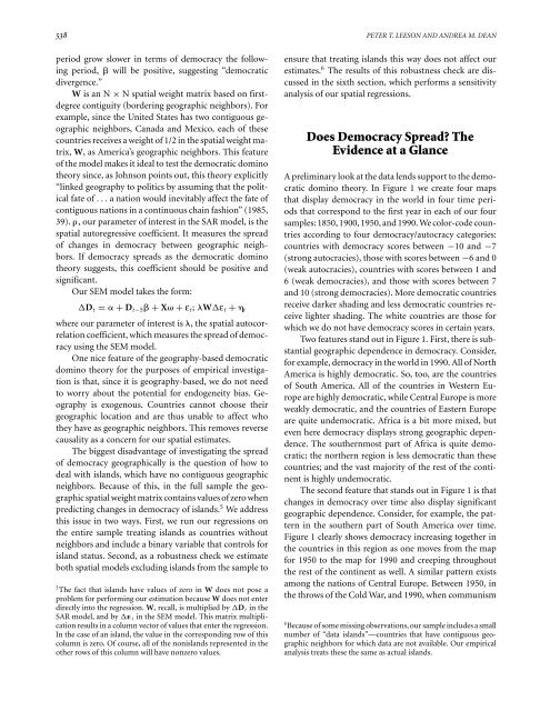
A preliminary look at the data lends support to the democratic<br />
domino theory. In Figure 1 we create four maps<br />
that display democracy in the world in four time periods<br />
that correspond to the first year in each of our four<br />
samples: 1850, 1900, 1950, and 1990. We color-code countries<br />
according to four democracy/autocracy categories:<br />
countries with democracy scores between −10 and −7<br />
(strong autocracies), those with scores between −6and0<br />
(weak autocracies), countries with scores between 1 and<br />
6 (weak democracies), and those with scores between 7<br />
and 10 (strong democracies). More democratic countries<br />
receive darker shading and less democratic countries receive<br />
lighter shading. <strong>The</strong> white countries are those for<br />
which we do not have democracy scores in certain years.<br />
Two features stand out in Figure 1. First, there is substantial<br />
geographic dependence in democracy. Consider,<br />
for example, democracy in the world in 1990. All of North<br />
America is highly democratic. So, too, are the countries<br />
of South America. All of the countries in Western Europe<br />
are highly democratic, while Central Europe is more<br />
weakly democratic, and the countries of Eastern Europe<br />
are quite undemocratic. Africa is a bit more mixed, but<br />
even here democracy displays strong geographic dependence.<br />
<strong>The</strong> southernmost part of Africa is quite democratic;<br />
the northern region is less democratic than these<br />
countries; and the vast majority of the rest of the continent<br />
is highly undemocratic.<br />
<strong>The</strong> second feature that stands out in Figure 1 is that<br />
changes in democracy over time also display significant<br />
geographic dependence. Consider, for example, the pattern<br />
in the southern part of South America over time.<br />
Figure 1 clearly shows democracy increasing together in<br />
the countries in this region as one moves from the map<br />
for 1950 to the map for 1990 and creeping throughout<br />
the rest of the continent as well. A similar pattern exists<br />
among the nations of Central Europe. Between 1950, in<br />
the throws of the Cold War, and 1990, when communism<br />
6 Because of some missing observations, our sample includes a small<br />
number of “data islands”—countries that have contiguous geographic<br />
neighbors for which data are not available. Our empirical<br />
analysis treats these the same as actual islands.