Q1 Presentation - PGS
Q1 Presentation - PGS
Q1 Presentation - PGS

Create successful ePaper yourself
Turn your PDF publications into a flip-book with our unique Google optimized e-Paper software.
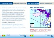
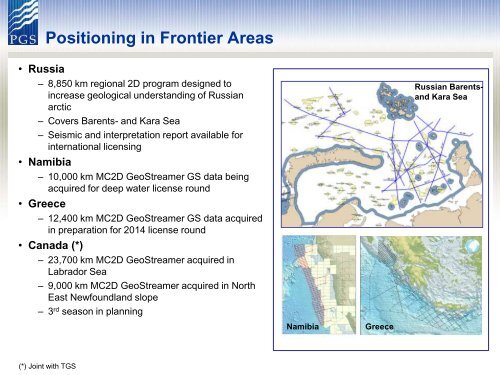
Positioning in Frontier Areas<br />
• Russia<br />
– 8,850 km regional 2D program designed to<br />
increase geological understanding of Russian<br />
arctic<br />
– Covers Barents- and Kara Sea<br />
– Seismic and interpretation report available for<br />
international licensing<br />
• Namibia<br />
– 10,000 km MC2D GeoStreamer GS data being<br />
acquired for deep water license round<br />
• Greece<br />
– 12,400 km MC2D GeoStreamer GS data acquired<br />
in preparation for 2014 license round<br />
• Canada (*)<br />
– 23,700 km MC2D GeoStreamer acquired in<br />
Labrador Sea<br />
– 9,000 km MC2D GeoStreamer acquired in North<br />
East Newfoundland slope<br />
– 3 rd season in planning<br />
Russian Barentsand<br />
Kara Sea<br />
Namibia<br />
Greece<br />
(*) Joint with TGS