Paulinskill Valley Trail (2011) - Rails-to-Trails Conservancy
Paulinskill Valley Trail (2011) - Rails-to-Trails Conservancy
Paulinskill Valley Trail (2011) - Rails-to-Trails Conservancy
You also want an ePaper? Increase the reach of your titles
YUMPU automatically turns print PDFs into web optimized ePapers that Google loves.
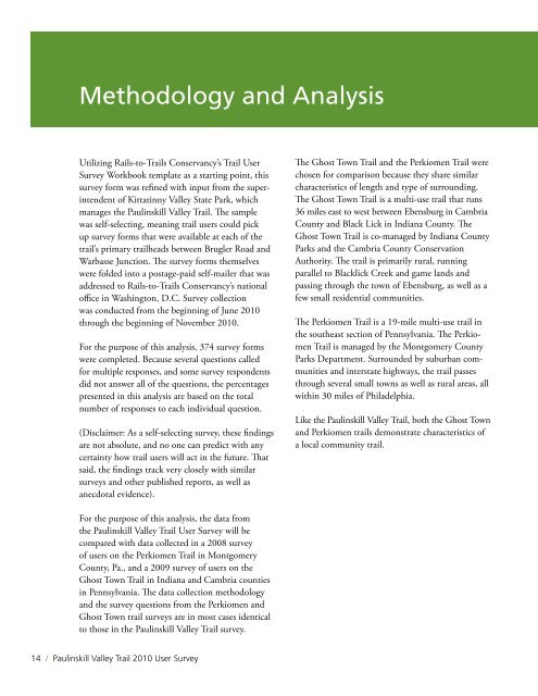
Methodology and Analysis<br />
Utilizing <strong>Rails</strong>-<strong>to</strong>-<strong>Trail</strong>s <strong>Conservancy</strong>’s <strong>Trail</strong> User<br />
Survey Workbook template as a starting point, this<br />
survey form was refined with input from the superintendent<br />
of Kittatinny <strong>Valley</strong> State Park, which<br />
manages the <strong>Paulinskill</strong> <strong>Valley</strong> <strong>Trail</strong>. The sample<br />
was self-selecting, meaning trail users could pick<br />
up survey forms that were available at each of the<br />
trail’s primary trailheads between Brugler Road and<br />
Warbasse Junction. The survey forms themselves<br />
were folded in<strong>to</strong> a postage-paid self-mailer that was<br />
addressed <strong>to</strong> <strong>Rails</strong>-<strong>to</strong>-<strong>Trail</strong>s <strong>Conservancy</strong>’s national<br />
office in Washing<strong>to</strong>n, D.C. Survey collection<br />
was conducted from the beginning of June 2010<br />
through the beginning of November 2010.<br />
For the purpose of this analysis, 374 survey forms<br />
were completed. Because several questions called<br />
for multiple responses, and some survey respondents<br />
did not answer all of the questions, the percentages<br />
presented in this analysis are based on the <strong>to</strong>tal<br />
number of responses <strong>to</strong> each individual question.<br />
(Disclaimer: As a self-selecting survey, these findings<br />
are not absolute, and no one can predict with any<br />
certainty how trail users will act in the future. That<br />
said, the findings track very closely with similar<br />
surveys and other published reports, as well as<br />
anecdotal evidence).<br />
The Ghost Town <strong>Trail</strong> and the Perkiomen <strong>Trail</strong> were<br />
chosen for comparison because they share similar<br />
characteristics of length and type of surrounding.<br />
The Ghost Town <strong>Trail</strong> is a multi-use trail that runs<br />
36 miles east <strong>to</strong> west between Ebensburg in Cambria<br />
County and Black Lick in Indiana County. The<br />
Ghost Town <strong>Trail</strong> is co-managed by Indiana County<br />
Parks and the Cambria County Conservation<br />
Authority. The trail is primarily rural, running<br />
parallel <strong>to</strong> Blacklick Creek and game lands and<br />
passing through the <strong>to</strong>wn of Ebensburg, as well as a<br />
few small residential communities.<br />
The Perkiomen <strong>Trail</strong> is a 19-mile multi-use trail in<br />
the southeast section of Pennsylvania. The Perkiomen<br />
<strong>Trail</strong> is managed by the Montgomery County<br />
Parks Department. Surrounded by suburban communities<br />
and interstate highways, the trail passes<br />
through several small <strong>to</strong>wns as well as rural areas, all<br />
within 30 miles of Philadelphia.<br />
Like the <strong>Paulinskill</strong> <strong>Valley</strong> <strong>Trail</strong>, both the Ghost Town<br />
and Perkiomen trails demonstrate characteristics of<br />
a local community trail.<br />
For the purpose of this analysis, the data from<br />
the <strong>Paulinskill</strong> <strong>Valley</strong> <strong>Trail</strong> User Survey will be<br />
compared with data collected in a 2008 survey<br />
of users on the Perkiomen <strong>Trail</strong> in Montgomery<br />
County, Pa., and a 2009 survey of users on the<br />
Ghost Town <strong>Trail</strong> in Indiana and Cambria counties<br />
in Pennsylvania. The data collection methodology<br />
and the survey questions from the Perkiomen and<br />
Ghost Town trail surveys are in most cases identical<br />
<strong>to</strong> those in the <strong>Paulinskill</strong> <strong>Valley</strong> <strong>Trail</strong> survey.<br />
14 / <strong>Paulinskill</strong> <strong>Valley</strong> <strong>Trail</strong> 2.010 User Survey


