Pride Campaign Site Summary Country Philippines ... - RarePlanet
Pride Campaign Site Summary Country Philippines ... - RarePlanet
Pride Campaign Site Summary Country Philippines ... - RarePlanet

You also want an ePaper? Increase the reach of your titles
YUMPU automatically turns print PDFs into web optimized ePapers that Google loves.
<strong>Pride</strong> <strong>Campaign</strong> <strong>Site</strong> <strong>Summary</strong><br />
<strong>Country</strong><br />
Province<br />
Municipality<br />
Barangays<br />
<strong>Site</strong><br />
Description<br />
Climate<br />
Biodiversity<br />
Area<br />
Biodiversity<br />
Background<br />
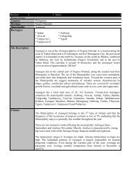
<strong>Philippines</strong><br />
Zamboanga Sibugay<br />
Ipil<br />
Buluan, Makilas, Caparan, Tiayon, Magdaup, Bangkerohan, Sanito, Pangi,<br />
Upper Pangi and Tenan<br />
The Municipality is composed of twenty eight (28) barangays. It is bounded on<br />
the north by the municipality of Titay, on the south by the Sibuguey<br />
Bay; on the west by the municipalities of R. T. Lim and Tungawan; and<br />
on the east by the municipality of Naga which is defined by the Bacalan<br />
River.<br />
The Municipality of Ipil is located in the northwestern section of the<br />
Province of Zamboanga Sibugay (2nd congressional district). The<br />
Municipality’s strategic location is what makes it advantageous in its pursuit to<br />
become a self-sufficient locality, besides being the capital town of the newly<br />
created province of Zamboanga Sibugay. It lies at the crossroad between the<br />
Pagadian City-Zamboanga City and Dipolog City route, which is the national<br />
highway. It is approximately situated at 135 kilometers west of Pagadian<br />
City (the capital city of the Province of Zamboanga del Sur); 139 kilometer east<br />
of Zamboanga City (the regional center) and 177 kilometers south of<br />
Dipolog City (the capital city of Zamboanga del Norte). The Municipality<br />
is at the geographical coordinates of 122 35’ longitudes and 7 47’ latitude.<br />
It has an elongated regular shape about 21x7 km. (2010, Municipal Profile)<br />
Ipil’s climatic condition is of the fourth type with distinct wet and dry seasons.<br />
This character is common to all Zamboanga Sibugay areas. Usually, the period<br />
between the months of December to April is considered dry season for Ipil while<br />
rainy season starts from the months of May to November.<br />
The twenty one (21) years of daily rainfall record from year 1980 to 2001 kept at<br />
WESMIARC shows that the total annual rainfall averages to 1,933.53 millimeters<br />
with 1,211.25 mm being the lowest in 1990 and 2,812.12 mm as the highest on<br />
the same year. The wettest months are June to September with an average<br />
monthly rainfall ranging from 313.15 to 270.48 mm. The driest months are<br />
January to March with an average monthly rainfall ranging from 39.93 to 50.19<br />
mm. (2010, Ipil Municipal Profile)<br />
Municipal land: 36,690 has.<br />
Municipal waters: 16,800 has. (est.)<br />
Coral Reef Area: (No Data Yet)<br />
Seagrass area: (No Data Yet )<br />
Fisheries Area: (No Data Yet)<br />
Mangrove Area: 2185.92 has<br />
Wetlands Area: no wetland<br />
Data generated from previous bio-physical assessments conducted by the<br />
Zamboanga State College of Marine Sciences and Technology and Department of<br />
Agrarian Reform-Western Mindanao Community Initiatives Project (DAR-<br />
WMCIP) in 2003 and EcoGov 2 in 2007 respectively are as follows:
Coral reef: biophysical status, unique species, coral species count.<br />
Corals 2003 2007<br />
Dead Corals: 55.5% 16.58%<br />
Hard Corals: 28.5% 61.58%<br />
Sand/rubbles: 12.5% 21.51%<br />
Soft Corals: 0.16% 3.50%<br />
Fig. 1. Coral cover of Buluan Island Marine Sanctuary.<br />
NoNote: Presence of near threatened species of coral Cynarina lacrymalis<br />
1. Seagrass: biophysical status, unique species, count of species.<br />
Species D F C<br />
H. pinifolia 10.6 4 0.422<br />
H. ovalis 19.2 6.6 0.74<br />
H. uninervis 306 27 15.948<br />
E. acoroides 7.2 18 11.54<br />
T. hemprichii 15.6 11.6 3.4<br />
C. serrulata 57 23.2 9.102<br />
TOTAL 415.6 90.4 41.152<br />
Fig. 2 Sea-grass present in the sanctuary.<br />
2. Mangrove ecosystem: biophysical status, unique species, count.<br />
COMMON NAME<br />
SCIENTIFIC NAME<br />
Pagatpat<br />
Sonneratia alba<br />
Pedada<br />
Sonneratia caseolaris<br />
Bakauan babae<br />
Rhizopora mucronata<br />
Bakauan lalaki<br />
Rhizopora apiculata<br />
Busain<br />
Bruguiera gymnorhiza<br />
Langarai<br />
Bruguiera parviflora<br />
Bungalon puti<br />
Avicennia alba<br />
Nipa<br />
Nypa pruticans<br />
Tabigi<br />
Xylocarpus granatum<br />
Saging-saging<br />
Aegiceras corniculatum<br />
Fern<br />
Acrostichum speciosum<br />
Tigbau<br />
Acanthus ebracteatus<br />
Pototan-<br />
Bruguiera cylindricax<br />
Buta-buta<br />
Excoecaria agallocha<br />
Dungon<br />
Heritiera littoralis<br />
Api-api<br />
Avicennia officinalis<br />
Fig. 3. Mangrove species in Ipil, Zamboanga Sibugay (2007, PCRA)
Other species of fish, reptiles and bivalves found in the site<br />
includes the following; sword fish and jacks, green sea turtle and giant clams.<br />
Provide<br />
information on<br />
the unique<br />
species you<br />
listed above and<br />
their importance<br />
to ecology,<br />
people, tourism,<br />
and fishing.<br />
The corals found in the Buluan Island Marine Sanctuary (Fig.1) are the only<br />
remaining good coral cover in the site (municipality). Other corals outside of the<br />
sanctuary are mostly turned into rubbles due to dynamite fishing or dragged by<br />
nets. The health of these corals relates to myriad of benefits to the fishers ranging<br />
from supply of fish, protection from storm surges, climate change resiliency, ecotourism<br />
potential and many other benefits.<br />
corals<br />
Reef fishes<br />
Seagrasses on the otherhand, provides benefits to coastal communities and fishers<br />
by stabilizing sea bed and preventing coastal erosion. It also slow down watercurrent<br />
and provides food and shelter to fishes.<br />
Mangroves in the site as shown in the picture below. It offer various benefits to<br />
the fishers and coastal communities especialy in terms of providing protection<br />
from storm surges, source of food and as shelter and breeding ground of fish,<br />
crustaceans and reptiles among others.<br />
Other endangered or threatened species found in the site and the sanctuary like<br />
green turtle, giant clams and other corals are other marine species the LGU<br />
of Ipil is determined to protect.
Tridacna gigas<br />
Green Sea Turtle<br />
Cynarina lacrymalis<br />
Moray eel<br />
MPA overview<br />
Technical<br />
Description of<br />
MPAs<br />
Fig. 4. The technical description of the Buluan Island Marine<br />
Sanctuary,Ipil, Zamboanga Sibugay, <strong>Philippines</strong>
7.8<br />
7.78<br />
FZ<br />
FZ<br />
MZ<br />
FZ<br />
MZ<br />
7.76<br />
7.74<br />
FZ<br />
FZ<br />
MZ<br />
FZ<br />
FZ<br />
MPZ<br />
MZ<br />
MPZ<br />
MPZ<br />
MZ<br />
MZ<br />
MZ<br />
MZ<br />
7.72<br />
MZ<br />
FZ<br />
MZ<br />
MPZ<br />
MPZ<br />
7.7<br />
7.68<br />
MPZ<br />
7.66<br />
122.5 122.52 122.54 122.56 122.58 122.6 122.62 122.64 122.66 122.68<br />
Fig. 5. The zonified municipal waters of Ipil including the navigitional<br />
Lanes represented by arrows. The biggest red square is where the<br />
location of the Buluan Island Marine Sanctuary and the smaller red<br />
squares are the proposed MPAs.(2010-2018, Coastal Resource<br />
Management Plan of Ipil)<br />
<strong>Site</strong> Map<br />
Reference<br />
Fig. 6. Aerial view of the Buluan Island Marine Sanctuary, Ipil,<br />
Zamboanga Sibugay Province, <strong>Philippines</strong> .<br />
Google Map Link:<br />
http://maps.google.com.ph/maps?hl=fil&newwindow=1&biw=1366&bih=664&n<br />
oj=1&q=ipil+zamboanga+sibugay&um=1&ie=UTF-<br />
8&hq&hnear=0x3253d88b598cdea3%3A0x8e3409df72f1213c%2CBayan+ng+Ip<br />
il&gl=ph&sa=X&ei=R4xVUNXPGaLNmAXSzYCgAQ&ved=0CDgQ8gEwAw
Fig. 7 Shows the location of the municipality of Ipil, Zamboanga Sibugay<br />
Province. <strong>Philippines</strong><br />
Fig. 8. Administrative map of the municipality of Ipil.<br />
Protected Area<br />
Categories<br />
The Buluan Island Marine Sanctuary (BIMS), is a coral reef marine sanctuary<br />
established thru Municipal Fishery Ordinance # 09-214-2006.
Red- List<br />
Species<br />
Primary<br />
Threats<br />
Secondary<br />
Threats<br />
History of the<br />
MPA<br />
IUCN Red Data list can be accessed here: http://www.iucnredlist.org/<br />
1. Cynarina lacrymalis (near threatened)<br />
2. Tridacna gigas (vulnerable A2 cd. Ver.2.3)<br />
3. Acropora spp. (near threatened/vulnerable)<br />
IUCN Threat Classification can be accessed here, or in Appendix A:<br />
http://www.iucnredlist.org/technical-documents/classification-schemes/threatsclassification-scheme-ver3<br />
o 5.4 Fishing & harvesting aquatic resources<br />
• 5.4.1 Intentional mortality (human use - subsistence/small scale)<br />
IUCN Threat Classification can be accessed here, or in Appendix A:<br />
http://www.iucnredlist.org/technical-documents/classification-schemes/threatsclassification-scheme-ver3<br />
o<br />
o<br />
o<br />
o<br />
o<br />
o<br />
3.2 Mining & quarrying<br />
8.2 Problematic native species<br />
9.3.2 Soil erosion, sedimentation<br />
9.4 Garbage & solid waste<br />
11.3 Temperature extremes<br />
The idea for establishment of the Buluan Island Marine Sanctuary started when<br />
fishers of barangay Buluan and Makilas of the municipality of Ipil, Zamboanga<br />
Sibugay Province suggested it during several resource assessment and<br />
development planning activities sponsored by the Department of Agrarian<br />
Reform (DAR) thru the Western Mindanao Community Initiatives Project<br />
(WMCIP), an International Fund for Agricultural Development (IFAD) funded<br />
project in year 2001. During several focused group discussion sessions, the<br />
decreasing trend in fish catch among fishers of the said barangays prompted<br />
them to request to establish a sanctuary for fish to repopulate and breed.<br />
With the support of the barangay council of Buluan, a barangay resolution was<br />
passed to the municipal government requesting for the establishment of a 10 has.<br />
“fish sanctuary”<br />
The municipal local government unit of Ipil thru the Municipal Agriculture<br />
Office together with DAR-WMCIP acted on it by providing budget for the<br />
establishment of artificial reefs within the island in 2003.<br />
The Zamboanga State College of Marine Science and Technology thru the<br />
funding of DAR-WMCIP conducted a survey in the island last August 2003<br />
together with the participating agencies like the Xavier Agriculture Extension<br />
Service (XAES), fisherfolks and barangay officials of Barangay Makilas and<br />
Buluan..<br />
In 2004, a Memorandum of Agreement was signed between the DAR-WMCIP,<br />
Local Government Unit of Ipil and other stakeholders agreeing to provide<br />
technical and logistic support for the establishment of a sanctuary<br />
Launching of Buluan Island as a marine sanctuary was on March 10, 2004 were<br />
markers and buoys were deployed,<br />
In September 2006, thru Municipal Fishery Ordinance # 09-214-2006, the<br />
Buluan Island Marine Sanctuary was officially declared.
2007-2010, USAID-EcoGov2 of also assisted the municipality in improving the<br />
governance systems of the sanctuary.<br />
2012-up to the present, the marine sanctuary continues to function.<br />
Previous and<br />
Existing<br />
Management<br />
Strategies<br />
The assisting non-government organization (NGO) that helped in the<br />
establishment of the marine sanctuary is the Xavier Agriculture Extension<br />
Service (XAES) based in Ipil, Zamboanga Sibugay, an extension unit of Xavier<br />
Science Foundation (XSF) of Xavier University, Cagayan De Oro, <strong>Philippines</strong><br />
thru the Department of Agrarian Reform (DAR) assisted, International Fund for<br />
Agricultural Development funded Western Mindanao Community Initiatives<br />
Project (WMCIP).<br />
The project started in 2001 and ended in 2005. The objectives of the project was<br />
to capacitate communities to formulate plans and programs using participatory<br />
approach and establish conservation sites as part of the natural resource<br />
management component. XAES took care of the organizing component while<br />
DAR-WMCIP Project <strong>Site</strong> Operations Unit on the other hand provided funds for<br />
the participatory coastal resource assessment (PCRA),the provision of patrol boat<br />
with engine, diving gears, buoys and markers, ropes, anchor and others. The area<br />
declared as sanctuary is 63.16 hectares.<br />
In 2007-2010, the USAID funded Ecological Governance 2 Project (EcoGov2)<br />
also assisted the local government of Ipil in strengthening of the MPA<br />
management structure (TWG), formulation of a long-term coastal resource<br />
management plan including the formulation of a separate MPA Plan and conduct<br />
of regular bio-physical assessment activities.<br />
From 2010 up to the present, the local government of Ipil took full responsibility<br />
on the management of the sanctuary by assigning regular “Bantay Dagat” and<br />
“Sanctuary Guards” personnel for a 24/7 monitoring. Apprehensions were also<br />
recorded. Funds allocated ranges from PhP 600,000-800,000 annually (Source:<br />
Ipil Budget Office).
Previous and<br />
Existing<br />
Environmental<br />
Education<br />
Work<br />
The local government of Ipil thru the Office of the Municipal Agriculturists<br />
and the Municipal Environment and Natural Resources Officer are conducting the<br />
following environmental and educational works in relation to sanctuary and<br />
coastal resource management :<br />
A. Environmental Works<br />
• Re-installation of lost marker buoys<br />
• Installation of fish aggregating devices<br />
• Repair/Construction of guard houses and sign boards<br />
• Purchase of additional patrol boats and equipment such as two (2)-way<br />
handheld radio, binocular, flash lights, masks and snorkels, life jackets<br />
• Regular patrolling (24/7)<br />
• Apprehension and prosecution of sanctuary intruders or commercial fisher<br />
intruding the municipal waters<br />
• Regular reef assessment (every 3 months)<br />
• Conduct of island and underwater clean-ups<br />
B. Educational Works<br />
• Advocacy to different coastal communities thru power point presentations<br />
during 4P’s Family Development Sessions (FDS)<br />
• Presentation of CRM activities thru transparency boards, tarpaulins, LGU<br />
website and LGU Facebook account<br />
• Regular radio plugging on DXIR 94.3 FM and DXLR 98.1 FM Radio<br />
Stations on the existence of the marine sanctuary and its benefits<br />
• Inclusion of the Buluan Island Marine Sanctuary information to provincial<br />
and local tourism flyers<br />
• Hosting island visits for church workers, students, government workers and<br />
other stakeholders<br />
Human Stakeholders<br />
Human<br />
Stakeholder<br />
Population<br />
Size<br />
Historical<br />
Description<br />
Based on latest population census of the National Statistics Office (NSO, 2010),<br />
the municipality of Ipil has a total population of 64,939.<br />
Of the total 28 barangays comprising Ipil, there are 10 are considered as coastal<br />
barangays whose population may directly benefitted of the <strong>Pride</strong> <strong>Campaign</strong><br />
considering that many of the fishers in these areas fish near the MPA. The<br />
combined population of these coastal barangays is 26,312 out of 6397<br />
households.<br />
Background<br />
Ipil was formerly known as “Nito”, a sitio in barrio Bacalan of the municipality<br />
of Kabasalan. The name “Nito” came from the famous hats and baskets woven<br />
out of the nito vines that grew in abundance along the Bacalan River. From<br />
“Nito”, the name evolved to “Sanito”. Presumably because when the locals<br />
where asked where they were heading, they often replied “Sa Nito”, meaning,<br />
“To Nito”. In the early days the inhabitants of Sanito were from the Subanon<br />
tribe. A Balian or Priest named Balian Dagatan headed them. They were pagans<br />
then, and worshiped the sun, the moon, stars, rivers and even the big trees found
in their village. The Subanons engaged in barter trade with the Chinese Traders<br />
who usually exchange jars, plates, trinkets, brassware, coins and others, with<br />
spices and other agricultural products found in their village. Later on, the<br />
Subanon intermarried with people from different faiths, making its inhabitants<br />
today a rich mix of people with diverse beliefs but living in harmony with each<br />
other.<br />
<strong>Campaign</strong>'s<br />
Social Context<br />
Executive Order No. 249 was signed by then President Elpidio Quirino on July<br />
26, 1949. This presidential act made the place now known as Ipil a full-fledged<br />
municipality. (2010, Ipil Municipal Profile)<br />
Socio-economic Profile<br />
The municipality of Ipil is the economic, industrial and institutional center of the<br />
newly created province of Zamboanga Sibugay. A First class municipality, it<br />
thrives on agriculture, fishery, commerce and trade as the major sources of<br />
income.<br />
Year 2009 Total Income - P 108,870,119.00<br />
(IRA – P82,663,364.00; Local Sourced Revenues – P24,252,306.14;<br />
Other Sources P 1,954,448.56)<br />
Year 2010 Total Income – P122,850,413.17<br />
(IRA – P83,172,894.00; Local Sourced Revenues – P35,462,715.61;<br />
Other Sources – P4,214,803.56)<br />
Major Products - Rubber<br />
Major Industries - Rubber Processing<br />
Major Tribe - Visayan<br />
Cultural Tribe - Muslim and Subanen<br />
Dialect Spoken - Cebuano<br />
Major Religion - Roman Catholic<br />
Topographical Description<br />
The municipality lies along the south coast of the Zamboanga Peninsula and is<br />
mostly flat to rolling, though high metamorphic and volcanic hills in the<br />
Municipality’s west and northwest comprise the foothills and sideslopes of the<br />
adjoining Quipit Peak and Mount Silingan whose twin crests are a major physical<br />
feature in this region.<br />
Resource Profile:<br />
Land Resource:<br />
a. Major Land forms:<br />
- hilly to rolling landscapes<br />
- alluvial lands and marsh and tidal flat<br />
b. Soil Classification:<br />
There are three major types of soil in the municipality, such as:<br />
castilla clay loam, hydrosol and antipolo type, each associated with a<br />
different parent material and corresponding terrain.
The great majority of soils in the municipality are derived from<br />
sediments, particularly underlying limestone, and occur as weakly<br />
structured brown to yellowish brown clays or clay loam top soils<br />
overlying yellow-brown decomposing limestone in the subsoil<br />
Soils on steeper elevated hills to northwest, such as barangays Timalang,<br />
Maasin, Labi and Doña Josefa, are acid, mostly shallow to very shallow and<br />
stony yellow brown clay loam with low organic matter, very low P and K.<br />
They are limited by inadequate depth, stone and low fertility, and on steep<br />
slopes are prone to erosion.<br />
c. Land Classification:<br />
Built –up area - 449 has. -<br />
Agricultural/cropland - 18,622 has.<br />
Forest lands - 3,354 has.<br />
Mangroves/Marshes - 2,185 has.<br />
- Timber land and Watershed - 12,132 has.<br />
Natural Resources:<br />
a. Water Resources:<br />
Water District : Caparan, Taway, Bacalan Spring;<br />
Ipil Heights Spring, Buluan Spring<br />
Legislative<br />
Context<br />
b. Fishery Resources : Sibuguey Bay<br />
(2010, Municipal Economic Profile)<br />
• RA 7160- section 3 (i) Local Government Units shall share with the<br />
national government in the management and maintenance of ecological<br />
balance within their territorial jurisdiction.<br />
• RA 7160-section 17- Basic Services and Facilities<br />
• RA 8550-section 16 municipal/city government have jurisdiction over<br />
municipal waters. This jurisdiction includes responsibilities over the<br />
protection, management and conservation of municipal waters, coastal<br />
and riparian areas, and enforcement of all fishery laws, rules and<br />
regulations and valid fishery ordinances.<br />
• Resolution No. 09-054-2010, A Resolution Adapting the Marine<br />
Sanctuary Management Plan of Buluan Island, This Municipality for<br />
Implementation<br />
• Municipal Ordinance No. 09-214-2006, Municipal Fishery Ordinance<br />
• SB Resolution No. 06-916-2010, A Resolution Approving the Ten (10)<br />
Year Coastal Resource Management Plan of the Municipality of Ipil<br />
*Be sure to include references for any information you received from existing literature/web<br />
sources.
<strong>Campaign</strong> Project Team<br />
Name Role in<br />
<strong>Campaign</strong><br />
Eldwin M.<br />
Alibutdan<br />
Felix T<br />
Badon.<br />
Arnie<br />
Decosto<br />
Ian Tagotilla<br />
Edna<br />
Hingosa<br />
Organization<br />
Title/Position<br />
in<br />
Organization<br />
Responsibility<br />
or function<br />
this person<br />
might have in<br />
the <strong>Pride</strong><br />
campaign<br />
Supervisor LGU-Ipil Municipal<br />
Mayor<br />
Overall Chair 100%<br />
Conservation LGU-Ipil MENRO <strong>Campaign</strong> 100%<br />
Fellow<br />
Manager<br />
Alternate CF LGU-Ipil JO/MENRO Assist the CF 80%<br />
Staff<br />
Computer LGU-Ipil MPDC Staff Computer and 80%<br />
Analyst<br />
Design Artist<br />
MPA In LGU-Ipil Agricultural Community 80%<br />
Charge<br />
Technician- Mobilization<br />
Fisheries<br />
Edgar Apao CRM Support LGU-Ipil MAO Technical and<br />
Logistical<br />
Support<br />
Nimfa C.<br />
Diputado<br />
Blandina<br />
Carpio<br />
Aida A.<br />
Francisco<br />
Alfredo<br />
Lumbo<br />
Felipe<br />
Salinas<br />
Key Partner Support<br />
Name of<br />
Partner/Group<br />
Name of agency or<br />
group that may be<br />
involved or integral to<br />
the success of the<br />
<strong>Pride</strong> campaign.<br />
Planning LGU-Ipil MPDC Planning and<br />
Budgeting<br />
% of time<br />
allocated to<br />
<strong>Pride</strong><br />
campaign<br />
50%<br />
50%<br />
Budget LGU-Ipil MBO Budget 50%<br />
Accounting LGU-Ipil Municipal<br />
Accountant<br />
Barangay BLGU Punong<br />
Support<br />
Barangay<br />
Buluan<br />
Accounting 50%<br />
Community<br />
mobilization<br />
80%<br />
Legislation LGU-Ipil SB Legislation 50%<br />
Role(s) Contact Name Phone/email<br />
contact<br />
Role that this organization might Primary contact's<br />
play in the <strong>Pride</strong> campaign. name<br />
Provincial ENRO Technical and Logistics For. Medarlene 09215726764<br />
Perez<br />
BFAR Technical Estrella<br />
09182514272<br />
Macapobre<br />
MAFC<br />
Community<br />
Mobilization/Legislation<br />
Vicente Matugas 09204066764
MFARMC<br />
Community<br />
Mobilization/Legislation<br />
Vicente<br />
Batubalunos<br />
DENR-CENRO Technical Serena Cabrera<br />
PNP Security/Enforcement PCI Ariel Huesca<br />
09067610502<br />
NGO-XAES<br />
Community<br />
Nestor Carbonera 09189168797<br />
Mobilization/Technical<br />
DILG-MLGOO Legislative/Tchnical Benonie Galambao<br />
Fisherfolk<br />
Organization<br />
Community Mobilization Juan Mulat 09468855291
APPENDIX A: IUCN Threat Classification<br />
<br />
<br />
<br />
<br />
<br />
1 Residential & commercial development<br />
o 1.1 Housing & urban areas<br />
o 1.2 Commercial & industrial areas<br />
o 1.3 Tourism & recreation areas<br />
2 Agriculture & aquaculture<br />
o 2.1 Annual & perennial non-timber crops<br />
• 2.1.1 Shifting agriculture<br />
• 2.1.2 Small-holder farming<br />
• 2.1.3 Agro-industry farming<br />
• 2.1.4 Scale Unknown/Unrecorded<br />
o 2.2 Wood & pulp plantations<br />
• 2.2.1 Small-holder plantations<br />
• 2.2.2 Agro-industry plantations<br />
• 2.2.3 Scale Unknown/Unrecorded<br />
o 2.3 Livestock farming & ranching<br />
• 2.3.1 Nomadic grazing<br />
• 2.3.2 Small-holder grazing, ranching or farming<br />
• 2.3.3 Agro-industry grazing, ranching or farming<br />
• 2.3.4 Scale Unknown/Unrecorded<br />
o 2.4 Marine & freshwater aquaculture<br />
• 2.4.1 Subsistence/artisinal aquaculture<br />
• 2.4.2 Industrial aquaculture<br />
• 2.4.3 Scale Unknown/Unrecorded<br />
3 Energy production & mining<br />
o 3.1 Oil & gas drilling<br />
o 3.2 Mining & quarrying<br />
o 3.3 Renewable energy<br />
4 Transportation & service corridors<br />
o 4.1 Roads & railroads<br />
o 4.2 Utility & service lines<br />
o 4.3 Shipping lanes<br />
o 4.4 Flight paths<br />
5 Biological resource use<br />
o 5.1 Hunting & trapping terrestrial animals<br />
• 5.1.1 Intentional mortality (human use)<br />
• 5.1.2 Incidental or accidental mortality (bycatch)<br />
• 5.1.3 Persecution/control<br />
• 5.1.4 Motivation Unknown/Unrecorded<br />
o 5.2 Gathering terrestrial plants<br />
• 5.2.1 Intentional mortality (human use)<br />
• 5.2.2 Incidental or accidental mortality (bycatch)<br />
• 5.2.3 Persecution/control<br />
• 5.2.4 Motivation Unknown/Unrecorded<br />
o 5.3 Logging & wood harvesting<br />
• 5.3.1 Intentional mortality (human use - subsistence/small scale)<br />
• 5.3.2 Intentional mortality (human use - large scale)<br />
• 5.3.3 Incidental or accidental mortality (bycatch - subsistence/small scale)
• 5.3.4 Incidental or accidental mortality (bycatch - large scale)<br />
• 5.3.5 Motivation Unknown/Unrecorded<br />
o 5.4 Fishing & harvesting aquatic resources<br />
• 5.4.1 Intentional mortality (human use - subsistence/small scale)<br />
• 5.4.2 Intentional mortality (human use - large scale)<br />
• 5.4.3 Incidental or accidental mortality (bycatch - subsistence/small scale)<br />
• 5.4.4 Incidental or accidental mortality (bycatch - large scale)<br />
• 5.4.5 Persecution/control<br />
• 5.4.6 Motivation Unknown/Unrecorded<br />
6 Human intrusions & disturbance<br />
o 6.1 Recreational activities<br />
o 6.2 War, civil unrest & military exercises<br />
o 6.3 Work & other activities<br />
7 Natural system modifications<br />
o 7.1 Fire & fire suppression<br />
• 7.1.1 Increase in fire frequency/intensity<br />
• 7.1.2 Suppression in fire frequency/intensity<br />
• 7.1.3 Trend Unknown/Unrecorded<br />
o 7.2 Dams & water management/use<br />
• 7.2.1 Abstraction of surface water (domestic use)<br />
• 7.2.2 Abstraction of surface water (commercial use)<br />
• 7.2.3 Abstraction of surface water (agricultural use)<br />
• 7.2.4 Abstraction of surface water (unknown use)<br />
• 7.2.5 Abstraction of ground water (domestic use)<br />
• 7.2.6 Abstraction of ground water (commercial use)<br />
• 7.2.7 Abstraction of ground water (agricultural use)<br />
• 7.2.8 Abstraction of ground water (unknown use)<br />
• 7.2.9 Small dams<br />
• 7.2.10 Large dams<br />
• 7.2.11 Dams (size unknown)<br />
o 7.3 Other ecosystem modifications<br />
8 Invasive & other problematic species & genes<br />
o 8.1 Invasive non-native/alien species<br />
• 8.1.1 Unspecified species<br />
• 8.1.2 Named species<br />
o 8.2 Problematic native species<br />
o 8.3 Introduced genetic material<br />
9 Pollution<br />
o 9.1 Domestic & urban waste water<br />
• 9.1.1 Sewage<br />
• 9.1.2 Run-off<br />
• 9.1.3 Type Unknown/Unrecorded<br />
o 9.2 Industrial & military effluents<br />
• 9.2.1 Oil spills<br />
• 9.2.2 Seepage from mining<br />
• 9.2.3 Type Unknown/Unrecorded<br />
o 9.3 Agricultural & forestry effluents<br />
• 9.3.1 Nutrient loads<br />
• 9.3.2 Soil erosion, sedimentation
• 9.3.3 Herbicides and pesticides<br />
• 9.3.4 Type Unknown/Unrecorded<br />
o 9.4 Garbage & solid waste<br />
o 9.5 Air-borne pollutants<br />
• 9.5.1 Acid rain<br />
• 9.5.2 Smog<br />
• 9.5.3 Ozone<br />
• 9.5.4 Type Unknown/Unrecorded<br />
o 9.6 Excess energy<br />
• 9.6.1 Light pollution<br />
• 9.6.2 Thermal pollution<br />
• 9.6.3 Noise pollution<br />
• 9.6.4 Type Unknown/Unrecorded<br />
10 Geological events<br />
o 10.1 Volcanoes<br />
o 10.2 Earthquakes/tsunamis<br />
o 10.3 Avalanches/landslides<br />
11 Climate change & severe weather<br />
o 11.1 Habitat shifting & alteration<br />
o 11.2 Droughts<br />
o 11.3 Temperature extremes<br />
o 11.4 Storms & flooding<br />
o 11.5 Other impacts