HERITAGE PLACE REPORT - City of Greater Bendigo
HERITAGE PLACE REPORT - City of Greater Bendigo
HERITAGE PLACE REPORT - City of Greater Bendigo

You also want an ePaper? Increase the reach of your titles
YUMPU automatically turns print PDFs into web optimized ePapers that Google loves.
<strong>HERITAGE</strong> <strong>PLACE</strong> <strong>REPORT</strong><br />
<strong>Greater</strong> <strong>Bendigo</strong> <strong>City</strong><br />
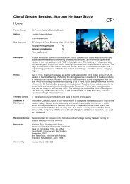
the richest mine <strong>of</strong> the <strong>Bendigo</strong> field, and a small public park <strong>of</strong>f Duncan Street set between the<br />
housing commission estate. The development <strong>of</strong> the area has not been consistent and there is no<br />
unifying urban principle to the layout and appearance <strong>of</strong> the place apart from history and the location<br />
<strong>of</strong> former mines sites. The visual character <strong>of</strong> the precinct is made up with disjointed parcels <strong>of</strong><br />
historic mine lands which are overgrown with long grass, peppercorn trees and tufts <strong>of</strong> pampas grass<br />
and regrowth ironbark trees. Views to the former mines land, the parcels <strong>of</strong> vacant Crown Land and<br />
the landscape setting <strong>of</strong> the large developments are an important feature <strong>of</strong> the precinct. The former<br />
mine sites provide a loose permeable cultural landscape, a setting for the mid 20 th century<br />
development, itself. These have been designed according to 20 th century planning ideals as pavilions<br />
in a park land. Except in this case, they have been designed serendipitously, in the middle <strong>of</strong> mine<br />
wastelands. The development includes the government low cost housing, particularly the small<br />
concrete hollow brick buildings that make up the 1949 estate and small children’s public park in the<br />
northern section <strong>of</strong> the precinct. The housing commission estate is located opposite the 1950s blond<br />
brick former Roman Catholic church now converted into a residency and is visually linked to the<br />
nearby 1950s bus shelters and concrete public benches.<br />
Statement <strong>of</strong> Significance<br />
What is Significant?<br />
The Carlisle United/Garden heritage precinct is associated with the Garden Gully line <strong>of</strong> reef mines,<br />
which were the richest mines in <strong>Bendigo</strong>. The area is particularly important in the historic<br />
development <strong>of</strong> deep lead mines <strong>of</strong> the central Victorian <strong>Bendigo</strong> goldfields. It represented the largest<br />
concentration <strong>of</strong> deep shafts anywhere in the world at the time and included the wealthiest mines,<br />
operated by the largest company mines and managed by some <strong>of</strong> the richest mining magnates <strong>of</strong> the<br />
time such as C. Ballerstedt, J.B. Watson, Joseph Bell and George Lansell. As technology and mine<br />
administration improved, so did the confidence <strong>of</strong> investors. Larger steam plants and winding engines<br />
were installed so the mines could be worked at greater depth and also control ground water inflow.<br />
The Garden Gully line <strong>of</strong> reef crosses the Ironbark Gully area in a line stretching from Barnard Street<br />
and Eaglehawk Road to Havilah Street in the north. Within this area the former mines comprises<br />
Garden Gully United, the Victory & Pandora Shaft, Victory Shaft, Bells, Old Carlisle, North Garden<br />
Gully United, Passerby, Golden Fleece, Central Garden Gully/North/Kent, Watson’s Kentish/Carlisle<br />
United Carlisle mines. The Carlisle site was continuously occupied from 1860s onwards through to<br />
1927 and is now representative <strong>of</strong> the 1890s mining revival on the Garden Gully line. The company<br />
which operated this site was the most successful in <strong>Bendigo</strong> and became <strong>Bendigo</strong>’s biggest gold<br />
producer. The mine is now known <strong>of</strong>ficially as the Carlisle North Garden Gully and Pass-by United,<br />
commonly known as the Carlisle. Its marvellous riches were owned by John Boyd Watson. The<br />
dividends paid by the Garden Gully United made it famous throughout the mining world. Garden<br />
Gully United site was continuously occupied between 1857 and 1921. Unity was continuously<br />
occupied between1870-1921. Victory and Pandora Amalgamated was continuously occupied between<br />
1857 and 1914.<br />
The goldfields became the engine room <strong>of</strong> the colony. It stimulated industry in the wider area and the<br />
economy <strong>of</strong> a nation. The quartz mining was reliant upon the manufacture, innovation and expansion<br />
Type <strong>of</strong> Place<br />
Hermes Number Heritage Place Report<br />
Page 12