HERITAGE PLACE REPORT - City of Greater Bendigo
HERITAGE PLACE REPORT - City of Greater Bendigo
HERITAGE PLACE REPORT - City of Greater Bendigo

Create successful ePaper yourself
Turn your PDF publications into a flip-book with our unique Google optimized e-Paper software.
<strong>HERITAGE</strong> <strong>PLACE</strong> <strong>REPORT</strong><br />
<strong>Greater</strong> <strong>Bendigo</strong> <strong>City</strong><br />
<strong>HERITAGE</strong> CITATION <strong>REPORT</strong><br />
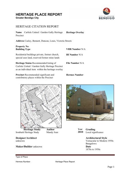
Name Carlisle United / Garden Gully Heritage<br />
Precinct<br />
Address Casley, Bennett, Duncan, Louis, Victoria Streets<br />
Property No:<br />
Building Type<br />
Residential buildings private, former church,<br />
special uses land, reserved former mine lands<br />
Heritage Status Recommended listing <strong>of</strong><br />
Carlisle United / Garden Gully Heritage Precinct<br />
as an individual item within the heritage overlay<br />
Precinct Recommended significant and<br />
contributory places within the Precinct<br />
Heritage Study<br />
Ironbark Heritage Study<br />
Designer/Architect<br />
unknown<br />
Maker/Builder unknown<br />
Type <strong>of</strong> Place<br />
Author<br />
Mandy Jean<br />
Hermes Number Heritage Place Report<br />
Heritage Overlay<br />
VHR Number N/A<br />
HI Number N/A<br />
File Number N/A<br />
Hermes Number<br />
Year<br />
2010 Grading<br />
Local significance<br />
Architectural Style<br />
Vernacular to Modern 1950s<br />
Bungalows<br />
Date<br />
1870s to 1950s<br />
Page 1
<strong>HERITAGE</strong> <strong>PLACE</strong> <strong>REPORT</strong><br />
<strong>Greater</strong> <strong>Bendigo</strong> <strong>City</strong><br />
History and Historical Context<br />
History <strong>of</strong> the Area<br />
<strong>Bendigo</strong> gold field commenced in 1851 and continued over the next 153 years through times <strong>of</strong> boom,<br />
decline, revival and stagnation. The last underground historic mine closed in 1954 with continued<br />
production locally. The <strong>Bendigo</strong> Goldfields is Australia's second largest in terms <strong>of</strong> historical<br />
production after Western Australia's Golden Mile (Boulder, Kalgoorlie). 1 It produced the largest<br />
amount <strong>of</strong> gold <strong>of</strong> any field in Eastern Australia and retains the largest evidence <strong>of</strong> its mining past<br />
within the inner city area. The history <strong>of</strong> mining shaped and created <strong>Bendigo</strong>. It left a chaotic<br />
industrial landscape which was in a state <strong>of</strong> perpetual flux with seemingly random, scattered, small<br />
and <strong>of</strong>ten very isolated settlements <strong>of</strong> people across a wide area. 2<br />
The <strong>Bendigo</strong> goldfields, about 12 kilometres wide, extend 30 kilometres from north to south. It is<br />
made up <strong>of</strong> folded beds <strong>of</strong> sedimentary rock, eroded sandstone and shale ridges which formed<br />
anticline and syncline folds that run approximately 300 metres apart in parallel formation, north-south<br />
towards Eaglehawk. The close association <strong>of</strong> all types <strong>of</strong> gold reefs with the anticline axis was<br />
recognised early in the development <strong>of</strong> the field. This early breakthrough in the predictability <strong>of</strong> ore<br />
gave mine management and investors confidence in the practice <strong>of</strong> deep shaft sinking on productive<br />
anticlines as the main exploration tool. The <strong>Bendigo</strong> Goldfield represents the largest concentration <strong>of</strong><br />
deep shafts anywhere in the world. Deep, <strong>of</strong>ten speculative, shaft sinking remained the pre-eminent<br />
exploration tool throughout the early productive life <strong>of</strong> the field (1851 to 1954). 3<br />
The majority <strong>of</strong> the <strong>Bendigo</strong> goldfields mines were worked from the 38 north-south anticline lines <strong>of</strong><br />
reef that lay from <strong>Bendigo</strong> East to Kangaroo Flat. Gullies and dry creeks cut across the ridges in a<br />
west to easterly direction, flowing into the <strong>Bendigo</strong> Creek, which flows across the gravel plains <strong>of</strong><br />
Epsom, a former shallow sea in the north, and thence into the Campaspe River, a tributary <strong>of</strong> the<br />
Murray River. The area was covered by dense Box-Ironbark forests and woodlands and was the<br />
traditional lands <strong>of</strong> the Dja Dja Wurrung Indigenous people who had managed the lands for thousands<br />
<strong>of</strong> years. In 1848 the Mount Alexander North, known later as Ravenswood pastoral lease, a<br />
government lease for grazing stock over Crown Land, was granted over this area, acquired by Stewart<br />
and Gibson. 4 With the discovery <strong>of</strong> gold and the thousands <strong>of</strong> gold diggers, who rushed to the area,<br />
the Government managed access to land through the issue <strong>of</strong> mining leases. Mining leases, pastoral<br />
leases and Indigenous native title rights co-exist over Crown Land, but at the time the Indigenous<br />
Australians were pushed to the margins <strong>of</strong> society and their rights were not considered as legitimate.<br />
In 1854 the character <strong>of</strong> the city <strong>of</strong> <strong>Bendigo</strong> (Sandhurst) changed from a collection <strong>of</strong> irregular<br />
diggings on Crown Land to a town when the area was surveyed by government surveyor, Richard<br />
Larritt. A government camp was established and the geometric grid layout <strong>of</strong> the town was laid out,<br />
streets surveyed and land auctioned for sale under Torrens Title. The primary factor governing<br />
settlement in the area was mining. It was to the outer gullies and creeks within the watershed <strong>of</strong><br />
1 <strong>Bendigo</strong> Mining for a summary <strong>of</strong> the history <strong>of</strong> mining to the present see website for <strong>Bendigo</strong> Mining<br />
http://www.bmnl.com.au/safety_environment/community_relations/gold_mining/bendigo_goldfield_history.htm<br />
2 Eaglehawk and <strong>Bendigo</strong> Heritage Study, Vol 2, Thematic History 1993<br />
3 Quoted from <strong>Bendigo</strong> Mining, op cit.<br />
4 Ravenswood Homestead, Heritage Victoria, http://vhd.heritage.vic.gov.au/places/heritage/967<br />
Type <strong>of</strong> Place<br />
Hermes Number Heritage Place Report<br />
Page 2
<strong>HERITAGE</strong> <strong>PLACE</strong> <strong>REPORT</strong><br />
<strong>Greater</strong> <strong>Bendigo</strong> <strong>City</strong><br />
<strong>Bendigo</strong> Creek where the alluvial miners first worked. 5 By mid 1852 more than 4,000 diggers were<br />
arriving each week, until over 40,000 miners had arrived in the space <strong>of</strong> a few years. Tent settlements<br />
were established in 1851-2 by ‘diggers’ intent on finding the available alluvial gold. 6 By 1861 the<br />
entire Sandhurst mining district had 41,000 people spread through a score <strong>of</strong> small mining<br />
settlements. But majority <strong>of</strong> the goldfields remained temporary and transitional in nature with<br />
haphazard settlements and roads. Other times, lack <strong>of</strong> water drove the miners on, leaving behind<br />
Crown Land that had been dug up, trees cleared, dry gullies clogged up and a wasteland created. 7 It<br />
left a legacy <strong>of</strong> large tracts <strong>of</strong> Crown Land former mine sites that encircle the city and penetrate deep<br />
within it. It is these Crown Lands and National parks in which the Dja Dja Wurrung native title<br />
interests are now recognized.<br />
With the published discovery <strong>of</strong> gold late in 1851, the name <strong>Bendigo</strong> became synonymous with gold.<br />
By the end <strong>of</strong> 1850s miners were experimenting with steam powered mills as well as crushers and<br />
open cut mining. More extensively than elsewhere, <strong>Bendigo</strong> miners used puddling machines. By mid<br />
1854 there were 1,500 machines. Attention was also turning to the mining <strong>of</strong> quartz reefs and steam<br />
powered machinery for mining was being set up as early as 1855. Supporting the miners were small<br />
foundries and accompanying this phase <strong>of</strong> mining came the building <strong>of</strong> more substantial buildings.<br />
Towards the end <strong>of</strong> the 1860s the dominance <strong>of</strong> the alluvial miner was drawing to a close and by 1868<br />
there were 4,000 alluvial miners and 3,000 quartz reef miners in <strong>Bendigo</strong>. The success <strong>of</strong> the deep<br />
shafts had grown on Hustlers Reef and Victoria Reef with associated small crushing works. The reef<br />
miners turned to steam driven crushing machines, larger mining companies were employing bigger<br />
work forces.<br />
In the early 1860s <strong>Bendigo</strong> experienced its first mining boom with the formation <strong>of</strong> hundreds <strong>of</strong><br />
companies. As technology and mine administration improved, so did the confidence <strong>of</strong> investors.<br />
Larger steam plants and winding engines were installed so the mines could be worked at greater depth<br />
and also control ground water inflow. Another mining boom was in full swing in 1871 and boosted<br />
the establishment <strong>of</strong> foundries and engineering works. In a two-year period, over one thousand new<br />
mining companies were floated with thousands <strong>of</strong> small mining leases. A frenzy <strong>of</strong> buying and selling<br />
shares occurred at the Beehive Mining Exchange. The boom soon burst, but some mines continued to<br />
operate by digging deeper into the reefs. In the early 1870s companies built up a paid work force and<br />
mining became the staple form <strong>of</strong> male employment in <strong>Bendigo</strong>. With capitalized works, the floating<br />
population <strong>of</strong> diggers diminished. Company mining altered the social structure <strong>of</strong> <strong>Bendigo</strong>. It<br />
established a new class <strong>of</strong> investors. Mining had created distinctly working class areas in town that<br />
housed the waged miners, which was separated from the wealthy socially as well as geographically. 8<br />
The boom <strong>of</strong> the late 1860s and early 1870s was over by 1873 but until the early 1890s mining<br />
remained central to the <strong>Bendigo</strong> economy. The town was untidy, disordered, brash and with<br />
conflicting land uses right in the heart <strong>of</strong> the city. 9 The early ethnic mining groups were overlaid by<br />
new social divisions <strong>of</strong> wealth and power. 10 A wider range <strong>of</strong> housing appeared during the 1870-80s.<br />
5<br />
Butler, et al, Eaglehawk and <strong>Bendigo</strong> Heritage Study, Vol 2, Thematic History.<br />
6<br />
Ballinger, Robyn, Ironbark Hill Precinct Report, <strong>City</strong> <strong>of</strong> <strong>Greater</strong> <strong>Bendigo</strong>, October 2005<br />
7<br />
Ibid<br />
8<br />
Butler, et al, Eaglehawk and <strong>Bendigo</strong> Heritage Study, Vol 2, Thematic History<br />
9 Ibid p 30<br />
10 Ibid p. 34<br />
Type <strong>of</strong> Place<br />
Hermes Number Heritage Place Report<br />
Page 3
<strong>HERITAGE</strong> <strong>PLACE</strong> <strong>REPORT</strong><br />
<strong>Greater</strong> <strong>Bendigo</strong> <strong>City</strong><br />
On some hills an elite suburbia emerged. The pattern <strong>of</strong> segregation was <strong>of</strong>ten a product <strong>of</strong><br />
topography, between high and low land. The elite found on hill tops and the cottages in low lying<br />
gullies. Public streets were planted with trees. There were a few well known mine investors and<br />
owners, who built alongside their mines such as Lazarus and Lansell.<br />
At the beginning <strong>of</strong> the 20 th century mines were still a major employer in <strong>Bendigo</strong> but the self-image<br />
<strong>of</strong> <strong>Bendigo</strong> was changing to one <strong>of</strong> a garden city with a fine climate. 11 By the 1890s architects who<br />
had reaped lucrative public contracts in the 1870s and 1880s turned to working for private clients<br />
bringing their own international style to <strong>Bendigo</strong>.<br />
Mining declined from the early years <strong>of</strong> the twentieth century. In 1917 the majority <strong>of</strong> surviving<br />
mines were amalgamated with operations ceasing in 1923. Gold mining revived in 1930s when as<br />
many as 1,500 men worked in the alluvial mining and cyaniding. The old tailings and battery sands<br />
were re-worked by about thirty cyanide plants, employing 300 men. 12 <strong>Bendigo</strong> Mines Ltd began an<br />
extensive mining program on the Nell Gwynne, Napoleon and Carshalton lines <strong>of</strong> reef. Mines such as<br />
Royal George, Moonta and Central Nell Gwynne operated throughout this period but with little<br />
success. In contrast, the Central Deborah Mine started production in 1939 and continued until 1954. 13<br />
The capitalised mining boom rose and fell in a cycle like that <strong>of</strong> the digging rushes <strong>of</strong> the 1850s.A<br />
sudden find attracted a rush <strong>of</strong> investors who put money into new leases. Many mines sunk proved<br />
uneconomic, investors withdrew, returned after rumours <strong>of</strong> new wealth and over the decades a small<br />
number <strong>of</strong> pr<strong>of</strong>itable companies survived from hundreds formed in the excitement <strong>of</strong> the richest<br />
discovers. But by that time the traditional manufacturing industries <strong>of</strong> the 19 th century such as black<br />
smithing, brick making, tanners, coach building, confectioneries, cordial manufacturers, flour milling<br />
and foundries had also declined. Increasingly, local primary industries converted to manufacturing<br />
foodstuff to marketable commodities. Growth occurred in motor vehicles, electrical engineering,<br />
housing construction and railway workshop trades. 14 <strong>Bendigo</strong> began to present itself as the<br />
Sanatorium <strong>of</strong> the South a pleasant, healthy resort. 15<br />
History <strong>of</strong> Long Gully and Ironbark Gully<br />
Shaping Victoria’s Environment: The Natural Landscape<br />
The cultural landscape <strong>of</strong> Long Gully and Ironbark Gully contains some <strong>of</strong> the richest gold bearing<br />
reefs on the <strong>Bendigo</strong> goldfields and had the highest concentration <strong>of</strong> quartz mines in <strong>Bendigo</strong>. Eleven<br />
gold bearing lines <strong>of</strong> reef spread across the area. These include, starting from the head <strong>of</strong> Long Gully<br />
at Specimen Hill in the west and running parallel eastwards, Thistle, Lancashire, Napoleon, Nell<br />
Gywnne, New Chum, Sheepshead, Garden Gully, the smaller Paddy Gully’s, Derby’s, Miller’s to<br />
11 Ibid p.48<br />
12 Cusack, F. <strong>Bendigo</strong> a history, revised edition, 2002, Lerk & McClure, 2002, p.244<br />
13 Eaglehawk and <strong>Bendigo</strong> Heritage Study Significant Mining Areas and Sites Repo, Vol 3 pp.123-235<br />
14 Ibid Vol 4 p.1 Appendix 1<br />
15 Ibid p. 49<br />
Type <strong>of</strong> Place<br />
Hermes Number Heritage Place Report<br />
Page 4
<strong>HERITAGE</strong> <strong>PLACE</strong> <strong>REPORT</strong><br />
<strong>Greater</strong> <strong>Bendigo</strong> <strong>City</strong><br />
Hustlers line <strong>of</strong> reef in the extreme east, the point where Ironbark Gully and Long Gully merge<br />
together before entering <strong>Bendigo</strong> Creek. 16<br />
The thickly forested gullies <strong>of</strong> Ironbark Gully and Long Gully were well known to alluvial miners<br />
from the early 1850s. Gold finds by Shanahan & Glen & Thompson in 1852 paralleled with many<br />
others across the <strong>Bendigo</strong> field gullies. 17 At Ironbark, J. Harris & party discovered the famous<br />
Hustler’s Reef in 1853 between Iron Bark and Commissioner’s gullies. 18 One story <strong>of</strong> the earliest<br />
reefers in the area was <strong>of</strong> two boys, who discovered the Victoria Reef near Ironbark Gully and sold<br />
their claim to Christopher Ballerstedt. The ‘eccentric German’ Ballerstedt, an old soldier <strong>of</strong> Blucher’s<br />
army, with his son Theodore, brought a puddler for £60 after seeing specimens on the surface at the<br />
end <strong>of</strong> 1853. He soon had a half-ton <strong>of</strong> gold at the <strong>Bendigo</strong> treasury. 19 The Hustler’s line was<br />
discovered in 1853 by an African American named Jonathan Harris, who found gold on the northern<br />
slope <strong>of</strong> Mac’s or Hustler’s Hill in the lease held later by the Great Extended Hustler’s Company. In<br />
1854, J. Hustler, Jonathan Latham and John Watson bought Harris’s ground (12 foot by 12 foot), and<br />
purchased several <strong>of</strong> the adjacent claims. These, by amalgamation, became the famous Great<br />
Extended Hustler’s mine. Rich gold started at the surface - the first crushing yielded 26 ounces to the<br />
ton - and was worked down the northern slope <strong>of</strong> the hill to Ironbark Gully.<br />
The area became one <strong>of</strong> the earliest quartz reef mines with early but unsuccessful open cut mines<br />
replaced later by more successful deep shafts that operated from 1861. The mines at first were small<br />
and worked by local miners who lived in the area. Large scale mining became more feasible than<br />
small claims which were amalgamated. By 1871, a number <strong>of</strong> mines were operating in the area<br />
including the Victory and Pandora. The Eastern Victorian Consols mine (associated with Victoria<br />
Hill) was sunk on the Sheepshead Reef in 1865 on Rae’s Hill (Ironbark Hill) in 1865 20 and was still in<br />
operation as the Ironbark South mine in 1940. ‘The number <strong>of</strong> shafts sunk on the reef from its outcrop<br />
to the Ironbark Gully gave it more the appearance <strong>of</strong> shallow alluvial mining than <strong>of</strong> vein mining,’<br />
says William Nicholas in one <strong>of</strong> his letters on ‘The Golden Quartz Reefs <strong>of</strong> Australia’, contributed to<br />
the London Mining Journal in 1884. 21 Local stories tell <strong>of</strong> the rush to clear the local Ironbark forest<br />
for use in the mines. The name <strong>of</strong> Ironbark and the iron like characteristics <strong>of</strong> the tree have become a<br />
symbol <strong>of</strong> history <strong>of</strong> the place. 22<br />
Building Victoria’s Industries and Workforce: Mining labour force and technological achievements<br />
By the late 1860s the successful quartz reef mining industry necessitated sinking much deeper shafts<br />
making production dependent upon highly capitalised mines with massive machinery and a large<br />
work force. The earliest successful ore crusher was Ballerstedt’s works in Long Gully, where he<br />
employed a large workforce. Shares in mines on Victoria Hill and in Garden Gully line <strong>of</strong> reef were<br />
later purchased by George Lansell, who became a leader in quartz mining in <strong>Bendigo</strong>. The New Chum<br />
and Nell Gwynne lines <strong>of</strong> reef are central elements to the Victoria Hill and include Adventure &<br />
16<br />
Birrell, R.W. and James A. Lerk, <strong>Bendigo</strong>’s Gold Story, pub Lerk 2001 p 4<br />
17<br />
Ibid Vol 3 p 23<br />
18<br />
Mining Chronology Vol 3<br />
19<br />
Age, 11 Jan 1856, in Gazetteer <strong>of</strong> Historic Mining Sites, Heritage Victoria<br />
20<br />
A. V. Palmer, Gold Mines <strong>of</strong> <strong>Bendigo</strong>, Book Two, p. 52; Mines Department map <strong>Bendigo</strong> 1923, reissued 1936<br />
21<br />
Gazetteer <strong>of</strong> Historic Mining Sites, Heritage Victoria<br />
22<br />
See press clippings <strong>of</strong> the 1998 ‘The Save Ironbark Campaign’ supported by over 1000 local community<br />
members.<br />
Type <strong>of</strong> Place<br />
Hermes Number Heritage Place Report<br />
Page 5
<strong>HERITAGE</strong> <strong>PLACE</strong> <strong>REPORT</strong><br />
<strong>Greater</strong> <strong>Bendigo</strong> <strong>City</strong><br />
Advance, Ballerstedt, Central Nell Gwynne, Great Central Victoria, Lansell’s 180, New Chum<br />
Syncline, Old Chum, William Rae and Victoria Quartz mines. 23 William Rae found large quantities <strong>of</strong><br />
gold from his open cut mine on Victoria Hill, where he later built a 35 head battery in Happy Valley.<br />
24 The reef miners, Carl Roeder and Carl Mueller, were also prominent figures in Happy Valley Road,<br />
Victoria Hill. The Carshalton, Lancashire, Napoleon and Nell Gwynne lines <strong>of</strong> reef were mined by the<br />
mining magnate, Barnet Lazarus. The mines were located near Harveytown comprising the Prince <strong>of</strong><br />
Wales and Saxby group and had connections to the mines around Lazarus and Harvey Streets in Long<br />
Gully. Well known investors were B.D. Lazarus and George Lansell, both <strong>of</strong> whom massed a fortune.<br />
Beneath these men, was an echelon <strong>of</strong> mining investors who speculated successful on mines as well as<br />
taking part in other aspects <strong>of</strong> commercial life such as for example Darnton Watson, who lived in<br />
Ironbark, a dealer in hay and corn but made more money from mining as well as Truscott. 25<br />
For years mines on the Garden Gully line <strong>of</strong> reef and Hustler’s line <strong>of</strong> reef proved exceedingly rich<br />
investments. Mines that operated in this area include the Victory & Pandora Shaft, Victory and<br />
Pandora Amalgamated (which was continuously occupied between 1857 and 1914); Victory Shaft,<br />
Bells, Old Carlisle, North Garden Gully United, Pass-by and Unity (which was continuously occupied<br />
between1870-1912); Garden Gully United site (which was continuously occupied between 1857 and<br />
1921). Other mining operations included, Golden Fleece, Central Garden Gully/North Kent, Watson’s<br />
Kentish/Carlisle United and Carlisle site (which were continuously occupied from 1860s onwards<br />
through to 1927 and is now representative <strong>of</strong> the 1890s mining revival on the Garden Gully line). J.B.<br />
Watson was credited with taking 13 tons <strong>of</strong> gold on the Garden Gully line <strong>of</strong> reef leases which he<br />
consolidated into the Kentish Mine. He amassed a fortune and became one <strong>of</strong> the richest men in the<br />
colony. 26 Other mining investors associated with the area include, Barnet Lazarus, George Lansell,<br />
William Johnson, Joseph Bell, W. & A. Hunter, Schmidt and Barker. Henry Koch’s Long Gully<br />
pyrites treatment works opened in 1869 and he later pioneered the use <strong>of</strong> the diamond drill in the<br />
Koch’s Long Gully Pioneer Gold Mine. Many small black smithies and large iron foundries serviced<br />
the local mines. The earliest foundry was Wellington Ironbark foundry-Swalling Briggs & Delaney<br />
engineers now Central Foundry and nearby W. Gradling blacksmith. 27 In Long Gully to the north on<br />
Eaglehawk Road was Horsfield, engineers and Dennis, blacksmiths.<br />
Transforming the land: Mining Wastelands<br />
The depths <strong>of</strong> mineralisation at <strong>Bendigo</strong> placed some <strong>of</strong> the field at the leading edge <strong>of</strong> mining<br />
technology with shafts being the deepest in the world at that time. 28 Throughout the mining history <strong>of</strong><br />
the <strong>Bendigo</strong> goldfields in excess <strong>of</strong> 5,000 shafts were sunk (90 km <strong>of</strong> shaft sinking in total). Despite<br />
this amount <strong>of</strong> shaft sinking the vast majority <strong>of</strong> the field is tested to depths <strong>of</strong> less than 200 m due to<br />
the physical and technical constraints on mining and exploration in the 19th Century. 29 The<br />
combination <strong>of</strong> small leases and the great depths <strong>of</strong> mineralisation created problems in raising capital,<br />
limited the utilisation <strong>of</strong> expensive assets, reduced the chances <strong>of</strong> developing economies <strong>of</strong> scale and<br />
limited geological knowledge to a small fraction <strong>of</strong> the whole field. Massive problems were caused by<br />
23 Ibid Vol 2 p. 34<br />
24 Ellis, G. E., A Brief History and Reminiscence <strong>of</strong> Long Gully, <strong>City</strong> <strong>of</strong> <strong>Greater</strong> <strong>Bendigo</strong>, 2000, p 45<br />
25 Ibid p 32<br />
26 Ibid p 31<br />
27 Eaglehawk and <strong>Bendigo</strong> Thematic History Vol 2 p 24<br />
28 Ibid<br />
29 <strong>Bendigo</strong> Mining history http://www.bmnl.com.au/about_us/goldfield_history.htm<br />
Type <strong>of</strong> Place<br />
Hermes Number Heritage Place Report<br />
Page 6
<strong>HERITAGE</strong> <strong>PLACE</strong> <strong>REPORT</strong><br />
<strong>Greater</strong> <strong>Bendigo</strong> <strong>City</strong><br />
mining with resultant sludge, silt and flooding contaminating the water supplies. Lack <strong>of</strong> water, severe<br />
drought, wind blown contaminated dust caused severe outbreak <strong>of</strong> diseases, blindness, cholera,<br />
typhoid which was a major problem. 30<br />
The disused mine sites became contaminated industrial wastelands creating a physical barrier that<br />
separated early residential areas into small isolated pockets <strong>of</strong> scattered miners’ cottages from the rest<br />
<strong>of</strong> the growing suburbs <strong>of</strong> <strong>Bendigo</strong>. After the major decline in mining in the early to mid 2 0th century,<br />
these large areas <strong>of</strong> mining wastelands <strong>of</strong> sand heaps, old sludge dams and cyanide tailing dams<br />
remained un-developed, ‘a dry slum’. 31 These factors resulted in the creation <strong>of</strong> a poor working class<br />
suburb that remained under resourced and largely intact until the mid to late 20 th century. Attempts at<br />
dust mitigation by planting <strong>of</strong> peppercorn trees was minimal, the land remained a source <strong>of</strong> dust and<br />
contamination until the 1950s and 1960s when some parcels <strong>of</strong> land were cleaned up for low cost<br />
housing and state government commission housing. 32<br />
Peopling Victoria’s Places And Landscapes: Transnational Migration<br />
Ironbark was noted for its high percentage <strong>of</strong> early residents, who were skilled Cornish and German<br />
miners. They came in large affiliated family groups from Europe and America and from Burra Burra,<br />
Kapunda and Moonta in South Australia as well as California. The early German miners, who<br />
established early mining claims are associated with Ironbark Hill settlement. They came with<br />
skills and experience. They frequently formed mining partnerships amongst themselves such as<br />
and included C. Ballerstedt and his son, Carl Roeder (Harz miner), Carl Mueller, Carl Schier<br />
(Harz miner), C. Schroeder, F. Schilling, Carl Weber, H. Waswo and others like the Pole,<br />
Barnet Lazarus who mined nearby on Nell Gwynne, Napoleon and Lanchashire line <strong>of</strong> reef.<br />
The skills <strong>of</strong> the German quartz miners and speculators had a significant influence on the<br />
development <strong>of</strong> quartz mining in <strong>Bendigo</strong>. They were noted for their introduction <strong>of</strong> German mining<br />
equipment and skill in underground tunneling, examples <strong>of</strong> which have World Heritage listing in the<br />
Harz mining area <strong>of</strong> Germany, from where many <strong>Bendigo</strong> German miners came. German mining<br />
development and machinery has had a continuing influence on mining in Australia. Unlike the<br />
Cornish miners in the area, the majority <strong>of</strong> the German miners left as soon as they could and<br />
established orchards, viticulture and other agricultural businesses.<br />
Another large ethnic group in the area was the Chinese, numbering 400-500 in 1868. There were<br />
several large Chinese villages in the <strong>Bendigo</strong> district <strong>of</strong> which one was located in Long Gully, near<br />
the junction with Sparrowhawk Gully. 33 Chinese miners worked the mullock heaps and discarded ore<br />
bodies in Long Gully and Ironbark Gully, in spite <strong>of</strong> concerted political agitation to discourage them.<br />
It was John Quick, former resident <strong>of</strong> Ironbark, who introduced the first bill into Parliament in 1888<br />
30<br />
Butler, et al, Eaglehawk and <strong>Bendigo</strong> Heritage Study, Vol 2, Thematic History<br />
31<br />
Ellis, G. E., A Brief History and Reminiscence <strong>of</strong> Long Gully, <strong>City</strong> <strong>of</strong> <strong>Greater</strong> <strong>Bendigo</strong>, 2000, p 47.<br />
32<br />
Ibid .<br />
33<br />
The largest historic Chinese settlement was located in Bridge Street to Finn and Thunder Streets, an area<br />
which was once regarded as part <strong>of</strong> Ironbark.<br />
Type <strong>of</strong> Place<br />
Hermes Number Heritage Place Report<br />
Page 7
<strong>HERITAGE</strong> <strong>PLACE</strong> <strong>REPORT</strong><br />
<strong>Greater</strong> <strong>Bendigo</strong> <strong>City</strong><br />
for the disenfranchisement <strong>of</strong> Chinese holding a Miner’s Right. 34 Chinese herbalists and shop keepers<br />
continued to operate businesses in Ironbark well into the 20 th century. 35<br />
Cornish mining technology was essential in Victoria mining in the years after 1860 and the influence<br />
<strong>of</strong> the Cornish permeated into other aspects <strong>of</strong> social and cultural life in the Victorian central gold<br />
fields. 36 Cornish mining practice and managers became prominent in the quartz mines <strong>of</strong> Victoria. It<br />
was the Cornishman's traditional skills <strong>of</strong> shaft sinking and stoping and the tribute system, which was<br />
well known in Cornwall that were in immediate demand. This historical process relates the area and<br />
Victoria to an international context that had its beginning with the collapse in the summer <strong>of</strong> 1866 <strong>of</strong><br />
the Cornish copper mining industry. It resulted in a massive exodus <strong>of</strong> Cornish miners and their<br />
families, who introduced their mining labour practices, tributing system, technology and culture to<br />
new areas around the world.<br />
The Carlisle United/Garden Gully heritage precinct is particularly associated with John Boyd Watson,<br />
a mining magnate and investor, who was born in September 1828 at Paisley, Scotland. 37 His family<br />
settled at Windsor near Sydney where Watson became a currier (a person who dresses and colours<br />
leather after it is tanned). He moved to Sydney but in 1850 left for the Californian diggings. On his<br />
return, he set <strong>of</strong>f for the Victorian gold fields, and in late 1852 reached <strong>Bendigo</strong> Creek. He was quick<br />
to realize the potential richness <strong>of</strong> the <strong>Bendigo</strong> reefs, and was amongst the first to erect a crushing<br />
battery. Watson's initial quartz-mining venture was the Old Chum Claim on New Chum Hill. Next,<br />
with a partner he bought a claim in Paddy's Gully. With others he floated the Cornish United Co. and<br />
in the late 1860s secured an interest in the adjoining Golden Fleece, Kent and Garden Gully claims,<br />
later buying and amalgamating them under one lease as the Kentish Mine, which he owned until<br />
1889. It produced huge amounts <strong>of</strong> gold in 1871-80, one reef alone yielding about thirteen tons <strong>of</strong><br />
gold valued at some £1,500,000. He owned much property in Sandhurst and his extensive Melbourne<br />
holdings included the freehold <strong>of</strong> some <strong>of</strong> the most valuable inner-city properties. He was a founder,<br />
director and principal shareholder <strong>of</strong> the Federal Bank and a large shareholder in the Melbourne<br />
Tramways Co., the Deniliquin and Moama Railway Co. and a Sydney steamship company. He had<br />
mining and pastoral interests in Queensland, owned wharves in Sydney and in 1879, with a group <strong>of</strong><br />
Sandhurst investors; he launched the Sydney Daily Telegraph. In the history <strong>of</strong> quartz mining at<br />
<strong>Bendigo</strong>, George Lansell, in the development <strong>of</strong> deep quartz mining a handful <strong>of</strong> other speculators —<br />
such as Ernest Mueller, John Boyd Watson, Edward Isaac Dyason, Barnett Lazarus, Carl Roeder and<br />
the Hunter brothers — reaped substantial rewards from the Ironbark quartz reefs and mines located<br />
along the Garden Gully line <strong>of</strong> reef. 38<br />
34<br />
<strong>Bendigo</strong> Chinese Association Museum, publication Chinese Footsteps, 2000 p. 36<br />
35<br />
Ibid. p. 40 Quinn store in Milroy Street, also evidence from <strong>Bendigo</strong> rates books.<br />
36 nd<br />
Fahey, Charles, From St Just to St Just Point, Cornish migration to Victoria, Cornish Studies, 2 Series Vol<br />
15, University <strong>of</strong> Exeter, UK pp117-140 for survey <strong>of</strong> Cornish migration to <strong>Bendigo</strong> and Ironbark.<br />
37<br />
On-line Australian Dictionary <strong>of</strong> Biography provided most <strong>of</strong> the information on John Boyd Watson,<br />
summarised in Australian Post mining stamps<br />
38<br />
Charles Fahey For the wealth <strong>of</strong> <strong>Bendigo</strong>nians in the last two decades <strong>of</strong> the nineteenth century see J. C.<br />
Fahey, ‘Wealth and Mobility in <strong>Bendigo</strong> and Northern Victoria 1879–1901, Unpublished Ph.D., Melbourne<br />
University, 1981<br />
Type <strong>of</strong> Place<br />
Hermes Number Heritage Place Report<br />
Page 8
<strong>HERITAGE</strong> <strong>PLACE</strong> <strong>REPORT</strong><br />
<strong>Greater</strong> <strong>Bendigo</strong> <strong>City</strong><br />
Governing Victorians: Government and Surveillance<br />
The cultural landscape <strong>of</strong> Long Gully/Ironbark area <strong>of</strong> <strong>Bendigo</strong> clearly demonstrates the impact <strong>of</strong> the<br />
particular mining leasing system associated with deep quartz mining and the way in which it was<br />
administered and interpreted by the Mining Board in <strong>Bendigo</strong>. An important consequence <strong>of</strong> this was<br />
the establishment <strong>of</strong> large company mining in the area, which led to the highest concentration <strong>of</strong><br />
working miners living within one location in <strong>Bendigo</strong>. But despite the numbers and size <strong>of</strong> mining<br />
companies operating in the area, lack <strong>of</strong> capital meant that operations were <strong>of</strong>ten intermittent,<br />
necessitating miners to work in several different mines each year. This in turn led to what became a<br />
chronic oversupply <strong>of</strong> local miners as the mines stopped operating whenever they were not paying and<br />
miners were laid <strong>of</strong>f. To avoid making calls on their shareholders to raise capital the mine companies<br />
and owners let in the tributors. The introduction <strong>of</strong> tributing, was based on an ancient Cornish mining<br />
tradition, whereby miners formed tribute parties, self employed groups, that leased a mine or part <strong>of</strong> it<br />
from a larger company in order to receive a percentage <strong>of</strong> the gold mined. They were contracted to<br />
pay for haulage and crushing ore, timber for propping new underground workings and use <strong>of</strong> tools,<br />
despite the <strong>of</strong>ten irregular or non existent returns. The labour system was highly inefficient and<br />
subject to abuse by mine owners. The practice was hierarchical, hereditary and in some view<br />
rudimentary. Despite this, some <strong>of</strong> the biggest mining companies such as those owned by Lansell,<br />
would only employ Cornish miners because <strong>of</strong> the favourable options for tributing, when operations<br />
in the mines slowed due to lack <strong>of</strong> finance or equipment. This symbiotic relationship between mine<br />
owner, company and workers meant that union agitation for better working conditions was low in<br />
comparison with other fields.<br />
The operations <strong>of</strong> drilling, blasting and shovelling created excessive dust, which together with poorly<br />
ventilated workings, led to very high mortality rates amongst the miners in the Ironbark and Long<br />
gully areas. Deaths by phthisis and tuberculosis in <strong>Bendigo</strong> were the highest in the state. 39 Miners<br />
unions were formed in 1870s. Industrial conflicts occurred in 1872, 74 and 79 by which time<br />
organized working class had spread to those employed in bakeries and other factories.<br />
Building Towns, Cities and the Garden State: Buildings Towns and Cities<br />
When quartz mining expanded into these gullies, they took on the character <strong>of</strong> small villages. The<br />
quartz mining town functioned with a labour force living close to the mine head. The Ironbark Hill<br />
area was a former working class mining residential area associated with the Garden Gully line <strong>of</strong> reef,<br />
a wide strip <strong>of</strong> Crown Land, formerly containing extensive mining works, shaft spill dams and<br />
mullock heaps, moving north from Ironbark creek. The working class miners cottages associated with<br />
these deep quartz mining operations could be regarded as one <strong>of</strong> the first mining company towns <strong>of</strong><br />
Australia. The buildings were built by miners, themselves, on Miners’ Residency Areas, which was<br />
usually subject to the approval by the local mine owner as well as the Mine Warden.<br />
For the first 25 years or so, these cottages were occupied almost exclusively by miners who worked<br />
locally. Their homes were connected by a system <strong>of</strong> informal pathways to the mines, battery stamps,<br />
ore crushing and pyrite refining complexes where they worked. The framework <strong>of</strong> this early<br />
settlement remains largely intact. Only the original quarter acre blocks, the Miners Residency Areas,<br />
have subsequently been subdivided and developed with in-fill housing <strong>of</strong> the 1920s and 1950s/60s.<br />
Other areas include the Housing Commission homes built on the reclaimed former Carlisle spill dam<br />
39 Dingle, Tony, The Victorians, Setting, Farifax, Syme & Weldon & Ass, 1984, p 99<br />
Type <strong>of</strong> Place<br />
Hermes Number Heritage Place Report<br />
Page 9
<strong>HERITAGE</strong> <strong>PLACE</strong> <strong>REPORT</strong><br />
<strong>Greater</strong> <strong>Bendigo</strong> <strong>City</strong><br />
area between Duncan, Bennett, Casley and Louis Streets, and the 1950/60s housing subdivisions<br />
facing Peters Street, on the site <strong>of</strong> the former Kent mine.<br />
Bibliography<br />
References:<br />
Primary Resources<br />
Gazetteer <strong>of</strong> Historic Mining Sites, Heritage Victoria<br />
George Mackay, editor, Annals <strong>of</strong> <strong>Bendigo</strong> Volume Two 1868-1891, p.239<br />
Ironbark Hill Sandhurst, PROV, VPRS 795/P0, unit 1985, item 323<br />
Index to Residence Areas, PROV, VPRS 149/P0, unit 1<br />
PROV Agency VA 508, Housing Commission <strong>of</strong> Victoria<br />
Register <strong>of</strong> Residence Area 1876-1885, Sandhurst District Waranga North Division, PROV, VPRS/P0, unit 1<br />
VA 4862 Sandhurst - VPRS 16267 Rate Books 1856-1958, <strong>Bendigo</strong> Regional Archives Centre (BRAC).<br />
Maps<br />
<strong>Bendigo</strong> Sewerage Authority Detail Plan No. 94, 15 April, 1930<br />
<strong>City</strong> <strong>of</strong> <strong>Greater</strong> <strong>Bendigo</strong> Planning Scheme maps 2005<br />
<strong>City</strong> <strong>of</strong> Sandhurst Plan Showing Roads and Streets to be Proclaimed 1871, Roll Plan 74, Map Collection, SLV<br />
Hart, G. W., Plan <strong>of</strong> Mining Tenements on the Garden Gully Johnsons and Other Reefs Sandhurst, in<br />
John Neill Macartney, The <strong>Bendigo</strong> Goldfields Registry, Melbourne, Charles F. Maxwell, 1871<br />
Mines Department map <strong>Bendigo</strong> 1923, reissued 1936<br />
Parish <strong>of</strong> Sandhurst map 1961<br />
Secondary Sources<br />
Ballinger, Robyn, History <strong>of</strong> Ironbark Hill 2005, <strong>City</strong> <strong>of</strong> <strong>Greater</strong> <strong>Bendigo</strong><br />
<strong>Bendigo</strong> Advertiser, 6 September 2004<br />
<strong>Bendigo</strong> Library, A Vision Splendid, image database<br />
<strong>Bendigo</strong> Mining for a summary <strong>of</strong> the history <strong>of</strong> mining see website for <strong>Bendigo</strong> Mining<br />
http://www.bmnl.com.au/safety_environment/community_relations/gold_mining/bendigo_goldfield_history.htm<br />
Borrie, W, Italians and Germans in Australia: A Study <strong>of</strong> Assimilation, Australian Nation University, Melbourne, n.d.<br />
Caire, N. J., Views <strong>of</strong> <strong>Bendigo</strong>, <strong>Bendigo</strong>, <strong>Bendigo</strong> Trust, c1979<br />
Cusack, Frank, <strong>Bendigo</strong> the German Chapter, German Heritage Society, 1998<br />
Cusack, Frank, <strong>Bendigo</strong>: A History. Lerk & McClure, <strong>Bendigo</strong>, 2002 (rev. ed.)<br />
Davison, Graeme, John Hirst and Stuart MacIntyre, The Oxford Companion to Australian History, Melbourne,<br />
Oxford University Press, 1999<br />
Dingle, Tony, ‘Miners and their Cottages’, Nothing But Gold Conference, October 2001, <strong>Bendigo</strong><br />
Dingle, Tony , Miner’s Cottages, in Australian Economic History Review, Blackwell Publishing, 2010<br />
Eaglehawk and <strong>Bendigo</strong> Heritage Study, 1993, Butler, Significant Mining Areas and Sites Report, Vol 3<br />
pp.123-235<br />
Ellis, George A., A Brief History and Reminiscence <strong>of</strong> Long Gully, <strong>Bendigo</strong>, George A. Ellis, 2000<br />
Gazetteer <strong>of</strong> Historic Mining Sites, Heritage Victoria http://www.heritage.vic.gov.au/page.asp?ID=124<br />
Fahey, Charles, From St Just to St Just Point, Cornish migration to Victoria, Cornish Studies, 2 nd Series Vol 15,<br />
University <strong>of</strong> Exeter, UK pp 117-140 for survey <strong>of</strong> Cornish migration to <strong>Bendigo</strong> and IronbarkIbid based on<br />
Rates Book information 1865-1920<br />
Fahey, Charles, Senior Lecturer in History, La Trobe University <strong>Bendigo</strong>, personal communication<br />
Type <strong>of</strong> Place<br />
Hermes Number Heritage Place Report<br />
Page 10
<strong>HERITAGE</strong> <strong>PLACE</strong> <strong>REPORT</strong><br />
<strong>Greater</strong> <strong>Bendigo</strong> <strong>City</strong><br />
Fahey, Charles, Cornish Miner’s in <strong>Bendigo</strong>: An Examination <strong>of</strong> their Standard <strong>of</strong> Living, Department <strong>of</strong> History Monash<br />
University n.d.<br />
Hopkins, Ruth, Where no Cousin Jack?, <strong>Bendigo</strong> Bicentenniel Committee, <strong>Bendigo</strong> 1988<br />
Hopkins, Ruth, Cousin Jack, man for the times:” A History <strong>of</strong> the Cornish People in Victoria, Ruth Hopkins, <strong>Bendigo</strong> 1994<br />
James Lerk and Carol Holdsworth pers. communication regarding the work <strong>of</strong> the Chinese mine contractors on<br />
the tailings<br />
Lerk, James, personal communication<br />
Lerk, James, ‘Discover <strong>Bendigo</strong>: Ironbark Hill School <strong>of</strong> John Rae’, <strong>Bendigo</strong> Weekly, 21.1.2000<br />
Mackay, George, History <strong>of</strong> <strong>Bendigo</strong>. Lerk & McClure, <strong>Bendigo</strong>, 2000 (rev. ed.)<br />
Mackay, George, editor, Annals <strong>of</strong> <strong>Bendigo</strong> Volume Two 1868-1920<br />
PROV, VPRS 795/P0, unit 1985 323 Ironbark Hill Sandhurst; George A. Ellis, A Brief History and<br />
Reminiscence <strong>of</strong> Long Gully, p. 22<br />
Palmer, A.V., Gold Mines <strong>of</strong> <strong>Bendigo</strong>, Book Two, Hawthorn, Craftsman Press, 1979<br />
Ravenswood Homestead, Heritage Victoria, http://vhd.heritage.vic.gov.au/places/heritage/967<br />
Relevant Historical Australian Themes<br />
• Shaping Victoria’s Environment: The Natural Landscape<br />
• Peopling Victoria’s Places And Landscapes: Transnational Migration<br />
• Governing Victorians: Government and Surveillance<br />
• Transforming the land: Mining Wastelands<br />
• Building Victoria’s Industries And Workforce: Mining labour force and technological<br />
achievements<br />
• Building Towns, Cities And The Garden State: Buildings towns and cities<br />
• Building Communities: New roads to self improvement<br />
Description <strong>of</strong> the Precinct<br />
The boundaries <strong>of</strong> the precinct area reflect the extent <strong>of</strong> the workings <strong>of</strong> the former mines inclusive <strong>of</strong><br />
Victory & Pandora Shaft, Victory Shaft, Bells, Old Carlisle, North Garden Gully United, Pass-by and<br />
Unity Garden Gully United site Golden Fleece, Central Garden Gully/North Kent, Watson’s<br />
Kentish/Carlisle United and Carlisle mine site, which were continuously occupied from 1857s through<br />
to 1927. With a few exceptions <strong>of</strong> miners’ cottages, the whole area was dug up, turned over,<br />
excavated, used as storage for tailings, wood and ore bodies prior to cartage, drainage channels, small<br />
sludge dams, shaft pits and entries, pump houses, chimneys, sheds and batteries. At the closure <strong>of</strong> the<br />
mines in 1930s the area was left a wasteland. There was no regeneration <strong>of</strong> the area, the soils were destable<br />
and blew away as dust and washed away as sludge. It was only after the Second World War<br />
that there was a consistent effort to fill in mine shafts, dismantled the massive brick chimneys and<br />
clean up ready for large government residential development for the disadvantaged such as the public<br />
housing development (1949) between Duncan, Bennett and Louis Street, age care facilities at the<br />
corner <strong>of</strong> Bennet and Buckley Streets, the site <strong>of</strong> low cost housing services and development <strong>of</strong> the<br />
Scope (Vic) Ltd. formerly the Spastic Society <strong>of</strong> Victoria (1948) in Bennett and Victoria Streets,<br />
which were constructed on the most accessible <strong>of</strong> mines sites in areas <strong>of</strong> the least numbers <strong>of</strong> shafts.<br />
The former mine lands remain as important areas <strong>of</strong> public open space and include the highest<br />
vantage point located <strong>of</strong>f Bell and Roeder Street, an important look out site with panoramic views<br />
along the Garden Gully line <strong>of</strong> reef, Victoria Hill and Hustlers Hill; the former site <strong>of</strong> Kent mine once<br />
Type <strong>of</strong> Place<br />
Hermes Number Heritage Place Report<br />
Page 11
<strong>HERITAGE</strong> <strong>PLACE</strong> <strong>REPORT</strong><br />
<strong>Greater</strong> <strong>Bendigo</strong> <strong>City</strong><br />
the richest mine <strong>of</strong> the <strong>Bendigo</strong> field, and a small public park <strong>of</strong>f Duncan Street set between the<br />
housing commission estate. The development <strong>of</strong> the area has not been consistent and there is no<br />
unifying urban principle to the layout and appearance <strong>of</strong> the place apart from history and the location<br />
<strong>of</strong> former mines sites. The visual character <strong>of</strong> the precinct is made up with disjointed parcels <strong>of</strong><br />
historic mine lands which are overgrown with long grass, peppercorn trees and tufts <strong>of</strong> pampas grass<br />
and regrowth ironbark trees. Views to the former mines land, the parcels <strong>of</strong> vacant Crown Land and<br />
the landscape setting <strong>of</strong> the large developments are an important feature <strong>of</strong> the precinct. The former<br />
mine sites provide a loose permeable cultural landscape, a setting for the mid 20 th century<br />
development, itself. These have been designed according to 20 th century planning ideals as pavilions<br />
in a park land. Except in this case, they have been designed serendipitously, in the middle <strong>of</strong> mine<br />
wastelands. The development includes the government low cost housing, particularly the small<br />
concrete hollow brick buildings that make up the 1949 estate and small children’s public park in the<br />
northern section <strong>of</strong> the precinct. The housing commission estate is located opposite the 1950s blond<br />
brick former Roman Catholic church now converted into a residency and is visually linked to the<br />
nearby 1950s bus shelters and concrete public benches.<br />
Statement <strong>of</strong> Significance<br />
What is Significant?<br />
The Carlisle United/Garden heritage precinct is associated with the Garden Gully line <strong>of</strong> reef mines,<br />
which were the richest mines in <strong>Bendigo</strong>. The area is particularly important in the historic<br />
development <strong>of</strong> deep lead mines <strong>of</strong> the central Victorian <strong>Bendigo</strong> goldfields. It represented the largest<br />
concentration <strong>of</strong> deep shafts anywhere in the world at the time and included the wealthiest mines,<br />
operated by the largest company mines and managed by some <strong>of</strong> the richest mining magnates <strong>of</strong> the<br />
time such as C. Ballerstedt, J.B. Watson, Joseph Bell and George Lansell. As technology and mine<br />
administration improved, so did the confidence <strong>of</strong> investors. Larger steam plants and winding engines<br />
were installed so the mines could be worked at greater depth and also control ground water inflow.<br />
The Garden Gully line <strong>of</strong> reef crosses the Ironbark Gully area in a line stretching from Barnard Street<br />
and Eaglehawk Road to Havilah Street in the north. Within this area the former mines comprises<br />
Garden Gully United, the Victory & Pandora Shaft, Victory Shaft, Bells, Old Carlisle, North Garden<br />
Gully United, Passerby, Golden Fleece, Central Garden Gully/North/Kent, Watson’s Kentish/Carlisle<br />
United Carlisle mines. The Carlisle site was continuously occupied from 1860s onwards through to<br />
1927 and is now representative <strong>of</strong> the 1890s mining revival on the Garden Gully line. The company<br />
which operated this site was the most successful in <strong>Bendigo</strong> and became <strong>Bendigo</strong>’s biggest gold<br />
producer. The mine is now known <strong>of</strong>ficially as the Carlisle North Garden Gully and Pass-by United,<br />
commonly known as the Carlisle. Its marvellous riches were owned by John Boyd Watson. The<br />
dividends paid by the Garden Gully United made it famous throughout the mining world. Garden<br />
Gully United site was continuously occupied between 1857 and 1921. Unity was continuously<br />
occupied between1870-1921. Victory and Pandora Amalgamated was continuously occupied between<br />
1857 and 1914.<br />
The goldfields became the engine room <strong>of</strong> the colony. It stimulated industry in the wider area and the<br />
economy <strong>of</strong> a nation. The quartz mining was reliant upon the manufacture, innovation and expansion<br />
Type <strong>of</strong> Place<br />
Hermes Number Heritage Place Report<br />
Page 12
<strong>HERITAGE</strong> <strong>PLACE</strong> <strong>REPORT</strong><br />
<strong>Greater</strong> <strong>Bendigo</strong> <strong>City</strong><br />
<strong>of</strong> the metal trades, blacksmiths, metal foundries and engineering manufacturers producing steam<br />
machinery, rock borers and drills, air compressors, gears, sand and water pumping gear, cartage,<br />
winding wheels, crushing batteries, steal housing frames and the like. Long Gully and Ironbark areas<br />
were the location <strong>of</strong> some <strong>of</strong> the earliest blacksmiths and foundries and also the biggest in <strong>Bendigo</strong><br />
and included, Gretex and M<strong>of</strong>fat in Long Gully, W. Kidd in Ironbark, and in 1872 Osborne & Co.,<br />
and Taylor Horsfield foundry in Long Gully in 1883. During the early 20 th century these industries<br />
were restructured and much <strong>of</strong> the skills base shifted to the large government North <strong>Bendigo</strong> Railway<br />
workshops that manufactured railway locomotives and carriages for the Victorian Railways.<br />
Mineralisation within the <strong>Bendigo</strong> Goldfield is characterised by erratically distributed coarse gold. It<br />
meant that large crushing ore plants and works were sited close to the mines and resulted in an<br />
expansive mining landscape <strong>of</strong> large dusty mullock heaps and tailing dams, interspersed with the<br />
homes <strong>of</strong> the miners.<br />
In addition, the spatial barriers created by large areas <strong>of</strong> mining and contaminated wastelands<br />
separated the small pockets <strong>of</strong> scattered mining settlements from the rest <strong>of</strong> <strong>Bendigo</strong> further<br />
stigmatising the area as a working class suburb for most <strong>of</strong> the twentieth century. After the major<br />
decline in mining in the early to mid 2 0th century, these large areas <strong>of</strong> mining wastelands <strong>of</strong> sand<br />
heaps, old sludge dams and cyanide tailing dams remained un-developed, ‘a dry slum’. Attempts at<br />
dust mitigation by planting <strong>of</strong> peppercorn trees was minimal, the land remained a source <strong>of</strong> dust and<br />
contamination until the 1950s and 1960s when some parcels <strong>of</strong> land were cleaned up for low cost<br />
housing and state government commission housing. 40<br />
Much <strong>of</strong> the former mine land now remains reserved as open space and collectively forms one <strong>of</strong> the<br />
most comprehensive collections <strong>of</strong> mining artefacts which spans the entire period <strong>of</strong> mining in<br />
<strong>Bendigo</strong> from the earliest reef workings from 1853 through to the 1950s.<br />
How is it Significant?<br />
The, has historic, architectural, scientific and social significance at a local level to the <strong>City</strong> <strong>of</strong><br />
<strong>Bendigo</strong>. (Criteria A, B, C, D and H)<br />
Criterion A: Importance to the course, or pattern, <strong>of</strong> Victoria’s cultural history.<br />
1) The cultural landscape <strong>of</strong> Carlisle United/Garden heritage precinct has historic significance for its<br />
ability to illustrate the colourful mining history <strong>of</strong> Garden Gully line <strong>of</strong> reef mines in the Ironbark<br />
area. These mines were the some <strong>of</strong> the wealthiest and deepest quartz mines <strong>of</strong> <strong>Bendigo</strong>. <strong>Bendigo</strong><br />
goldfields became one <strong>of</strong> the world’s great 19 th century goldfields, attracting people from all over<br />
the world. The <strong>Bendigo</strong> goldfields was Australia's second largest in terms <strong>of</strong> historical production<br />
after Western Australia's Golden Mile (Boulder, Kalgoorlie). It produced the largest amount <strong>of</strong><br />
gold <strong>of</strong> any field in Eastern Australia and retains the largest evidence <strong>of</strong> its mining past within the<br />
inner city area.<br />
40 Ibid .<br />
Type <strong>of</strong> Place<br />
Hermes Number Heritage Place Report<br />
Page 13
<strong>HERITAGE</strong> <strong>PLACE</strong> <strong>REPORT</strong><br />
<strong>Greater</strong> <strong>Bendigo</strong> <strong>City</strong><br />
2) The cultural landscape <strong>of</strong> Carlisle United/Garden heritage precinct has historic significance for its<br />
associated group <strong>of</strong> early mining cottages that housed the mine workers. The settlement was<br />
unregulated and developed along unsurveyed roads between the mining shafts, battery and engine<br />
houses, chimneys, tailing dams, holding dams, and other debris associated with deep quartz gold<br />
mining on leased Crown land. This factor, together with the nature <strong>of</strong> the reef area created large<br />
areas <strong>of</strong> mining and contaminated industrial lands across Long Gully/Ironbark areas that became<br />
physical barriers that separated early residential areas into small isolated pockets <strong>of</strong> scattered<br />
miners’ cottages from the rest <strong>of</strong> the growing suburbs <strong>of</strong> <strong>Bendigo</strong>.<br />
3) The cultural landscape <strong>of</strong> Carlisle United/Garden heritage precinct has historic significance as it<br />
demonstrates the impact <strong>of</strong> the declining mining industry in the early to mid 20 th century, which<br />
left large tracks <strong>of</strong> wastelands <strong>of</strong> sand heaps, deteriorating equipment, disused shafts, old sludge<br />
dams and cyanide tailing dams that impacted on the surrounding residential area with dust and<br />
pollutants.<br />
4) The cultural landscape <strong>of</strong> Carlisle United/Garden heritage precinct has historic significance as it<br />
illustrates changing attitudes towards reclamation <strong>of</strong> mining wastelands. Attempts at dust<br />
mitigation by planting <strong>of</strong> peppercorn trees was minimal, the land remained a source <strong>of</strong> dust and<br />
contamination until the 1950s and 1960s when some parcels <strong>of</strong> land were cleaned up for low cost<br />
housing and state government commission housing, which were built on vacant land between<br />
groups <strong>of</strong> historic miners cottages.<br />
Criterion B: Possession <strong>of</strong> uncommon, rare or endangered aspects <strong>of</strong> Victoria’s cultural history.<br />
5) The cultural landscape <strong>of</strong> Carlisle United/Garden heritage precinct is rare as it provides a visual<br />
corridor <strong>of</strong> some <strong>of</strong> the richest former mines land near the centre <strong>of</strong> <strong>Bendigo</strong>.<br />
Criterion C: Potential to yield information that will contribute to an understanding <strong>of</strong> Victoria’s<br />
cultural history.<br />
6) The cultural landscape <strong>of</strong> Carlisle United/Garden heritage precinct has significance for its<br />
ability to contribute to an understanding <strong>of</strong> the gold mining history <strong>of</strong> <strong>Bendigo</strong>. There are<br />
extensive archival materials, including but not restricted to the Quarterly Reports <strong>of</strong> the Mining<br />
Surveyors and Registrars, 1863-91, detailed social demographic information since 1861<br />
particularly in <strong>Bendigo</strong> and Ballarat goldfields, scholarly research and publications as well as<br />
contemporary journals and diaries.<br />
Criterion D: Importance in demonstrating the principal characteristics <strong>of</strong> a class <strong>of</strong> cultural<br />
places or environments.<br />
7) The cultural landscape <strong>of</strong> Carlisle United/Garden heritage precinct has heritage<br />
significance for the wide range <strong>of</strong> historic elements including scattered timber miners’ cottages,<br />
which have collectively retained a high degree <strong>of</strong> integrity and authenticity.<br />
Criterion H: Special association with the life or works <strong>of</strong> a person, or group <strong>of</strong> persons, <strong>of</strong><br />
importance in Victoria’s history.<br />
Type <strong>of</strong> Place<br />
Hermes Number Heritage Place Report<br />
Page 14
<strong>HERITAGE</strong> <strong>PLACE</strong> <strong>REPORT</strong><br />
<strong>Greater</strong> <strong>Bendigo</strong> <strong>City</strong><br />
8) The Carlisle United/Garden Gully heritage precinct is particularly associated with John Boyd<br />
Watson, a mining magnate and investor, who with other mining speculators such as George<br />
Lansell Ernest Mueller, John Watson, Edward Isaac Dyason, Barnett Lazarus, Carl Roeder and<br />
the Hunter brothers had a pr<strong>of</strong>ound impact on the development <strong>of</strong> deep quartz mining in <strong>Bendigo</strong>.<br />
They reaped substantial rewards from the Ironbark quartz reefs and mines located along the<br />
Garden Gully line <strong>of</strong> reef but also contributed to the development <strong>of</strong> <strong>Bendigo</strong> by funding the<br />
establishment <strong>of</strong> hospitals, mining research, Sustentation Funds for mine workers, the<br />
development <strong>of</strong> the <strong>Bendigo</strong> Land and Building Societies, They funded scientific exploration into<br />
the hinterland <strong>of</strong> Australia. They commissioned elaborate displays <strong>of</strong> <strong>Bendigo</strong>’s mining<br />
achievements and local Dja Dja Wurrung Indigenous artefacts which were sent to the Great<br />
Exhibitions <strong>of</strong> the world such the 1855 and 1878 Paris Exhibition. They built ornate late baroque<br />
colonial style buildings <strong>of</strong> great elegance that compare well with the legacy <strong>of</strong> other colonial<br />
cities <strong>of</strong> the world.<br />
Recommendations 2010<br />
External Paint Controls: No<br />
Internal Alteration Controls: No<br />
Tree Controls: Yes (Refer to Significant Vegetation Map)<br />
Fences & Outbuildings: No<br />
Prohibited Uses May Be Permitted: No<br />
Incorporated Plan: Yes (Ironbark Heritage Area Incorporated Plan)<br />
Aboriginal Heritage Place: No<br />
Other Recommendations<br />
It is recommended that the Carlisle United / Garden Gully Precinct be added to the Heritage Overlay<br />
<strong>of</strong> the <strong>Greater</strong> <strong>Bendigo</strong> <strong>City</strong> Planning Scheme with the schedule entry as shown above. The extent <strong>of</strong><br />
registration is defined by a map. The recommended Incorporated Plan is the ‘Incorporated Plan –<br />
Ironbark Heritage Area’.<br />
CONTRIBUTORY <strong>PLACE</strong>S WITHIN PRECINCT 3<br />
HERMES<br />
Name No. Street Prop No. Suburb<br />
ID Significance<br />
House 47 Bennett 179259 Long Gully Local<br />
House 49 Bennett 179260 Long Gully Local<br />
House 51 Bennett 179262 Long Gully Local<br />
House 53 Bennett 179264 Long Gully Local<br />
House 55 Bennett 179266 Long Gully Local<br />
House 57 Bennett 179267 Long Gully Local<br />
House 59 Bennett 179269 Long Gully Local<br />
Church 1A Buckley 228366 Long Gully Local<br />
Miner's Cottage 6 Carlisle Pl 181924 Ironbark Local<br />
House 16 Casley 179567 Ironbark Local<br />
Miner's Cottage 18 Casley 179568 Ironbark Local<br />
House 14 Duncan 230111 Long Gully Local<br />
Type <strong>of</strong> Place<br />
Hermes Number Heritage Place Report<br />
Page 15
<strong>HERITAGE</strong> <strong>PLACE</strong> <strong>REPORT</strong><br />
<strong>Greater</strong> <strong>Bendigo</strong> <strong>City</strong><br />
House 16 Duncan 179894 Long Gully Local<br />
House 2 Louis 181103 Long Gully Local<br />
House 4 Louis 181105 Long Gully Local<br />
House 6 Louis 181108 Long Gully Local<br />
House 8 Louis 181110 Long Gully Local<br />
House 10 Louis 181111 Long Gully Local<br />
Miner's Cottage 14 Robinson 181911 Long Gully Local<br />
Miner's Cottage 23 Victoria 182410 Ironbark Local<br />
Miner's Cottage 27 Victoria 182414 Ironbark Local<br />
House 34 Victoria 182418 Ironbark Local<br />
Miner's Cottage<br />
Archaeological Sites<br />
36 Victoria 182419 Ironbark Local<br />
Mine Site - Garden 27-<br />
Gully United<br />
29 Bennett 183484 Ironbark Local<br />
Mine Site - North 31-<br />
Carlisle United<br />
Mine Site - Former<br />
Carlisle United/Bell<br />
Type <strong>of</strong> Place<br />
45 Bennett 179246 Ironbark Local<br />
34-<br />
48<br />
Bennett 182906 Long Gully Local<br />
Mine Site - Pass by 11 Casley 179555 Long Gully Local<br />
Mine Site - Victory 38 Victoria 182390 Ironbark Local<br />
NON CONTRIBUTORY SITES WITHIN PRECINCT 3<br />
No. Street Prop No. Suburb<br />
12 Louis 230112 Long Gully<br />
25 Victoria 182412 Ironbark<br />
Total Non Contributory Places 2<br />
Hermes Number Heritage Place Report<br />
Total Contributory Places Precinct 3 28<br />
Page 16
<strong>HERITAGE</strong> <strong>PLACE</strong> <strong>REPORT</strong><br />
<strong>Greater</strong> <strong>Bendigo</strong> <strong>City</strong><br />
Type <strong>of</strong> Place<br />
Hermes Number Heritage Place Report<br />
Page 17
<strong>HERITAGE</strong> <strong>PLACE</strong> <strong>REPORT</strong><br />
<strong>Greater</strong> <strong>Bendigo</strong> <strong>City</strong><br />
Type <strong>of</strong> Place<br />
Hermes Number Heritage Place Report<br />
Page 18
<strong>HERITAGE</strong> <strong>PLACE</strong> <strong>REPORT</strong><br />
<strong>Greater</strong> <strong>Bendigo</strong> <strong>City</strong><br />
Type <strong>of</strong> Place<br />
Hermes Number Heritage Place Report<br />
Page 19
<strong>HERITAGE</strong> <strong>PLACE</strong> <strong>REPORT</strong><br />
<strong>Greater</strong> <strong>Bendigo</strong> <strong>City</strong><br />
Type <strong>of</strong> Place<br />
Hermes Number Heritage Place Report<br />
Page 20
<strong>HERITAGE</strong> <strong>PLACE</strong> <strong>REPORT</strong><br />
<strong>Greater</strong> <strong>Bendigo</strong> <strong>City</strong><br />
Type <strong>of</strong> Place<br />
Hermes Number Heritage Place Report<br />
Page 21
<strong>HERITAGE</strong> <strong>PLACE</strong> <strong>REPORT</strong><br />
<strong>Greater</strong> <strong>Bendigo</strong> <strong>City</strong><br />
Type <strong>of</strong> Place<br />
Hermes Number Heritage Place Report<br />
Page 22
<strong>HERITAGE</strong> <strong>PLACE</strong> <strong>REPORT</strong><br />
<strong>Greater</strong> <strong>Bendigo</strong> <strong>City</strong><br />
Tree species and location was determined without entering private property, as such tree location and<br />
variety may be inexact.<br />
Type <strong>of</strong> Place<br />
Hermes Number Heritage Place Report<br />
Page 23
<strong>HERITAGE</strong> <strong>PLACE</strong> <strong>REPORT</strong><br />
<strong>Greater</strong> <strong>Bendigo</strong> <strong>City</strong><br />
Type <strong>of</strong> Place<br />
Hermes Number Heritage Place Report<br />
Page 24
<strong>HERITAGE</strong> <strong>PLACE</strong> <strong>REPORT</strong><br />
<strong>Greater</strong> <strong>Bendigo</strong> <strong>City</strong><br />
Victoria. Dept. <strong>of</strong> Mines. Mining surveyors' map <strong>of</strong> the district <strong>of</strong> Sandhurst: showing the different<br />
companies and ground leased up to 1st Nov., 1871, R. Brough Smyth, Secretary <strong>of</strong> Mines, NLA<br />
Type <strong>of</strong> Place<br />
Hermes Number Heritage Place Report<br />
Page 25
<strong>HERITAGE</strong> <strong>PLACE</strong> <strong>REPORT</strong><br />
<strong>Greater</strong> <strong>Bendigo</strong> <strong>City</strong><br />
Type <strong>of</strong> Place<br />
Hermes Number Heritage Place Report<br />
Page 26