A 50-YEAR VISION FOR WETLANDS - RSPB
A 50-YEAR VISION FOR WETLANDS - RSPB
A 50-YEAR VISION FOR WETLANDS - RSPB

Create successful ePaper yourself
Turn your PDF publications into a flip-book with our unique Google optimized e-Paper software.
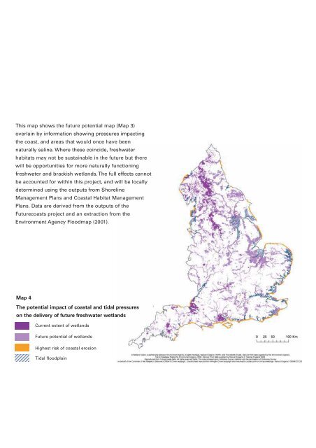
This map shows the future potential map (Map 3)<br />
overlain by information showing pressures impacting<br />
the coast, and areas that would once have been<br />
naturally saline. Where these coincide, freshwater<br />
habitats may not be sustainable in the future but there<br />
will be opportunities for more naturally functioning<br />
freshwater and brackish wetlands. The full effects cannot<br />
be accounted for within this project, and will be locally<br />
determined using the outputs from Shoreline<br />
Management Plans and Coastal Habitat Management<br />
Plans. Data are derived from the outputs of the<br />
Futurecoasts project and an extraction from the<br />
Environment Agency Floodmap (2001).<br />
Map 4<br />
The potential impact of coastal and tidal pressures<br />
on the delivery of future freshwater wetlands<br />
Current extent of wetlands<br />
Future potential of wetlands<br />
Highest risk of coastal erosion<br />
Tidal floodplain