

Columbia Pike Form Based Code - sacog
Columbia Pike Form Based Code - sacog
Columbia Pike Form Based Code - sacog

Create successful ePaper yourself
Turn your PDF publications into a flip-book with our unique Google optimized e-Paper software.
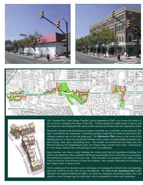
Neighborhood Center<br />
Western Gateway<br />
Village Center<br />
The <strong>Columbia</strong> <strong>Pike</strong> Urban Design Charrette, held in September of 2002, was a forum for citizens to<br />
get involved in designing the future of the <strong>Pike</strong>. Citizens gathered in small groups to discuss and<br />
draw ideas for redeveloping the <strong>Pike</strong>, and to build consensus on the ideas that were important to them.<br />
During the charrette week, the design team began to assemble one overall plan, incorporating the “big<br />
ideas” generated by the community. Community members stopped by the studio located on the <strong>Pike</strong>,<br />
offering continual input as the plan progressed. The Illustrative Plan (above) is the result of this<br />
planning process; it shows the hypothetical buildout of the corridor, locating building footprints (new<br />
and existing), open space, and parking areas. The corridor was divided into four study areas, the<br />
Western Gateway, the Neighborhood Center, the Village Center, and the Town Center. Each area has<br />
it’s own unique characteristics and challenges which were addressed.<br />
Quick sketches were done to study buildings that would result from the hypothetical building footprints<br />
in the Illustrative Plan, combined with the proposed height limits in the study areas and potential<br />
architectural regulations of the new code. These sketches were presented to the public, so they<br />
could envision the form and mass of future development. One example, illustrating new buildings in<br />
the Village Center, is shown at left.<br />
At the conclusion of the charrette week, work began on developing the detailed codes and regulating<br />
plans that would lay out the rules for new development. The Town Center Regulating Plan (right)<br />
illustrates the required building line (RBL), the street tree alignment and parking setback lines, and<br />
identifies a street frontage type for each street, which corresponds to written code regulations.


