Summer 2011, Volume 57, Number 3 - San Diego History Center
Summer 2011, Volume 57, Number 3 - San Diego History Center
Summer 2011, Volume 57, Number 3 - San Diego History Center

Create successful ePaper yourself
Turn your PDF publications into a flip-book with our unique Google optimized e-Paper software.
The Day the <strong>San</strong> <strong>Diego</strong> River Was Saved<br />
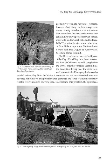
Fig. 1. Mildred Falls on Ritchie Creek showing its<br />
300-foot drop. Photo courtesy of the <strong>San</strong> <strong>Diego</strong><br />
River Park Foundation.<br />
productive wildlife habitats—riparian<br />
forests. And they harbor surprises:<br />
many county residents are not aware<br />
that a couple of the river’s tributaries also<br />
contain two truly spectacular wet-season<br />
waterfalls, Cedar Creek Falls and Mildred<br />
Falls. 1 The latter, located a few miles west<br />
of Pine Hills, drops some 300 feet down<br />
a sheer rock face (Figure 1). A more arid<br />
Yosemite comes to mind.<br />
The River, of course, was the birthplace<br />
of the City of <strong>San</strong> <strong>Diego</strong> and, by extension,<br />
the State of California as well. Long before<br />
the arrival of Father Junípero Serra in 1769,<br />
the benefits of living near the river were<br />
well known to the Kumeyaay Indians who<br />
resided in its valley. Both the Native Americans and the missionaries knew it as<br />
a source of both food and potable water, although the latter was not necessarily<br />
reliable twelve months of every year. To overcome this problem, the Spaniards<br />
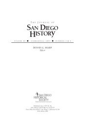
Fig. 2. Coast Highway bridge on the <strong>San</strong> <strong>Diego</strong> River destroyed by the 1916 flood. ©SDHC #6015.<br />
155

![[PDF] The Journal of San Diego History Vol 52: Nos 1 & 2](https://img.yumpu.com/25984149/1/172x260/pdf-the-journal-of-san-diego-history-vol-52-nos-1-2.jpg?quality=85)
![[PDF] The Journal of San Diego History - San Diego History Center](https://img.yumpu.com/25984131/1/172x260/pdf-the-journal-of-san-diego-history-san-diego-history-center.jpg?quality=85)