ScanEx - IFAW Project
ScanEx - IFAW Project
ScanEx - IFAW Project

Create successful ePaper yourself
Turn your PDF publications into a flip-book with our unique Google optimized e-Paper software.
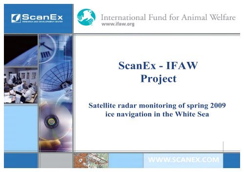
<strong>ScanEx</strong> - <strong>IFAW</strong><br />
<strong>Project</strong><br />
Satellite radar monitoring of spring 2009<br />
ice navigation in the White Sea
<strong>ScanEx</strong> - <strong>IFAW</strong><br />
Satellite Radar Monitoring of Ice Navigation<br />
in the White Sea<br />
Each ship passing through the ice herd of harp<br />
seals in the White Sea kills 500-1000 baby-seals<br />
400<br />
350<br />
300<br />
250<br />
200<br />
150<br />
100<br />
50<br />
0<br />
1998 1999 2000 2001 2002 2003 2004 2005 2006 2007 2008<br />
Decrease in the White Sea<br />
harp seals population
<strong>ScanEx</strong> - <strong>IFAW</strong>: a combination of aerial-photo<br />
survey and satellite radar monitoring<br />
adjustments<br />
<strong>IFAW</strong> conducts aerial survey for<br />
seal herds mapping
<strong>ScanEx</strong> - <strong>IFAW</strong>: a combination of aerial-photo<br />
survey and satellite radar monitoring<br />
adjustments<br />
ship passes<br />
<strong>ScanEx</strong> performs satellite-based radar<br />
monitoring to detect and document ice<br />
shipping channels<br />
ice ship roads
<strong>ScanEx</strong> - <strong>IFAW</strong>: a combination of aerial-photo<br />
survey and satellite radar monitoring<br />
Ice shipping channels in the White Sea.<br />
Radarsat-1, March 16, 2008<br />
Seal herds density outspread, White Sea,<br />
March 17, 2008
<strong>ScanEx</strong> - <strong>IFAW</strong>: a combination of aerial-photo<br />
survey and satellite radar monitoring<br />
Primary goals:<br />
ship routes<br />
documentation<br />
shipping impact<br />
assessments<br />
changes in legislation<br />
and shipping practices<br />
laying new channels<br />
bypassing seal herds