The Freducci Map of 1514-1515 - FIU Digital Collections
The Freducci Map of 1514-1515 - FIU Digital Collections
The Freducci Map of 1514-1515 - FIU Digital Collections

You also want an ePaper? Increase the reach of your titles
YUMPU automatically turns print PDFs into web optimized ePapers that Google loves.
A<br />
<strong>The</strong> <strong>Freducci</strong> <strong>Map</strong> <strong>of</strong> <strong>1514</strong>-<strong>1515</strong><br />
Ihtat it Discloses <strong>of</strong> Early Florida History<br />
by DAVID O. TRUE<br />
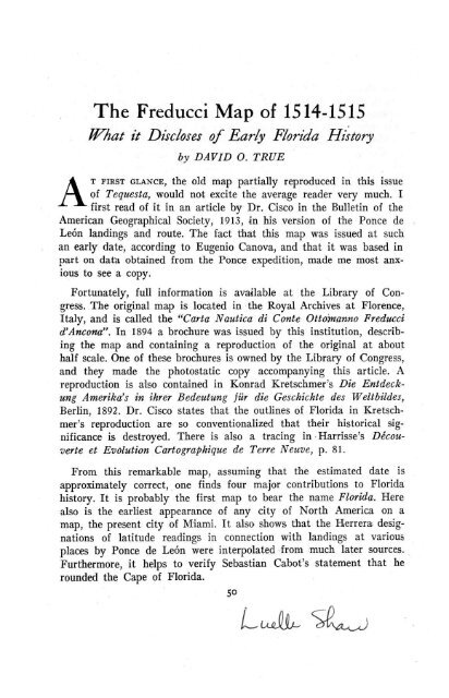
T FIRST GLANCE, the old map partially reproduced in this issue<br />
<strong>of</strong> Tequesta, would not excite the average reader very much. I<br />
first read <strong>of</strong> it in an article by Dr. Cisco in the Bulletin <strong>of</strong> the<br />
American Geographical Society, 1913, in his version <strong>of</strong> the Ponce de<br />
Le6n landings and route. <strong>The</strong> fact that this map was issued at such<br />
an early date, according to Eugenio Canova, and that it was based in<br />
part on data obtained from the Ponce expedition, made me most anxious<br />
to see a copy.<br />
Fortunately, full information is available at the Library <strong>of</strong> Congress.<br />
<strong>The</strong> original map is located in the Royal Archives at Florence,<br />
Italy, and is called the "Carta Nautica di Conte Ottoananno <strong>Freducci</strong><br />
d'Ancona". In 1894 a brochure was issued by this institution, describing<br />
the map and containing a reproduction <strong>of</strong> the original at about<br />
half scale. One <strong>of</strong> these brochures is owned by the Library <strong>of</strong> Congress,<br />
and they made the photostatic copy accompanying this article. A<br />
reproduction is also contained in Konrad Kretschmer's Die Entdeckung<br />
Amerika's in ihrer Bedeutung fiir die Geschichte des Weltbildes,<br />
Berlin, 1892. Dr. Cisco states that the outlines <strong>of</strong> Florida in Kretschmer's<br />
reproduction are so conventionalized that their historical significance<br />
is destroyed. <strong>The</strong>re is also a tracing in Harrisse's Decouverte<br />
et Evolution Cartographique de Terre Neuve, p. 81.<br />
From this remarkable map, assuming that the estimated date is<br />
approximately correct, one finds four major contributions to Florida<br />
history. It is probably the first map to bear the name Florida. Here<br />
also is the earliest appearance <strong>of</strong> any city <strong>of</strong> North America on a<br />
map, the present city <strong>of</strong> Miami. It also shows that the Herrera designations<br />
<strong>of</strong> latitude readings in connection with landings at various<br />
places by Ponce de Le6n were interpolated from much later sources.<br />
Furthermore, it helps to verify Sebastian Cabot's statement that he<br />
rounded the Cape <strong>of</strong> Florida.<br />
5o<br />
LISLjQ^ S^Li
Erratum: <strong>The</strong> top two and one-half lines <strong>of</strong> page 51 should read as follows:<br />
"On the <strong>Freducci</strong> map <strong>of</strong> Florida I Florda is the top name, where Florida is<br />
designated as an island, as was done by some other cartographers also in those<br />
early days." <strong>The</strong> only explorer fully authenticated to have cruised the Florida<br />
shores before Ponce was Sebastian, and possibly John Cabot. <strong>The</strong>ir evidence seemingly<br />
is <strong>of</strong> coasting some thousand miles <strong>of</strong> continuous shoreline. Relatively few<br />
map-makers portrayed Florida as an island.-D.O.T.
DAVID O. TRUE 51<br />
On the <strong>Freducci</strong> map <strong>of</strong> Florida, I. Florda (sic) is the top name, here<br />
Florida is designated as an island, for this was the belief <strong>of</strong> the early<br />
explorers. <strong>The</strong> Rio de Canoas is identified by Dr. Cisco as Indian<br />
River. <strong>The</strong> next place, on the map, reading down, is Chantio, which<br />
is Cautio in Kretschmer, the name that Herrera said was given to Florida<br />
by the Lucayan Indians. Ponta d'Arcifes is Point <strong>of</strong> Reefs, spelled<br />
Arracifes by Herrera. Herrera mentions the Rio de la Cruz, River<br />
<strong>of</strong> the Cross, designated by its cruciform shape on the <strong>Freducci</strong> map,<br />
stated to be Jupiter Inlet by Dr. Cisco: "No other inlet on' the coast<br />
has three branching streams at its head." One could almost believe<br />
that it means Lake Okeechobee. <strong>The</strong> Cabo de Corrientes <strong>of</strong> Herrera<br />
is the Cabo de Setos, Cape <strong>of</strong> Pales, in <strong>Freducci</strong>. Abacoa was Abaida.:<br />
in Herrera, an Indian town near Lake Worth Inlet, according to Dr.<br />
Cisco. He identifies the Rio Salado, Salty River, with New River<br />
Inlet. Herrera in his account mentions two keys that are not on <strong>Freducci</strong>,<br />
Santa Marta and Pola. On the <strong>Freducci</strong> map are El Nirda and<br />
Canbei. Canbei becomes Camboie in Kretschmer, and is probably Herrera's<br />
Achecambei. One <strong>of</strong> the two Indian towns on the Keys, according<br />
to Fontaneda, was named Guaragunbe or Guaragumbe; perhaps<br />
all <strong>of</strong> these were what is now known as Matecumbe. Los Martires <strong>of</strong><br />
both Herrera and <strong>Freducci</strong>, is a translation <strong>of</strong> the word Cuchiyaga <strong>of</strong><br />
the Indians, as shown in Fontaneda's Memoir; it thus alludes to Indian<br />
tribulations, not those <strong>of</strong> Spaniards, who had not yet discovered<br />
the New World when the name was first used. Ponce merely translated<br />
the name already found in use on the Keys, though Herrera<br />
said it was bestowed upon them by Ponce. Matanga is in both Herrera<br />
and <strong>Freducci</strong>, it alludes to the killing <strong>of</strong> some Indians by Ponce on his<br />
first journey and contributes to the evidence that this <strong>Freducci</strong> map<br />
was compiled from Ponce de Le6n sources to some extent. <strong>The</strong> two<br />
West Coast names, Guchi and Stababa, are not identifiable from the<br />
Herrera records.<br />
Chequiche is spelled Chequescha by Herrera, and this is the wellknown<br />
Indian town Tequesta, generally stated to have been situated<br />
on the Miami River, where it empties into the bay. Ponce may have<br />
stopped <strong>of</strong>f to visit it on his way to the West Coast, as some authors<br />
report, but Herrera definitely stated that he arrived at this place on<br />
Sunday, July 2, 1513. This is the earliest mention <strong>of</strong> Miami, by its<br />
ancient Indian name. Miami thus becomes the first city on the continent<br />
<strong>of</strong> North America to have been definitely visited by Ponce, or
\! \<br />
.. I "<br />
45°<br />
' \ -<br />
45<br />
Flria e<br />
m an<br />
Florida, the Bahamas and Cuba. Scale<br />
a oa' /1 o oina m<br />
approximately 9/10 <strong>of</strong> original map.
DAVID O. TRUE 53<br />
by any other discoverer <strong>of</strong> note, and to have been identified by a<br />
substantiating map. <strong>The</strong> name Miami came from Mayaimi, equally<br />
as old at the name Tequesta. It was the Calusa name for Lake Okeechobee,<br />
meaning "big water."<br />
Dr. Cisco states that the <strong>Freducci</strong> map did not show "any indicated<br />
latitudes", but it can be readily seen that the line that <strong>Freducci</strong><br />
drew, cutting through the Strait <strong>of</strong> Gibraltar, represents 350 north,<br />
while the same position on a modern map is 360. Following this line<br />
westward, one notes that it runs about half way between Cuba and<br />
Florida. On this map the tip <strong>of</strong> Florida below Chequiche,, is at 390<br />
north and this is an error <strong>of</strong> more than 13 degrees! On a modern<br />
map 390 is <strong>of</strong>f the coast <strong>of</strong> Delaware. Most <strong>of</strong> the other early maps<br />
and charts contain similar errors; rarely was one drawn which did<br />
not have the Tropic <strong>of</strong> Cancer south <strong>of</strong> Cuba, instead <strong>of</strong> north where<br />
it belongs. <strong>The</strong> <strong>Freducci</strong> map was based to some extent on Ponce's<br />
data, and if Ponce had a map or chart on which latitudes were as<br />
relatively exact as they are given in Herrera, it seems strange that<br />
no cartographer knew about it for many years afterward. If Ponce<br />
had decided to go ashore and dig a well at 280 8' north, it would have<br />
been located on the very southernmost tip <strong>of</strong> the Island <strong>of</strong> Cuba,<br />
according to this contemporary map <strong>of</strong> <strong>Freducci</strong>.<br />
To me there seems to be but one conclusion: Herrera interpolated<br />
all these locations very much later from what, in his day, were modern<br />
charts. As far as they are used by themselves to verify Ponce's<br />
landings, they are without value. <strong>The</strong>y express Herrera's opinion written<br />
nearly a century later. Anyone interested in tracing Ponce's journey<br />
will find the writings <strong>of</strong> Charles B. Reynolds in accord with the<br />
opinions advanced by Dr. Cisco. <strong>The</strong> reasons for believing that a<br />
landfall was made in the vicinity <strong>of</strong> St. Augustine, are presented by<br />
Mr. T. Frederick Davis in the Ponce de Le6n number <strong>of</strong> the Florida<br />
Historical Quarterly for July, 1935. Some investigators are interested<br />
in the theory that he sailed far to the north on the west coast <strong>of</strong> Florida;<br />
the <strong>Freducci</strong> map with its two additional names should interest<br />
them.<br />
One must admit that Herrera was an indefatigable worker, for we<br />
have Mufioz' testimony that he probably took his data about the<br />
fabulous River <strong>of</strong> Youth from Fontaneda. One <strong>of</strong> his other interpolations<br />
is shown in his use <strong>of</strong> the name Carlos for the chief <strong>of</strong> the Calusas<br />
in the time <strong>of</strong> Ponce de Le6n. <strong>The</strong> second chief to assume this name
54 TEQUESTA<br />
was about 25 years <strong>of</strong> age in 1566; his father Senquene had been<br />
the first to take it, because he had been told that it was the name <strong>of</strong><br />
the greatest King <strong>of</strong> the Christians (Charles V). Charles V did not<br />
come to the throne until after Ponce's first voyage, and it is unlikely<br />
that Senquene heard <strong>of</strong> him until after 1545, the date <strong>of</strong> the Fontaneda<br />
wreck, when some 200 Spaniards were taken captive by the Indians.*<br />
This question <strong>of</strong> latitude has a bearing on the testimony <strong>of</strong> Sebastian<br />
Cabot. Peter Martyr, reporting a conversation with Cabot in<br />
1512, wrote <strong>of</strong> it in the 3rd decade <strong>of</strong> his history:<br />
"Thus seeing such heapes <strong>of</strong> yce before him, he was enforced<br />
to turne his sailes and follow the West, so coasting still by the<br />
shore, that he was thereby brought so farre into the South, by<br />
reason <strong>of</strong> the land bending so much Southwards, that it was there<br />
almost eqyal in latitude, with the sea Fretum Herculeum, having<br />
the Northpole elevate in manner in the same degree. He sailed<br />
likewise in this tract so farre towards the West, that he had the<br />
Island <strong>of</strong> Cuba on his left hand, in manner in the same degree<br />
<strong>of</strong> longitude. As hee travelled by the coastes <strong>of</strong> this great land<br />
(which he named Baccalaos) he said that hee found the like<br />
course <strong>of</strong> the waters toward the West, but the same to runne<br />
more s<strong>of</strong>tly and gently than the swift waters which the Spaniards<br />
found in their navigations Southward. . . . Cabot is my<br />
friend, whom I use familiarly, and delight to have him sometimes<br />
keepe me company in mine own house."<br />
Three compelling reasons for believing that Sebastian Cabot reported<br />
in 1512 <strong>of</strong> having rounded the Cape <strong>of</strong> Florida, either with<br />
his father on one <strong>of</strong> his two trips, or on an expedition <strong>of</strong> his own<br />
in 1508, as advanced by Williamson in his Voyages <strong>of</strong> the Cabots, are<br />
contained in this account by Peter Martyr. If Cabot had not known<br />
<strong>of</strong> Florida, he would not have been able to state that by following<br />
the coastline he "had the Island <strong>of</strong> Cuba on his left hand." To know<br />
<strong>of</strong> currents counter to the Gulf Stream <strong>of</strong>f the South Florida shores<br />
before Ponce ever saw the country, took competent first hand information.<br />
This is a remarkable detail that too many Cabot historians<br />
overlook.<br />
<strong>The</strong> third reason is the one to which the <strong>Freducci</strong> map makes another<br />
contribution. Cabot said that he sailed as far south as to be parallel<br />
with Fretum Herculeum (Strait <strong>of</strong> Gibraltar) and <strong>of</strong> returning from<br />
*See Connor's trarfslation <strong>of</strong> de Meris' Pedro Menindez de Avils.
DAVID O. TRUE 55<br />
that latitude to England. On a modern map, this would be from the<br />
coast <strong>of</strong> North Carolina. So the Cabot experts state that Cabot sailed<br />
south to Carolina and returned from there, instead <strong>of</strong> realizing that<br />
360 at his time was, on the charts and maps, in the Straits <strong>of</strong> Florida.<br />
Other readers will probably find more interesting facts from the<br />
<strong>Freducci</strong> map. To me it has been thoroughly exciting, even to see<br />
the East Coast line veering so far westward as it leaves Miami<br />
and swings toward Jacksonville. <strong>Freducci</strong> knew his Florida and contributed<br />
more to our knowledge than we might expect from any such<br />
single document.