Miami During the Civil War - FIU Digital Collections
Miami During the Civil War - FIU Digital Collections
Miami During the Civil War - FIU Digital Collections

You also want an ePaper? Increase the reach of your titles
YUMPU automatically turns print PDFs into web optimized ePapers that Google loves.
34 TEQUESTA<br />
and 42 by 20 feet. Using local wood and imported lumber, <strong>the</strong> soldiers<br />
added five new officers' quarters, a hospital, guardhouse, magazine,<br />
stables, and o<strong>the</strong>r smaller buildings. <strong>During</strong> this period <strong>the</strong><br />
complex consisted of approximately 13 buildings with no walls. 10 It<br />
greatly impressed a visitor in March of 1858 who wrote, it was "a<br />
beautiful sight; <strong>the</strong> stars and stripes floating from a tall flagstaff<br />
erected on <strong>the</strong> parade ground, all clean and covered with Bermuda<br />
grass . . . planted with flowers, shrubbery and vegetables of all<br />
kinds." 1<br />
The Army left Fort Dallas in <strong>the</strong> hands of caretakers and <strong>the</strong><br />
locals put <strong>the</strong> buildings to good use as a residence, trading post, and<br />
temporary quarters for newly arrived settlers. It remained <strong>the</strong> center<br />
of <strong>the</strong> pioneer community throughout most of <strong>the</strong> second half <strong>the</strong> 19th<br />
century. 12 After <strong>the</strong> third and final Seminole Indian <strong>War</strong> ended in<br />
1858, a small number of undefeated Seminoles slipped deeper into <strong>the</strong><br />
vastness of <strong>the</strong> Everglades, but <strong>the</strong> continual warfare had damaged<br />
<strong>Miami</strong>'s reputation.<br />
The Pioneers<br />
The pioneers who stayed to make a home in this wilderness<br />
depended on <strong>the</strong> ocean as a link to <strong>the</strong> world and as a source of<br />
income. A busy sea lane was directly offshore and parallel to <strong>the</strong><br />
coast. <strong>During</strong> <strong>the</strong> first half <strong>the</strong> 19th century, one of <strong>the</strong> leading activities<br />
was "wrecking," or <strong>the</strong> legal and illegal salvaging of ships<br />
stranded or destroyed on <strong>the</strong> treacherous Florida Reef. In <strong>the</strong> 1850<br />
and 1860 Censuses some reported <strong>the</strong>ir occupation as "mariner," a<br />
euphemism for wrecker. By 1861 improved maps, steam powered<br />
ships, and <strong>the</strong> Cape Florida Lighthouse reduced <strong>the</strong> number of wrecks<br />
along <strong>the</strong> coast.<br />
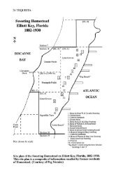
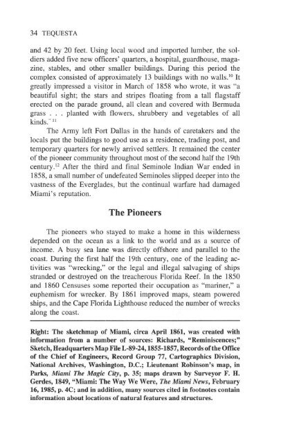
Right: The sketchmap of <strong>Miami</strong>, circa April 1861, was created with<br />
information from a number of sources: Richards, "Reminiscences;"<br />
Sketch, Headquarters Map File L-89-24,1855-1857, Records of <strong>the</strong> Office<br />
of <strong>the</strong> Chief of Engineers, Record Group 77, Cartographics Division,<br />
National Archives, Washington, D.C.; Lieutenant Robinson's map, in<br />
Parks, <strong>Miami</strong> The Magic City, p. 35; maps drawn by Surveyor F. H.<br />
Gerdes, 1849, "<strong>Miami</strong>: The Way We Were, The <strong>Miami</strong> News, February<br />
16, 1985, p. 4C; and in addition, many sources cited in footnotes contain<br />
information about locations of natural features and structures.