Summer 2009 - Scottish Natural Heritage
Summer 2009 - Scottish Natural Heritage
Summer 2009 - Scottish Natural Heritage

Create successful ePaper yourself
Turn your PDF publications into a flip-book with our unique Google optimized e-Paper software.
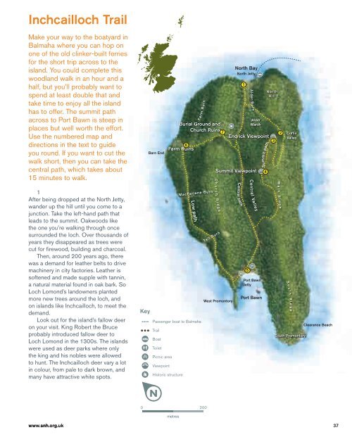
Inchcailloch Trail<br />
Make your way to the boatyard in<br />
Balmaha where you can hop on<br />
one of the old clinker-built ferries<br />
for the short trip across to the<br />
island. You could complete this<br />
woodland walk in an hour and a<br />
half, but you’ll probably want to<br />
spend at least double that and<br />
take time to enjoy all the island<br />
has to offer. The summit path<br />
across to Port Bawn is steep in<br />
places but well worth the effort.<br />
Use the numbered map and<br />
directions in the text to guide<br />
you round. If you want to cut the<br />
walk short, then you can take the<br />
central path, which takes about<br />
15 minutes to walk.<br />
1<br />
After being dropped at the North Jetty,<br />
wander up the hill until you come to a<br />
junction. Take the left-hand path that<br />
leads to the summit. Oakwoods like<br />
the one you’re walking through once<br />
surrounded the loch. Over thousands of<br />
years they disappeared as trees were<br />
cut for fi rewood, building and charcoal.<br />
Then, around 200 years ago, there<br />
was a demand for leather belts to drive<br />
machinery in city factories. Leather is<br />
softened and made supple with tannin,<br />
a natural material found in oak bark. So<br />
Loch Lomond’s landowners planted<br />
more new trees around the loch, and<br />
on islands like Inchcailloch, to meet the<br />
demand.<br />
Look out for the island’s fallow deer<br />
on your visit. King Robert the Bruce<br />
probably introduced fallow deer to<br />
Loch Lomond in the 1300s. The islands<br />
were used as deer parks where only<br />
the king and his nobles were allowed<br />
to hunt. The Inchcailloch deer vary a lot<br />
in colour, from pale to dark brown, and<br />
many have attractive white spots.<br />
Key<br />
Barn End<br />
Burial Ground and<br />
Church Ruins 7<br />
6<br />
Farm Ruins<br />
MacFarlane Burn<br />
Low path<br />
Passenger boat to Balmaha<br />
Trail<br />
Boat<br />
Toilet<br />
Picnic area<br />
Viewpoint<br />
Historic structure<br />
Farm Burn<br />
Tait Burn<br />
West Promontory<br />
North Bay<br />
North Jetty<br />
Alder<br />
Marsh<br />
Summit Viewpoint<br />
C h u r c h R i<br />
d g e<br />
Central path<br />
1<br />
Alder Burn<br />
Central Valley<br />
Port Bawn<br />
Jetty<br />
Port Bawn<br />
Summit path<br />
North<br />
Hill<br />
Endrick Viewpoint<br />
3<br />
5<br />
4<br />
2<br />
M a i n R i d g e<br />
Coffin<br />
Valley<br />
S o u t<br />
h R i<br />
d g e<br />
South Promontory<br />
Clearance Beach<br />
0 200<br />
metres<br />
www.snh.org.uk<br />
37