2010 Artificial Reef Monitoring Report - St. Lucie County
2010 Artificial Reef Monitoring Report - St. Lucie County
2010 Artificial Reef Monitoring Report - St. Lucie County

Create successful ePaper yourself
Turn your PDF publications into a flip-book with our unique Google optimized e-Paper software.
<strong>St</strong>. <strong>Lucie</strong> <strong>County</strong> <strong>Artificial</strong> <strong>Reef</strong> <strong>Monitoring</strong> Program<br />
FISHAMERICA FOUNDATION REEFS<br />
DMC Barge/500 Ton Pile — 1 st Annual <strong>Monitoring</strong><br />
1,000 Ton Pile — 1 st Annual <strong>Monitoring</strong><br />
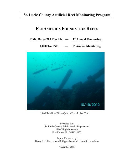
1,000 Ton <strong>Reef</strong> Pile – Quite a Prolific <strong>Reef</strong> Site<br />
Prepared for:<br />
<strong>St</strong>. <strong>Lucie</strong> <strong>County</strong> Public Works Department<br />
2300 Virginia Avenue<br />
Fort Pierce, FL 34982-5652<br />
<strong>Report</strong> Prepared by:<br />
Kerry L. Dillon, James B. Oppenborn and Helen K. Harralson<br />
November <strong>2010</strong>
ST. LUCIE COUNTY ARTIFICIAL REEF MONITORING November <strong>2010</strong><br />
Table of Contents<br />
1 Introduction ........................................................................................................... 3<br />
2 Methodology ........................................................................................................... 3<br />
3 <strong>Reef</strong> Locations ........................................................................................................ 5<br />
3.1 DMC Barge/500 Ton Pile <strong>Reef</strong> ............................................................................... 5<br />
3.2 1,000 Ton Pile <strong>Reef</strong> ................................................................................................. 7<br />
4 History of the <strong>Artificial</strong> <strong>Reef</strong>s ............................................................................... 8<br />
4.1 DMC Barge/500 Ton Pile <strong>Reef</strong> Deployments ......................................................... 8<br />
4.2 1,000 Ton Pile <strong>Reef</strong> Deployments ........................................................................... 9<br />
5 Annual <strong>Monitoring</strong> .............................................................................................. 10<br />
5.1 DMC Barge/500 Ton Pile <strong>Reef</strong> - First Annual <strong>Monitoring</strong> ................................... 10<br />
5.2 1,000 Ton Pile <strong>Reef</strong> - First Annual <strong>Monitoring</strong> Conditions .................................. 15<br />
6 Summaries ............................................................................................................ 19<br />
6.1 DMC Barge/500 Ton Pile <strong>Reef</strong> ............................................................................. 19<br />
6.2 1,000 Ton Pile <strong>Reef</strong> ............................................................................................... 19<br />
List of Tables<br />
Table 1. <strong>St</strong>. <strong>Lucie</strong> <strong>County</strong> <strong>Artificial</strong> <strong>Reef</strong> Deployments, 2005-2009 ...................................... 7<br />
Table 2. DMC Barge/500 Ton Pile Fish Census, 10/13/<strong>2010</strong> ............................................... 12<br />
Table 3. DMC Barge/500 Ton Pile Benthic Census, 10/13/<strong>2010</strong> .......................................... 14<br />
Table 4 1,000 Ton Pile Fish Census, 10/13/<strong>2010</strong> .................................................................. 16<br />
Table 5. 1,000 Ton Pile, Benthic Census, 10/13/<strong>2010</strong> ........................................................... 18<br />
List of Figures<br />
Figure 1. Arrival of DMC Barge on Site Prior to Deployment ............................................... 5<br />
Figure 2. Permitted <strong>St</strong>. <strong>Lucie</strong> <strong>County</strong> <strong>Artificial</strong> <strong>Reef</strong> Sites ..................................................... 6<br />
Figure 3. 500 Tons of Secondary Concrete Leaving Fort Pierce Inlet ..................................... 8<br />
Figure 4. Secondary Concrete Leaving Fort Pierce Inlet before Deployment ......................... 9<br />
Figure 5. <strong>St</strong>acking of bridge post and rail on DMC Barge/500 Ton Pile reef ....................... 10<br />
Figure 6. DMC Barge/500 Ton Pile − Prolific <strong>Reef</strong> as Seen During 1 st Annual <strong>Monitoring</strong> 10<br />
Figure 7. Culverts upright on barge deck provide desirable vertical profile ......................... 11<br />
Figure 8. Jim Oppenborn, SLC Coastal Resources Supervisor, observes reef structure and marine life .. 11<br />
Figure 9. DMC Barge/ 500 Ton Pile 1 st annual monitoring underwater photographs ........... 13<br />
Figure 10. 1,000 Ton Pile 1 st annual monitoring underwater photographs ............................ 15<br />
Figure 11. 1,000 Ton Pile 1 st annual monitoring underwater photographs ............................ 17<br />
Figure 12. Colonies of benthic organisms, 1000 Ton Pile ...................................................... 18<br />
Figure 13. FishAmerica Foundation <strong>Reef</strong> Fish Species Data Comparison…………………………..20<br />
Figure 14. Snapper-Grouper Complex Data Comparison………………………………………………21<br />
Kerry L. Dillon., Sea Rover Services, Inc.<br />
2
ST. LUCIE COUNTY ARTIFICIAL REEF MONITORING November <strong>2010</strong><br />
1st Annual <strong>Monitoring</strong> of the DMC Barge/500 Ton Pile <strong>Reef</strong><br />
DMC Barge − Deployed 6/10/2009<br />
500 Ton Pile − Deployed 6/11/2009<br />
1 st Annual <strong>Monitoring</strong> of the 1,000 Ton Pile <strong>Reef</strong><br />
1,000 Ton Pile − Deployed 8/31/2009<br />
1 Introduction<br />
This report presents the first annual artificial reef monitoring surveys of the DMC Barge/500<br />
Ton Pile and the 1,000 Ton Pile sites. Both sites are located within the FishAmerica Foundation<br />
Project area (FAF-8079).<br />
The DMC Barge/500 Ton Pile reef was deployed June 10-11, 2009, and the 1,000 Ton Pile<br />
<strong>Reef</strong> deployed on August 31, 2009. Both of these artificial reefs are located 6 nautical miles offshore<br />
of <strong>St</strong>. <strong>Lucie</strong> <strong>County</strong>, Florida within the permitted ‘North <strong>County</strong> Nearshore Site.’<br />
The deployment work was performed for <strong>St</strong>. <strong>Lucie</strong> <strong>County</strong> (SLC) with a donation from Fish<br />
America Foundation, grant funding from the Florida Fish and Wildlife Conservation Commission<br />
(FWC) and a donation from Bob Herbst Jr. The primary objectives of this project were to:<br />
Verify and document reef locations,<br />
Document biological activity (benthic organisms and coastal demersal finfish) and<br />
Evaluate material performance, (stability and condition of the reef materials, profile,<br />
scour and settlement, etc.).<br />
The North <strong>County</strong> Nearshore Site area’s southwest boundary is located 5.6 miles NE of Ft.<br />
Pierce Inlet (Figure 2) with an average water depth of 54 feet. The bottom is a mix of coarse sand<br />
and shell fragments. To date there have been no natural reefs, or natural hard bottom areas located in<br />
this area.<br />
2 Methodology<br />
The field work surveys were performed by skilled divers using visual techniques and still<br />
underwater photography of the reef areas. Kerry Dillon (Sea Rover Services, Inc.) primarily<br />
performed the field work and report writing for this annual monitoring. Additional highly<br />
experienced scientific divers were employed to assist in the performance of field work, along with<br />
data analysis by a marine biologist. James Oppenborn, <strong>St</strong>. <strong>Lucie</strong> <strong>County</strong> Coastal Resources<br />
Supervisor, participated in monitoring survey dives, in addition to contributions of photographs and<br />
reef construction data. The field work is described as follows:<br />
Kerry L. Dillon., Sea Rover Services, Inc. 3
ST. LUCIE COUNTY ARTIFICIAL REEF MONITORING November <strong>2010</strong><br />
Physical reef structure – diver inspections and measurements were made to determine<br />
changes in the reef structure, including scour, settlement, horizontal extent, and movement of reef<br />
components. <strong>Reef</strong> structure depths were acquired by using dive computers for measurements of the<br />
bottom, along with the highest and average depths of the reef materials. The natural bottom depths<br />
away from the reefs were compared to the maximum depths adjacent to the reefs to assess scour.<br />
Over time, changes in the reef heights may be used to assess settlement of the materials. Distance<br />
measurements of the horizontal extent of the reefs were made using a tape measure.<br />
Biological surveys – data collection methods included conducting the underwater ‘Roaming<br />
Diver’ visual assessment method. 1 This fish count technique assesses the relative fish species<br />
diversity and their quantities. Data were recorded on waterproof slates during the reef assessments.<br />
Dive data such as date and time, bottom time, depth, currents and water temperature were recorded.<br />
The relative abundance for each species was recorded based on the numbers observed, which can be<br />
described by the following categories:<br />
‘S’ for a Single individual seen of that species<br />
‘F’ for Few 2 - 10 individuals<br />
‘M’ for Many 11 - 100 individuals<br />
‘A’ for Abundant > 100 individuals<br />
These categories are widely utilized by the REEF agency (<strong>Reef</strong> Environmental Education<br />
Foundation) and accepted by the scientific community for conducting underwater species surveys by<br />
divers on natural and artificial reefs worldwide.<br />
All data taken during each dive was thoroughly reviewed on the boat following each dive<br />
before being transferred into field log books. These practices assure that correct and complete data<br />
were recorded and saved.<br />
Photo-documentation – underwater digital still cameras were used to document the reefs’<br />
condition and other observations that were made during the dives. These will be utilized in<br />
comparing reef structure and marine life in subsequent reef surveys. Representative photographs are<br />
included in this report.<br />
Kerry L. Dillon., Sea Rover Services, Inc. 4
Photo courtesy of Jim Oppenborn<br />
ST. LUCIE COUNTY ARTIFICIAL REEF MONITORING November <strong>2010</strong><br />
3 <strong>Reef</strong> Locations<br />
The GPS coordinates for the locations of the DMC Barge/500 Ton Pile and the 1,000 Ton Pile<br />
reefs are shown in Table 1. These artificial reefs were developed as follows:<br />
Figure 1. Arrival of DMC Barge on Site Prior to Deployment<br />
3.1 DMC Barge/500 Ton Pile <strong>Reef</strong><br />
The DMC Barge was deployed on June 10, 2009. On June 11, 2009, 500 tons of mixed<br />
secondary concrete materials were deployed on and next to the barge. McCulley Marine Services<br />
Inc. (MMS) provided materials delivery services.<br />
These deployments were:<br />
6/10/2009 – DMC Barge, one 65’steel inland barge deployed<br />
6/11//2009 – 500 Ton Pile, 500 tons of mixed secondary concrete materials deployed<br />
Kerry L. Dillon., Sea Rover Services, Inc. 5
ST. LUCIE COUNTY ARTIFICIAL REEF MONITORING November <strong>2010</strong><br />
Figure 2. Permitted <strong>St</strong>. <strong>Lucie</strong> <strong>County</strong> <strong>Artificial</strong> <strong>Reef</strong> Sites<br />
Kerry L. Dillon., Sea Rover Services, Inc. 6
ST. LUCIE COUNTY ARTIFICIAL REEF MONITORING November <strong>2010</strong><br />
3.2 1,000 Ton Pile <strong>Reef</strong><br />
The 1,000 Ton Pile was created on August 31, 2009 by the deployment of one barge load of<br />
mixed secondary concrete materials. McCulley Marine Services, Inc. (MMS) provided materials<br />
delivery services.<br />
8/31/2009 – 1,000 tons of mixed secondary concrete materials<br />
Table 1. <strong>St</strong>. <strong>Lucie</strong> <strong>County</strong> <strong>Artificial</strong> <strong>Reef</strong> Deployments, 2005-2009<br />
ST. LUCIE COUNTY ARTIFICIAL REEF DEPLOYMENTS<br />
Deployment<br />
Date<br />
Latitude Longitude Zmax Zmin Profile Materials Name<br />
8/17/2005 27*26.675'N 80*10.305'W 55 43 12 440 tons FEC railroad ties<br />
27*26.670'N 80*10.295'W 55 43 12 FEC railroad ties<br />
9/30/2005 27*26.687'N 80*10.333'W 55 35 20 340 tons FPL materials<br />
5/4/2006 27*26.402'N 80*09.601'W 54 43 11 490 tons dock piles<br />
5/6/2006 27*26.633'N 80*10.107'W 54 44 10 572 tons dock piles<br />
5/9/2006 27*26.531'N 80*09.936'W 53 45 8 515 tons mixed concrete materials<br />
5/11/2006 27*26.750'N 80*10.208'W 54 44 10 523 tons mixed concrete materials SKA <strong>Reef</strong><br />
5/15/2006<br />
1/31/2007<br />
27*26.743'N<br />
27*26.777'N<br />
27*26.743'N<br />
27*26.777'N<br />
80*10.214'W<br />
80*10.229'W<br />
80*10.214'W<br />
80*10.229'W<br />
56<br />
56<br />
46<br />
46<br />
2/7/2007 27*26.777'N 80*10.229'W 56 37<br />
140' <strong>St</strong>erling Barge - Bow<br />
140' <strong>St</strong>erling Barge - <strong>St</strong>ern<br />
56 35 19 555 tons Civic Center materials<br />
539 tons mixed concrete materials<br />
(Civic Center and culverts)<br />
Civic Center<br />
<strong>Reef</strong><br />
Civic Center<br />
<strong>Reef</strong><br />
Civic Center<br />
<strong>Reef</strong><br />
6/4/2007 27*23.168'N 80*03.704'W 95 84 11 526 tons mixed concrete materials Midway <strong>Reef</strong><br />
6/6/2007 27*23.596'N 80*03.668'W 91 73 21 485 tons mixed concrete materials N <strong>Reef</strong><br />
6/8/2007 27*23.465'N 80*03.707'W 89 76 12 473 tons mixed concrete materials SW <strong>Reef</strong><br />
6/9/2007 27*23.464'N 80*03.619'W 92 74 18 526 tons mixed concrete materials SE <strong>Reef</strong><br />
12/6/2007<br />
12/8/2007<br />
2/16/2008<br />
2/24/2008<br />
27*24.048'N 80*02.206'W 122 103 19<br />
27*24.103'N 80*01.577'W 140 122 18<br />
500 tons mixed concrete materials +<br />
500 tons concrete RR ties<br />
500 tons mixed concrete materials +<br />
500 tons FEC railroad ties<br />
120-ft. <strong>Reef</strong><br />
140-ft. <strong>Reef</strong><br />
8/25/2008<br />
526 tons mixed concrete materials + Bob Herbst Sr.<br />
27*22.990'N 80*03.699'W 93 76 17<br />
8/26/2008 481 tons mixed concrete materials <strong>Reef</strong><br />
8/27/2008<br />
630 tons mixed concrete materials + Bob Herbst Jr.<br />
27*26.767'N 80*09.538'W 55 34 21<br />
8/28/2008 461 tons mixed concrete materials <strong>Reef</strong><br />
9/17/2008 27*24.132'N 80*01.114'W 152 133 19 Tug Lee (50' tug)<br />
6/10/2009 27*31.213'N 80*11.158'W 53 48 5 DMC Barge (65" inland barge)<br />
6/11/2009 27*31.214'N 80*11.169'W 64 50 14 500 tons mixed concrete materials<br />
Tug Lesley<br />
Lee <strong>Reef</strong><br />
DMC Barge,<br />
FAF <strong>Reef</strong><br />
500 Ton Pile,<br />
FAF <strong>Reef</strong><br />
8/31/2009 27*31.279'N 80*11.103'W 53 500 tons mixed concrete materials FAF <strong>Reef</strong><br />
8/31/2009 27*31.187'N 80*11.107'W 54 27 27 1,000 tons mixed concrete materials<br />
1000 Ton Pile,<br />
FAF <strong>Reef</strong><br />
Kerry L. Dillon., Sea Rover Services, Inc. 7
Photo courtesy of Jim Oppenborn<br />
ST. LUCIE COUNTY ARTIFICIAL REEF MONITORING November <strong>2010</strong><br />
4 History of the <strong>Artificial</strong> <strong>Reef</strong>s<br />
4.1 DMC Barge/500 Ton Pile <strong>Reef</strong> Deployments<br />
On June 4, 2009, pre-deployment survey dives were conducted by Kenny Smith and James<br />
Oppenborn. The DMC Barge was deployed on June 10, 2009 and settled in an up-right position.<br />
Deployment of the barge was performed by McCulley Marine Services of Ft. Pierce, Florida utilizing<br />
their tugboats, captains, crew and barges.<br />
An initial post-deployment survey dive was performed on November 1, 2009, by Sea Rover<br />
Services of <strong>St</strong>uart, Florida and Jim Oppenborn of SLC.<br />
Figure 3. 500 Tons of Secondary Concrete Leaving Fort Pierce Inlet<br />
Kerry L. Dillon., Sea Rover Services, Inc. 8
Photo courtesy of Jim Oppenborn<br />
ST. LUCIE COUNTY ARTIFICIAL REEF MONITORING November <strong>2010</strong><br />
4.2 1,000 Ton Pile <strong>Reef</strong> Deployments<br />
On August 31, 2009, a volunteer diver conducts a sweep of the deployment area using her<br />
boat’s depth finder. No anomalous readings were found.<br />
Figure 4. Secondary Concrete Leaving Fort Pierce Inlet before Deployment<br />
Deployment of the barge was performed by McCulley Marine Services of Ft. Pierce, Florida<br />
utilizing their tugboats, captains, crew and barges.<br />
Kerry L. Dillon., Sea Rover Services, Inc. 9
ST. LUCIE COUNTY ARTIFICIAL REEF MONITORING November <strong>2010</strong><br />
5 Annual <strong>Monitoring</strong><br />
5.1 DMC Barge/500 Ton Pile <strong>Reef</strong> - First Annual <strong>Monitoring</strong><br />
Figure 6. DMC Barge/500 Ton Pile − Prolific<br />
<strong>Reef</strong> as Seen During 1 st Annual <strong>Monitoring</strong><br />
Figure 5. <strong>St</strong>acking of bridge post and rail on<br />
DMC Barge/500 Ton Pile reef<br />
On October 13, <strong>2010</strong>, the first annual monitoring was performed with the following data collected:<br />
DMC Barge, Maximum water depth = 64 feet<br />
DMC Barge, Vessel deck depth = 57 feet<br />
DMC Barge, <strong>Reef</strong> crest depth = 50 feet<br />
DMC Barge, Maximum reef relief = 14 feet<br />
DMC Barge, Vessel bow orientation = 220°<br />
500 Ton Pile, Maximum water depth = 65 feet<br />
500 Ton Pile, <strong>Reef</strong> crest depth = 48 feet<br />
500 Ton Pile, Maximum reef relief = 17 feet<br />
Surface water temperature = 80° F<br />
Bottom water temperature = 80° F<br />
Thermocline depth = None<br />
Current at Surface = 1/4 knot to the North<br />
Current at Bottom = 1/8 knot to the North<br />
Visibility Near Surface = 60 feet<br />
Visibility at Bottom = 80 feet<br />
Kerry L. Dillon., Sea Rover Services, Inc. 10
ST. LUCIE COUNTY ARTIFICIAL REEF MONITORING November <strong>2010</strong><br />
A detailed underwater survey of the DMC Barge/500 Ton Pile <strong>Reef</strong> was performed by a team<br />
of divers. The barge lies in a NE-SW orientation, with the stern to the NE and the bow to the SW.<br />
Concrete materials are stacked on the deck of the barge and alongside the vessel.<br />
Fish census data for the first annual monitoring of <strong>2010</strong>, is presented in Table 2. Species were<br />
positively identified and their quantities were listed utilizing the Roving Diver method. Twenty-eight<br />
species of fish were identified during this survey.<br />
Figure 7. Culverts upright on<br />
barge deck provide desirable<br />
vertical profile<br />
Figure 8. Jim Oppenborn, SLC<br />
Coastal Resources Supervisor,<br />
observes structure & marine life<br />
Kerry L. Dillon., Sea Rover Services, Inc. 11
ST. LUCIE COUNTY ARTIFICIAL REEF MONITORING November <strong>2010</strong><br />
Table 2. DMC Barge/500 Ton Pile Fish Census, 10/13/<strong>2010</strong><br />
<strong>2010</strong><br />
FAMILY<br />
COMMOM NAME SPECIES Abundance Size<br />
Acanthuridae Doctorfish Acanthurus chirurgus F A<br />
Atherinidae Silversides Unidentified specie A (1,000'S) J & A<br />
Balistidae Gray trigger Balistes capriscus M A<br />
Carangidae Amberjack Seriola dumerili M J & A<br />
Atlantic bumper Chloroscombus chrysurus A A<br />
Blue runner Caranx chrysos A A<br />
Round scad Decapterus punctatus A A<br />
Centropomidae Common snook Centropomus undecimalis M (20) A<br />
Elasmobranchs Southern stingray Dasyatis americana S A<br />
Ephippidae Atlantic spadefish Chaetodipterus faber A A<br />
Haemulidae Black margate Anisotremus surinamensis F A<br />
Pigfish Orthopristis chrysoptera A A<br />
Porkfish Anisotremus virginicus M J & A<br />
Tomtate Haemulon aurolineatum A J & A<br />
Lutjanidae Gray snapper Lutjanus griseus F J & A<br />
Lane snapper Lutjanus synagris M J/A & A<br />
Yellowtail snapper Ocyurus chrysurus F A<br />
Pomacanthidae Blue angelfish Holocanthus bermudensis F J & A<br />
Beaugregory <strong>St</strong>egastes leucostictus F J & A<br />
Rachycentridae Cobia Rachycentron canadum S A<br />
Sciaenidae Cubbyu Pareques umbrosus F J & A<br />
Scorpaenidae Red Lionfish Pterois volitans S J<br />
Serranidae Black sea bass Centropristis striata A J & A<br />
Sparidae Sheepshead Archosargus probatocephalus M A<br />
Sheepshead porgy Calamus penna F A<br />
Sphyraenidae Great barracuda Sphyraena barracuda F A<br />
Guaguanche Sphyraena guachancho M J/A<br />
Tetraodontidae Bandail puffer Sphoeroides spengleri F J<br />
Total Species 28<br />
Kerry L. Dillon., Sea Rover Services, Inc. 12
ST. LUCIE COUNTY ARTIFICIAL REEF MONITORING November <strong>2010</strong><br />
Figure 9. DMC Barge/ 500<br />
Ton Pile 1 st annual monitoring<br />
underwater photographs<br />
The DMC Barge/500 Ton Pile is clearly a very successful artificial reef habitat. The visibility<br />
was very good (80 feet) providing excellent monitoring conditions. However, the abundance of thick<br />
schools of baitfish often temporarily obscured visibility. Photographs clearly show the reef structure<br />
with benthic and demersal marine life.<br />
Kerry L. Dillon., Sea Rover Services, Inc. 13
ST. LUCIE COUNTY ARTIFICIAL REEF MONITORING November <strong>2010</strong><br />
Benthic organism census data for this reef site’s first annual monitoring in <strong>2010</strong> is presented<br />
in Table 3. The specific species positively identified was recorded while utilizing the Roving Diver<br />
method. Eleven species of benthics were identified during this survey<br />
Table 3. DMC Barge/500 Ton Pile Benthic Census, 10/13/<strong>2010</strong><br />
Common Name<br />
Scientific Name<br />
Echinoderms Rock Boring Urchin Echinometra lucnter luctunter<br />
Arabacia Urchin<br />
Arabacia punctulata<br />
Cnidarians Encrusting Gorgonian Erythropodium caribaeorum<br />
Yellow Sea Whip<br />
Pterogorgia citrina<br />
Colorful Sea Whip<br />
Leptogorgia virgulata<br />
Coral Recruits<br />
Oculina diffusa<br />
Ascidians<br />
Giant Tunicates<br />
Mottled Encrusting Tunicate<br />
Polycarpa spongiabilis<br />
Distaplia bermudensis<br />
Poriferans Brown Clustered Tube Sponge Agelas wiedenmyeri<br />
Brown Variable Sponge Anthosigmella varians<br />
White Lumpy Sponge<br />
Ptilocaulis sp.<br />
Kerry L. Dillon., Sea Rover Services, Inc. 14
ST. LUCIE COUNTY ARTIFICIAL REEF MONITORING November <strong>2010</strong><br />
5.2 1,000 Ton Pile <strong>Reef</strong> - First Annual <strong>Monitoring</strong> Conditions<br />
The preliminary post-deployment monitoring dive of the DMC Barge/500 Ton Pile <strong>Reef</strong> was performed in<br />
November 2009. On October 13, <strong>2010</strong>, the first annual monitoring was performed with the following data<br />
collected.<br />
1,000 Ton Pile, Maximum water depth = 64 feet<br />
1,000 Ton Pile, <strong>Reef</strong> crest depth = 34 feet<br />
1,000 Ton Pile, Maximum reef relief = 30 feet<br />
Surface water temperature = 82° F<br />
Bottom water temperature = 82° F<br />
Thermocline depth = None<br />
Current at Surface = 1/4 knot to the North<br />
Current at Bottom = 1/8 knot to the North<br />
Visibility Near Surface = 60 feet<br />
Visibility at Bottom = 80 feet<br />
Figure 10. 1,000 Ton Pile 1 st annual<br />
monitoring underwater photographs<br />
Kerry L. Dillon., Sea Rover Services, Inc. 15
ST. LUCIE COUNTY ARTIFICIAL REEF MONITORING November <strong>2010</strong><br />
Table 4 1,000 Ton Pile Fish Census, 10/13/<strong>2010</strong><br />
FAMILY COMMOM NAME SPECIES<br />
<strong>2010</strong><br />
COMMENTS<br />
Abundance Size<br />
Acanthuridae Doctorfish Acanthurus chirurgus F A<br />
Atherinidae Silversides Unidentified specie A A<br />
Carangidae Blue runner Caranx chrysos M A<br />
Round scad Decapterus punctatus A J & A<br />
Centropomidae Common snook Centropomus undecimalis M A<br />
Elasmobranchs Nurse shark Ginglymostoma cirratum S A<br />
Ephippidae Atlantic spadefish Chaetodipterus faber M A<br />
Haemulidae Black margate Anisotremus surinamensis F A<br />
Pigfish Orthopristis chrysoptera A A<br />
Porkfish Anisotremus virginicus F J & A<br />
Tomtate Haemulon aurolineatum A J & A<br />
Labridae Slippery dick Halichoeres bivittatus F A<br />
Labrisomidae Hairy blenny Labrisomus nuchipinnis F J & A<br />
Lutjanidae Gray snapper Lutjanus griseus M J & A<br />
Lane snapper Lutjanus synagris M J & A<br />
Yellowtail snapper Ocyurus chrysurus F A<br />
Pomacanthidae French angelfish Pomacanthus paru S J 1/2" long<br />
Sergeant major Abudefduf saxatilis F A<br />
Sciaenidae Cubbyu Pareques umbrosus M J & A<br />
Belted sandfish Serranus subligarius F J & A<br />
Black sea bass Centropristis striata A J & A<br />
Gag grouper Mycteroperca microlepis S A<br />
Goliath grouper Epinephelus itajara M J & A 12<br />
Sparidae Sheepshead Archosargus probatocephalus M A<br />
Sheepshead porgy Calamus penna F A<br />
Spottail pinfish Diplodus holbrookii F A<br />
Sphyraenidae Great barracuda Sphyraena barracuda M A<br />
Guaguanche Sphyraena guachancho F A<br />
Tetraodontidae Bandtail puffer Sphoeroides spengleri F A<br />
Unidentified Family Fry Unidentified species M J 1/2" long<br />
Total Number of Species 30<br />
Kerry L. Dillon., Sea Rover Services, Inc. 16
ST. LUCIE COUNTY ARTIFICIAL REEF MONITORING November <strong>2010</strong><br />
Figure 11. 1,000 Ton Pile 1 st annual monitoring underwater photographs<br />
Benthic organism census data for the first annual monitoring in <strong>2010</strong> is presented in Table 5.<br />
The specific species positively identified was recorded while utilizing the Roving Diver method.<br />
Fourteen species of benthics were identified during this survey<br />
Kerry L. Dillon., Sea Rover Services, Inc. 17
ST. LUCIE COUNTY ARTIFICIAL REEF MONITORING November <strong>2010</strong><br />
Figure 12. Colonies of benthic organisms, 1000 Ton Pile<br />
Table 5. 1,000 Ton Pile, Benthic Census, 10/13/<strong>2010</strong><br />
Common Name<br />
Scientific Name<br />
Echinoderms Rock Boring Urchin Echinometra lucnter luctunter<br />
Arabacia Urchin<br />
Arabacia punctulata<br />
Variegated Urchin<br />
Lytechinus variegatus<br />
<strong>St</strong>riped Sea <strong>St</strong>ar<br />
Luidia clathrata<br />
Cnidarians Encrusting Gorgonian Erythropodium caribaeorum<br />
Yellow Sea Whip<br />
Pterogorgia citrina<br />
Colorful Sea Whip<br />
Leptogorgia virgulata<br />
Coral Recruits<br />
Oculina diffusa<br />
Glass Anemone<br />
Aptasia spp.<br />
Moon Jellyfish<br />
Aurelia aurita<br />
Ascidians<br />
Giant Tunicate<br />
Mottled Encrusting Tunicate<br />
Polycarpa spongiabilis<br />
Distaplia bermudensis<br />
Poriferans Brown Variable Sponge Anthosigmella varians<br />
White Lumpy Sponge<br />
Ptilocaulis sp.<br />
Kerry L. Dillon., Sea Rover Services, Inc. 18
ST. LUCIE COUNTY ARTIFICIAL REEF MONITORING November <strong>2010</strong><br />
6 Summaries<br />
6.1 DMC Barge/500 Ton Pile <strong>Reef</strong><br />
The DMC Barge/500 Ton Pile reef is another example of a well designed and constructed<br />
shallow water artificial reef offshore of <strong>St</strong>. <strong>Lucie</strong> <strong>County</strong>. This is the second such reef here that<br />
utilized an obsolete barge as a foundation with secondary concrete materials to augment the overall<br />
profile and complexity. I have dove and monitored dozens of sunken barges in many locations and<br />
can confidently attest to the comparisons. The barges deployed without additional materials are very<br />
limited in useable space for marine life to forage and take shelter. Over time most barges steel side<br />
plates break apart and fall to the seafloor. This usually takes many years to occur. Once this occurs<br />
much more useable space becomes available and the total bio-load increases. The reefs, such as the<br />
DMC Barge/500 Ton Pile, with the additional concrete materials provide immediate shelter for<br />
varying sizes and species of marine life. This site has many different types of niche habitats<br />
including (though not limited to) overhangs, flat wide surfaces, small crevices and large voids. These<br />
steel and concrete materials are vital at providing shelter for species from minute fry to large<br />
predators. The artificial reef structures’ cryptic habitats and high profile appendages shelter all sizes<br />
of marine life. These spaces provide habitat for benthic invertebrate settlement and maturation while<br />
also providing habitat for demersal fish colonization. In addition, in one year’s time small outcrops<br />
of Oculina diffusa hard stony corals have begun to grow and were documented in October <strong>2010</strong>.<br />
This reef site has truly become a superior example of what an artificial reef program can<br />
achieve when the proper funding, construction techniques, government, private/public support and<br />
management oversight is in place. The second annual monitoring will be conducted in the fall of<br />
2011 to document this artificial reef’s continued development.<br />
6.2 1,000 Ton Pile <strong>Reef</strong><br />
The 1,000 Ton Pile <strong>Reef</strong> is also an excellent example of a well planned and well constructed<br />
artificial reef. With the exception of the large offshore shipwrecks, it has the highest profile − at<br />
30ft.− of all the <strong>St</strong>. <strong>Lucie</strong> <strong>County</strong> <strong>Artificial</strong> <strong>Reef</strong>s. This was accomplished by a properly anchored<br />
barge which ensured careful stacking of the deployed materials. This generated an intricate assembly<br />
of concrete shapes and sizes stacked and interlocked with each another. An impressive superstructure<br />
was created for many fish species and attached benthic organisms to thrive. All types of cryptic<br />
spaces exist at this site. It seems as though each one is filled with some type of living creature. Even<br />
in bright daylight many of the crevices and caverns require a light to reveal the individual species that<br />
exist therein.<br />
Large schools of baitfish are attracted by the high profile of the 1,000-ton reef; fishes rest in<br />
the eddies down current from this reef while foraging. During the 1st Annual <strong>Monitoring</strong>, 30 finfish<br />
were identified, as well as a wide array of attached benthic organisms. The attached marine life is the<br />
basis of the food chain, which is thriving here. It is expected that even more species of marine life<br />
will be documented and photographed during the 2011, 2nd Annual <strong>Monitoring</strong> at this site.<br />
REFERENCES<br />
1. ‘Roaming Diver’ visual assessment method, Schmitt and Sullivan, 1996.<br />
Kerry L. Dillon., Sea Rover Services, Inc. 19
ST. LUCIE COUNTY ARTIFICIAL REEF MONITORING November <strong>2010</strong><br />
FishAmerica Foundation <strong>Reef</strong> Fish Species Data Comparison<br />
Prepared by James B. Oppenborn<br />
<strong>St</strong>. <strong>Lucie</strong> <strong>County</strong> Coastal Resources Supervisor<br />
TOTAL SPECIES ON THE FISHAMERICA FOUNDATION REEFS<br />
1,000-TON REEF BOTH REEFS 500-TON/DMC BARGE<br />
9 Species 20 Species 9 Species<br />
Figure 13<br />
1. Belted sandfish 1. Atlantic spadefish 1. Amberjack<br />
2. French angelfish 2. Atlantic Silversides 2. Atlantic Bumper<br />
3. Gag grouper 3. Bandtail puffer 3. Beaugregory<br />
4. Goliath grouper 4. Barracuda 4. Blue Angelfish<br />
5. Hairy blenny 5. Black margate 5. Cobia<br />
6. Nurse shark 6. Black seabass 6. Gray triggerfish<br />
7. Sergeant major 7. Blue runner 7. Red Lionfish<br />
8. Slippery dick 8. Cigar minnow 8. Southern stingray<br />
9. Spottail pinfish 9. Common snook 9. Unidentified species<br />
10. Cubbyu<br />
11. Doctorfish<br />
12. Guaguanche<br />
13. Gray snapper<br />
14. Lane snapper<br />
15. Pigfish<br />
16. Porkfish<br />
17. Tomtate<br />
18. Sheepshead<br />
19. Sheepshead porgy<br />
20. Yellowtail snapper<br />
Kerry L. Dillon., Sea Rover Services, Inc. 20
ST. LUCIE COUNTY ARTIFICIAL REEF MONITORING November <strong>2010</strong><br />
FishAmerica Foundation <strong>Reef</strong><br />
Snapper-Grouper Complex Data Comparison<br />
Prepared by James B. Oppenborn<br />
<strong>St</strong>. <strong>Lucie</strong> <strong>County</strong> Coastal Resources Supervisor<br />
SNAPPER-GROUPER COMPLEX SPECIES ON THE FISHAMERICA FOUNDATION REEFS<br />
1,000-TON REEF BOTH REEFS 500-TON/DMC BARGE<br />
2 Species 8 Species 2 Species<br />
1. Gag grouper 1. Atlantic spadefish 1. Amberjack<br />
2. Goliath grouper 2. Black margate 2. Gray triggerfish<br />
3. Black seabass<br />
4. Gray snapper<br />
5. Lane snapper<br />
6. Tomtate<br />
7. Sheepshead<br />
8. Yellowtail snapper<br />
Figure. 14<br />
Kerry L. Dillon., Sea Rover Services, Inc. 21