NextGen Network Enabled Weather (NNEW)
NextGen Network Enabled Weather (NNEW)
NextGen Network Enabled Weather (NNEW)

Create successful ePaper yourself
Turn your PDF publications into a flip-book with our unique Google optimized e-Paper software.
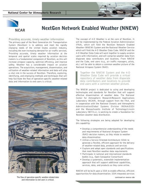
National Center for Atmospheric Research<br />
<strong>NextGen</strong> <strong>Network</strong> <strong>Enabled</strong> <strong>Weather</strong> (<strong>NNEW</strong>)<br />
Providing accurate, timely weather information<br />
The primary goal of the Next Generation Air Transportation<br />
System (<strong>NextGen</strong>) is to address and meet the rapidly<br />
changing needs of the United States aviation industry,<br />
including the ever-increasing demand for air traffic services.<br />
Providing accurate, timely weather information at the<br />
temporal and spatial scales required by aviation decision<br />
makers is a fundamental component of <strong>NextGen</strong>, as this will<br />
increase airspace capacity, optimize efficiency, and improve<br />
safety. <strong>Weather</strong> has a considerable impact on aviation<br />
operations. The acquisition, management, dissemination, and<br />
utilization of weather-related information and data will play<br />
a vital role in the success of <strong>NextGen</strong>. Therefore, exploring,<br />
identifying, and employing methods and techniques that will<br />
help facilitate the flow of operation-specific weather-related<br />
data and information to end users is critical.<br />
The concept of 4-D <strong>Weather</strong> is at the core of <strong>NextGen</strong>. It<br />
will be implemented by the Federal Aviation Administration<br />
(FAA), which will field the <strong>NextGen</strong> <strong>Network</strong> <strong>Enabled</strong><br />
<strong>Weather</strong> (<strong>NNEW</strong>) System and the National <strong>Weather</strong> Service<br />
which will field the 4-D <strong>Weather</strong> Data Cube. <strong>NNEW</strong> and the<br />
4-D <strong>Weather</strong> Data Cube will work together to supply aviation<br />
users with information, and will comprise weather data from<br />
disparate data contributors and locations. From <strong>NNEW</strong><br />
and the Cube, end users (e.g., air traffic managers, pilots,<br />
etc.) will be able to obtain a common weather picture of the<br />
National Airspace System (NAS).<br />
Together the <strong>NNEW</strong> System and the 4-D<br />
<strong>Weather</strong> Data Cube will provide a virtual<br />
repository of weather data from disparate<br />
data contributors and locations to provide<br />
end users with a common weather picture.<br />
The <strong>NNEW</strong> project is dedicated to using and developing<br />
technologies and standards for <strong>NextGen</strong> that will support<br />
effective dissemination of weather data. The National<br />
Center for Atmospheric Research/Research Applications<br />
Laboratory (NCAR), through support from the FAA, and<br />
in cooperation with the National Oceanic and Atmospheric<br />
Administration/Global Systems Division (NOAA/GSD)<br />
and the Massachusetts Institute of Technology/Lincoln<br />
Laboratory (MIT/LL), is working to create a foundation for<br />
<strong>NextGen</strong> weather data distribution.<br />
The following strategies are being adopted for developing<br />
this capability:<br />
• Develop a comprehensive understanding of the needs<br />
and requirements of National Airspace System<br />
(NAS) decision makers, as they relate to weather<br />
data dissemination<br />
• Utilize a Service Oriented Architecture (SOA) to<br />
generate a flexible, efficient approach for the delivery<br />
of weather-related data, products and services<br />
• Explore and adopt open standards and specifications<br />
that meet <strong>NextGen</strong> weather data requirements<br />
• Participate in national and international standards<br />
bodies (e.g., Open Geospatial Consortium)<br />
• Develop a systematic, extensible implementation<br />
approach that will support additional capabilities,<br />
services, data, and products as they come online.<br />
The flow of operation-specific weather-related data<br />
and information to end users is critical.<br />
<strong>NNEW</strong> will be built upon a SOA to enable effective, efficient<br />
opportunities for data dissemination. SOA integrates services<br />
continued on reverse side
(applications) running on heterogeneous platforms using<br />
common standards (e.g.,HTTP, SOAP, XML, etc.). In the case<br />
of <strong>NNEW</strong>, service-orientation focus is on service interfaces,<br />
with no requirement to use particular implementations<br />
of those interfaces. The SOA concept facilitates data<br />
exchange, as well as interactions in support of an outcome<br />
(e.g., product generation). Services are well-defined, selfcontained,<br />
and do not necessarily depend on the state of<br />
other services. Standards and specifications developed and/<br />
or used by <strong>NNEW</strong> will be layered on top of ‘core’ services<br />
provided by the FAA System-Wide Information Management<br />
(SWIM) program. Both <strong>NNEW</strong> and SWIM will in turn be<br />
layered on top of the FAA Telecommunication Infrastructure<br />
(FTI), the basic network connectivity layer.<br />
The primary objective of <strong>NNEW</strong> is to provide flexible,<br />
scalable open architecture and standards that will enable the<br />
seamless aggregation of data and services to support data<br />
discovery and acquisition by NAS decision makers.<br />
For More Information, Contact:<br />
Bob Barron<br />
National Center for Atmospheric Research (NCAR)<br />
Research Applications Laboratory<br />
PO Box 3000 Boulder CO 80307-3000<br />
303-497-8410 303-497-8401 fax<br />
bob@ucar.edu www.ral.ucar.edu<br />
Flow of weather information<br />
WEATHER HAZARD INFORMATION (4-D) | DATA AND OBSERVATIONS<br />
Storms and convection<br />
Turbulence In-flight icing Ceiling and visibility Surface observations<br />
Aircraft observations<br />
PROTOCOLS<br />
• SOAP • ebXML<br />
• WCS • WFS<br />
STANDARD PROTOCOLS AND FORMATS<br />
FORMATS<br />
• NetCDF • GRIB<br />
• GML/XML<br />
WEB SERVICES<br />
REGISTRY/REPOSITORY<br />
DATA<br />
<strong>NNEW</strong> and the<br />
4-D <strong>Weather</strong> Data Cube<br />
REGISTRY/REPOSITORY<br />
WEB SERVICES<br />
DATA<br />
PROTOCOLS<br />
• SOAP • ebXML<br />
• WCS • WFS<br />
STANDARD PROTOCOLS AND FORMATS<br />
FORMATS<br />
• NetCDF • GRIB<br />
• GML/XML<br />
DECISION SUPPORT TOOLS AND SYSTEMS<br />
Storm prediction<br />
Icing<br />
Flight Path Tool (FPT)<br />
Turbulence<br />
Meteogram<br />
Next Generation<br />
Air Transport System (<strong>NextGen</strong>)