National Cycle Network Go Traffic Free in Scotland - Sustrans
National Cycle Network Go Traffic Free in Scotland - Sustrans
National Cycle Network Go Traffic Free in Scotland - Sustrans

Create successful ePaper yourself
Turn your PDF publications into a flip-book with our unique Google optimized e-Paper software.
Forth Road Bridge & Dalmeny<br />
<strong>National</strong> <strong>Cycle</strong> <strong>Network</strong><br />
<strong>Go</strong> <strong>Traffic</strong> <strong>Free</strong><br />
<strong>in</strong> <strong>Scotland</strong><br />
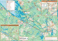
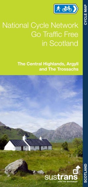
The Central Highlands, Argyll<br />
and The Trossachs<br />
SCOTLAND CYCLE MAP
Overview<br />
Use this booklet to follow safe and attractive walk<strong>in</strong>g<br />
and cycl<strong>in</strong>g options <strong>in</strong> the Central Highlands, Argyll,<br />
and The Trossachs. It shows the ma<strong>in</strong> traffic-free<br />
sections on the <strong>National</strong> <strong>Cycle</strong> <strong>Network</strong>, Regional<br />
Routes and key local routes. Use it to plan your<br />
(carbon-free) trips around and out of town. See how<br />
far and easily you can travel without a car.<br />
For <strong>in</strong>formation on cycle routes across <strong>Scotland</strong>,<br />
see <strong>Sustrans</strong>’ Routes2Ride website – you can also<br />
add your own routes, comments and photos.<br />
www.routes2ride.org.uk/scotland<br />
Use Ordnance Survey maps to plan your own<br />
routes. Contact the relevant local authorities for<br />
more <strong>in</strong>formation on cycl<strong>in</strong>g routes <strong>in</strong> each area.<br />
How to use this booklet<br />
This booklet highlights walk<strong>in</strong>g and cycl<strong>in</strong>g routes <strong>in</strong> the follow<strong>in</strong>g<br />
areas:<br />
1<br />
Inverness, Aviemore and Drumochter<br />
Fort William to Fort Augustus<br />
Argyll – the Lochgilphead area<br />
The Trossachs and Glen Ogle<br />
Each detailed map uses the follow<strong>in</strong>g key<br />
Featured route<br />
<strong>National</strong> <strong>Cycle</strong> <strong>Network</strong> traffic-free<br />
<strong>National</strong> <strong>Cycle</strong> <strong>Network</strong> on-road<br />
Other route<br />
Proposed cycle route<br />
Railway (station)<br />
Access po<strong>in</strong>t<br />
Take care po<strong>in</strong>t / section<br />
Steep hill / One way<br />
Caravan site / Campsite /<br />
Youth hostel<br />
Public house<br />
Cafe / Shop<br />
Bike Shop<br />
Birdwatch<strong>in</strong>g<br />
Public toilets<br />
Post office<br />
Tourist Information<br />
Castle Tourist attraction<br />
Signalled cross<strong>in</strong>g<br />
p18<br />
p24<br />
p26<br />
Time: The time given to complete a route is calculated on<br />
an average travell<strong>in</strong>g time of 7 miles or 11 km per hour. This<br />
allows for a leisurely cycl<strong>in</strong>g pace or for plenty of stops. Times<br />
and distances given for l<strong>in</strong>ear routes are for one way only.<br />
p4<br />
<strong>Go</strong>od Cycl<strong>in</strong>g Code<br />
Obey the rules of the road<br />
Be courteous<br />
l Give way to pedestrians<br />
l Remember that some people are hard of hear<strong>in</strong>g or visually<br />
impaired<br />
l Where there are wheelchair users or horse riders, please<br />
give way<br />
l R<strong>in</strong>g a bell <strong>in</strong> good time or politely call out to warn of your<br />
approach<br />
Care for the environment<br />
l Can you reach the start of your journey by bike or public<br />
transport?<br />
l Follow the Scottish Outdoor Access Code; <strong>in</strong> particular,<br />
do not damage crops, don’t disturb livestock or wildlife and<br />
always take litter home<br />
Look after yourself<br />
l Take care at junctions, when cycl<strong>in</strong>g downhill and on loose or<br />
wet surfaces<br />
l In remote areas carry food, water, repair kit, map and<br />
waterproofs<br />
l Keep your bike roadworthy; use lights <strong>in</strong> poor visibility<br />
l Consider wear<strong>in</strong>g a helmet and conspicuous cloth<strong>in</strong>g<br />
Us<strong>in</strong>g public transport<br />
Why not use the tra<strong>in</strong> to carry you and your bike further afield or<br />
to take you home after a cycle? Bicycles can be carried on most<br />
tra<strong>in</strong>s, but it is advisable to check <strong>in</strong> advance and book a place<br />
as space is limited. For rail <strong>in</strong>formation call 08457 48 49 50 or<br />
visit www.thetra<strong>in</strong>l<strong>in</strong>e.co.uk. Bicycles can be carried on Cityl<strong>in</strong>k<br />
coaches, but they must be bagged or boxed. Check before<br />
travell<strong>in</strong>g. Phone 08705 50 50 50 or visit www.cityl<strong>in</strong>k.co.uk.<br />
For <strong>in</strong>formation on all public transport with<strong>in</strong> <strong>Scotland</strong>, call<br />
0871 200 22 33 or visit www.travel<strong>in</strong>escotland.com.<br />
Scottish Outdoor Access Code<br />
Know the Code before you go …<br />
Enjoy <strong>Scotland</strong>’s outdoors - responsibly!<br />
Everyone has the right to be on most<br />
land and <strong>in</strong>land water provid<strong>in</strong>g they<br />
act responsibly. Your access rights and responsibilities<br />
are expla<strong>in</strong>ed fully <strong>in</strong> the Scottish Outdoor Access Code.<br />
Whether you’re <strong>in</strong> the outdoors or manag<strong>in</strong>g the outdoors, the<br />
key th<strong>in</strong>gs are to:<br />
l take responsibility for your own actions;<br />
l respect the <strong>in</strong>terests of other people;<br />
l care for the environment.<br />
F<strong>in</strong>d out more by visit<strong>in</strong>g www.outdooraccess-scotland.com<br />
or phon<strong>in</strong>g your local Scottish Natural Heritage office.<br />
2
Inverness, Aviemore and Drumochter<br />
Inverness<br />
Culloden<br />
Nairn<br />
Inverness to Culloden<br />
Ness Islands to Dochgarroch<br />
Calv<strong>in</strong>e to Dalwh<strong>in</strong>nie<br />
Dalwh<strong>in</strong>nie to K<strong>in</strong>gussie<br />
Aviemore to Boat of Garten<br />
Boat of Garten to Slochd<br />
p6<br />
p8<br />
p10<br />
p12<br />
p14<br />
p16<br />
Highland <strong>Cycle</strong> Bus<br />
If you want to head to the North West Highlands, the Highland<br />
<strong>Cycle</strong> Bus (and Trailer) operates between Inverness and Durness<br />
via Ullapool from April to September. The bus can carry up to<br />
15 bikes and is available for private hire. For more <strong>in</strong>formation,<br />
phone 01349 883585 or see www.timdearmancoaches.co.uk<br />
Monadhliath<br />
Mounta<strong>in</strong>s<br />
Carrbridge<br />
Boat of<br />
Garten<br />
Aviemore<br />
Miles<br />
0<br />
5 10 15<br />
0 5 10 15 20 25<br />
Kilometres<br />
K<strong>in</strong>craig<br />
Cairngorm<br />
Mounta<strong>in</strong>s<br />
K<strong>in</strong>gussie<br />
On-road <strong>National</strong> <strong>Cycle</strong> <strong>Network</strong> section<br />
<strong>Traffic</strong>-free <strong>National</strong> <strong>Cycle</strong> <strong>Network</strong> section<br />
Newtonmore<br />
Other routes<br />
Time: The time given to complete a route is calculated on an<br />
average travell<strong>in</strong>g time of 7 miles or 11 km per hour. This<br />
allows for a leisurely cycl<strong>in</strong>g pace or for plenty of stops. Times<br />
and distances given for l<strong>in</strong>ear routes are for one way only.<br />
Dalwh<strong>in</strong>nie<br />
Whilst every effort has been made to achieve accuracy of<br />
<strong>in</strong>formation <strong>in</strong> this booklet at time of publication, <strong>Sustrans</strong><br />
can take no responsibility for: loss or <strong>in</strong>jury (<strong>in</strong>clud<strong>in</strong>g fatal) to<br />
persons; loss of damage to property or equipment; trespass,<br />
irresponsible rid<strong>in</strong>g or any other mishap that may be suffered as<br />
a result of follow<strong>in</strong>g route descriptions <strong>in</strong> this booklet.<br />
Map and text © <strong>Sustrans</strong> 2009<br />
Maps are reproduced from Ordnance Survey material with the permission<br />
of Ordnance Survey on behalf of the Contoller of Her Majesty’s Stationery<br />
Office © Crown copyright. Unauthorised reproduction <strong>in</strong>fr<strong>in</strong>ges Crown<br />
copyright and may lead to prosecution or civil proceed<strong>in</strong>gs.<br />
Licence number 100020852<br />
3<br />
Calv<strong>in</strong>e<br />
Blair Atholl<br />
4
B861<br />
Inverness to Culloden 1<br />
B916<br />
To D<strong>in</strong>gwall, Cromarty<br />
and John o’Groats<br />
A96<br />
Charlestown<br />
Beauly<br />
Firth<br />
Map 2<br />
A9<br />
North<br />
Kessock<br />
Dolph<strong>in</strong> and<br />
Seal Centre<br />
Craigton<br />
Moray<br />
Firth<br />
One of the impressive Clava Cairns © Fergal MacErlean<br />
A96<br />
Balloch<br />
Culloden<br />
A9<br />
A862<br />
Caledonian<br />
Canal<br />
Inverness<br />
Station<br />
Inverness Museum<br />
and Art Gallery<br />
(Museums Galleries <strong>Scotland</strong>)<br />
Inverness<br />
Inverness<br />
Castle<br />
Inverness Cathedral<br />
A862<br />
A82<br />
A82<br />
B862<br />
B862<br />
A8<br />
B853<br />
Start/<br />
F<strong>in</strong>ish<br />
B865<br />
B9006<br />
B9006<br />
A9<br />
A96<br />
B9006<br />
Smithton<br />
Westhill<br />
B9006<br />
Culloden<br />
Muir<br />
Culloden Visitor Centre<br />
Culloden Battlefield 1746<br />
(<strong>National</strong> Trust for <strong>Scotland</strong>)<br />
Newlands<br />
Start/<br />
F<strong>in</strong>ish<br />
B9 006<br />
To Nairn, Elg<strong>in</strong><br />
and Aberdeen<br />
Great Glen<br />
Way<br />
B862<br />
B8082<br />
A9<br />
A82<br />
B862<br />
River Ness<br />
B8082<br />
Miles<br />
0 1 2<br />
0 1 2 3<br />
Kilometres<br />
Category: Ma<strong>in</strong>ly on-road, some cycle path<br />
Distance: 8 miles/13 kilometres<br />
Time: 1 hour 15 m<strong>in</strong>utes<br />
Gradient: Susta<strong>in</strong>ed climb from Balloch to Newlands, otherwise<br />
fairly flat<br />
Surface: Tarmac, some wh<strong>in</strong> dust<br />
B861<br />
B8082<br />
B9177<br />
B851<br />
To Aviemore,<br />
Pitlochry and<br />
Glasgow<br />
Leave the friendly Highland capital of Inverness to cycle by some<br />
remarkable historical sights. The route heads east, with a variety<br />
of on-road cycle lanes and quiet residential sections, before<br />
climb<strong>in</strong>g away from the Moray Firth.<br />
At the Newlands crossroads it’s worth divert<strong>in</strong>g right for 200<br />
yards to the Culloden battlefield site and newly renovated visitor<br />
centre. Scottish history was written here <strong>in</strong> April 1746 when the<br />
Jacobites were routed by government forces. Decades of<br />
Highland oppression ensued.<br />
Back on the bike, cont<strong>in</strong>ue to the magnificent Clava Cairns. This<br />
collection of well preserved Bronze Age cairns and passage<br />
graves stand timeless <strong>in</strong> a tranquil open sett<strong>in</strong>g. Those with an<br />
<strong>in</strong>terest <strong>in</strong> archaeology, or who are simply curious about our<br />
ancestors, will be absorbed.<br />
If you head north across the Kessock Bridge, you can follow<br />
Route 1 for 14 miles to D<strong>in</strong>gwall us<strong>in</strong>g a comb<strong>in</strong>ation of quiet<br />
roads and new cycleway alongside the A835 between Tore and<br />
Maryburgh.<br />
5<br />
6
Ness Islands to Dochgarroch 2<br />
Map 1<br />
Category: Canal towpath<br />
Distance: 5 miles/8 kilometres<br />
Time: 50 m<strong>in</strong>utes<br />
Gradient: Flat<br />
Surface: Tarmac, smooth earthen/gravel surface<br />
Explore the Caledonian Canal on this peaceful cycle<br />
from Inverness. To get to the canal, follow the River Ness<br />
upstream, branch<strong>in</strong>g right on to Ness Bank. Where this<br />
road curves away from the river at the suspension bridge,<br />
keep straight on the riverside path.<br />
Cont<strong>in</strong>ue until you reach a narrow bridge and follow the<br />
Great Glen Way (GGW) signs onto the Ness Islands.<br />
Follow the GGW signs along the path across these green,<br />
wooded islands to the far river bank. Turn left and follow<br />
the track or quiet Bucht Road to Wh<strong>in</strong> Park where there<br />
is a childrens’ play park, boat<strong>in</strong>g pond, refreshments and<br />
toilets.<br />
Carry on up the road to Tomnahurich Bridge, where you<br />
leave the GGW. Don’t cross the bridge, but turn sharp<br />
left onto the canal towpath. From here enjoy a perfect<br />
family-friendly ride along the east side of the canal – at<br />
some po<strong>in</strong>ts you can see the canal to one side and the<br />
River Ness to the other. The ride ends at Dochgarroch<br />
Lock where there is a picnic spot and a café nearby.<br />
K<strong>in</strong>mylies<br />
Great Glen<br />
Way<br />
Dalneigh<br />
Tomnahurich Bridge<br />
Merk<strong>in</strong>ch<br />
A862<br />
Play<br />
Park<br />
Footbridge<br />
Inverness Museum<br />
and Art Gallery<br />
A82<br />
A82<br />
Bught Park<br />
Sports<br />
Centre<br />
N e s s I s l a n d s<br />
Inverness<br />
Cathedral<br />
Footbridge<br />
BLIGHT ROAD<br />
Start/<br />
F<strong>in</strong>ish<br />
Inverness<br />
Station<br />
B861<br />
Drummond<br />
Castle<br />
Inverness<br />
B865<br />
Crown<br />
B853<br />
Hilton<br />
Duna<strong>in</strong><br />
B862<br />
Lochardil<br />
A82<br />
Miles<br />
0 0.5<br />
0<br />
Kilometres<br />
7<br />
Dochgarroch<br />
Lock<br />
Start/<br />
F<strong>in</strong>ish<br />
0.5<br />
1<br />
Caledonian Canal<br />
River Ness<br />
Be a considerate cyclist<br />
●● Avoid cycl<strong>in</strong>g where your tyres will damage the<br />
path or verges<br />
●● Give way to others on the towpath and warn<br />
them of your approach<br />
●● For more <strong>in</strong>formation contact British Waterways<br />
on 01923 201120 or www.waterscape.com<br />
Start/<br />
F<strong>in</strong>ish<br />
8
Calv<strong>in</strong>e to Dalwh<strong>in</strong>nie 3<br />
Dalwh<strong>in</strong>nie<br />
Dalwh<strong>in</strong>nie<br />
Start/<br />
F<strong>in</strong>ish<br />
Loch<br />
Ericht<br />
Map 4<br />
The Cairngorms <strong>National</strong><br />
Park - Brita<strong>in</strong>’s largest and<br />
newest national park.<br />
www.cairngorms.co.uk<br />
Cairngorms<br />
<strong>National</strong> Park<br />
A9<br />
North<br />
Drumochter<br />
Lodge<br />
Grampian Mounta<strong>in</strong>s<br />
Drumochter Pass<br />
Look<strong>in</strong>g west from the high Drumochter Pass © Fergal MacErlean<br />
Miles<br />
0 1 2<br />
Loch<br />
Garry<br />
Dalnaspidal Lodge<br />
Surfaces can be loose over this sections<br />
Category: Upland cycle path<br />
Distance: 17 miles/27 kilometres<br />
Time: 3 hours<br />
Gradient: A long <strong>in</strong>cl<strong>in</strong>e with a total ascent of 665 metres<br />
Surface: Tarmac and wh<strong>in</strong> dust<br />
Try an excit<strong>in</strong>g section of <strong>National</strong> Route 7 as it crosses the<br />
Drumochter Pass. It’s the ultimate route north with long sections<br />
of purpose built off-road cycle path and m<strong>in</strong>or roads that carry<br />
only occasional local traffic.<br />
The start, <strong>in</strong> the hamlet of Calv<strong>in</strong>e, is marked by a drum<br />
sculpture, which is apt as your heart will be beat<strong>in</strong>g loudly as you<br />
climb to the 1508-foot-high pass. Along the way there are jaw<br />
dropp<strong>in</strong>g views down Loch Garry as it disappears mysteriously<br />
<strong>in</strong>to the hills. From the top of the pass, the reward is a five-mile<br />
downhill run to Dalwh<strong>in</strong>nie.<br />
A9<br />
Start of the Gaick Pass - a test<strong>in</strong>g mounta<strong>in</strong><br />
bike route (with river cross<strong>in</strong>gs) to Speyside.<br />
Use OS Landranger maps 35 & 42<br />
Dalnacardoch<br />
Lodge<br />
Dalnacardoch<br />
Wood<br />
Dalname<strong>in</strong><br />
Lodge<br />
Elrig na Curig<strong>in</strong><br />
0 1 2 3<br />
Kilometres<br />
Clunes Lodge<br />
B847<br />
Old Military Road<br />
House of Bruar<br />
Start/<br />
F<strong>in</strong>ish<br />
Calv<strong>in</strong>e<br />
Balua<strong>in</strong> Wood<br />
To Pitlochry<br />
and Glasgow<br />
9<br />
10
A889<br />
Dalwh<strong>in</strong>nie to K<strong>in</strong>gussie 4<br />
Craigbui<br />
Wood<br />
Category: Quiet road and cycle path<br />
Distance: 13 miles/21 kilometres<br />
Time: 2 hours<br />
Gradient: Initial short climb, thereafter downhill<br />
and flat<br />
Surface: Tarmac<br />
With the heady smells from the Dalwh<strong>in</strong>nie<br />
Distillery waft<strong>in</strong>g <strong>in</strong> your nostrils, this route, through<br />
heathery Glen Truim <strong>in</strong> the Cairngorms <strong>National</strong><br />
Park, will leave you <strong>in</strong>toxicated.<br />
After an <strong>in</strong>itial climb from Dalwh<strong>in</strong>nie, Glen Truim<br />
offers perfect cycl<strong>in</strong>g on a quiet, gently undulat<strong>in</strong>g<br />
road. The elevated position gives good views of the<br />
glacially smoothed Grampian Mounta<strong>in</strong>s.<br />
After the Falls of Truim, the route follows the old A9<br />
to reach Newtonmore. The cont<strong>in</strong>uation to nearby<br />
K<strong>in</strong>gussie is on an excellent family friendly off-road<br />
cycle path. Both of these villages have a long and<br />
proud history, which is recounted <strong>in</strong><br />
their respective Highland Folk Museums.<br />
To Laggan Wolftrax<br />
Mounta<strong>in</strong> Bik<strong>in</strong>g<br />
Coille na<br />
Creige Duibhe<br />
A86<br />
Ralia<br />
Newtonmore<br />
Highland<br />
Folk<br />
Museum<br />
K<strong>in</strong>gussie<br />
A9<br />
Use the counterflow cycleway<br />
on this short section of road<br />
Start/<br />
F<strong>in</strong>ish<br />
Highland<br />
Folk<br />
Museum<br />
B9152<br />
Ruthven<br />
Barracks<br />
Coille an<br />
Torra Chrualdh<br />
To Aviemore<br />
Ma<strong>in</strong>s of<br />
Glentruim<br />
Falls of Truim<br />
Etteridge<br />
Miles<br />
0 1<br />
0 1 2<br />
Kilometres<br />
3<br />
2<br />
To Laggan<br />
Glen Truim<br />
Cairngorms<br />
<strong>National</strong><br />
Park<br />
11<br />
Dalwh<strong>in</strong>nie<br />
Distillery<br />
Dalwh<strong>in</strong>nie<br />
Dalwh<strong>in</strong>nie<br />
Start/<br />
F<strong>in</strong>ish<br />
Map 3 Sculptures at the Highland Folk Museum © Fergal MacErlean 12
Aviemore to Boat of Garten 5<br />
Map 6<br />
Category: Off-road cycle path<br />
Distance: 4 miles/7 kilometres<br />
Time: 30 m<strong>in</strong>utes<br />
Gradient: Gently undulat<strong>in</strong>g<br />
Surface: Ma<strong>in</strong>ly gravel path<br />
A95(T)<br />
The Strathspey Railway<br />
(Tra<strong>in</strong>s run Easter to October)<br />
Boat of Garten<br />
Start/<br />
F<strong>in</strong>ish<br />
To Grantown<br />
-on-Spey<br />
B970<br />
Speyside Way<br />
This is a wonderful off-road route where you can<br />
forget all about traffic and soak up the mounta<strong>in</strong><br />
scenery. It follows an off-road variant of <strong>National</strong><br />
Route 7 and passes through heather moorland,<br />
p<strong>in</strong>e forest, and lichen-rich birch woods.<br />
Street of<br />
K<strong>in</strong>card<strong>in</strong>e<br />
Access the route from the southern end of<br />
Aviemore, the tra<strong>in</strong> station, or off the ma<strong>in</strong> street,<br />
and turn left along a m<strong>in</strong>or road. After go<strong>in</strong>g<br />
through a hous<strong>in</strong>g estate the route leaves the<br />
town beh<strong>in</strong>d: views of the Cairngorm’s deep<br />
northern corries open up on the right. Cont<strong>in</strong>ue<br />
to jo<strong>in</strong> a very quiet road for the f<strong>in</strong>al mile which<br />
leads easily through Scots p<strong>in</strong>e to the attractive<br />
village of Boat of Garten, the Osprey village.<br />
A9(T)<br />
A95(T)<br />
Avie<br />
Lochan<br />
Loch pan<br />
Carraigean<br />
Strathspey Steam The Railway<br />
Speyside Way<br />
Lochan Dubh<br />
Loch Dallas<br />
West<br />
Croftmore<br />
Auchgourish<br />
B970<br />
River Spey<br />
Pityoulish<br />
Loch<br />
Pityoulish<br />
Aviemore Visitor Centre<br />
(Cairngorms <strong>National</strong> Park)<br />
A9(T)<br />
Start/<br />
F<strong>in</strong>ish<br />
Dalfaber<br />
Aviemore<br />
Miles<br />
0 1<br />
Craigellachie <strong>National</strong> Nature Reserve<br />
(Scottish Natural Heritage)<br />
2<br />
Aviemore Station<br />
The Strathspey Railway<br />
(Tra<strong>in</strong>s run Easter to October)<br />
0<br />
Kilometres<br />
1 2<br />
3<br />
B9152<br />
Nordic Ski<br />
Centre<br />
Inverdruie<br />
Hotel<br />
Coylumbridge<br />
Mounta<strong>in</strong> Rescue<br />
Post<br />
B970<br />
A9(T)<br />
Doune of Rothiemurchus<br />
(Historic Houses Association)<br />
Rothiemurchus Estate<br />
Mounta<strong>in</strong> bike tracks<br />
The Old Logg<strong>in</strong>g Way<br />
(to Glenmore)<br />
To Cairngorm<br />
Mounta<strong>in</strong><br />
Loch Alvie<br />
B970<br />
13<br />
B9152<br />
To Pitlochry<br />
and Glasgow<br />
Loch<br />
Morlich<br />
14
Boat of Garten to Slochd 6<br />
Category: Off-road forest cycle path<br />
Distance: 10 miles/16 kilometres<br />
Time: 2-3 hours<br />
Gradient: Hilly<br />
Surface: Ma<strong>in</strong>ly stony paths; two-mile on-road section.<br />
Mounta<strong>in</strong> bikes recommended<br />
Miles<br />
0 1<br />
2<br />
0<br />
Kilometres<br />
1 2<br />
3<br />
To<br />
Inverness<br />
Slochd<br />
Ski Centre, bunkhouse<br />
and cycle hire<br />
The old bridge at Carrbridge stands strong © Fergal MacErlean<br />
Baddengorm<br />
Woods<br />
A938<br />
A9(T)<br />
Start/<br />
F<strong>in</strong>ish<br />
Carn Bad<br />
nan Luibhean<br />
Inverlaidnan<br />
Hill<br />
General Wade’s<br />
Military Road<br />
Expect variable surfaces<br />
Sluggan<br />
Bridge<br />
A<br />
938<br />
Carrbridge<br />
Station<br />
A938<br />
Historic<br />
Bridge<br />
Glencharnoch<br />
Wood<br />
(Woodland Trust)<br />
A9(T)<br />
Carrbridge<br />
B9153<br />
Landmark<br />
Centre<br />
River Dulna<strong>in</strong><br />
Expect variable surfaces<br />
From Boat of Garten the route follows a dedicated paved and flat<br />
cyclepath, which runs separate from and parallel to the road;<br />
open heather-covered moorland extends to the right. After 1¼<br />
miles, cross the A95 to follow the off-road variant of <strong>National</strong><br />
Route 7 to Carrbridge.<br />
B9153<br />
Docharn<br />
Craig<br />
Docharn<br />
In Carrbridge take the off-road route for Slochd, pass<strong>in</strong>g<br />
Carrbridge’s wonderfully antiquated humpbacked bridge. The<br />
<strong>in</strong>itial section follows a quiet m<strong>in</strong>or road before branch<strong>in</strong>g off<br />
through beautiful birch woods to descend to the restored,<br />
grass-covered Sluggan Bridge. From here enjoy cycl<strong>in</strong>g through<br />
Scots p<strong>in</strong>e to arrive by Slochd Mhór Lodge (bunkhouse) and<br />
cycle shop. Another 1.5 miles takes you to Slochd Summit, where<br />
the cycle track runs between the railway and the A9 through a<br />
narrow pass.<br />
A95(T)<br />
The Strathspey Railway<br />
(Tra<strong>in</strong>s run Easter to October)<br />
Boat of Garten<br />
Start/<br />
F<strong>in</strong>ish<br />
15<br />
Map 5<br />
16
Fort William to Fort Augustus<br />
The Great Glen Way runs for 73 miles/117 km<br />
between Fort William and Inverness. Cyclists:<br />
please show consideration to walkers on the<br />
route – make them aware of your approach and slow down when<br />
pass<strong>in</strong>g. For more <strong>in</strong>formation on the route, contact the Great<br />
Glen Way rangers on 01320 366 633; email greatglenway@<br />
highland.gov.uk or see www.greatglenway.com<br />
Fort Augustus<br />
Great Glen Way<br />
Loch<br />
Ness<br />
Miles<br />
0<br />
5 10<br />
Bridge of Oich<br />
0<br />
Kilometres<br />
5 10 15<br />
Loch Garry<br />
Invergarry<br />
Loch Oich<br />
On-road <strong>National</strong> <strong>Cycle</strong> <strong>Network</strong> section<br />
<strong>Traffic</strong>-free <strong>National</strong> <strong>Cycle</strong> <strong>Network</strong> section<br />
Corpach<br />
Loch<br />
L<strong>in</strong>nhe<br />
17<br />
Great Glen Way<br />
Caledonian Canal<br />
Lock<br />
Loch Arkaig<br />
Laggan<br />
Gairlochy<br />
Fort William<br />
Clunes<br />
Loch Lochy<br />
Great Glen Way Great Glen Way<br />
Laggan<br />
See <strong>in</strong>set for more detail<br />
Other routes<br />
Time: The time given to complete a route<br />
is calculated on an average travell<strong>in</strong>g time<br />
of 7 miles or 11 km per hour. This allows<br />
for a leisurely cycl<strong>in</strong>g pace or for plenty of<br />
stops. Times and distances given for<br />
l<strong>in</strong>ear routes are for one way only.<br />
Fort William to Gairlochy<br />
Bridge of Oich to Fort Augustus<br />
Great Glen <strong>Cycle</strong><br />
p20<br />
p22<br />
This is an attractive and mostly flat 32-mile traffic-free route from<br />
Fort William to Fort Augustus. Maps 7 and 8 show both ends of<br />
the route <strong>in</strong> more detail.<br />
The middle section runs from Gairlochy to Bridge of Oich<br />
(19miles/31km). From the end of the canal at Gairlochy follow the<br />
Great Glen Ways (GGW) signs along the quiet B8005 to Clunes<br />
and then a forest road and m<strong>in</strong>or public road to Laggan.<br />
At Laggan you have a choice of routes. You can cont<strong>in</strong>ue on the<br />
m<strong>in</strong>or public road north of the canal and then on a steep forest<br />
road to Invergarry. Cont<strong>in</strong>ue on the GGW through the forest to<br />
Bridge of Oich (7½ miles). Alternatively, cross the canal at<br />
Laggan Locks (good picnic spot). Take care cross<strong>in</strong>g the ma<strong>in</strong><br />
road, turn right and immediately left onto a steep path up<br />
through trees to the disused railway l<strong>in</strong>e. As the route reaches<br />
Loch Oich, it descends to the old military road and then sw<strong>in</strong>gs<br />
left at the northern end of the loch towards Bridge of Oich. The<br />
path is rough and muddy <strong>in</strong> places and you may have to lift your<br />
bike over gates <strong>in</strong> a couple of places (6¼ miles).<br />
Note<br />
This route is part of the proposed <strong>National</strong> Route 78 between<br />
Fort William and Inverness.<br />
18
Fort William to Gairlochy 7<br />
Category: <strong>Cycle</strong> track and canal towpath<br />
Distance: 10 miles/16 kilometres<br />
Time: 1 hour 30 m<strong>in</strong>utes<br />
Gradient: Flat<br />
Surface: Wh<strong>in</strong> dust<br />
Explore the western end of the Great Glen<br />
along the banks of the Caledonian Canal. This<br />
is a great family-friendly cycle with marvellous<br />
views of the north face of Ben Nevis. The route<br />
starts from the centre of Fort William - from the<br />
tra<strong>in</strong> station take an off-road path beh<strong>in</strong>d the<br />
supermarket. Quiet streets lead to a footbridge<br />
over the river near Inverlochy Castle. Follow<br />
cycle lanes along the B8006 and turn left onto<br />
a shore path and follow it round to Neptune’s<br />
Staircase (take care cross<strong>in</strong>g the A830). This<br />
route affords memorable views right down<br />
Loch L<strong>in</strong>nhe.<br />
Neptune’s Staircase – a photogenic flight of<br />
eight locks, which raises vessels to 70 feet<br />
above sea level – is equally memorable.<br />
Cont<strong>in</strong>ue on the eastern towpath to cycle easily<br />
along to Gairlochy where this section of the<br />
canal ends and Loch Lochy beg<strong>in</strong>s.<br />
Muirshearlich<br />
Glen Loy<br />
B8004<br />
To Fort Augustus<br />
Caledonian Canal<br />
Miles<br />
0<br />
0<br />
Kilometres<br />
Gairlochy<br />
Great Glen Way<br />
B8005<br />
Start/<br />
F<strong>in</strong>ish<br />
1 2<br />
1 2<br />
3<br />
Note<br />
This route is part of the proposed <strong>National</strong><br />
Route 78 between Fort William and Inverness.<br />
Caledonian Canal<br />
Torcastle<br />
Great Glen Way<br />
Nevis Range Mounta<strong>in</strong><br />
Bike Centre<br />
Corpach<br />
Corpach<br />
Station<br />
Neptune's<br />
Staircase<br />
A830<br />
B8006<br />
Caol<br />
A82<br />
Loch L<strong>in</strong>nhe<br />
Inverlochy Castle<br />
(Historic <strong>Scotland</strong>)<br />
Start/<br />
F<strong>in</strong>ish<br />
Claggan<br />
19<br />
Fort William<br />
Station<br />
Fort William<br />
West Highland Museum<br />
(Museums Galleries <strong>Scotland</strong>)<br />
Neptune’s Staircase by Corpach © Fergal MacErlean<br />
20
Bridge of Oich to Fort Augustus 8<br />
Those with an aversion to hills will love this flat route<br />
which follows the Caledonian Canal from the head of<br />
Loch Oich. Jo<strong>in</strong> the towpath by the Aberchalder<br />
Sw<strong>in</strong>g Bridge to enjoy effortless traffic-free cycl<strong>in</strong>g.<br />
The River Oich runs alongside for much of the<br />
towpath’s length, giv<strong>in</strong>g a watery feel<strong>in</strong>g to this<br />
out<strong>in</strong>g. On the right, rise the steep slopes of the<br />
Great Glen formed by a tear fault <strong>in</strong> the Earth’s crust.<br />
Cont<strong>in</strong>ue to enter bustl<strong>in</strong>g Fort Augustus where the<br />
canal descends through five locks to enter Loch<br />
Ness. Among the many attractions is the Caledonian<br />
Canal Visitor Centre, which details the waterway’s<br />
history up to its present day rejuvenation.<br />
Note<br />
This route is part of the proposed <strong>National</strong> Route 78<br />
between Fort William and Inverness.<br />
Kytra<br />
Lock<br />
To Inverness via Drumnadrochit<br />
- 33 miles/53 km - busy ma<strong>in</strong> road,<br />
no hard shoulder.<br />
Caledonian Canal<br />
Jenk<strong>in</strong>s<br />
Park<br />
Great Glen Way<br />
Caledonian Canal<br />
Visitor Centre<br />
Start/<br />
F<strong>in</strong>ish<br />
A82<br />
Fort Augustus<br />
Abbey<br />
Loch Ness<br />
B862<br />
To Inverness via Dores -<br />
33 miles/53 km<br />
- m<strong>in</strong>or rural road,<br />
some hills.<br />
Category: Canal towpath<br />
Distance: 4.5 miles/7.5 kilometres<br />
Time: 40 m<strong>in</strong>utes<br />
Gradient: Flat<br />
Surface: Wh<strong>in</strong> dust<br />
Coiltry<br />
Coille Torr<br />
Dhu<strong>in</strong><br />
A82<br />
Miles<br />
0 1 2<br />
Great Glen Way<br />
Newtown<br />
Cullochy<br />
0<br />
Kilometres<br />
1 2 3<br />
Start/<br />
F<strong>in</strong>ish<br />
Bridge of Oich<br />
(Historic <strong>Scotland</strong>)<br />
Caledonian Canal<br />
Aberchalder<br />
To Fort William<br />
21<br />
Loch<br />
Oich<br />
A peaceful Loch Ness near Fort Augustus © Fergal MacErlean<br />
22
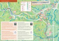
Argyll – the Lochgilphead area<br />
The Cr<strong>in</strong>an Canal<br />
9<br />
To Loch Awe<br />
and Oban<br />
Kilmart<strong>in</strong> Glen: Temple Wood<br />
Stone Circles (Historic <strong>Scotland</strong>)<br />
Kilmart<strong>in</strong> Glen: Ballygowan<br />
Cup And R<strong>in</strong>g Marks.<br />
(Historic <strong>Scotland</strong>)<br />
Kilmart<strong>in</strong><br />
Kimart<strong>in</strong> House Museum<br />
Category: Canal towpath<br />
Distance: 6.5miles/10.5 kilometres<br />
Time: 1 hour<br />
Gradient: Flat<br />
Surface: Wh<strong>in</strong> dust<br />
Kilmart<strong>in</strong> Glen:<br />
Ri Cru<strong>in</strong> Cairn<br />
(Historic <strong>Scotland</strong>)<br />
Kilmart<strong>in</strong> Glen: Dunchraigaig Cairn (Historic <strong>Scotland</strong>)<br />
Kilmart<strong>in</strong> Glen: Baluachraig Cup<br />
and R<strong>in</strong>g Marks (Historic <strong>Scotland</strong>)<br />
<strong>Go</strong>od circular route to Kilmart<strong>in</strong> us<strong>in</strong>g this<br />
m<strong>in</strong>or road. Use OS Explorer Map 358<br />
Cr<strong>in</strong>an<br />
Faery Isles Mounta<strong>in</strong><br />
Bike Trails<br />
Loch Cr<strong>in</strong>an<br />
Start/<br />
F<strong>in</strong>ish<br />
Bellanoch<br />
Barnluasgan<br />
Visitor Centre<br />
B8025<br />
B841<br />
Kilmart<strong>in</strong> Glen:<br />
Dunadd Fort (Historic <strong>Scotland</strong>)<br />
Mo<strong>in</strong>e Mhor <strong>National</strong><br />
Nature Reserve<br />
(Scottish Natural Heritage)<br />
Cr<strong>in</strong>an Canal<br />
Cairnbaan<br />
Kilmichael<br />
Glassary<br />
A816<br />
Bridgend<br />
Glasham and Ardcastle<br />
Mounta<strong>in</strong> Bike Trails<br />
Kilmart<strong>in</strong> Glen:<br />
Kilmichael Glassary Cup<br />
and R<strong>in</strong>g Marks (Historic <strong>Scotland</strong>)<br />
Kilmart<strong>in</strong> Glen: Cairnbaan Cup<br />
and R<strong>in</strong>g Marks (Historic <strong>Scotland</strong>)<br />
Fire Tower Mounta<strong>in</strong><br />
Bike Trails<br />
Kilmart<strong>in</strong> Glen: Achnabreck Cup<br />
and R<strong>in</strong>g Marks. (Historic <strong>Scotland</strong>)<br />
Lochgair<br />
23<br />
The shipp<strong>in</strong>g shortcut of the west coast, the<br />
Cr<strong>in</strong>an Canal, is a delight for cyclists of all ages.<br />
Dark peaty waters fill this wide canal which l<strong>in</strong>ks<br />
the Atlantic with Loch Fyne. Jo<strong>in</strong> the towpath by<br />
Lochgilphead and turn right to cycle through lush<br />
countryside.<br />
At Cairnbaan, there’s the first <strong>in</strong> a series of locks.<br />
To the north of the village lies Kilmart<strong>in</strong> Glen<br />
which conta<strong>in</strong>s hundreds of Cup and R<strong>in</strong>g marked<br />
stones, chambered cairns and stone circles<br />
dat<strong>in</strong>g from Neolithic/Bronze Age times. Cont<strong>in</strong>ue<br />
on the canal by Mó<strong>in</strong>e Mhór (The Great Bog) to<br />
reach the attractive harbour at Cr<strong>in</strong>an.<br />
For a more adventurous ride, head south on the<br />
canal towpath to Ardrishaig. Before the canal<br />
<strong>in</strong>tersects the ma<strong>in</strong> road cross a bridge to the<br />
right and head up through the residential streets<br />
and lanes untill you come to the start of a track<br />
that leads along the hillside above Loch Gilp. Best<br />
suited to mounta<strong>in</strong> bikes, there are some steep<br />
gradients, but spectacular views.<br />
Ardrishaig<br />
Off-road<br />
alternative. Forest<br />
track. Steep<br />
sections. Expect<br />
variable surfaces<br />
To K<strong>in</strong>tyre and<br />
Campbeltown<br />
Start/<br />
F<strong>in</strong>ish<br />
Cr<strong>in</strong>an Canal<br />
A83<br />
Loch Gilp<br />
Lochgilphead<br />
Miles<br />
0 1<br />
0 1 2<br />
Kilometres<br />
A83<br />
3<br />
2<br />
Loch Fyne<br />
24
The Trossachs and Glen Ogle<br />
Kill<strong>in</strong><br />
Aberfoyle (Cobleland) to Callander<br />
Callander to Strathyre<br />
K<strong>in</strong>gshouse to Kill<strong>in</strong><br />
p28<br />
p30<br />
p32<br />
On-road <strong>National</strong> <strong>Cycle</strong> <strong>Network</strong> section<br />
<strong>Traffic</strong>-free <strong>National</strong> <strong>Cycle</strong> <strong>Network</strong> section<br />
Balquhidder<br />
Balquhidder<br />
Station<br />
K<strong>in</strong>gshouse<br />
Lochearnhead<br />
Other routes<br />
Time: The time given to complete a route is calculated on an<br />
average travell<strong>in</strong>g time of 7 miles or 11 km per hour. This allows<br />
for a leisurely cycl<strong>in</strong>g pace or for plenty of stops. Times and<br />
distances given for l<strong>in</strong>ear routes are for one way only.<br />
Miles<br />
0<br />
0<br />
Kilometres<br />
5 10<br />
5 10 15<br />
Strathyre<br />
Kilmahog<br />
Callander<br />
Easter<br />
Dullater<br />
Aberfoyle<br />
Kirkton<br />
Cobleland<br />
W<strong>in</strong>dygate<br />
23 25<br />
24 26<br />
The Glen Ogle Viaduct near Kill<strong>in</strong> © Jenny Baker
Loch Achray<br />
Aberfoyle (Cobleland) to Callander 10<br />
To Stronachlachar<br />
Loch<br />
Katr<strong>in</strong>e<br />
Miles<br />
0<br />
0<br />
Kilometres<br />
1<br />
1<br />
2<br />
3<br />
2<br />
Ben Ledi<br />
Map 11<br />
Falls of Leny<br />
Kilmahog<br />
Callander<br />
Sir Walter Scott<br />
Steamship<br />
Brig o’Turk<br />
Roman Fort<br />
Start/<br />
F<strong>in</strong>ish<br />
Scottish <strong>Cycle</strong> Centre<br />
Loch Venachar<br />
Loch<br />
Drunkie<br />
Queen Elizabeth<br />
Forest Park<br />
B829<br />
Queen Elizabeth Forest<br />
Park Visitor Centre<br />
Scottish Wool<br />
Centre<br />
Kirkton<br />
Aberfoyle<br />
Cunn<strong>in</strong>ghame Graham Memorial<br />
(<strong>National</strong> Trust for <strong>Scotland</strong>)<br />
Cobleland<br />
W<strong>in</strong>dygate<br />
Start/<br />
F<strong>in</strong>ish<br />
To Balloch and<br />
Glasgow<br />
Category: Railway path, forestry route, loch shore cycle path and<br />
m<strong>in</strong>or road<br />
Distance: 15 miles/24 kilometres<br />
Time: 3 hours<br />
Gradient: Flat to Aberfoyle followed by a long sharp climb and<br />
descent to Loch Venachar. Flat thereafter<br />
Surface: Tarmac, forestry roads. Mounta<strong>in</strong> bike recommended<br />
This mixed route has a very flat start and f<strong>in</strong>ish, but a very hilly<br />
middle! The latter, with its steep off-road climb through Achray<br />
Forest, is test<strong>in</strong>g, even for the fittest. In complete contrast, the<br />
other sections are ideal for all the family; the f<strong>in</strong>ish by Loch<br />
Venachar offers some of the best cycl<strong>in</strong>g <strong>in</strong> <strong>Scotland</strong>.<br />
Start from Cobleland to follow an old railway l<strong>in</strong>e by the <strong>in</strong>fant<br />
River Forth. <strong>Cycle</strong> through Aberfoyle before the climb through the<br />
forest – rewarded with great views from the top. Descend by Loch<br />
Drunkie and look out for Route 7 signs direct<strong>in</strong>g you right at a<br />
junction. The path leads by Loch Venachar, which has many picnic<br />
spots.<br />
Carry straight on at the junction to reach Loch Katr<strong>in</strong>e. There’s a<br />
great cycle and walkway round the loch to Stonachlachar where<br />
you and your bike can catch the Steamship Sir Walter Scott back<br />
to the eastern end of the loch or carry on to Inversnaid on the east<br />
shore of Loch Lomond. (Use OS Explorer maps 365 and 364).<br />
27<br />
28
Callander to Strathyre 11<br />
Map 12<br />
Strathyre<br />
Miles<br />
0<br />
1<br />
2<br />
Start/<br />
F<strong>in</strong>ish<br />
0<br />
Kilometres<br />
1 2<br />
3<br />
Take care - Steep zig-zag track<br />
Laggan<br />
Look<strong>in</strong>g across Loch Lubnaig towards <strong>National</strong> Route 7<br />
© Fergal MacErlean<br />
Loch<br />
Lubnaig<br />
Chalets<br />
Stank<br />
A84(T)<br />
Category: Railway path<br />
Distance: 9.5 miles/15 kilometres<br />
Time: 1 hour 30 m<strong>in</strong>utes<br />
Gradient: Flat start to Falls of Leny. Thereafter undulat<strong>in</strong>g with<br />
some short climbs<br />
Surface: Tarmac, wh<strong>in</strong> dust<br />
This almost entirely off-road route is a big favourite with families<br />
and others look<strong>in</strong>g for a quiet cycle. From Callander a level<br />
cyclepath follows the old Oban railway l<strong>in</strong>e alongside the River<br />
Leny. Just outside the town it passes the rema<strong>in</strong>s of a Roman<br />
fort at Bochastle – one of several <strong>in</strong> the area.<br />
Pass the mesmeris<strong>in</strong>g Falls of Leny and cont<strong>in</strong>ue, through an<br />
oakwood, to reach Loch Lubnaig, which has a strong Highland<br />
character. The cycle route uses a quiet access road for some of<br />
the way. Take a picnic – you’re sure to f<strong>in</strong>d an idyllic spot for<br />
lunch. After four flat miles you’ll encounter some hills and one<br />
very steep zig-zag section but the f<strong>in</strong>al stretch <strong>in</strong>to Strathyre is<br />
a breeze.<br />
Ben Ledi<br />
Falls of Leny<br />
Kilmahog<br />
Callander<br />
Roman Fort<br />
Start/<br />
F<strong>in</strong>ish<br />
29<br />
Scottish <strong>Cycle</strong> Centre<br />
Map 10 30
K<strong>in</strong>gshouse to Kill<strong>in</strong> 12<br />
Moirlanich Longhouse<br />
(<strong>National</strong> Trust<br />
for <strong>Scotland</strong>)<br />
Castle (Ru<strong>in</strong>)<br />
Loch Tay<br />
Kill<strong>in</strong><br />
Start/<br />
F<strong>in</strong>ish<br />
Breadalbane Folklore Centre<br />
To Kenmore and<br />
Pitlochry<br />
Loch Voil by Balquhidder © Fergal MacErlean<br />
Mobile Snack Bar<br />
(Usually)<br />
Miles<br />
0<br />
1<br />
2<br />
Viaduct<br />
Glen Ogle<br />
Category: Railway path, forestry road<br />
Distance: 10 miles/16 kilometres<br />
Time: 2 hours<br />
Gradient: Undulat<strong>in</strong>g to Lochearnhead then stiff climb and long<br />
<strong>in</strong>cl<strong>in</strong>e up Glen Ogle. Ma<strong>in</strong>ly downhill and flat to Kill<strong>in</strong><br />
Surface: Tarmac, wh<strong>in</strong> dust, forestry road<br />
0 1 2<br />
Kilometres<br />
3<br />
Take care - Steep zig-zag track<br />
Lochearnhead<br />
A84(T)<br />
Loch<br />
Earn<br />
Ed<strong>in</strong>ample<br />
Enjoy another entirely off-road section of <strong>National</strong> Route 7 as you<br />
travel north to the beautiful village of Kill<strong>in</strong>. Jo<strong>in</strong> the route off the<br />
m<strong>in</strong>or road to Balquhidder, which is worth a look itself as it’s the<br />
rest<strong>in</strong>g place of Rob Roy. The <strong>in</strong>corrigible outlaw – forced by a<br />
crooked landlord <strong>in</strong>to a life of cattle rustl<strong>in</strong>g – is synonymous with<br />
the surround<strong>in</strong>g rugged landscape.<br />
As you approach Lochearnhead, you’ll experience this<br />
ruggedness first hand where the cyclepath climbs alarm<strong>in</strong>gly<br />
before a long <strong>in</strong>cl<strong>in</strong>e up Glen Ogle. Enjoy the views and catch<br />
your breath at the top before cont<strong>in</strong>u<strong>in</strong>g through forestry for a<br />
well deserved rest <strong>in</strong> Kill<strong>in</strong>.<br />
Rob Roy’s Grave<br />
Puidreag Plantation<br />
(Woodland Trust)<br />
Balquhidder<br />
Loch Voil<br />
Start/<br />
F<strong>in</strong>ish<br />
Balquhidder<br />
Station<br />
K<strong>in</strong>gshouse<br />
31<br />
Map 11<br />
32
Northumberland<br />
<strong>National</strong> <strong>Cycle</strong> <strong>Network</strong> <strong>in</strong> <strong>Scotland</strong><br />
From gentle rides along old railway l<strong>in</strong>es, canal<br />
towpaths and quiet country routes over moorland,<br />
mounta<strong>in</strong> and forest terra<strong>in</strong>, cycl<strong>in</strong>g <strong>in</strong> <strong>Scotland</strong><br />
has someth<strong>in</strong>g for everyone.<br />
This map shows the <strong>National</strong> <strong>Cycle</strong> <strong>Network</strong><br />
routes <strong>in</strong> <strong>Scotland</strong>. You may want to cycle part of<br />
them as a day trip or enjoy a longer cycle.<br />
Stromness<br />
1<br />
Kirkwall<br />
SHETLAND ISLANDS<br />
1<br />
Unst<br />
See page 38 for a list of maps and guides<br />
available from <strong>Sustrans</strong>.<br />
1<br />
Thurso<br />
John o'Groats<br />
1<br />
Lerwick<br />
Tongue<br />
Sumburgh<br />
1<br />
Lairg<br />
Ta<strong>in</strong><br />
Cullen<br />
Cromarty<br />
Nairn<br />
Forres<br />
Elg<strong>in</strong><br />
Buckie<br />
Banff<br />
Inverness<br />
Turriff<br />
Maud<br />
7<br />
79<br />
78<br />
Carrbridge<br />
1<br />
Lochboisdale<br />
Broadford<br />
Glenelg<br />
Loch Ness<br />
Aviemore<br />
Dyce<br />
Castlebay<br />
79<br />
Invergarry<br />
Fort Augustus<br />
K<strong>in</strong>gussie<br />
Newtonmore<br />
Cairngorms <strong>National</strong> Park<br />
195<br />
Aberdeen<br />
Loch Lochy<br />
Stonehaven<br />
78<br />
Fort William<br />
7<br />
Blair Atholl<br />
Pitlochry<br />
Montrose<br />
Aberfeldy<br />
Dunkeld<br />
7<br />
Arbroath<br />
Kill<strong>in</strong><br />
77<br />
Dundee<br />
Taynuilt<br />
Carnoustie<br />
Loch Lomond<br />
Monifieth<br />
Oban<br />
& The Trossachs<br />
775<br />
On-road section<br />
Perth<br />
777<br />
Leuchars<br />
78<br />
<strong>National</strong> Park<br />
St Andrews<br />
775<br />
777<br />
776<br />
<strong>Traffic</strong>-free sections<br />
Callander<br />
1<br />
Tarbet<br />
765<br />
1<br />
76<br />
Aberfoyle<br />
Proposed routes<br />
Glenrothes<br />
Alloa<br />
766<br />
Colonsay<br />
Cr<strong>in</strong>an<br />
40<br />
7<br />
Stirl<strong>in</strong>g<br />
764<br />
Dunferml<strong>in</strong>e<br />
Selected regional routes<br />
Kirkcaldy<br />
75<br />
Larbert /<br />
76<br />
Kirk<strong>in</strong>tilloch<br />
Stenhousemuir<br />
/ Lenzie<br />
Towns with railway stations<br />
Ed<strong>in</strong>burgh<br />
Dumbarton<br />
754<br />
Clydebank<br />
Greenock<br />
75<br />
Bathgate 75<br />
Musselburgh<br />
76<br />
Tarbert<br />
Glasgow<br />
Towns without railways stations<br />
Kilmacolm<br />
78<br />
Paisley<br />
East End<br />
73<br />
Lochw<strong>in</strong>noch<br />
Airdrie<br />
Liv<strong>in</strong>gston Balerno Dalkeith<br />
Claonaig<br />
1 <strong>National</strong> <strong>Cycle</strong> <strong>Network</strong> route number<br />
Kennacraig<br />
Barrhead<br />
Hamilton<br />
Penicuik<br />
Lochranza<br />
7<br />
Berwick-upon-Tweed<br />
Port<br />
Ellen<br />
74<br />
Kilw<strong>in</strong>n<strong>in</strong>g<br />
Carstairs Junction<br />
10 Regional route number<br />
Ardrossan<br />
73<br />
Irv<strong>in</strong>e<br />
82<br />
78<br />
Kilmarnock<br />
Galashiels<br />
73<br />
1<br />
Bamburgh<br />
Brodick<br />
Troon<br />
Melrose<br />
Wooler<br />
68<br />
Ab<strong>in</strong>gton<br />
Mal<strong>in</strong> Head<br />
Ayr<br />
Harwick<br />
Campbeltown<br />
Northumberland<br />
1<br />
Rathl<strong>in</strong> Island<br />
Maybole<br />
Carndonagh<br />
Portrush<br />
Ballycastle<br />
74<br />
Magilligan<br />
Greencastle<br />
Amble<br />
Po<strong>in</strong>t<br />
Buncrana<br />
7<br />
Bushmills<br />
Creeslough<br />
Colera<strong>in</strong>e<br />
93<br />
Ash<strong>in</strong>gton<br />
Cushendun<br />
Castlerock<br />
68<br />
Limavady Ballymoney<br />
Burtonport<br />
Cushendall<br />
Bell<strong>in</strong>gham<br />
Derry/<br />
Lockerbie<br />
96<br />
Blyth<br />
Londonderry<br />
The Glens<br />
92 93<br />
of Antrim<br />
Dumfries<br />
10 Craml<strong>in</strong>gton<br />
Letterkenny<br />
7<br />
Gretna<br />
Claudy<br />
Glenarm<br />
10<br />
Raphoe<br />
Cairnryan<br />
7<br />
72<br />
Tynemouth<br />
Annan<br />
Newcastle<br />
97<br />
Corbridge<br />
South Shields<br />
Portglenone<br />
Newton Stewart<br />
Sperr<strong>in</strong>s<br />
72<br />
Strabane<br />
Stranraer<br />
Castle Douglas<br />
Hexham<br />
Ballymena<br />
Gatehouse<br />
Haltwhistle<br />
Larne<br />
of Fleet<br />
Gateshead<br />
14<br />
Sunderland<br />
73<br />
Silloth<br />
10 Carlisle Brampton<br />
68<br />
Newtownstewart<br />
<strong>Go</strong>rt<strong>in</strong><br />
Toome<br />
Consett<br />
93<br />
Wash<strong>in</strong>gton<br />
72<br />
Alston 7<br />
Seaham<br />
95<br />
95<br />
Antrim<br />
Donegal<br />
Carrickfergus<br />
7<br />
Durham<br />
14<br />
Pettigoe<br />
94<br />
10<br />
Ballyshannon<br />
Omagh<br />
Cookstown<br />
Lough<br />
94<br />
Whiteabbey<br />
Bangor<br />
Maryport<br />
W<strong>in</strong>gate<br />
14<br />
Neagh<br />
Bundoran<br />
Newtownards<br />
Cockermouth<br />
68<br />
1<br />
Hartlepool<br />
Belfast<br />
33 91<br />
92<br />
Work<strong>in</strong>gton<br />
72<br />
20 Stockton<br />
Redcar<br />
34<br />
Belleek<br />
F<strong>in</strong>tona<br />
Penrith<br />
Lisburn<br />
Whitehaven<br />
-on-<br />
Dungannon<br />
Comber<br />
Lower<br />
Lagan Valley<br />
71 Keswick<br />
Tees<br />
94<br />
Appleby<br />
1
Support <strong>Sustrans</strong> today<br />
<strong>Sustrans</strong> is the UK’s lead<strong>in</strong>g<br />
susta<strong>in</strong>able transport charity.<br />
Our vision is a world <strong>in</strong> which people choose to travel <strong>in</strong> ways<br />
that benefit their health and the environment. We work on<br />
practical, <strong>in</strong>novative solutions to the transport challenges fac<strong>in</strong>g<br />
us all. <strong>Sustrans</strong> is the charity beh<strong>in</strong>d the award w<strong>in</strong>n<strong>in</strong>g <strong>National</strong><br />
<strong>Cycle</strong> <strong>Network</strong>, Safe Routes to Schools, Bike It, TravelSmart,<br />
Active Travel, Connect2 and Liveable Neighbourhoods, all<br />
projects that are chang<strong>in</strong>g our world one mile at a time.<br />
Support <strong>Sustrans</strong>.<br />
Jo<strong>in</strong> the movement.<br />
For more <strong>in</strong>formation on the <strong>National</strong> <strong>Cycle</strong> <strong>Network</strong>, to buy<br />
maps and guides or to f<strong>in</strong>d out more about <strong>Sustrans</strong>,<br />
visit www.sustrans.org.uk or call 0845 113 00 65<br />
If you th<strong>in</strong>k what we do sounds sensible, we urgently need<br />
people like you to help us do more. By giv<strong>in</strong>g from £5 a month<br />
you’ll start to make a difference. Without this f<strong>in</strong>ancial support,<br />
<strong>Sustrans</strong> and projects such as the <strong>National</strong> <strong>Cycle</strong> <strong>Network</strong> would<br />
probably not exist.<br />
To become a <strong>Sustrans</strong> Supporter today please complete the<br />
form on the opposite page and send it to:<br />
<strong>Sustrans</strong><br />
<strong>Free</strong>post BS7739<br />
Bristol<br />
BS1 5FA<br />
or phone 0845 838 0651<br />
Please complete this form and send it to:<br />
<strong>Sustrans</strong>, <strong>Free</strong>post BS7739, Bristol BS1 5FA.<br />
Alternatively, you can make a donation onl<strong>in</strong>e by visit<strong>in</strong>g<br />
www.sustrans.org.uk or over the phone on 0845 838 0651.<br />
First name<br />
Address<br />
Surname<br />
Postcode<br />
Telephone<br />
E-mail address<br />
Data protection: We promise that any <strong>in</strong>formation you give will<br />
be used by <strong>Sustrans</strong> only and not passed to any other<br />
organisation. If you would prefer us not to contact you about<br />
special appeals please tick here<br />
How to donate: Choose your preferred donation method and<br />
complete either section A or B and section C<br />
A<br />
YES<br />
I’ll jo<strong>in</strong><br />
<strong>Sustrans</strong><br />
with a<br />
Direct Debit<br />
B<br />
YES<br />
I’ll jo<strong>in</strong><br />
<strong>Sustrans</strong><br />
with a<br />
Donation<br />
Your monthly gift will provide us with vital<br />
regular <strong>in</strong>come to help us develop the <strong>National</strong><br />
<strong>Cycle</strong> <strong>Network</strong> and enable us to keep our<br />
adm<strong>in</strong>istration costs to a m<strong>in</strong>imum.<br />
(Please tick) £5 £10 £15 £ other<br />
Please complete the Direct Debit <strong>in</strong>structions<br />
overleaf.<br />
(Please tick) £20 £30 £50 £ other<br />
Please enclose a cheque/PO/Charity Voucher<br />
payable to <strong>Sustrans</strong> and send this form to:<br />
<strong>Sustrans</strong>, <strong>Free</strong>post BS7739, Bristol BS1 5FA<br />
Please send me a pack on leav<strong>in</strong>g a legacy<br />
to <strong>Sustrans</strong><br />
If you’d like to help <strong>Sustrans</strong> <strong>in</strong> a hands-on way, why not<br />
become a volunteer ranger?<br />
As a <strong>Sustrans</strong> Volunteer Ranger you will help to look after and<br />
promote a section of the <strong>National</strong> <strong>Cycle</strong> <strong>Network</strong> near your<br />
home, and so encourage more people to cycle and walk.<br />
To f<strong>in</strong>d how to become a Volunteer Ranger visit<br />
www.sustrans.org.uk/rangers<br />
Registered Charity No. 326550 (England and Wales)<br />
SCO39263 (<strong>Scotland</strong>)<br />
35 36<br />
!<br />
C<br />
Gift Aid<br />
Make your<br />
support go<br />
further for free<br />
Make your support go further for free. Use Gift<br />
Aid and you can make your donation worth<br />
more. For every pound you give to us we get<br />
an extra 25 pence from the Inland Revenue.<br />
Simply tick the boxes below, it’s that simple.<br />
I am a UK taxpayer and want <strong>Sustrans</strong> to<br />
treat all donations that I make from the date of<br />
this declaration until I notify you otherwise as<br />
Gift Aid donations.<br />
I am a UK taxpayer and would like <strong>Sustrans</strong><br />
to Gift Aid all donations with<strong>in</strong> the charity’s<br />
current f<strong>in</strong>ancial period and the previous six<br />
years until I notify you otherwise.<br />
You will need to pay an amount of <strong>in</strong>come tax and/or capital ga<strong>in</strong>s<br />
tax equal to the tax we claim on your donations (currently 25p for<br />
every £1 you give). Thank you.
Also available from <strong>Sustrans</strong><br />
Instruction to your Bank or Build<strong>in</strong>g Society to pay<br />
by Direct Debit<br />
Please fill <strong>in</strong> the whole form and send it to:<br />
<strong>Sustrans</strong>, <strong>Free</strong>post BS7739, Bristol, BS1 5FA<br />
Name and full postal address of your Bank or Build<strong>in</strong>g Society<br />
To: The Manager<br />
Address<br />
Name(s) of Account Holder(s)<br />
Bank/Build<strong>in</strong>g Society account number<br />
Branch sort code<br />
Orig<strong>in</strong>ator’s <strong>in</strong>dentification number<br />
6 7 2 6 7 7<br />
Reference number<br />
Bank/Build<strong>in</strong>g Society<br />
Instruction to your Bank or Build<strong>in</strong>g Society<br />
Please pay <strong>Sustrans</strong> Direct Debits from the account detailed <strong>in</strong><br />
this <strong>in</strong>struction subject to the safeguards assured by the Direct<br />
Debit Guarantee. I understand that this <strong>in</strong>struction may rema<strong>in</strong><br />
with <strong>Sustrans</strong> and, if so, details will be passed electronically to<br />
my Bank or Build<strong>in</strong>g Society.<br />
Signature(s)<br />
Date<br />
Postcode<br />
Banks and Build<strong>in</strong>g Societies may not accept Direct Debit <strong>in</strong>structions<br />
for some types of account.<br />
To order maps and guides for stunn<strong>in</strong>g cycl<strong>in</strong>g and walk<strong>in</strong>g<br />
routes throughout <strong>Scotland</strong> and the rest of the UK please call<br />
0845 113 00 65 or visit<br />
www.sustranshop.co.uk<br />
Lochs & Glens Pack<br />
Cover<strong>in</strong>g <strong>National</strong> Route 7<br />
between Inverness<br />
and Carlisle<br />
Code NNP01, £18.00<br />
Coast & Castles Pack<br />
Cover<strong>in</strong>g <strong>National</strong> Route 1<br />
between Newcastle<br />
and Aberdeen<br />
Code NNP04, £16.00<br />
<strong>National</strong> <strong>Cycle</strong> <strong>Network</strong><br />
Maps for <strong>Scotland</strong>:<br />
Lochs & Glens South<br />
Carlisle to Glasgow via the Ayrshire coast<br />
Code NN7B, £6.99<br />
Lochs & Glens North<br />
Northern section of the Lochs and Glens cycle route between<br />
Glasgow and Inverness<br />
Code NN7C, £6.99<br />
Salmon Run<br />
Dundee to Perth and Pitlochry plus five circular rides <strong>in</strong> the<br />
Tay Valley<br />
Code NN77, £3.99<br />
Oban to Campbeltown<br />
Code NN78, £3.99<br />
Aberdeen to John O’Groats<br />
Code NN1E, £2.99<br />
Ed<strong>in</strong>burgh to Aberdeen<br />
Code NN1D, £2.99<br />
Forth & Clyde<br />
Code NN75, £6.99<br />
Round the Forth (2008 edition)<br />
Code NN76, £6.99<br />
Coast & Castles South (2008 edition)<br />
Code NN1C, £6.99<br />
Other booklets <strong>in</strong> this series:<br />
Ed<strong>in</strong>burgh, Fife, Central and Borders<br />
Glasgow and Ayrshire<br />
Firth of Tay to Moray<br />
!<br />
37<br />
38
Area covered by this booklet<br />
Nairn<br />
Inverness<br />
7<br />
Loch Ness<br />
78<br />
Carrbridge<br />
Aviemore<br />
79<br />
Invergarry<br />
Fort Augustus<br />
K<strong>in</strong>gussie<br />
Newtonmore<br />
Loch Lochy<br />
Cairngorms <strong>National</strong> Park<br />
78<br />
Fort William<br />
7<br />
Blair Atholl<br />
Pitlochry<br />
7<br />
Aberfeldy<br />
Kill<strong>in</strong><br />
Loch Lomond<br />
& the Trossachs<br />
<strong>National</strong> Park<br />
Tarbert<br />
Aberfoyle<br />
Callander<br />
74<br />
Cr<strong>in</strong>an<br />
Lochgilphead<br />
75<br />
40<br />
7<br />
Falkirk<br />
To f<strong>in</strong>d maps, route <strong>in</strong>formation and suggested routes<br />
from cyclists throughout <strong>Scotland</strong> visit:<br />
www.routes2ride.org.uk/scotland<br />
<strong>Sustrans</strong> and the <strong>National</strong> <strong>Cycle</strong> <strong>Network</strong><br />
<strong>Sustrans</strong> is the UK’s lead<strong>in</strong>g susta<strong>in</strong>able transport charity,<br />
work<strong>in</strong>g on practical projects so people choose to travel <strong>in</strong><br />
ways that benefit their health and the environment. The charity<br />
is beh<strong>in</strong>d many groundbreak<strong>in</strong>g projects <strong>in</strong>clud<strong>in</strong>g the <strong>National</strong><br />
<strong>Cycle</strong> <strong>Network</strong>, over twelve thousand miles of traffic-free, quiet<br />
lanes and on-road walk<strong>in</strong>g and cycl<strong>in</strong>g routes around the UK.<br />
We are the charity mak<strong>in</strong>g a difference today so everyone can<br />
live a better tomorrow.<br />
Support <strong>Sustrans</strong>. Jo<strong>in</strong> the movement.<br />
For more <strong>in</strong>formation on the <strong>National</strong> <strong>Cycle</strong> <strong>Network</strong>, to buy<br />
maps and guides or to become a <strong>Sustrans</strong> Supporter<br />
visit or call:<br />
Front cover: istock<br />
www.sustrans.org.uk<br />
0845 113 00 65<br />
Registered Charity No. 326550 (England<br />
and Wales) SC039263 (<strong>Scotland</strong>)<br />
This booklet has been produced<br />
with the support of the Scottish <strong>Go</strong>verment<br />
First edition 2009