Open Space and Recreation Plan - Town of North Andover
Open Space and Recreation Plan - Town of North Andover
Open Space and Recreation Plan - Town of North Andover

You also want an ePaper? Increase the reach of your titles
YUMPU automatically turns print PDFs into web optimized ePapers that Google loves.
TOWN OF NORTH ANDOVER<br />
2 0 1 0 OPEN SPACE & RECREATION<br />
PLAN UPDATE<br />
prepared by:<br />
NORTH ANDOVER OPEN SPACE COMMITTEE<br />
A sub-committee <strong>of</strong> the Conservation Commission<br />
&<br />
NORTH ANDOVER CONSERVATION DEPARTMENT<br />
Community Development <strong>and</strong> Services<br />
400 Osgood Street, <strong>North</strong> <strong>Andover</strong>, MA 01845<br />
April 2006 – Updated April 2010
T O W N O F N O R T H A N D O V E R<br />
O P E N S P A C E A N D R E C R E A T I O N P L A N 2 0 0 6<br />
2 0 1 0 U P D A T E<br />
The <strong>Open</strong> <strong>Space</strong> Committee was created in 1996 as a result <strong>of</strong> the 1995 <strong>Open</strong> <strong>Space</strong> <strong>and</strong><br />
<strong>Recreation</strong> <strong>Plan</strong>. Members <strong>of</strong> the <strong>Open</strong> <strong>Space</strong> Committee <strong>and</strong> Conservation Department<br />
include:<br />
Scott Masse<br />
Al Manzi, Jr.<br />
Deb Feltovic<br />
Joe Lynch<br />
Jack Mabon<br />
Sean McDonough<br />
Lou Napoli<br />
Jennifer Hughes, Conservation Administrator<br />
Heidi Gaffney, Conservation Associate<br />
Donna Wedge, Conservation Departmental Assistant<br />
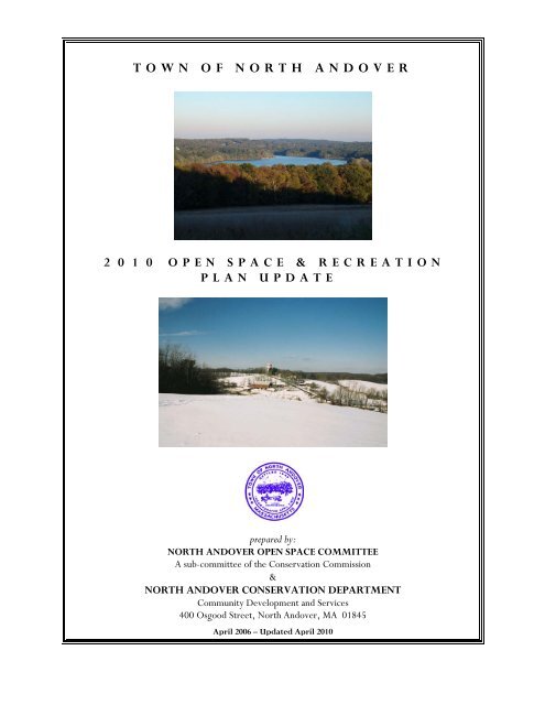
Cover Photograph (top): View <strong>of</strong> Lake Cochichewick from Half Mile Hill Summit.<br />
Picture taken by Pamela A. Merrill<br />
Cover Photograph (bottom): View <strong>of</strong> Barker’s Farm from the Carter Hill Vista.<br />
Picture taken by David J. Solomon<br />
2
T O W N O F N O R T H A N D O V E R<br />
O P E N S P A C E A N D R E C R E A T I O N P L A N 2 0 0 6<br />
2 0 1 0 U P D A T E<br />
T A B L E O F C O N T E N T S<br />
Section 1: PLAN SUMMARY. . . . 4<br />
Section 2: INTRODUCTION. . . . 6<br />
2.1 Statement <strong>of</strong> Purpose<br />
2.2 <strong>Plan</strong>ning Process <strong>and</strong> Public Participation<br />
Section 3: COMMUNITY SETTING . . . . 8<br />
3.1 Regional Context<br />
3.2 Community History<br />
3.3 Population Characteristics<br />
3.4 Growth <strong>and</strong> Development Patterns<br />
Page<br />
Section 4: NATURAL RESOURCE INVENTORY AND ANALYSIS. . 22<br />
4.1 Geology<br />
Surficial Geology, Bedrock Geology, Soils<br />
4.2 L<strong>and</strong>scape Character<br />
Hilltops, Farml<strong>and</strong><br />
4.3 Water Resources<br />
Surface Waters, Wetl<strong>and</strong>s, Flood Hazard Areas<br />
4.4 Vegetation<br />
Non-Forested Resources, Forested Resources<br />
4.5 Fisheries <strong>and</strong> Wildlife<br />
Fisheries, Wildlife, Rare, <strong>North</strong> American Beavers, Threatened <strong>and</strong> Endangered Species<br />
4.6 Scenic Resources <strong>and</strong> Unique Environments<br />
Historic L<strong>and</strong>scapes, Prehistoric Resources, Historic Resources<br />
4.7 Environmental Problems<br />
Hazardous Waste, Air Quality, Development Impact<br />
Section 5: INVENTORY OF CONSERVATION AND RECREATION LAND. 39<br />
5.1 Protected <strong>Open</strong> <strong>Space</strong><br />
Public Protected <strong>Open</strong> <strong>Space</strong>, Private Protected <strong>Open</strong> <strong>Space</strong>, Conservation Restrictions,<br />
5.2 <strong>Plan</strong>ned Residential Development (PRDs)<br />
5.3 Unprotected L<strong>and</strong> <strong>of</strong> Conservation Interest<br />
5.4 Public <strong>Recreation</strong> Areas<br />
Parks <strong>and</strong> Playgrounds, Stewardship Program, Hiking Trails<br />
5.5 Private <strong>Recreation</strong> Areas<br />
5.6 Chapter 61, 61A, 61B<br />
5.7 Agricultural Preservation Restriction Program (APR)<br />
5.8 Master Table<br />
3
T O W N O F N O R T H A N D O V E R<br />
O P E N S P A C E A N D R E C R E A T I O N P L A N 2 0 0 6<br />
2 0 1 0 U P D A T E<br />
Section 6: COMMUNITY GOALS . . . . 59<br />
6.1 Description <strong>of</strong> Process<br />
6.2 Statement <strong>of</strong> <strong>Open</strong> <strong>Space</strong> <strong>and</strong> <strong>Recreation</strong> Goals<br />
Section 7: NEEDS ASSESSMENT . . . . 62<br />
7.1 Resource Protection Needs<br />
Lake Cochichewick Watershed Protection, Protection <strong>of</strong> <strong>Open</strong> <strong>Space</strong> <strong>and</strong> Rural<br />
Character, Limiting Growth<br />
7.2 Community Needs<br />
7.3 Management Needs<br />
Section 8: GOALS AND OBJECTIVES. . . . 68<br />
Section 9: SEVEN-YEAR ACTION PLAN . . 75<br />
Section 10: Public Comment. . . . 83<br />
Section 11: REFERENCES. . . . 84<br />
Page<br />
LIST OF APPENDICIES<br />
Appendix A: BIRDS OF MAZURENKO FARM CONSERVATION AREA. 89<br />
Appendix B: SOIL ASSOCIATION. . . . 91<br />
Appendix C: BEDROCK GEOLOGY. . . . 92<br />
Appendix D: MAPS. . . . . 93<br />
Zoning Map<br />
Current L<strong>and</strong> Use Map<br />
Action <strong>Plan</strong> Map<br />
<strong>Open</strong> <strong>Space</strong> Map<br />
Estimated Habitat For Endangered Species<br />
Soils Map<br />
Historical Maps (1884)<br />
Appendix E: <strong>Open</strong> <strong>Space</strong> <strong>Plan</strong> Survey . . . 101<br />
Appendix F: ADA Accessibility Report . . . 116<br />
Appendix G: <strong>Town</strong> Owned <strong>Open</strong> <strong>Space</strong> Matrix . . 133<br />
4
T O W N O F N O R T H A N D O V E R<br />
O P E N S P A C E A N D R E C R E A T I O N P L A N 2 0 0 6<br />
1.0 PLAN SUMMARY<br />
2 0 1 0 U P D A T E<br />
The 2006 <strong>North</strong> <strong>Andover</strong> <strong>Open</strong> <strong>Space</strong> <strong>and</strong> <strong>Recreation</strong> <strong>Plan</strong> <strong>and</strong> its 2010 update are essential updates <strong>of</strong> the<br />
comprehensive 2000 <strong>Plan</strong>, which assembled comprehensive input from the 1998 Master <strong>Plan</strong> efforts. In<br />
addition, the 2006 <strong>and</strong> 2010 <strong>Plan</strong>a provides updated inventories <strong>of</strong> <strong>North</strong> <strong>Andover</strong>'s Community Setting,<br />
Environmental features, <strong>and</strong> L<strong>and</strong>s <strong>of</strong> Conservation <strong>and</strong> <strong>Recreation</strong> interest. The <strong>Plan</strong> culminates in a series <strong>of</strong><br />
sixteen (16) updated recommendations from the 2000 <strong>Plan</strong>, supporting:<br />
<br />
<br />
<br />
Sustained Watershed Protection;<br />
Preservation <strong>of</strong> the <strong>Town</strong>'s <strong>Open</strong> <strong>and</strong> Rural character;<br />
And increasing <strong>Recreation</strong>al opportunities <strong>and</strong> quality <strong>of</strong> life in <strong>North</strong> <strong>Andover</strong>.<br />
The full set <strong>of</strong> recommendations appearing in Section 9 are set forth in an updated Seven Year Action <strong>Plan</strong> in<br />
Section 9, according to their importance within the Community <strong>and</strong> their impact on resource conservation.<br />
5
T O W N O F N O R T H A N D O V E R<br />
O P E N S P A C E A N D R E C R E A T I O N P L A N 2 0 0 6<br />
2.0 INTRODUCTION<br />
2.1 STATEMENT OF PURPOSE<br />
2 0 1 0 U P D A T E<br />
The purpose <strong>of</strong> this 2006 <strong>North</strong> <strong>Andover</strong> <strong>Open</strong> <strong>Space</strong> <strong>and</strong> <strong>Recreation</strong> <strong>Plan</strong> is to show where we were,<br />
where we are, <strong>and</strong> where we wish to go in regard to open space <strong>and</strong> recreation in the <strong>Town</strong> <strong>of</strong> <strong>North</strong><br />
<strong>Andover</strong>, Massachusetts. A look at the open space map for the <strong>Town</strong> <strong>of</strong> <strong>North</strong> <strong>Andover</strong> indicates the great<br />
work that has been accomplished by a <strong>Town</strong> that truly cares about its open space <strong>and</strong> image. Critical parcels<br />
<strong>of</strong> l<strong>and</strong> have been acquired for preservation throughout the <strong>Town</strong>, <strong>and</strong> in a significant act <strong>of</strong> <strong>Open</strong> <strong>Space</strong><br />
support, <strong>North</strong> <strong>Andover</strong> was one <strong>of</strong> the first communities in Massachusetts to adopt the Community<br />
Preservation Act at the maximum funding level. Much has been accomplished in the short tenure <strong>of</strong> the<br />
Community Preservation Committee in the form <strong>of</strong> <strong>Open</strong> <strong>Space</strong> acquisitions <strong>and</strong> Watershed protection. It<br />
is no overstatement to assert that Community Preservation Act funding has been the single most significant<br />
contributor to the achievement <strong>of</strong> the 2000 <strong>Open</strong> <strong>Space</strong> <strong>and</strong> <strong>Recreation</strong> <strong>Plan</strong> goals. The <strong>Town</strong> has made<br />
significant progress in <strong>Town</strong>-owned facilities by constructing a new High School in 2004, <strong>and</strong> a new Youth<br />
Center in 2001. Since the inception <strong>of</strong> the original <strong>Open</strong> <strong>Space</strong> <strong>and</strong> <strong>Recreation</strong> <strong>Plan</strong> in 1970, the<br />
community has developed a number <strong>of</strong> similar planning documents, which have also articulated the need to<br />
protect open space <strong>and</strong> provide recreational opportunities for this growing community. These documents<br />
include:<br />
The <strong>North</strong> <strong>Andover</strong> Comprehensive <strong>Plan</strong> 1972<br />
The <strong>Open</strong> <strong>Space</strong> <strong>and</strong> <strong>Recreation</strong> <strong>Plan</strong> 1980, 1987, 1995, 2000<br />
The Phased Development Bylaw 1986<br />
The Balanced Growth <strong>Plan</strong> 1987<br />
The Lake Cochichewick Watershed <strong>Plan</strong> 1987<br />
The ENSR Report on Lake Cochichewick 1987<br />
The Growth Management Bylaw 1996<br />
The Three Interim Master <strong>Plan</strong> Reports 1997, 1998, 1999<br />
The <strong>North</strong> <strong>Andover</strong> Wetl<strong>and</strong>s Protection Bylaw <strong>and</strong> Regulations 1998 REV 9-10-03<br />
The Lake Cochichewick Watershed <strong>Plan</strong> 1999<br />
The ENSR Report on Lake Cochichewick 1999<br />
The <strong>Open</strong> <strong>Space</strong> <strong>and</strong> <strong>Recreation</strong> <strong>Plan</strong> 2000<br />
Essex County <strong>Open</strong> <strong>Space</strong> Reconnaissance Project 2005<br />
The <strong>North</strong> <strong>Andover</strong> Zoning Bylaw 1972 REV 5-2005<br />
6
T O W N O F N O R T H A N D O V E R<br />
O P E N S P A C E A N D R E C R E A T I O N P L A N 2 0 0 6<br />
2 0 1 0 U P D A T E<br />
The <strong>North</strong> <strong>Andover</strong> <strong>Open</strong> <strong>Space</strong> Committee has changed structure <strong>and</strong> appearance significantly since the<br />
2000 <strong>Open</strong> <strong>Space</strong> <strong>and</strong> <strong>Recreation</strong> <strong>Plan</strong>, with adoption <strong>of</strong> the Community Preservation Act in 2001. <strong>North</strong><br />
<strong>Andover</strong> was one <strong>of</strong> the first communities in Massachusetts to institute this Preservation Act. The funds<br />
come from a 3% property surcharge <strong>and</strong> have been matched 100% by the Commonwealth every year. The<br />
<strong>Open</strong> <strong>Space</strong> Committee <strong>and</strong> Conservation Department have continued its progress with developing more<br />
accurate <strong>and</strong> comprehensive open space mapping, <strong>and</strong> has used Community Preservation funds, in<br />
cooperation with the Community Preservation Committee to achieve the goals <strong>of</strong> primary importance in<br />
the areas <strong>of</strong> open space acquisition, watershed protection, historic preservation <strong>and</strong> recreation.<br />
The acquisition <strong>of</strong> significant open space parcels by the Community Preservation Committee since 2000 has<br />
further heightened the need for continued progress in the improvement <strong>of</strong> information, mapping resources<br />
<strong>and</strong> records <strong>of</strong> the new <strong>and</strong> existing <strong>Town</strong>-owned properties. Needs identified in 2000 as:<br />
<br />
<br />
<br />
<br />
<br />
Accurate <strong>Open</strong> <strong>Space</strong> maps<br />
Additional trail maps<br />
Acquisition <strong>of</strong> targeted <strong>Open</strong> <strong>Space</strong> sites<br />
Creation <strong>of</strong> <strong>Open</strong> <strong>Space</strong> interconnections<br />
Community paths <strong>and</strong> village ways<br />
have become a larger task with the advent <strong>of</strong> additional <strong>Open</strong> <strong>Space</strong> purchases. Consequently, the need for<br />
well designed Management <strong>Plan</strong>s <strong>and</strong> execution <strong>of</strong> those plans by the <strong>Town</strong> Departments <strong>and</strong> volunteer<br />
organizations is the logical next step to the l<strong>and</strong> acquisition process. As steward <strong>of</strong> the <strong>Town</strong>-owned <strong>Open</strong><br />
<strong>Space</strong>s, the Conservation Department <strong>and</strong> Commission have taken the lead in developing a revised concept<br />
<strong>of</strong> <strong>Open</strong> <strong>Space</strong> Management, <strong>and</strong> related organizational <strong>and</strong> resource needs. The Community Preservation<br />
Committee is once again a key partnership in cooperative achievement <strong>of</strong> the <strong>Town</strong>’s <strong>Open</strong> <strong>Space</strong><br />
Management goals.<br />
2.2 PLANNING PROCESS AND PUBLIC PARTICIPATION<br />
As open space <strong>and</strong> preservation issues fall under the jurisdiction <strong>of</strong> the Conservation Department, the<br />
Conservation Commission has reviewed the 2000 <strong>Open</strong> <strong>Space</strong> <strong>and</strong> <strong>Recreation</strong> <strong>Plan</strong> <strong>and</strong> completed minor<br />
updates, keeping in place the primary emphasis <strong>of</strong> the 2000 plan. The updated draft plan was reviewed with<br />
all l<strong>and</strong> use boards <strong>and</strong> other related organizations in town, as an opportunity to provide comments, input<br />
<strong>and</strong> contributions to the revised plan.<br />
As overseer <strong>of</strong> the <strong>Town</strong>-owned open spaces, the Conservation Commission has adopted the task <strong>of</strong><br />
updating the 2000 <strong>Open</strong> <strong>Space</strong> & <strong>Recreation</strong> <strong>Plan</strong>. As there were no significant efforts to re-define town<br />
goals <strong>and</strong> preferences, such as the 1998 Master <strong>Plan</strong>, the Community Development Director <strong>and</strong> the<br />
Conservation Department agreed on the approach <strong>of</strong> updating the comprehensive 2000 <strong>Open</strong> <strong>Space</strong> &<br />
<strong>Recreation</strong> plan in July 2005, focusing on updating the focus <strong>of</strong> the goals, in light <strong>of</strong> the past five years<br />
progress. In October 2005, the Conservation Department met with the Community Preservation<br />
Committee to present the concept <strong>of</strong> updating <strong>and</strong> creating <strong>Open</strong> <strong>Space</strong> Management <strong>Plan</strong>s for <strong>Town</strong>owned<br />
l<strong>and</strong> managed by the Conservation Commission. A request for funds will be forthcoming to support<br />
<strong>Open</strong> <strong>Space</strong> Management in alignment with the management concept <strong>and</strong> this plan.<br />
7
T O W N O F N O R T H A N D O V E R<br />
O P E N S P A C E A N D R E C R E A T I O N P L A N 2 0 0 6<br />
3.0 COMMUNITY SETTING<br />
2 0 1 0 U P D A T E<br />
This section discusses how <strong>North</strong> <strong>Andover</strong> evolved. The history <strong>of</strong> the <strong>Town</strong>'s settlement, growth <strong>and</strong><br />
development will be presented. While each community is unique, growth <strong>and</strong> development occurs as a result<br />
<strong>of</strong> interactions with other communities. The regional factors that have had an effect on the community’s<br />
development are also presented. These factors may determine the future challenges that <strong>North</strong> <strong>Andover</strong> will<br />
face.<br />
3.1 REGIONAL CONTEXT<br />
The <strong>Town</strong> <strong>of</strong> <strong>North</strong> <strong>Andover</strong> lies along the banks <strong>of</strong> the Merrimack River in the Merrimack Valley in the<br />
northeast corner <strong>of</strong> Massachusetts. The historical map found in Appendix D shows the Merrimack River as the<br />
community's most prominent natural feature. The river has undoubtedly driven the growth <strong>and</strong> development<br />
<strong>of</strong> most <strong>of</strong> the communities in the Merrimack Valley. In the late 18th century <strong>and</strong> throughout the 19th century,<br />
mills sprouted up along the river <strong>and</strong> its countless tributaries. The smaller tributaries were less prone to<br />
devastating floods <strong>and</strong> were very valuable mill sites. Two <strong>of</strong> those tributaries, the Shawsheen River <strong>and</strong><br />
Cochichewick Brook were located within the original <strong>Andover</strong> settlement. These waterways saw intense mill<br />
development, particularly in the 19th century, which transformed the community from an agricultural village<br />
to a more diverse one <strong>of</strong> mills <strong>and</strong> farml<strong>and</strong>.<br />
<strong>North</strong> <strong>Andover</strong> is a highl<strong>and</strong> on the outer edge <strong>of</strong> the Merrimack Valley. The prominent hills drain into<br />
numerous wetl<strong>and</strong>s. These wetl<strong>and</strong>s are the headwaters <strong>of</strong> three separate rivers: the Ipswich River, the Parker<br />
River <strong>and</strong> Cochichewick Brook. The Ipswich River flows twenty miles to the sea through Boxford, Middleton,<br />
Topsfield, Hamilton, <strong>and</strong> Ipswich. One emergency well <strong>and</strong> one weekend well are located along the Ipswich<br />
River in Ipswich. The Parker River flows through Boxford, Georgetown, <strong>and</strong> Newbury twenty miles to the<br />
sea. Along the way, this river supplies water to underground aquifers, which sustain four public wells in<br />
Georgetown. Countless private wells are also served by underground aquifers in the Parker <strong>and</strong> Ipswich River<br />
watersheds. The <strong>Town</strong> <strong>of</strong> <strong>North</strong> <strong>Andover</strong> has recognized the importance <strong>of</strong> the Ipswich River relative to the<br />
water supplies by requiring the same minimum lot size in much <strong>of</strong> the Ipswich River watershed as in the Lake<br />
Cochichewick Watershed District.<br />
Cochichewick Brook flows from Lake Cochichewick, which is the sole source <strong>of</strong> public drinking water for the<br />
people <strong>of</strong> <strong>North</strong> <strong>Andover</strong>. Lake Cochichewick watershed is approximately 2,732 acres in size, 378 acres (14%)<br />
<strong>of</strong> which lies within the <strong>Town</strong> <strong>of</strong> Boxford. This part <strong>of</strong> Boxford is zoned residential <strong>and</strong> is sparsely developed.<br />
The <strong>Town</strong> <strong>of</strong> <strong>North</strong> <strong>Andover</strong> must continue to keep a watchful eye on the future development <strong>of</strong> this portion<br />
<strong>of</strong> the watershed since the <strong>Town</strong> has little control over it. Experience has shown that controlling growth has<br />
been very difficult in the portion <strong>of</strong> the watershed that lies within <strong>North</strong> <strong>Andover</strong>; controlling growth in another<br />
community will present even more challenges.<br />
Today, regional transportation routes have a major impact on <strong>North</strong> <strong>Andover</strong>'s character. Secondary highways<br />
such as Routes 114, 125 <strong>and</strong> 133 have been important in providing local <strong>and</strong> regional transportation routes.<br />
Route 114 brought goods to <strong>and</strong> from the bustling port <strong>of</strong> Salem. Route 125 was the direct route to the<br />
prosperous mill town <strong>of</strong> Haverhill, while Route 133 was the major route to the mill centers <strong>of</strong> <strong>Andover</strong> <strong>and</strong><br />
Lowell. When they were first laid out, these early roads were the only dependable routes to the regional<br />
8
T O W N O F N O R T H A N D O V E R<br />
O P E N S P A C E A N D R E C R E A T I O N P L A N 2 0 0 6<br />
2 0 1 0 U P D A T E<br />
centers <strong>of</strong> commerce. Such roadways made it possible to transport raw materials to, <strong>and</strong> finished goods from<br />
the local mills.<br />
These roads are now secondary highways that funnel traffic to the two major interstate highways, Routes 93<br />
<strong>and</strong> 495. These highways have had perhaps the greatest impact on the community's growth <strong>and</strong> development in<br />
the latter half <strong>of</strong> this century. Route 93 makes <strong>North</strong> <strong>Andover</strong> accessible for those who work in Metropolitan<br />
Boston, while Route 495 provides quick access to the job markets, which have filled the void left by the failure<br />
<strong>of</strong> the mills throughout the Merrimack Valley.<br />
3.2 COMMUNITY HISTORY<br />
The original settlement <strong>of</strong> <strong>Andover</strong> was located in the area bounded by <strong>Andover</strong>, Osgood <strong>and</strong> Court Streets<br />
<strong>and</strong> Academy Road. It was based on the jointly held field system <strong>of</strong> the part <strong>of</strong> Engl<strong>and</strong> most <strong>of</strong> the founders<br />
came from. The small cluster <strong>of</strong> house lots was surrounded by l<strong>and</strong> used for planting, woods <strong>and</strong> swamps.<br />
By the end <strong>of</strong> the 17 th century, the common field system had devolved into individual holdings. Settlement<br />
had spread into the southern part <strong>of</strong> town that would eventually become the “South Parish” <strong>and</strong> even later,<br />
in 1855, become “<strong>Andover</strong>”, taking the name <strong>of</strong> the original settlement.<br />
In the early 1690s, <strong>Andover</strong> was caught up in the witchcraft hysteria <strong>of</strong> Essex County when dozens <strong>of</strong><br />
residents were imprisoned <strong>and</strong> three hanged. <strong>Andover</strong> men were involved in the several French <strong>and</strong> Indian<br />
Wars, taking part in raids up into Canada. <strong>Andover</strong> was active in the Revolutionary War, sending<br />
minutemen to Concord <strong>and</strong> publishing the full text <strong>of</strong> the Declaration <strong>of</strong> Independence in the <strong>Town</strong><br />
Meeting report.<br />
In the early 19 th century, the <strong>North</strong> Parish was still primarily agricultural, although a thriving, but short-<br />
built in 1802 on the Cochichewick near the Merrimack <strong>and</strong> still exists today. Other mills were built along<br />
lived shoe industry grew up around the crossroads village in what is now the old center. A carding mill was<br />
the brook, which at one time supported 4 major mills connected with textile manufacture. The outlet <strong>of</strong><br />
Cochichewick Brook to the Lake Cochichewick was dammed to regulate the flow <strong>of</strong> waterpower to the<br />
mills, which in turn, would increase the size <strong>of</strong> the lake several times. The original millponds still exists,<br />
hidden behind mill <strong>and</strong> business buildings, <strong>and</strong> residential condominiums. This <strong>of</strong>fers a possible scenic<br />
pathway connecting the Merrimack River with Lake Cochichewick.<br />
The founding <strong>of</strong> the City <strong>of</strong> Lawrence was the catalyst, which led to the division <strong>of</strong> the <strong>Town</strong> into three (3)<br />
segments before the Civil War. In the <strong>North</strong> Parish, now <strong>North</strong> <strong>Andover</strong>, the mills along Cochichewick<br />
Brook grew, <strong>and</strong> a new commercial center developed closer to the Merrimack River <strong>and</strong> to Lawrence.<br />
“Machine Shop Village” is a National Register District in the downtown area that contains examples <strong>of</strong> the<br />
former textile industry buildings, as well as factory-built workers housing, stores, a church <strong>and</strong> an owner’s<br />
residence.<br />
The old center village escaped pressure for development <strong>and</strong> largely retains its 19 th century appearance<br />
today. Several <strong>of</strong> the structures around the Common are owned or protected by the <strong>North</strong> <strong>Andover</strong><br />
Historical Society. The Common itself, created in the 19 th century by the <strong>North</strong> <strong>Andover</strong> Improvement<br />
Society was turned over to the <strong>Town</strong> in the 1950s after the last house had been removed. It serves as a<br />
location for <strong>Town</strong> celebrations <strong>and</strong> for a variety <strong>of</strong> passive recreation uses. It is also the focus <strong>of</strong> the <strong>Town</strong>’s<br />
9
T O W N O F N O R T H A N D O V E R<br />
O P E N S P A C E A N D R E C R E A T I O N P L A N 2 0 0 6<br />
2 0 1 0 U P D A T E<br />
only local historic district. <strong>North</strong> <strong>Andover</strong> residents appreciate the historic character <strong>of</strong> their community,<br />
which still retains many examples <strong>of</strong> buildings <strong>and</strong> l<strong>and</strong>scapes from former days.<br />
Population continued to rise during the 20 th Century, although the shift <strong>of</strong> textile manufacturing to the<br />
South after WWII meant the loss <strong>of</strong> factory jobs. Some <strong>of</strong> these jobs were replaced with new industry such<br />
as the large Western Electric (now Lucent Technologies) plant. Until the 1960s, however the eastern <strong>and</strong><br />
southern sections <strong>of</strong> town were still largely undeveloped open space.<br />
3.3 POPULATION CHARACTERISTICS<br />
The population <strong>of</strong> <strong>North</strong> <strong>Andover</strong> has grown steadily throughout the 20 th century. Table 3.31 demonstrates<br />
this growth over the past 100 years.<br />
T able 3.3.1<br />
As immigrants came to work in the woolen mills, they tended to settle within walking distance <strong>of</strong> those<br />
mills. This led to a concentration <strong>of</strong> factory housing, modest homes <strong>and</strong> a few owners’ mansions in a<br />
relatively dense settlement in the northwest part <strong>of</strong> <strong>Town</strong> along Cochichewick Brook. Many <strong>of</strong> the <strong>Town</strong>’s<br />
recreational areas are located in these older neighborhoods, <strong>and</strong> are heavily used.<br />
Up until the last quarter <strong>of</strong> the century, the rest <strong>of</strong> the <strong>Town</strong> was mainly undeveloped, with a number <strong>of</strong><br />
farms <strong>and</strong> few large country estates bordering Lake Cochichewick, built by wealthy mill owners. From<br />
1950 to 1970, the population almost doubled. During this period, Routes 93 <strong>and</strong> 495 were completed,<br />
10
T O W N O F N O R T H A N D O V E R<br />
O P E N S P A C E A N D R E C R E A T I O N P L A N 2 0 0 6<br />
2 0 1 0 U P D A T E<br />
putting <strong>North</strong> <strong>Andover</strong> within driving distance <strong>of</strong> employment in the Metropolitan Boston region;<br />
therefore, making the <strong>Town</strong> attractive as a residence for commuters. Rapid growth has continued<br />
throughout the 21 st century.<br />
<strong>North</strong> <strong>Andover</strong>’s population has grown to 29,549 as estimated by the <strong>Town</strong> Clerk’s <strong>of</strong>fice in November<br />
2005. This population increase has led to a corresponding decrease in open space, even though the<br />
perception <strong>of</strong> <strong>North</strong> <strong>Andover</strong> as a town with a great deal <strong>of</strong> open space is one <strong>of</strong> the reasons given for<br />
moving here. Past surveys indicate that many residents thought that these open spaces were somehow<br />
protected <strong>and</strong> would remain open.<br />
In conjunction with the overall population growth has come a growth in the senior <strong>and</strong> teenage populations<br />
with their separate recreational needs. The Senior Center that flanks to <strong>Town</strong> Hall was built in 1984 <strong>and</strong><br />
exp<strong>and</strong>ed in 1997. Construction <strong>of</strong> a new Youth Center in the Old <strong>Town</strong> Center was completed in the<br />
summer <strong>of</strong> 2000, <strong>and</strong> a new High School complex was recently completed in 2004 - 05.<br />
Changes in employment trends in Massachusetts can be seen in Table 3.32.<br />
Table 3.32 Employment Trends<br />
Area <strong>of</strong> Employment<br />
Percent in the<br />
Workforce in 1989<br />
Percent in the Percent in the<br />
Workforce in 1998<br />
Workforce in 2000<br />
Manufacturing 54.0 42.0 17.2<br />
Services 15.5 29.0 10.3<br />
Trade 11.0 13.0 9.9<br />
Government 4.2 4.7 11.5<br />
Transportation, Communications,<br />
Public Utilities<br />
7.0 4.2 2.9<br />
Construction 2.7 3.0 3.9<br />
Finance, Insurance, Real Estate 3.6 2.6 10.0<br />
Agriculture, Fisheries, Forestry 0.08 1.3 0.7<br />
Pr<strong>of</strong>essional, Scientific,<br />
Administrative, Management - - 66.3<br />
(Source: Commonwealth <strong>of</strong> Massachusetts, Division <strong>of</strong> Employment <strong>and</strong> Training (ES-202 Series))<br />
*Pr<strong>of</strong>essional, Scientific, Administrative, Management was not previously included.<br />
As with many towns in the state <strong>of</strong> Massachusetts, <strong>North</strong> <strong>Andover</strong> has seen a shift away from manufacturing<br />
jobs <strong>and</strong> toward high tech, service employment. Much <strong>of</strong> the recent population growth has changed <strong>North</strong><br />
<strong>Andover</strong> from a blue collar to a white-collar community. This may increase interest in open space<br />
protection <strong>and</strong> conservation issues. There has been an increased dem<strong>and</strong> for recreational facilities,<br />
particularly playing fields for rapidly growing sports programs, such as soccer <strong>and</strong> baseball. In previous<br />
<strong>Open</strong> <strong>Space</strong> <strong>Plan</strong>s, it was clear that the <strong>Town</strong> was not meeting the community’s recreational needs.<br />
However, within the last five (5) years several recreational fields have been constructed to fulfill this<br />
necessity, including the Carter Farm Soccer Fields (3), Foster Farm Soccer Fields (2), <strong>and</strong> an entire new<br />
track <strong>and</strong> field, as well as soccer, football, baseball <strong>and</strong> s<strong>of</strong>tball fields at the new high school.<br />
11
T O W N O F N O R T H A N D O V E R<br />
O P E N S P A C E A N D R E C R E A T I O N P L A N 2 0 0 6<br />
2 0 1 0 U P D A T E<br />
When the <strong>Plan</strong>ning Board adopted <strong>North</strong> <strong>Andover</strong>’s first master plan (1957), manufacturing jobs comprised<br />
more than 95% <strong>of</strong> the town’s total employment. A “company town” making the transition from textiles to<br />
technology, <strong>North</strong> <strong>Andover</strong> had recently attracted a new Western Electric Company manufacturing plant<br />
on Osgood Street near Haverhill. 7 Although <strong>North</strong> <strong>Andover</strong> aspired to be one <strong>of</strong> the region’s top industrial<br />
centers, manufacturing employment paralleled regional trends <strong>and</strong> gave way to growth in other industries.<br />
During the 1990s, manufacturing employment declined by nearly 50% in <strong>North</strong> <strong>Andover</strong>. Manufacturing<br />
still exceeds other industries for total employment, but service jobs have become an increasingly prominent<br />
part <strong>of</strong> the town’s economy. In 1990, <strong>North</strong> <strong>Andover</strong> had 3.55 manufacturing jobs for every service job; by<br />
2001, the ratio had dropped to 1.43. 8 Similar rates <strong>of</strong> decline have occurred throughout <strong>North</strong> <strong>Andover</strong>’s<br />
region, yet some communities with a much smaller manufacturing base absorbed modest growth in<br />
manufacturing employment toward the end <strong>of</strong> the decade.<br />
<strong>North</strong> <strong>Andover</strong>’s overall population growth included the senior <strong>and</strong> teenage populations with their separate<br />
recreational needs. The Senior Center that flanks <strong>Town</strong> Hall was built in 1984 <strong>and</strong> exp<strong>and</strong>ed in 1997. The<br />
townspeople also constructed a new Youth Center, with primarily private funding, in the Old <strong>Town</strong> Center<br />
in the summer <strong>of</strong> 2000, along with a new High School complex in 2005.<br />
Household Income<br />
<strong>North</strong> <strong>Andover</strong>’s median household income <strong>of</strong> $72,728 ranks 60 th in the Commonwealth <strong>and</strong> is about 1.35<br />
times higher than the median for the Lawrence metropolitan area. While one-third <strong>of</strong> the town’s<br />
households have annual incomes below the Lawrence area median, 8.7% have annual incomes <strong>of</strong> $ 200,000<br />
or more – a rate that in <strong>North</strong> <strong>Andover</strong>’s region is surpassed only by <strong>Andover</strong>, Boxford <strong>and</strong> Topsfield.<br />
Heads <strong>of</strong> households between 45 – 54 years <strong>of</strong> age represented <strong>North</strong> <strong>Andover</strong>’s highest income age group,<br />
with its lowest income households in the very young – people under 24; <strong>and</strong> elderly households headed by<br />
persons over 75. Household type is also important influencing total household income. Families in <strong>North</strong><br />
<strong>Andover</strong> generally have higher incomes than non-family households <strong>and</strong> this applies to <strong>North</strong> <strong>Andover</strong> as<br />
well, but the difference is somewhat more pronounced. <strong>North</strong> <strong>Andover</strong>’s median family income <strong>of</strong><br />
$92,450 is 1.41 times higher than the median household income for the state, a ratio that slightly exceeds<br />
that <strong>of</strong> nearby communities. In addition, non-family households (one-person households <strong>and</strong> households <strong>of</strong><br />
unrelated individuals) usually have somewhat lower incomes in relation to the household median. Again,<br />
<strong>North</strong> <strong>Andover</strong> experience is fairly typical: its median no-family household income is $30,994.<br />
Approximately 2.9% <strong>of</strong> the town’s population falls below the federal poverty st<strong>and</strong>ard. Among persons<br />
below poverty, 82% are below age 65 <strong>and</strong> 63% are in family households.<br />
3.4 GROWTH AND DEVELOPMENT PATTERNS<br />
<strong>North</strong> <strong>Andover</strong> first adopted local zoning in 1943. The current zoning map is included on the following<br />
page. The <strong>North</strong> <strong>Andover</strong> Zoning Bylaw has been revised <strong>and</strong> updated on numerous occasions, most<br />
recently in May 2004. It includes <strong>Plan</strong>ned Residential Development (PRDs) (a.k.a., Cluster Zoning),<br />
Watershed Protection District, Floodplain District, Phased Development Bylaw <strong>and</strong> Site <strong>Plan</strong> Review.<br />
There are seven (7) residential zones including R6 <strong>and</strong> Village Residential. The R6 zone allows six (6) lots<br />
per acre <strong>and</strong> Village Residential zone allows four (4) homes per acre (with sewer). This Village Residential<br />
12
T O W N O F N O R T H A N D O V E R<br />
O P E N S P A C E A N D R E C R E A T I O N P L A N 2 0 0 6<br />
2 0 1 0 U P D A T E<br />
zone has recently been changed back to one (1) home per acre, but there is a significant development gr<strong>and</strong>fathered<br />
under the four (4) homes per acre allowance. To date, there is no remaining l<strong>and</strong> available for<br />
development in the R6 zone.<br />
<strong>North</strong> <strong>Andover</strong>'s Wetl<strong>and</strong>s Protection Bylaw <strong>and</strong> its Regulations, as well the Board <strong>of</strong> Health’s septic<br />
system regulations are more restrictive than the MA Wetl<strong>and</strong>s Protection Act (M.G.L. c.131 .40) <strong>and</strong> Title<br />
V, State Sanitary Code, (310 CMR 11.00). The Conservation Commission has also specified eight (8) rivers<br />
protected under the MA River’s Protection Act <strong>and</strong> in the local Wetl<strong>and</strong>s Protection Bylaw. These rivers<br />
include the Merrimack River, Cochichewick Brook, the Shawsheen River, Mosquito Brook, Boston Brook,<br />
Fish Brook, Cedar Brook <strong>and</strong> Rocky Brook. These local regulations have been necessary because <strong>of</strong> the large<br />
amount <strong>of</strong> wetl<strong>and</strong>s in town. An increase in conservation applications coupled with the increased need for<br />
sewer connections are indicators <strong>of</strong> poor l<strong>and</strong>. Smaller developers are unable to capitalize developments<br />
with high on <strong>and</strong> <strong>of</strong>f site costs. The trend to larger development firms is related to the greater infrastructure<br />
<strong>and</strong> wetl<strong>and</strong> issues. The Route 114 sewer extension was completed in 2005 to service a 40B development<br />
consisting <strong>of</strong> 270-townhouses <strong>and</strong> condominiums on the <strong>North</strong> <strong>Andover</strong> / Middleton town line. Further<br />
down on Route 114, another area will soon undergo a sewer extension project to service a recently<br />
approved condominium <strong>and</strong> single-family house development paid by the developers. The development<br />
community will need to build homes in order to recoup infrastructure costs. The larger firms will be able to<br />
weather market fluctuations better than smaller builders. The only tools that will temper this growth are<br />
two (2) growth bylaws.<br />
In 2002, a Growth Development Bylaw was introduced in section 8.7 <strong>of</strong> the <strong>North</strong> <strong>Andover</strong> Zoning Bylaw<br />
in an effort to reduce the rapid growth in town. Ironically, town residents voted to remove this provision<br />
during the <strong>Town</strong> Meeting in 2004. The <strong>North</strong> <strong>Andover</strong> Zoning Bylaw also implemented a Phased Growth<br />
Bylaw (section 4.2), which has proven to be more successful to ensure that growth occurs in an orderly <strong>and</strong><br />
planned manner, while avoiding large year-to-year variations in the development rate. Forest View Estates,<br />
a 92-lot subdivision located <strong>of</strong>f Route 114 was phased over a three (3) year period. A remaining problem is<br />
the number <strong>of</strong> gr<strong>and</strong>fathered lots that predate the Phased Growth Bylaw, <strong>and</strong> therefore are considered<br />
exempt. Another issues the town has been facing is over the last ten (10) years is a rapid growth in<br />
population. As a result, the <strong>North</strong> <strong>Andover</strong> has faced numerous challenges to match community services.<br />
This bylaw <strong>and</strong> other regulations attempt to provide the <strong>Plan</strong>ning Board, Conservation Commission, Board<br />
<strong>of</strong> Health <strong>and</strong> Zoning Board <strong>of</strong> Appeals with the tools to control growth. The Master <strong>Plan</strong> Committee has<br />
recommended that the Zoning Bylaw be revised <strong>and</strong> reorganized on a regular basis to adequately guide the<br />
future growth <strong>and</strong> development <strong>of</strong> the community.<br />
The town has taken steps to promote development by amending several zoning provisions over the last few<br />
years. Those changes were approved during previous <strong>Town</strong> Meetings <strong>and</strong> include:<br />
<br />
<br />
The rezoning <strong>of</strong> a parcel <strong>of</strong> l<strong>and</strong> from Residential 4 to General Business Route 114 across from<br />
the Eagle Tribune. The Eaglewood Shops was recently completed in the fall 2005 <strong>and</strong> consists<br />
<strong>of</strong> two (2) restaurants, several clothing shops, a bank, <strong>of</strong>fice supply store, <strong>and</strong> sporting goods<br />
store.<br />
The rezoning <strong>of</strong> a parcel <strong>of</strong> l<strong>and</strong> from Business 4 to General Business, located on the corner <strong>of</strong><br />
Peters Street <strong>and</strong> Route 114. A 24-hour CVS was constructed in 2004.<br />
13
T O W N O F N O R T H A N D O V E R<br />
O P E N S P A C E A N D R E C R E A T I O N P L A N 2 0 0 6<br />
2 0 1 0 U P D A T E<br />
<br />
<br />
The rezoning <strong>of</strong> a parcel <strong>of</strong> l<strong>and</strong> from Residential 1 to Business 2 located on Osgood Street.<br />
The rezoning <strong>of</strong> a parcel <strong>of</strong> l<strong>and</strong> from Industrial 3 to Industrial 1, located on Sharpner’s Pond<br />
Road near the Cyr Recycling Center <strong>and</strong> <strong>Recreation</strong>al Fields.<br />
The <strong>Plan</strong>ning Board has submitted two (2) articles at this year’s 2006 <strong>Town</strong> Meeting relative to changing<br />
the current zoning designation <strong>of</strong> certain parcels to Corridor Development District 1 (CDD1) or Corridor<br />
Development District 2 (CDD2). These new zoning districts would control the design <strong>of</strong> commercial <strong>and</strong><br />
residential development along the primary corridors for vehicular travel on Route 114, Route 133, <strong>and</strong><br />
Route 125 in such a manner that encourages sound site planning, appropriate l<strong>and</strong> use, the preservation <strong>of</strong><br />
aesthetic <strong>and</strong> visual character <strong>and</strong> promote economic development <strong>and</strong> diversity in the community tax base<br />
for the town.<br />
14
T O W N O F N O R T H A N D O V E R<br />
O P E N S P A C E A N D R E C R E A T I O N P L A N 2 0 0 6<br />
2 0 1 0 U P D A T E<br />
INSERT ZONING MAP HERE – PLEASE REFER TO THE ZONING MAP LOCATED IN APPENDIX D<br />
15
T O W N O F N O R T H A N D O V E R<br />
O P E N S P A C E A N D R E C R E A T I O N P L A N 2 0 0 6<br />
2 0 1 0 U P D A T E<br />
<strong>North</strong> <strong>Andover</strong>’s zoning has always heavily favored residential development over commercial or industrial<br />
growth. Eighty-five percent (85%) <strong>of</strong> the <strong>Town</strong> is zoned residential. The Master <strong>Plan</strong> stresses the need for<br />
greater commercial <strong>and</strong> industrial growth to <strong>of</strong>fset costs <strong>of</strong> providing services to the residents. The “out<br />
country” area has seen significant development over the last ten (10) years, necessitating the building <strong>of</strong> a<br />
new elementary school, the rebuilding <strong>and</strong> enlargement <strong>of</strong> two (2) existing elementary school, <strong>and</strong><br />
expansion <strong>of</strong> the Middle School. <strong>Town</strong> growth has also exceeded the capacity <strong>of</strong> the High School facility,<br />
which was redeveloped for up to 1400 students in 2004. This growth pressure also prompted unsuccessful<br />
override proposals for a third fire station, <strong>and</strong> a new Public Safety Center. Using Community Preservation<br />
funding, the <strong>Town</strong> was able to renovate the historic <strong>Town</strong> Hall building downtown to ease the growth <strong>of</strong><br />
much needed <strong>of</strong>fice space. Also under stress from the accelerated growth are the <strong>Town</strong>'s playing fields.<br />
During the 1998 <strong>Town</strong> Meeting, the residents voted to acquire the Foster Farm property. This 92-acre<br />
parcel was divided into two (3) parcels; parcel A is designated as the new site for an elementary school <strong>and</strong><br />
related recreational uses, managed <strong>and</strong> controlled by the School Committee. Parcels B & C, which includes<br />
Bruin Hill are designated as open space to preserve the existing agricultural fields <strong>and</strong> historic features, <strong>and</strong><br />
controlled <strong>and</strong> managed by the Conservation Commission.<br />
As in many other Massachusetts towns, much <strong>of</strong> the new residential building has resulted in large <strong>and</strong><br />
expensive homes. Even some homes originally marketed as empty-nester homes have become very<br />
desirable with prices reflecting that, <strong>and</strong> have become havens for families with children. <strong>North</strong> <strong>Andover</strong>'s<br />
traditional diversity <strong>of</strong> home styles <strong>and</strong> prices has become less diverse in the past decade.<br />
Both the <strong>Open</strong> <strong>Space</strong> <strong>and</strong> Master <strong>Plan</strong> Committees underst<strong>and</strong> the importance <strong>of</strong> preserving open space,<br />
farml<strong>and</strong> <strong>and</strong> historic scenic vistas as a brake on the inevitable expansion <strong>of</strong> residential development, <strong>and</strong><br />
more importantly as a cost-containment move. In attempting to pay for the needed public buildings <strong>and</strong><br />
services, a corridor study <strong>of</strong> Rte. 114 was planned to find appropriate space for small industrial parks <strong>and</strong><br />
commerce without adversely affecting adjacent residential areas or traditional rural <strong>and</strong> farml<strong>and</strong> vistas.<br />
Studies by the American Farml<strong>and</strong> Trust "suggest that residential l<strong>and</strong> uses cost more in services than they<br />
generate in revenues, <strong>and</strong> that a mix <strong>of</strong> other l<strong>and</strong> uses <strong>of</strong>fsets this imbalance." (American Farml<strong>and</strong> Trust,<br />
1992)<br />
<strong>North</strong> <strong>Andover</strong>’s zoning has always heavily favored residential development over commercial or industrial<br />
growth. Eighty-five percent (85%) <strong>of</strong> the <strong>Town</strong> is zoned residential. The Master <strong>Plan</strong> stresses the need for<br />
greater commercial <strong>and</strong> industrial growth to <strong>of</strong>fset costs <strong>of</strong> providing services to the residents. The “out<br />
country” area has seen significant development over the last ten (10) years, necessitating the building <strong>of</strong> a<br />
new elementary school, the rebuilding <strong>and</strong> enlargement <strong>of</strong> two (2) existing elementary school, <strong>and</strong><br />
expansion <strong>of</strong> the Middle School. <strong>Town</strong> growth has also exceeded the capacity <strong>of</strong> the High School facility,<br />
which was redeveloped for up to 1400 students in 2004. This growth pressure also prompted unsuccessful<br />
override proposals for a third fire station, <strong>and</strong> a new Public Safety Center. Using Community Preservation<br />
funding, the <strong>Town</strong> was able to renovate the historic <strong>Town</strong> Hall building downtown to ease the growth <strong>of</strong><br />
much needed <strong>of</strong>fice space. Also under stress from the accelerated growth are the <strong>Town</strong>'s playing fields.<br />
During the 1998 <strong>Town</strong> Meeting, the residents voted to acquire the Foster Farm property. This 92-acre<br />
parcel was divided into two (3) parcels; parcel A is designated as the new site for an elementary school <strong>and</strong><br />
related recreational uses, managed <strong>and</strong> controlled by the School Committee. Parcels B & C, which includes<br />
Bruin Hill are designated as open space to preserve the existing agricultural fields <strong>and</strong> historic features, <strong>and</strong><br />
16
T O W N O F N O R T H A N D O V E R<br />
O P E N S P A C E A N D R E C R E A T I O N P L A N 2 0 0 6<br />
2 0 1 0 U P D A T E<br />
controlled <strong>and</strong> managed by the Conservation Commission.<br />
As in many other Massachusetts towns, much <strong>of</strong> the new residential building has resulted in large <strong>and</strong><br />
expensive homes. Even some homes originally marketed as empty-nester homes have become very<br />
desirable with prices reflecting that, <strong>and</strong> have become havens for families with children. <strong>North</strong> <strong>Andover</strong>'s<br />
traditional diversity <strong>of</strong> home styles <strong>and</strong> prices has become less diverse in the past decade.<br />
Density<br />
<strong>North</strong> <strong>Andover</strong> is a mature, developed community, still comprised <strong>of</strong> a considerable amount <strong>of</strong> vacant,<br />
developable l<strong>and</strong>, mainly for residential development. According to a build-out study prepared by<br />
Merrimack Valley <strong>Plan</strong>ning Commission for the Executive Office <strong>of</strong> Environmental Affairs’ Community<br />
Preservation Initiative (2000), <strong>North</strong> <strong>Andover</strong> has enough developable l<strong>and</strong> for about 2,300 new dwelling<br />
units <strong>and</strong> 8.37 million square feet (ft 2 ) <strong>of</strong> commercial <strong>and</strong> industrial space. 9<br />
However, most <strong>of</strong> the nonresidential<br />
l<strong>and</strong> in MVPC’s study is in parcels held by existing companies <strong>and</strong> is not currently available.<br />
Both the <strong>Open</strong> <strong>Space</strong> <strong>and</strong> Master <strong>Plan</strong> Committees underst<strong>and</strong> the importance <strong>of</strong> preserving open space,<br />
farml<strong>and</strong> <strong>and</strong> historic scenic vistas as a brake on the inevitable expansion <strong>of</strong> residential development, <strong>and</strong><br />
more importantly as a cost-containment move. In attempting to pay for the needed public buildings <strong>and</strong><br />
services, a corridor study <strong>of</strong> Rte. 114 was planned to find appropriate space for small industrial parks <strong>and</strong><br />
commerce without adversely affecting adjacent residential areas or traditional rural <strong>and</strong> farml<strong>and</strong> vistas.<br />
Studies by the American Farml<strong>and</strong> Trust "suggest that residential l<strong>and</strong> uses cost more in services than they<br />
generate in revenues, <strong>and</strong> that a mix <strong>of</strong> other l<strong>and</strong> uses <strong>of</strong>fsets this imbalance." (American Farml<strong>and</strong> Trust,<br />
1992)<br />
17
T O W N O F N O R T H A N D O V E R<br />
O P E N S P A C E A N D R E C R E A T I O N P L A N 2 0 0 6<br />
2 0 1 0 U P D A T E<br />
This residential housing growth can be seen in Table 3.41 for the years 1988 to 2004.<br />
Table 3.41<br />
New One & Two Family Residential Dwellings Statistics<br />
1988 - 2004<br />
180<br />
160<br />
159 160 164<br />
150<br />
139<br />
140<br />
120<br />
100<br />
80<br />
60<br />
80<br />
52<br />
62 62<br />
87<br />
72 79 95 98 73<br />
54<br />
71<br />
40<br />
20<br />
0<br />
1996<br />
1995<br />
1994<br />
1993<br />
1992<br />
1991<br />
1990<br />
1989<br />
1988<br />
2004<br />
2003<br />
2002<br />
2001<br />
2000<br />
1999<br />
1998<br />
1997<br />
While <strong>North</strong> <strong>Andover</strong> is fortunate to host part <strong>of</strong> Harold Parker State Forest, l<strong>and</strong> owned by the Essex<br />
County Greenbelt Association <strong>and</strong> The Trustees <strong>of</strong> Reservations, only 30% <strong>of</strong> l<strong>and</strong> in the Lake<br />
Cochichewick Watershed District is protected. Acquiring <strong>and</strong> protecting l<strong>and</strong> within the Lake<br />
Cochichewick watershed is the <strong>Open</strong> <strong>Space</strong> Committee's highest priority. With the partnership <strong>of</strong> the<br />
Community Preservation Committee, the town has purchased over 100 acres within the watershed district<br />
since 2001: Carter Hill, Half Mile Hill <strong>and</strong> Summit parcels. In February 2006, the town purchased the 12-<br />
acre Cullen property at 605 Osgood Street with Community Preservation funds <strong>and</strong> with assistance from<br />
the Trust for Public L<strong>and</strong> (TPL). This property is flanked by Osgood Hill, Half Mile Hill <strong>and</strong> Summit, <strong>and</strong><br />
Weir Hill. With acquisition <strong>of</strong> these key properties, the focus has shifted towards effective care <strong>and</strong><br />
management <strong>of</strong> all watershed properties both public <strong>and</strong> private for the long-term preservation <strong>of</strong> a high<br />
quality watershed. There are still significant parcels <strong>of</strong> l<strong>and</strong> abutting the lake, which have no protection <strong>and</strong><br />
are vulnerable to development. These include <strong>North</strong> <strong>Andover</strong> Country Club, Rolling Ridge Conference<br />
Center, Brooks School <strong>and</strong> other fairly large private parcels.<br />
Forested l<strong>and</strong> has decreased because <strong>of</strong> many new developments, <strong>and</strong> the new Title V regulations have had<br />
the unintended consequences <strong>of</strong> clear-cutting whole parcels for septic systems for the new developments.<br />
18
T O W N O F N O R T H A N D O V E R<br />
O P E N S P A C E A N D R E C R E A T I O N P L A N 2 0 0 6<br />
2 0 1 0 U P D A T E<br />
The recent displacement <strong>of</strong> farms <strong>and</strong> forests is reflected in the names <strong>of</strong> recent developments, such as<br />
Forest View Estates, Peachtree Farm, Maplewood Reserve / Oakridge Village, Rocky Brook Estates,<br />
Carter Farm Reservation, Woodl<strong>and</strong> Estates, Brookview Estates, <strong>and</strong> Meetinghouse Commons. The <strong>Open</strong><br />
<strong>Space</strong> Committee values the remaining forestl<strong>and</strong>s for the reasons <strong>of</strong> ecological diversity, wildlife habitat<br />
protection <strong>and</strong> scenic <strong>and</strong> historic preservation.<br />
To date, there are a limited number <strong>of</strong> active farms. Many farmers have sold portions <strong>of</strong>, or all <strong>of</strong> their<br />
farml<strong>and</strong> <strong>of</strong>f to developers, or have been acquired by the <strong>Town</strong> <strong>of</strong> <strong>North</strong> <strong>Andover</strong> through the state’s ‘First<br />
Right <strong>of</strong> Refusal’ under M.G.L. Chapter 61A. However, there are successful producing farms in <strong>North</strong><br />
<strong>Andover</strong>, which are supported by the townspeople. The <strong>Open</strong> <strong>Space</strong> Committee is strongly in favor <strong>of</strong><br />
preserving open scenic vistas <strong>and</strong> historic ways <strong>of</strong> life. The Master <strong>Plan</strong> reflects this same desire. We<br />
encourage the use <strong>of</strong> Chapter 61, 61A <strong>and</strong> 61B tax classifications, as well as Agricultural Preservation<br />
Restrictions (APRs) <strong>and</strong> Conservation Restrictions as methods to preserve these farms.<br />
Another concern <strong>of</strong> the <strong>Open</strong> <strong>Space</strong> Committee, also reflected in the Master <strong>Plan</strong>, is the use <strong>and</strong> amount <strong>of</strong><br />
open space in <strong>Plan</strong>ned Residential Developments (PRDs). Incursions into the open space by homeowners<br />
<strong>and</strong> the use <strong>of</strong> severe slopes as open space have violated the spirit <strong>of</strong> the PRD Bylaw. The <strong>Open</strong> <strong>Space</strong><br />
Committee holds the opinion that the percentage <strong>of</strong> open space required be increased <strong>and</strong> that it be more<br />
visibly marked, more usable <strong>and</strong> accessible.<br />
The next chart, a build out study from the 1997 Interim Master <strong>Plan</strong> Report shows in two ways how many<br />
acres <strong>and</strong> / or lots could be built in each <strong>of</strong> the seven residential zones or six regions <strong>of</strong> town.<br />
2,500.00<br />
Buildout Zoning District Comparision<br />
2,000.00<br />
1,500.00<br />
Acres<br />
with Wetl<strong>and</strong>s<br />
minus Wetl<strong>and</strong>s<br />
1,000.00<br />
500.00<br />
-<br />
R1 R2 R3 R4 R5 R6 VR<br />
19
T O W N O F N O R T H A N D O V E R<br />
O P E N S P A C E A N D R E C R E A T I O N P L A N 2 0 0 6<br />
2 0 1 0 U P D A T E<br />
The startling number that jumps out is 3,800 lots with no wetl<strong>and</strong>s present were available for development.<br />
Another way to interpret this is that wetl<strong>and</strong>s reduce the number <strong>of</strong> buildable lots by 1,020, from 4,820 to<br />
3,800. If all <strong>of</strong> these lots were built on this would result in 30,400 more traffic trips <strong>and</strong> 1,900 more<br />
children. The Conservation Commission’s enhanced ability to manage growth through its Wetl<strong>and</strong><br />
Protection Bylaw is key to preserving these valuable l<strong>and</strong>s.<br />
Table 3.42<br />
Zone<br />
Acres<br />
# <strong>of</strong> Lots<br />
With<br />
Wetl<strong>and</strong>s<br />
# <strong>of</strong> Lots<br />
Without<br />
Wetl<strong>and</strong>s<br />
Wetl<strong>and</strong><br />
Differences<br />
Traffic Trips<br />
per Lot<br />
School<br />
Children per<br />
0.5 lot<br />
R1 2186.75 1057 767 290 6136 383.5<br />
R2 1408.1 1348 1051 297 8408 525.5<br />
R3 428.68 715 681 34 548 340.5<br />
R4 150.06 526 496 30 3968 248<br />
R5 4.75 32 32 -------- 256 16<br />
R6 9.9 86 21 65 168 10.5<br />
VR 269.67 1056 752 304 6016 376<br />
TOTALS 4457.91 4820 3800 1020 25500 1900<br />
Within the last five (5) years, developers have taken advantage <strong>of</strong> the State’s Chapter 40B: Affordable<br />
Housing statue, a Comprehensive Permit Law that allows the developer to bypass local zoning laws, as long<br />
as 25% <strong>of</strong> the development is considered “affordable”, <strong>and</strong> if less than one-tenth <strong>of</strong> the homes in the<br />
community are affordable. The term "affordable” is the rent or sale price for low to moderate-income<br />
families who make less than 80% <strong>of</strong> the median income for the town. A city or town is required to have at a<br />
minimum <strong>of</strong> 10% affordable housing rate in the community. The average value <strong>of</strong> a single-family home in<br />
<strong>North</strong> <strong>Andover</strong> is $437,771 <strong>and</strong> the median family income is $79,154, according to On Board LLC, a real<br />
estate information company (Eric J. Hudson). <strong>North</strong> <strong>Andover</strong> has five (5) 40B developments; Kittredge<br />
Crossing, Meetinghouse Commons, The Residences at Champion Hall, Oakridge Village / Maplewood<br />
Reservation, <strong>and</strong> Waverly Oaks. To date, <strong>North</strong> <strong>Andover</strong> has 5.8% <strong>of</strong> affordable units, falling short <strong>of</strong> the<br />
10% minimum requirement.<br />
Transportation<br />
Despite the size <strong>of</strong> <strong>North</strong> <strong>Andover</strong>’s employment base <strong>of</strong> 861 establishments <strong>and</strong> 18,343 jobs, less than onequarter<br />
<strong>of</strong> its employed residents work locally, with 43% commuting more than 30 minutes to <strong>and</strong> from<br />
work. Good access to high quality surface roads are the main reason <strong>North</strong> <strong>Andover</strong>’s work force commute<br />
to work by driving alone, averaging 28.8 minutes <strong>of</strong> daily travel time. Interstate 495 runs through the<br />
northern corner <strong>of</strong> town, bringing access to the Lawrence Municipal Airport, industrial parks <strong>and</strong><br />
residential areas. Route 114 crosses through the southern half <strong>of</strong> <strong>North</strong> <strong>Andover</strong> <strong>and</strong> <strong>of</strong>fers connections to<br />
Routes 125 <strong>and</strong> 133. Although commuting via public transportation has increased slightly, carpooling has<br />
declined.<br />
20
T O W N O F N O R T H A N D O V E R<br />
O P E N S P A C E A N D R E C R E A T I O N P L A N 2 0 0 6<br />
2 0 1 0 U P D A T E<br />
Of the town’s commuters, 83% drive alone while only 8.5% use some form <strong>of</strong> public transportation on a<br />
daily basis, mainly on commuter rail. It is easy to see why. According to federal census data, only a small<br />
percentage <strong>of</strong> <strong>North</strong> <strong>Andover</strong>’s residents (10.4%) work in Boston or Cambridge, where inbound public<br />
transportation service is available to commuters. Most residents work in suburbs elsewhere in Essex County<br />
or in Middlesex County along I-93 or I-495. Additionally, the MBTA does not have a commuter rail station<br />
in <strong>North</strong> <strong>Andover</strong>. The options for taking the train exists outside <strong>of</strong> town, along the Haverhill/Reading line<br />
in Reading (113 parking spaces), <strong>North</strong> Wilmington (20 spaces), Ballardvale (120 spaces), <strong>Andover</strong> (152<br />
spaces) or Lawrence (163 spaces). <strong>North</strong> <strong>Andover</strong> is also a member <strong>of</strong> the Merrimack Valley Regional<br />
Transit Authority. In addition to regular bus routes that service in <strong>and</strong> around <strong>North</strong> <strong>Andover</strong>, the MVRTA<br />
provides special employment shuttles to the Lucent Technologies site that departs from Lawrence <strong>and</strong><br />
Haverhill.<br />
Water <strong>and</strong> Sewer<br />
The town <strong>of</strong> <strong>North</strong> <strong>Andover</strong> has both water <strong>and</strong> sewer infrastructure throughout the town. Current<br />
estimates show that at least 90% <strong>of</strong> the town is connected to the town’s water system <strong>and</strong> that at least 70%<br />
are connected to the sewer system. Because the town has Lake Cochichewick as a high quality surface<br />
water supply system, a priority has been placed on reducing the number <strong>of</strong> septic systems within the<br />
Watershed Overlay District. This zoning overlay was designed to protect the water supply by limiting the<br />
type <strong>of</strong> activities to those that cause the least amount <strong>of</strong> potential harm to the lake. Since 1996, the total<br />
number <strong>of</strong> septic systems has decreased by 83%, from 396 to the present count <strong>of</strong> 67.<br />
The town has prioritized areas <strong>of</strong> primary interest for connection to the sewer system, as part <strong>of</strong> a longterm<br />
plan, to protect contributing groundwater <strong>and</strong> surface water systems, <strong>and</strong> to promote economic<br />
growth. The priority areas include Route 125, near the former “Lucent” facility, the site <strong>of</strong> the town’s<br />
newly re-zoned 40R district, as well as various “pockets” <strong>of</strong> neighborhoods adjacent to a sewer serviced<br />
area.<br />
21
T O W N O F N O R T H A N D O V E R<br />
O P E N S P A C E A N D R E C R E A T I O N P L A N 2 0 0 6<br />
2 0 1 0 U P D A T E<br />
4.0 NATURAL RESOURCE INVENTORY AND ANALYSIS<br />
4.1 GEOLOGY<br />
Surficial Geology<br />
The <strong>North</strong> <strong>Andover</strong> l<strong>and</strong>scape shows the unmistakable influence <strong>of</strong> continental glaciations. This is most notable<br />
in the presence <strong>of</strong> a number <strong>of</strong> oval-shaped hills, as well as many irregularly shaped swamps <strong>and</strong> bogs resulting<br />
from the disrupted drainage patterns. “These hills are known as drumlins. They are oval shaped hills made <strong>of</strong> a<br />
jumbled combination <strong>of</strong> clay, s<strong>and</strong> <strong>and</strong> boulders called till. The till can be recognized by the mixed distribution<br />
<strong>of</strong> boulders, pebbles, <strong>and</strong> clay. Till is very hard <strong>and</strong> generally gray in color. The soil at the top <strong>of</strong> the till where<br />
it has been weathered is typically a brownish color. Till is sediment deposited directly by the glacier" (Roberts,<br />
1977).<br />
There are a dozen large hills in <strong>North</strong> <strong>Andover</strong>. Roberts identifies two (2) drumlins, but one, Claypit Hill, may<br />
be a kame. ). A kame is the remnant <strong>of</strong> deposits <strong>of</strong> a glacial stream that formed on the valley wall while the<br />
glacier filled the valley. Claypit Hill shows deposits <strong>of</strong> "fine s<strong>and</strong> to gravel to rocks <strong>of</strong> several inches in diameter.<br />
One fresh cut in the hillside showed well defined layering <strong>of</strong> gravel" (Doucette, 1990). Perhaps this is an<br />
ancient kame reshaped by a later glacier into a drumlin.<br />
Much <strong>of</strong> the southern <strong>and</strong> southeastern portion <strong>of</strong> town is made up <strong>of</strong> ground moraine, "bedrock covered by a<br />
thin sheet <strong>of</strong> till" (Roberts, 1977). The combination <strong>of</strong> poorly drained clay-rich till <strong>and</strong> the disruption <strong>of</strong><br />
drainage patterns mentioned above has resulted in the many swamps, marshes <strong>and</strong> bogs found throughout<br />
<strong>Town</strong>, particularly in the southern <strong>and</strong> southeastern portion. These poorly drained soils <strong>and</strong> broad wetl<strong>and</strong>s<br />
present serious limitations for development (particularly with the lack <strong>of</strong> public sewer), but do provide<br />
opportunities for protecting open spaces.<br />
Bedrock Geology<br />
Two major bedrock zones underlie <strong>North</strong> <strong>Andover</strong>; the Merrimack Belt traverse along the extreme northern<br />
portion <strong>of</strong> <strong>Town</strong>, <strong>and</strong> the Nashoba Zone underlies the remainder (Zen et al, 1983). The Merrimack Belt is<br />
mostly composed <strong>of</strong> metamorphosed s<strong>and</strong>stone <strong>and</strong> siltstone. The Nashoba Zone is primarily dominated by<br />
<strong>Andover</strong> granite <strong>and</strong> Sharpners Pond Diorite.<br />
These two major bedrock zones are split by the Clinton-Newbury fault that runs southwest to northeast just<br />
north <strong>of</strong> Lake Cochichewick. This major structural feature runs through southern New Engl<strong>and</strong> <strong>and</strong> was most<br />
active over 250 million years ago (Skehan <strong>and</strong> Murray, 1980). There have been minor earthquakes associated<br />
with this fault including a quake measuring 2.5 on the Richter scale that was felt in Littleton, MA in 1990<br />
(Cook, 1990). A second fault, the Assabet river fault, may run through <strong>Town</strong> in a north / south direction<br />
along the eastern edge <strong>of</strong> the main mass <strong>of</strong> <strong>Andover</strong> granite (Goldsmith, 1991).<br />
22
T O W N O F N O R T H A N D O V E R<br />
O P E N S P A C E A N D R E C R E A T I O N P L A N 2 0 0 6<br />
Soils<br />
2 0 1 0 U P D A T E<br />
The soils found in <strong>North</strong> <strong>Andover</strong> can be classified into four major associations (United States Soil Conservation<br />
Service, 1981). For definitions, please refer to Appendix C.<br />
<br />
<br />
<br />
<br />
Paxton-Woodbridge-Montauk Association<br />
Canton-Charlton-Sutton Association<br />
Charlton-Rock Outcrop-Medisaprists<br />
Hinkley-Windsor-Merrimac<br />
These general soil associations are intended for broad planning purposes only <strong>and</strong> include a wide variety <strong>of</strong> soil<br />
types. Determination <strong>of</strong> actual soil types, their extent <strong>and</strong> suitable uses is made on a site-specific basis through<br />
field identification. Such detailed investigations <strong>of</strong> soil characteristics <strong>and</strong> boundary determinations are made as<br />
part <strong>of</strong> individual l<strong>and</strong> use decisions.<br />
4.2 LANDSCAPE CHARACTER<br />
Hilltops<br />
<strong>North</strong> <strong>Andover</strong>'s l<strong>and</strong>scape is noted for its drumlins. These hills have had an impact on the community's<br />
development patterns. Until recently, the development constraints <strong>and</strong> lack <strong>of</strong> infrastructure left the hillsides<br />
untouched, but the inflated property values <strong>of</strong> recent years has promoted extensive hillside development. Some<br />
<strong>of</strong> these hilltops <strong>of</strong>fer expansive views <strong>of</strong> the Merrimack Valley, Nashoba Valley, Mount Mond<strong>and</strong>nock, <strong>and</strong><br />
even Boston. Erosion <strong>and</strong> sedimentation during hillside construction has proven to be very problematic. The<br />
<strong>Plan</strong>ning Board revised their Subdivision Rules <strong>and</strong> Regulations in 2002. One <strong>of</strong> the revisions requires any<br />
natural slope exceeding 25% over a horizontal distance <strong>of</strong> 10-feet as measured perpendicular to the contour are<br />
protected <strong>and</strong> shall remain in its natural state. Additionally, the <strong>Plan</strong>ning Board also requires a soil erosion <strong>and</strong><br />
sedimentation control plan to accompany a subdivision application.<br />
These large, gently sloped hills were referred to as "Major Heights" in the only <strong>Town</strong>-wide natural resource<br />
inventory as discussed in the <strong>Town</strong>'s first <strong>Open</strong> <strong>Space</strong> <strong>Plan</strong> <strong>of</strong> 1970. "These hills provide an outlook over the<br />
whole town as well as great parts <strong>of</strong> the Merrimack Valley. They also form the skyline <strong>of</strong> the town when seen<br />
from the valleys. Such natural l<strong>and</strong>scape tends to give the town an open appearance much desired by suburban<br />
dwellers <strong>and</strong> highly valued by <strong>North</strong> <strong>Andover</strong> resident." The 1970 <strong>Open</strong> <strong>Space</strong> <strong>Plan</strong> recommended the<br />
"Protection <strong>of</strong> the skyline which gives the town an open appearance..." (<strong>North</strong> <strong>Andover</strong> Conservation<br />
Commission, 1970).<br />
The 1972 Comprehensive <strong>Plan</strong> also recommended the protection <strong>of</strong> eight (8) prominent hills from intense<br />
development to "retain the rural character <strong>of</strong> natural hills" (Brown, 1972). Of these eight (8) hills, <strong>Town</strong> Farm<br />
Hill <strong>and</strong> Claypit Hill have since been covered by large subdivisions. <strong>Plan</strong>ned Residential Developments (PRD)<br />
have been approved for Barker Hill, Boston Hill (3 lots in 1998) <strong>and</strong> a portion <strong>of</strong> Woodchuck Hill (17 lots in<br />
1995), which preserved some open space. Weir Hill is protected by the Trustees <strong>of</strong> Reservations, <strong>and</strong> the<br />
<strong>Town</strong> <strong>of</strong> <strong>North</strong> <strong>Andover</strong> now owns Osgood Hill <strong>and</strong> Carter Hill. The 1987 Balanced Growth also<br />
recommended the protection <strong>of</strong> the <strong>Town</strong>'s hills. <strong>North</strong> <strong>Andover</strong> needs to be more proactive in protecting<br />
these hilltops before l<strong>and</strong>owners produce development proposals, which can only promote a reactive response.<br />
23
T O W N O F N O R T H A N D O V E R<br />
O P E N S P A C E A N D R E C R E A T I O N P L A N 2 0 0 6<br />
Farml<strong>and</strong><br />
2 0 1 0 U P D A T E<br />
Farml<strong>and</strong> has defined the <strong>Town</strong>'s character since the first settlers arrived. As previously discussed, most <strong>of</strong><br />
<strong>North</strong> <strong>Andover</strong>'s farml<strong>and</strong> has been replaced by residential development since the 1950s. As a response to this,<br />
the 1972 Comprehensive <strong>Plan</strong>'s first long- range goal was to "Retain the natural character <strong>of</strong> woodl<strong>and</strong>s, fields,<br />
<strong>and</strong> farms throughout the <strong>Town</strong> so that they can be used for recreation, conservation <strong>and</strong> enjoyment <strong>of</strong> open<br />
space to the extent possible" (Brown, 1972).<br />
Some l<strong>and</strong>owners file their property under certain taxation classifications such as Chapter 61, Forestry; Chapter<br />
61A, Agricultural <strong>and</strong> Horticultural L<strong>and</strong>s; <strong>and</strong> Chapter 61B, <strong>Open</strong> <strong>Space</strong> / Nature Area / <strong>Recreation</strong>.<br />
Presently fifteen (15) l<strong>and</strong>owners protect 1094.81 acres through the Chapter 61A. This is a 13% decrease since<br />
the 2000 <strong>Open</strong> <strong>Space</strong> & <strong>Recreation</strong> <strong>Plan</strong>. Additionally, there are four (4) l<strong>and</strong>owners that have filed under<br />
Chapter 61 <strong>and</strong> protect approximately 59.62 acres <strong>of</strong> forested areas, <strong>and</strong> three (3) l<strong>and</strong>owners are classified<br />
under Chapter 61B, preserving 62.17 acres open space. When the l<strong>and</strong>owner decides to sell the chapter l<strong>and</strong> or<br />
convert to a different use, the <strong>Town</strong> can exercise its first right <strong>of</strong> refusal to purchase the l<strong>and</strong>. The former<br />
Mazurenko Farm was purchased using this option in 1988 for the purpose <strong>of</strong> watershed protection <strong>and</strong> the<br />
preservation <strong>of</strong> farml<strong>and</strong>. Acquiring this parcel kept the crop <strong>and</strong> hay fields active, <strong>and</strong> eliminated the<br />
development <strong>of</strong> a residential subdivision with potentially harmful impacts on the community's water supply.<br />
This acquisition also triggered the Conservation Commission to create a farming program (agricultural use<br />
license) that allows local farmers to rent usable hay or crop fields. Not only does this program keep the old<br />
agricultural fields active, but it also provides the farmer with additional income <strong>and</strong> crop. To date, the<br />
Conservation Commission rents two (2) fields at Mazurenko Farm, Foster Farm, <strong>and</strong> Half Mile Hill. The most<br />
recent first right <strong>of</strong> refusal purchases was the Foster Farm (Chapter 61A) <strong>and</strong> the Cullen property (Chapter 61).<br />
Overall, little has been done proactively to preserve the remaining open fields <strong>and</strong> farml<strong>and</strong> that has helped to<br />
define the community character; although the <strong>Plan</strong>ned Residential Development (PRDs) concept has been used<br />
successfully to preserve hundreds <strong>of</strong> acres <strong>of</strong> open fields, wetl<strong>and</strong>s, <strong>and</strong> forested upl<strong>and</strong> areas.<br />
One reason why many people accept the loss <strong>of</strong> more natural l<strong>and</strong>scapes is the common misconception that<br />
there is a financial gain to the community from the conversion <strong>of</strong> these l<strong>and</strong> uses to residential or commercial<br />
development. A better underst<strong>and</strong>ing <strong>of</strong> the positive financial impact <strong>of</strong> l<strong>and</strong> preservation would hopefully<br />
improve the attitude <strong>of</strong> not only l<strong>and</strong>owners, but also municipal policy-makers toward l<strong>and</strong> preservation.<br />
Various studies, such as the American Farml<strong>and</strong> Trust (AFT) study previously cited, have shown that residential<br />
growth is more <strong>of</strong> a strain on local services than preserving open l<strong>and</strong>, forests <strong>and</strong> farml<strong>and</strong>. Over the last five<br />
(5) years, Massachusetts’ prime farml<strong>and</strong> has seen a 66% lost as a result <strong>of</strong> development.<br />
One common claim made to Massachusetts’ towns is that residential development increases the local tax base,<br />
thereby lowering property taxes. Others are that resource conservation is too expensive at the local level, <strong>and</strong><br />
that farml<strong>and</strong> does not make a significant contribution to the tax base, so it is best converted to its "highest <strong>and</strong><br />
best use," which is generally assumed to be development. The AFT found although residential development<br />
increases the local tax base, it does not pay for itself. These towns paid more on residential services than they<br />
received from residential services. (American Farml<strong>and</strong> Trust, 1992)<br />
24
T O W N O F N O R T H A N D O V E R<br />
O P E N S P A C E A N D R E C R E A T I O N P L A N 2 0 0 6<br />
Table 4.21<br />
2 0 1 0 U P D A T E<br />
Ratio <strong>of</strong> Dollars Generated to Services Required by Different L<strong>and</strong> Uses<br />
Residential Commercial/Industrial Farm & <strong>Open</strong> L<strong>and</strong><br />
$1:1.12 $1:0.41 $1:0.33<br />
(Source: American Farml<strong>and</strong> Trust, 1992)<br />
The American Farml<strong>and</strong> Trust has conducted a number <strong>of</strong> studies to determine the fiscal impacts <strong>of</strong> different<br />
l<strong>and</strong> uses. In all six (6) studies conducted, residential development <strong>of</strong> open space lost money for the community<br />
while commercial / industrial <strong>and</strong> farm / open l<strong>and</strong> uses generated more in revenue than they required in<br />
services. Thus, a dependence on residential growth to fund municipal budgets is a losing battle. More<br />
diversified l<strong>and</strong> uses must be promoted to ensure economic stability. Hopefully, a better underst<strong>and</strong>ing <strong>of</strong> this<br />
issue will generate a more positive economic view <strong>of</strong> farml<strong>and</strong> <strong>and</strong> open space.<br />
4.3 WATER RESOURCES<br />
The term ‘water resources' is a broad one, which encompasses st<strong>and</strong>ing <strong>and</strong> moving water bodies, <strong>and</strong><br />
vegetated wetl<strong>and</strong>s such as swamps <strong>and</strong> marshes, floodplains <strong>and</strong> groundwater. These water resources are<br />
described in this section. There is no comprehensive mapping ever completed <strong>of</strong> all these resources.<br />
However, the MA Executive Office <strong>of</strong> Environmental Affairs (EOEA) designed a s<strong>of</strong>tware program called<br />
Massachusetts Geographic Information System (MassGIS), the Commonwealth's Office <strong>of</strong> Geographic <strong>and</strong><br />
Environmental Information database. Through this free program, the Commonwealth has created a<br />
comprehensive, statewide database <strong>of</strong> spatial information for environmental planning <strong>and</strong> management.<br />
Recent legislation has established MassGIS as the <strong>of</strong>ficial state agency assigned to the collection, storage <strong>and</strong><br />
dissemination <strong>of</strong> geographic data. While this program has a plethora <strong>of</strong> useful information <strong>and</strong> is updated<br />
frequently, it may not always be accurate <strong>and</strong> should be used for informational purposes.<br />
Most municipalities within the state <strong>of</strong> Massachusetts are required to implement a stormwater bylaw as part <strong>of</strong><br />
the EPA’s National Pollutant Discharge Elimination System (NPDES) permit program. In 2008, the <strong>North</strong><br />
<strong>Andover</strong> adopted a town-wide stormwater bylaw applying to “l<strong>and</strong> disturbances <strong>of</strong> 43,560 square feet or more<br />
<strong>of</strong> l<strong>and</strong> associated with construction or reconstruction <strong>of</strong> structures”. Any project requiring approval by the<br />
town <strong>Plan</strong>ning Board or Conservation Commission is exempt from the provisions <strong>of</strong> this bylaw. The town also<br />
intends to create a set <strong>of</strong> regulations to guide implementation <strong>of</strong> the bylaw. The regulations will make<br />
maximum use <strong>of</strong> Low Impact Development 9LID) techniques <strong>and</strong> promote more sustainable <strong>and</strong><br />
environmentally sound building <strong>and</strong> development practices.<br />
Surface Waters<br />
In a regional context, much <strong>of</strong> <strong>North</strong> <strong>Andover</strong> is a highl<strong>and</strong> at the junction <strong>of</strong> three watersheds: the<br />
Merrimack River <strong>and</strong> the headwaters <strong>of</strong> two rivers: the Ipswich River (via Boston Brook <strong>and</strong> Mosquito<br />
Brook) <strong>and</strong> the Parker River. Much <strong>of</strong> the southern <strong>and</strong> southeastern portion <strong>of</strong> town flows into the Ipswich<br />
River. The northern <strong>and</strong> western portion <strong>of</strong> town drains into the Merrimack River. Two (2) Merrimack River<br />
sub-drainage areas <strong>of</strong> note are the Shawsheen River <strong>and</strong> Cochichewick Brook. As we have seen, water resources<br />
25
T O W N O F N O R T H A N D O V E R<br />
O P E N S P A C E A N D R E C R E A T I O N P L A N 2 0 0 6<br />
2 0 1 0 U P D A T E<br />
have driven the town’s origin <strong>and</strong> development, hydropower in particular. Early in the town's history there was<br />
"hardly a stream or brook <strong>of</strong> any size that was not put in requisition by the settlers as waterpower for grinding<br />
or sawing" (Bailey, 1880).<br />
Today, Lake Cochichewick is the sole source <strong>of</strong> public drinking water. An underst<strong>and</strong>ing <strong>of</strong> the vulnerability <strong>of</strong><br />
water resources has been learned the hard way - through the degradation <strong>of</strong> our public water supply. Pollutants<br />
from a number <strong>of</strong> sources including: house construction, septic systems <strong>and</strong> urban stormwater degraded water<br />
quality until 1986 when giardia was discovered in the Lake. A 'boil water order' followed. A filtration plant<br />
was constructed, a three-year building moratorium was instituted throughout the watershed, <strong>and</strong> a<br />
comprehensive watershed study was commissioned. A portion <strong>of</strong> this study's Diagnostic Conclusions provides<br />
a picture <strong>of</strong> the threats to the water supply from increased growth <strong>and</strong> development:<br />
<br />
<br />
<br />
Water quality <strong>of</strong> the inlet streams is degraded compared to water quality in-lake. Given the present<br />
degraded quality <strong>of</strong> inflows, there is potential for in-lake water quality to deteriorate in the future<br />
even without a corresponding degradation <strong>of</strong> inflows.<br />
The watershed to the lake has residential <strong>and</strong> agricultural uses, which contribute to these periodic<br />
water quality problems. Erosion <strong>of</strong> soils in areas <strong>of</strong> new construction <strong>and</strong> agricultural areas, <strong>and</strong> urban<br />
storm water run<strong>of</strong>f appear to be the primary sources <strong>of</strong> elevated suspended solids, nutrients <strong>and</strong><br />
bacteria concentrations.<br />
Over half <strong>of</strong> the watershed to the lake is presently forested, <strong>and</strong> is a prime site for future residential<br />
development. Further development in the watershed will lead to increases in nutrient loading <strong>and</strong><br />
urban stormwater run<strong>of</strong>f. Lake development is experiencing low growth <strong>and</strong> is expected to continue<br />
in that fashion.<br />
(IEP, 1987)<br />
As a result <strong>of</strong> the Lake Cochichewick Watershed <strong>Plan</strong> (in conjunction with the Balanced Growth <strong>Plan</strong>), a<br />
number <strong>of</strong> steps were taken to protect the water supply. These included major revisions to the Zoning Bylaw,<br />
Board <strong>of</strong> Health Rules <strong>and</strong> Regulations, Wetl<strong>and</strong>s Regulations, l<strong>and</strong> acquisition, increased street sweeping, <strong>and</strong><br />
an extension <strong>of</strong> sewer system. The level <strong>of</strong> success in protecting the water supply, particularly in promulgating<br />
comprehensive recommendations has been greater than in many communities.<br />
Watershed protection measures should manage all threats to the water supply. Updates to the Zoning Bylaw aid<br />
this. In February 1999 the Zoning Bylaw implemented four (4) “No Disturbance” requirements to assist in<br />
preserving the purity <strong>of</strong> groundwater, Lake Cochichewick, <strong>and</strong> its tributaries; to maintain the groundwater<br />
table; <strong>and</strong> to maintain the filtration <strong>and</strong> purification functions <strong>of</strong> the l<strong>and</strong> while preserving the natural<br />
environment <strong>and</strong> protecting the public safely health <strong>and</strong> welfare. The Watershed District is divided into the<br />
following zones:<br />
General Zone:<br />
All l<strong>and</strong> located beyond 400-feet horizontally from the annual mean high<br />
water mark <strong>of</strong> Lake Cochichewick <strong>and</strong> all wetl<strong>and</strong> resources, (as defined in<br />
M.G.L. c131, s.40, <strong>and</strong> the <strong>North</strong> <strong>Andover</strong> Wetl<strong>and</strong>s Bylaw) located within<br />
the watershed.<br />
26
T O W N O F N O R T H A N D O V E R<br />
O P E N S P A C E A N D R E C R E A T I O N P L A N 2 0 0 6<br />
2 0 1 0 U P D A T E<br />
Non-Discharge Buffer Zone:<br />
All l<strong>and</strong> areas located between 250-feet <strong>and</strong> 400-feet horizontally from<br />
annual mean high water mark <strong>of</strong> Lake Cochichewick <strong>and</strong> between 150-feet<br />
<strong>and</strong> 400-feet horizontally from the edge <strong>of</strong> all wetl<strong>and</strong> resources (as defined<br />
in M.G.L. c131, s.40, <strong>and</strong> the <strong>North</strong> <strong>Andover</strong> Wetl<strong>and</strong>s Bylaw) located<br />
within the watershed.<br />
Non-Disturbance Buffer Zone:<br />
Conservation Zone:<br />
All areas located within 150-feet <strong>and</strong> 250-feet horizontally from the annual<br />
high water mark <strong>of</strong> Lake Cochichewick, <strong>and</strong> between 75-feet <strong>and</strong> 150-feet<br />
horizontally from the edge <strong>of</strong> all wetl<strong>and</strong> resources (as defined in M.G.L.<br />
c131, s.40, <strong>and</strong> the <strong>North</strong> <strong>Andover</strong> Wetl<strong>and</strong>s Bylaw) located within the<br />
watershed.<br />
All l<strong>and</strong> areas located within 150-feet horizontally from the annual mean high<br />
water mark <strong>of</strong> Lake Cochichewick, <strong>and</strong> within 75-feet horizontally from the<br />
edge <strong>of</strong> all wetl<strong>and</strong> resources (as defined in M.G.L. c131, s.40, <strong>and</strong> the<br />
<strong>North</strong> <strong>Andover</strong> Wetl<strong>and</strong>s Bylaw) located within the watershed.<br />
Approximately 30% <strong>of</strong> l<strong>and</strong> in the watershed is protected open space. These parcels include Osgood Hill, Half-<br />
Mile Hill <strong>and</strong> Summit, Mazurenko <strong>and</strong> Rea's Pond Conservation Areas, Carter Hill, <strong>and</strong> a large portion <strong>of</strong> the<br />
<strong>Town</strong> Farm; all <strong>of</strong> these properties are owned by the <strong>Town</strong> <strong>of</strong> <strong>North</strong> <strong>Andover</strong>. The Trustees <strong>of</strong> Reservations<br />
owns the Weir Hill Reservation <strong>and</strong> has a Conservation Restriction on the Edgewood Farm property. In<br />
addition, a portion <strong>of</strong> Smolak Farm is protected under an Agricultural Preservation Restriction <strong>and</strong> the Essex<br />
County Greenbelt Association owns several properties within the watershed including Cater Fields<br />
Reservation. The remaining l<strong>and</strong> in the watershed is not protected <strong>and</strong> will likely be developed at some point.<br />
Most reservoirs are surrounded by much more protected l<strong>and</strong>. Much more must be done to protect l<strong>and</strong> in the<br />
watershed, whether through conservation restrictions or acquisition.<br />
L<strong>and</strong> in the watershed is sought after for residential development since the open spaces, lake views <strong>and</strong> larger<br />
lots increase the desirability <strong>and</strong> value this l<strong>and</strong>. Even when the real estate market was at its most depressed<br />
state in 1989-91, l<strong>and</strong> in the watershed continued to be developed at a higher rate than non-watershed l<strong>and</strong>.<br />
Therefore, the community must not only be vigilant in its protection <strong>of</strong> these resources, but also be open to<br />
new protection measures such as improved regulations <strong>and</strong> acquisition.<br />
Wetl<strong>and</strong>s<br />
<strong>North</strong> <strong>Andover</strong> was one <strong>of</strong> the first communities in the Commonwealth to organize a Conservation<br />
Commission in 1961 when it adopted Chapter 40, §8C <strong>of</strong> the Massachusetts General Laws. The Commission<br />
quickly went to work on the very general task <strong>of</strong> protecting the <strong>Town</strong>'s natural resources. Since the passage <strong>of</strong><br />
the Wetl<strong>and</strong>s Protection Act (M.G.L. Chapter 131, §40) in 1972, the Commission has rigorously enforced the<br />
provisions <strong>of</strong> this Act. The Commission not only enforces the state Wetl<strong>and</strong>s Protection Act, but also a local<br />
Wetl<strong>and</strong>s Protection Bylaw <strong>and</strong> Regulations. This Bylaw (<strong>and</strong> its subsequent revisions) has been in effect since<br />
1979. Comprehensive Wetl<strong>and</strong>s Protection Regulations were adopted early in 1991. These regulations provide<br />
detail <strong>and</strong> performance st<strong>and</strong>ards to support the local Bylaw. The <strong>Town</strong> <strong>of</strong> <strong>North</strong> <strong>Andover</strong>’s Wetl<strong>and</strong>s<br />
Protection Bylaw <strong>and</strong> Regulations was revised in 1998 <strong>and</strong> most recently in September 2003. The Conservation<br />
27
T O W N O F N O R T H A N D O V E R<br />
O P E N S P A C E A N D R E C R E A T I O N P L A N 2 0 0 6<br />
2 0 1 0 U P D A T E<br />
Commission takes great effort to better protect wetl<strong>and</strong> resource areas <strong>and</strong> wildlife habitat. As such the<br />
Wetl<strong>and</strong>s Protection Regulations implements the following setbacks:<br />
25-foot No Disturbance Zone:<br />
50-foot No Build Zone:<br />
50-foot No Disturbance Zone:<br />
75-foot No Build Zone:<br />
No activity is permitted within 25-feet <strong>of</strong> the edge <strong>of</strong> the wetl<strong>and</strong> resource<br />
areas identified in section 1.3 <strong>of</strong> the <strong>North</strong> <strong>Andover</strong> Wetl<strong>and</strong>s Protection<br />
Regulations.<br />
Construction <strong>of</strong> any kind is prohibited within 50-feet <strong>of</strong> the edge <strong>of</strong> the<br />
wetl<strong>and</strong> resource areas identified in section 1.3 <strong>of</strong> the <strong>North</strong> <strong>Andover</strong><br />
Wetl<strong>and</strong>s Protection Regulations.<br />
No activity shall be permitted within 50-feet <strong>of</strong> the delineated edge <strong>of</strong> a<br />
vernal (ephemeral) pool or vernal (ephemeral) pool habitat (whichever is<br />
greater <strong>and</strong> / or more restrictive).<br />
No structures shall be permitted within 75-feet <strong>of</strong> the delineated edge <strong>of</strong> a<br />
vernal (ephemeral) pool or vernal (ephemeral) pool habitat (whichever is<br />
greater <strong>and</strong> / or more restrictive).<br />
100-foot Septic System Setback: No septic system leaching field shall be permitted within 100-feet <strong>of</strong> the<br />
delineated edge <strong>of</strong> a vernal (ephemeral) pool or vernal (ephemeral) pool<br />
habitat (whichever is greater <strong>and</strong> / or more restrictive). Any permitted work<br />
shall not obstruct the migratory pathways <strong>of</strong> the ephemeral pool breeders.<br />
The Commission meets twice a month to review development projects <strong>and</strong> issue permits for work near<br />
wetl<strong>and</strong>s. In addition, the Conservation Commission manages several parcels <strong>of</strong> open space l<strong>and</strong> for agricultural<br />
<strong>and</strong> recreational uses.<br />
In an effort to better protect wetl<strong>and</strong>s, a town-wide wetl<strong>and</strong>s mapping project was completed in 1998 by IEP<br />
Inc. Vegetated wetl<strong>and</strong>s were delineated using aerial photography. Additional data was gathered on vegetation<br />
types, hydrologic data <strong>and</strong> soils through field checking. This data, though now somewhat outdated, has been a<br />
great help to planning staff <strong>and</strong> l<strong>and</strong>owners alike in obtaining concise information about development<br />
constraints <strong>and</strong> underst<strong>and</strong>ing wetl<strong>and</strong>s <strong>and</strong> surface waters.<br />
Flood Hazard Areas<br />
<strong>North</strong> <strong>Andover</strong> lies in the floodplain <strong>of</strong> the Merrimack <strong>and</strong> Shawsheen Rivers to the north <strong>and</strong> west <strong>and</strong> various<br />
tributaries <strong>of</strong> the Ipswich River in the south <strong>and</strong> east. In an effort to protect the community from lost flood<br />
storage, floodplain zoning was adopted in 1979, which restricts building in the flood plain.<br />
During major storm events such as the 100-year event, flooding generally occurs in the same areas. Such<br />
floodplains are associated with all river perennial streams in <strong>North</strong> <strong>Andover</strong>. Some l<strong>and</strong>s in the Shawsheen <strong>and</strong><br />
Merrimack River floodplains have been taken in lieu <strong>of</strong> taxes. These l<strong>and</strong> holdings are not only valuable for<br />
flood control purposes, but also for open space <strong>and</strong> recreation. Potential for trails <strong>and</strong> wildlife habitat<br />
improvement projects are now being considered for these floodplains. Such tax takings, or other acquisitions,<br />
28
T O W N O F N O R T H A N D O V E R<br />
O P E N S P A C E A N D R E C R E A T I O N P L A N 2 0 0 6<br />
2 0 1 0 U P D A T E<br />
should be encouraged since these floodplains help preserve flood control, water quality, wildlife habitat <strong>and</strong><br />
potential sites for both active <strong>and</strong> passive recreation.<br />
Aquifers<br />
According to MassGIS <strong>and</strong> information from the Water Department, there are no viable groundwater sources<br />
for public water supply (see Appendix D, Aquifer Map). The Water Department is pursuing inter-connections<br />
with <strong>Andover</strong> <strong>and</strong> Haverhill for additional water supply from distribution systems during emergencies, but<br />
they are not groundwater sources.<br />
4.4 VEGETATION<br />
The specific open space <strong>and</strong> recreation values we all cherish are dependent on a particular setting. These various<br />
settings are defined, to a great extent, by the vegetation, which grows there. The plant community not only<br />
provides for the visual setting for human enjoyment, but also provides important food, shelter <strong>and</strong> breeding<br />
areas, <strong>and</strong> species <strong>and</strong> structural diversity to sustain countless wildlife species. It’s difficult to think <strong>of</strong> an open<br />
space recreational pursuit that does not rely on a particular setting defined by its vegetation:<br />
<br />
<br />
<br />
<br />
<br />
Wooded trails <strong>and</strong> hilltop vistas for the hiker, photographer, mountain biker or cross-country skier.<br />
Old fields or farml<strong>and</strong>s that attract pheasant, turkey, grouse <strong>and</strong> deer for the hunter.<br />
Dense, unbroken forest for uncommon wildlife such as raptors, neo-tropical migrant birds <strong>and</strong> larger<br />
mammals such as fisher, coyote <strong>and</strong> moose.<br />
Thick shoreline cover along streams <strong>and</strong> ponds providing cover for fish, mammals <strong>and</strong> waterfowl.<br />
A quiet meadow in which to picnic.<br />
Non-Forested Resources<br />
Most people think <strong>of</strong> forests when protecting open space, but the picture is much more complex than that. As<br />
we can see from the settings described above, two <strong>of</strong> the five - the old fields <strong>and</strong> quiet meadows are defined by<br />
the absence <strong>of</strong> trees. Some species <strong>of</strong> wildlife, <strong>and</strong> various recreational pursuits require non-forested areas.<br />
This diversity must be taken into consideration when protecting <strong>and</strong> managing open spaces. Areas <strong>of</strong> diverse<br />
vegetation, such as old fields <strong>and</strong> wet meadows can be protected through acquisition or created / maintained on<br />
existing conservation l<strong>and</strong>.<br />
The introduction <strong>of</strong> non-native plant species can seriously compromise native diversity. "In 1990, the<br />
Massachusetts Natural Heritage <strong>and</strong> Endangered Species Program developed a list <strong>of</strong> 209 invasive alien plans in<br />
Massachusetts, fifty-one <strong>of</strong> which are aggressive nonnative species that are considered to be the most<br />
problematic" (Anderson, 1993). Many invasive species, including purple loosestrife (Lythrum salicaria), glossy<br />
buckthorn (Rhamnus frangula), Common reed (Phragmites arundinacea.), Japanese knotweed (Polygonum<br />
cuspidatum), <strong>and</strong> Multiflora rose (Rosa multiflora) have begun to dominate vegetated wetl<strong>and</strong>s, as well as the<br />
upl<strong>and</strong> <strong>and</strong> forested areas in <strong>North</strong> <strong>Andover</strong>. The control <strong>of</strong> invasive exotics should be considered when<br />
managing conservation l<strong>and</strong>.<br />
29
T O W N O F N O R T H A N D O V E R<br />
O P E N S P A C E A N D R E C R E A T I O N P L A N 2 0 0 6<br />
Forest Resources<br />
2 0 1 0 U P D A T E<br />
<strong>North</strong> <strong>Andover</strong>'s percent <strong>of</strong> forested l<strong>and</strong> apparently has not changed much in the last 40 years. Table 3.42<br />
indicated that in 1951, 53% <strong>of</strong> <strong>North</strong> <strong>Andover</strong> was forested while 48% was forested in 1985. This statistic is<br />
misleading since many residential subdivisions in a forested l<strong>and</strong>scape will be classified as forest in aerial<br />
photograph interpretation. When one reviews aerial photos <strong>and</strong> road maps, a better underst<strong>and</strong>ing <strong>of</strong> <strong>North</strong><br />
<strong>Andover</strong>'s forests can be gained. There are relatively few areas <strong>of</strong> unbroken forest remaining. These remaining<br />
forests include l<strong>and</strong>s that are unbuildable such as swamps <strong>and</strong> protected open space.<br />
<strong>North</strong> <strong>Andover</strong>'s forests are typical for the southern New Engl<strong>and</strong> region. The younger forests, those taking<br />
root after clearing, are characterized by the presence <strong>of</strong> gray birch (Betula populifolia), poplars (Populus sp.) <strong>and</strong><br />
(particularly in the wet areas) red maple (Acer rubrum). Post-agricultural forest may include black cherry (Prunus<br />
serotina), white ash (Fraxinus alba), locust (Robinia pseudo-acacia), red maple (Acer rubrum) <strong>and</strong> apple (Pyrus spp.).<br />
The more mature upl<strong>and</strong> forests are dominated by red oak (Quercus rubra), hickories (Carya sp.), white pine<br />
(Pinus strobus), <strong>and</strong> a wide variety <strong>of</strong> hardwoods. Red maple dominates the majority <strong>of</strong> forested wetl<strong>and</strong>s. A<br />
large Atlantic White Cedar Swamp encompasses Cedar Pond in the southeastern part <strong>of</strong> <strong>North</strong> <strong>Andover</strong> <strong>and</strong><br />
southwestern portion <strong>of</strong> Boxford State Forest. This is ideal habitat for the Hessel’s Hairstreak butterfly<br />
(Callophrys hesseli), species <strong>of</strong> special concern. These may be the remnants <strong>of</strong> the cedar swamps that were an<br />
important resource for the earliest settlers. "Sawing wood for shingles was a pr<strong>of</strong>itable business, <strong>and</strong> there was<br />
such a dem<strong>and</strong> for them in the town that the inhabitants were forbidden to sell them out <strong>of</strong> town without<br />
special permission" (Bailey, 1880). Only a few cedar swamps exist in Massachusetts, most being logged for<br />
shipbuilding <strong>and</strong> shingles many years ago.<br />
No st<strong>and</strong>s <strong>of</strong> old growth forests exist in <strong>North</strong> <strong>Andover</strong>. Approximately 0.05% <strong>of</strong> Massachusetts has been<br />
identified as old growth. This is a result <strong>of</strong> extensive agricultural l<strong>and</strong> use over the last 200 years. There are<br />
some individual specimens that are quite old, particularly 'boundary oaks' <strong>and</strong> street trees, such as white oak,<br />
various red oaks, sugar maples, beech, white pine <strong>and</strong> others. Such specimens should be sought out <strong>and</strong><br />
preserved to remind us <strong>of</strong> what the primeval forest held when the l<strong>and</strong> was first settled.<br />
The Massachusetts Natural Heritage & Endangered Species Program (NHESP) has identified six (6) state-listed<br />
plant species in <strong>North</strong> <strong>Andover</strong>. Only one plant, the purple needlegrass (Aristida purpurascens) a threaten species<br />
was recently observed in 2000. Other species identified by the NHESP include reed bentgrass (Calamagrostis<br />
pickeringii) an endangered species, cat-tail sedge Carex typhina) a threatened species, broom crowberry (Corema<br />
conradii) <strong>of</strong> special concern, <strong>and</strong>rews’ bottle gentian (Gentiana <strong>and</strong>rewsii) an endangered species, <strong>and</strong> New<br />
Engl<strong>and</strong> blazing star (Liastris scarisoa var. novae-angliae) <strong>of</strong> special concern. This, <strong>and</strong> possibly other, rare /<br />
threatened / endangered species will be sought out <strong>and</strong> protected whenever possible.<br />
Only four (4) l<strong>and</strong>owners protect 59.52 acres <strong>of</strong> forested l<strong>and</strong> through Chapter 61, the Massachusetts Forest<br />
Tax Law tax. Approximately 18 more acres have been protected under Chapter 61 since the 2000 <strong>Open</strong> <strong>Space</strong><br />
& <strong>Recreation</strong> <strong>Plan</strong>. This method <strong>of</strong> temporary l<strong>and</strong> preservation has been successful at least in the short term<br />
since no l<strong>and</strong> classified as forestl<strong>and</strong> has been developed since the 1995 <strong>Open</strong> <strong>Space</strong> <strong>Plan</strong>. While more<br />
l<strong>and</strong>owners are now considering this tax classification, the participation is very low. This limited acreage is a<br />
reflection <strong>of</strong> either a lack <strong>of</strong> public knowledge <strong>of</strong> this program <strong>and</strong> /or the limitations <strong>of</strong> this tax classification as<br />
a method <strong>of</strong> protection. The primary limitation <strong>of</strong> these programs is a requirement that the l<strong>and</strong> remain in that<br />
l<strong>and</strong> use for ten years. From previous discussions with the Assessor's Office, l<strong>and</strong>owners are wary <strong>of</strong> such<br />
30
T O W N O F N O R T H A N D O V E R<br />
O P E N S P A C E A N D R E C R E A T I O N P L A N 2 0 0 6<br />
2 0 1 0 U P D A T E<br />
restrictions. Information regarding this tax classification program should be made more available to<br />
l<strong>and</strong>owners.<br />
Today, the forests <strong>of</strong> <strong>North</strong> <strong>Andover</strong> (<strong>and</strong> New Engl<strong>and</strong>) are faced with a myriad <strong>of</strong> stresses. Air pollution<br />
weakens numerous species, particularly white pines <strong>and</strong> other evergreens. The gypsy moth threatens many<br />
species. The once-dominant American chestnut (Castanea dentata) <strong>and</strong> stately American elm (Ulma americana)<br />
were decimated years ago by introduced pests. Some <strong>of</strong> our dominant forest trees such as maple, ash, <strong>and</strong> oak<br />
are threatened by a variety <strong>of</strong> pests <strong>and</strong> other stresses (Houston, 1981). The wildlife that depends on the forest<br />
is being threatened by the loss <strong>of</strong> native tree species <strong>and</strong> forest fragmentation. The issue <strong>of</strong> fragmentation is a<br />
difficult one for an individual community to deal with due to the limitations <strong>of</strong> working in a single community<br />
where the preservation <strong>of</strong> large tracts <strong>of</strong> forest is simply not practical. When protecting <strong>and</strong> managing<br />
forestl<strong>and</strong>, biodiversity <strong>and</strong> the preservation <strong>of</strong> native species must be considered.<br />
4.5 FISHERIES AND WILDLIFE<br />
Fisheries<br />
The protection <strong>of</strong> an important local fishery was stated as a condition <strong>of</strong> the incorporation <strong>of</strong> the <strong>Town</strong> <strong>of</strong><br />
<strong>Andover</strong> in 1646. All rights to the l<strong>and</strong> were sold to the settlers "provided that the Indian called Roger <strong>and</strong> his<br />
company may have liberty to take alewives in Cochichewick River, for their own eating" (Bailey, 1880). As the<br />
early mills industries grew, this fishery was <strong>of</strong> such importance to cause what may have been the first<br />
environmental regulation. In 1695, the town granted permission for a saw mill on Cochichewick Brook "on<br />
condition that this do not stop the passage <strong>of</strong> the fish called alewives" (Bailey, 1880). Later, as the larger mills<br />
sprung up along the Merrimack <strong>and</strong> Cochichewick, the herring disappeared. Bailey mentions the presence <strong>of</strong><br />
perch, bass <strong>and</strong> speckled trout in the 17th century (Bailey, 1880).<br />
Today, our streams, ponds <strong>and</strong> lakes hold a variety <strong>of</strong> species including rainbow trout (Salmo gairdnerii), brown<br />
trout (Salmo trutta), brook trout (Salvelenis fontanalis), largemouth bass (Micropterus salmoides), northern chain<br />
pickerel (Esox niger), yellow perch (Perca flavescens) <strong>and</strong> various panfish. The Massachusetts Division <strong>of</strong> Fisheries<br />
<strong>and</strong> Wildlife stock the Shawsheen River, Fish Brook <strong>and</strong> Boston Brook just outside the <strong>Town</strong> boundaries with<br />
various species <strong>of</strong> trout. These trout travel throughout the river system <strong>and</strong> are an important recreational<br />
fishery. Lake Cochichewick is not stocked since this would attract recreational use, which has been considered<br />
a threat to water quality. The lake does hold panfish, pickerel, perch <strong>and</strong> largemouth bass.<br />
The Merrimack River has recovered greatly from the affects <strong>of</strong> the mills. Shad (Alosa sapidissima), striped bass<br />
(Morone Saxatilis), the endangered short nose sturgeon (Acipenser brevirostrum) <strong>and</strong> Atlantic salmon (Salmo salar)<br />
have returned to the Merrimack while small mouth bass (Micropterus dolomieu) have been successfully<br />
introduced. The success <strong>of</strong> the Merrimack River fishery is an example <strong>of</strong> the great potential for success in<br />
reclaiming resources that were lost or seriously degraded.<br />
Wildlife<br />
In rapidly suburbanizing communities such as ours, wildlife are displaced or threatened far sooner, <strong>and</strong> to a<br />
greater extent, than is commonly understood. A greater underst<strong>and</strong>ing <strong>of</strong> the interactions between species,<br />
between species <strong>and</strong> their surroundings, <strong>and</strong> between humans <strong>and</strong> wildlife can result in the preservation <strong>of</strong> a<br />
greater diversity <strong>of</strong> wildlife. In an effort to gain this underst<strong>and</strong>ing, various studies have been made at the<br />
31
T O W N O F N O R T H A N D O V E R<br />
O P E N S P A C E A N D R E C R E A T I O N P L A N 2 0 0 6<br />
2 0 1 0 U P D A T E<br />
Mazurenko Farm Conservation Area by local volunteer groups. These studies have shown a far greater diversity<br />
<strong>of</strong> plants <strong>and</strong> animals than was previously known. The diversity <strong>of</strong> wildlife is likely due to the presence <strong>of</strong> a large<br />
wetl<strong>and</strong> <strong>and</strong> a diversity <strong>of</strong> habitats present.<br />
Table 4.51<br />
Mammals <strong>of</strong> the Mazurenko Farm Conservation Area<br />
Bat (Eptesicus fuscus)<br />
American beaver (Castor Canadensis)<br />
Chipmunck (Tamias striatus)<br />
Cottontail Rabbit (Sylvilagus floridanus)<br />
Coyote (Canis latrans)<br />
Great horned owl (Bubo virginianus)<br />
Grey Squirrel (Sciurus carolinensis)<br />
Long-tail weasel (Mustela frenata)<br />
Mice, shrews (Soricidae spp.) <strong>and</strong> voles (Microtus spp.)<br />
Mink (Mustela vision)<br />
Mole (Talpidae spp.)<br />
Raccoon (Procyon lotor)<br />
Red Fox (Vulpes vulpes)<br />
Red-tailed hawk (Buteo jamaicensis)<br />
Red squirrel (Tamiasciurus hudsonicus)<br />
River Otter (Lutra canadensis)<br />
Whitetail deer (Odocoileus virginianus)<br />
Woodchuck (Marmota monax)<br />
_____________________________________________________<br />
(Source: Doucette, 1991)<br />
These findings were the result <strong>of</strong> a winter tracking census. It was surprising to discover uncommon species<br />
such as mink, weasel <strong>and</strong> otter still inhabiting the open spaces <strong>and</strong> waterways <strong>of</strong> <strong>North</strong> <strong>Andover</strong>. Other<br />
uncommon species have been seen recently in <strong>North</strong> <strong>Andover</strong>. These include fisher (Marte pennanti), eastern<br />
coyote (Canis latrans) <strong>and</strong> the bald eagle (Haliaeetus leucocephalus). Beaver (Castor canadensis) <strong>and</strong> the great blue<br />
heron (Ardea herodias) have been long term resident at the Mazurenko Farm Conservation Area <strong>and</strong> on the<br />
Shawsheen River. Wild turkey (Maleagris gallopavo) has been sighted at a number <strong>of</strong> locations. These are likely<br />
turkeys or descendants from 33 individuals introduced to a sanctuary within the Boxford State Forest in 1988.<br />
The habitat requirements <strong>of</strong> these species should be considered when protecting <strong>and</strong> managing open spaces.<br />
The diversity <strong>of</strong> bird species in <strong>North</strong> <strong>Andover</strong> can be seen from the variety found in one 120-acre parcel. This<br />
one area boasts well over 50 species. A number <strong>of</strong> species have been observed at Rea's Pond <strong>and</strong> Mazurenko<br />
Farm Conservation Areas in 1990 <strong>and</strong> 1991. These include raptors such as barred owl (Strix varia), great horned<br />
owl (Bubo virginianus) broad-winged hawk (Buteo platypterus), northern harrier (Circus cyaneus), northern shrike<br />
(Lanius excubitor), red-shouldered hawk (Buteo lineatus) <strong>and</strong> red-tailed hawk (Buteo jamaicensis); songbirds such as<br />
bobolink (Dolichonyx oryzivorus), eastern bluebird (sialia sialis), northern oriole (Icterus galbula) <strong>and</strong> pileated<br />
woodpecker (Drycopus pileatus); <strong>and</strong> game birds such as ruffed grouse (Bonasa umbellus), wild turkey (Meleagris<br />
32
T O W N O F N O R T H A N D O V E R<br />
O P E N S P A C E A N D R E C R E A T I O N P L A N 2 0 0 6<br />
2 0 1 0 U P D A T E<br />
gallopavo) <strong>and</strong> wood duck (Aix sponsa). A bird census was conducted at the Mazurenko Farm Conservation Area<br />
<strong>and</strong> is included in Appendix F. A bird census later conducted by the Merrimack Valley Bird Club identified 53<br />
species in this general area (O'Grady, 1993).<br />
Sub-urbanization can either benefit or harm wildlife. Certain species have adapted to humans <strong>and</strong> now thrive.<br />
These include mammals such as the gray squirrel (Sciurus carolinensis), skunk (Mephitis mephitis), red fox (Vulpes<br />
vulpes), raccoon (Procyon lotor), opossum (Didelthis viginiana), as well as birds such as the starling (Sturnus vulgaris),<br />
house sparrow (Passer domesticus), rock dove (Columba livia) <strong>and</strong> American crow (Corvus brachyrhynchos). These<br />
successful species are characterized by two features: all are very adaptable to the human l<strong>and</strong>scape <strong>and</strong> most are<br />
scavengers.<br />
<strong>Open</strong> spaces can provide a haven for native species in a growing community such as <strong>North</strong> <strong>Andover</strong>, including<br />
the great blue heron, which are protected by the Federal Migratory Bird Treaty Act <strong>of</strong> 1918. It’s illegal to<br />
capture, possess, or cause harm to a great blue heron or its nest or eggs. <strong>North</strong> <strong>Andover</strong> is the home to the<br />
largest great blue heron rookery in Essex County <strong>and</strong> is protected by the Essex County Greenbelt Association.<br />
One unfortunate result <strong>of</strong> the success <strong>of</strong> some species (particularly non-native ones such as the starling <strong>and</strong><br />
house sparrow) is the displacement <strong>of</strong> native species. This displacement sometimes takes unique forms. In the<br />
case <strong>of</strong> the cowbird (Molothrus ater), it lays its own egg in the nest <strong>of</strong> another (likely native) bird. The<br />
unknowing foster parent raises the intruder as its own. This example <strong>of</strong> nest parasitism is related to<br />
fragmentation. The habitat needs <strong>of</strong> native species must be considered when managing open spaces.<br />
<strong>North</strong> American Beavers<br />
“The <strong>North</strong> American beaver (Castor canadensis) is an important ‘keystone’ species because the wetl<strong>and</strong> it creates<br />
by damming small order streams support a myriad <strong>of</strong> species.” (Michael Callahan, 2005). Early settlers<br />
harvested beaver to almost extinction for their waterpro<strong>of</strong> pelts. In 1996, Massachusetts’s voters passed a bill<br />
(M.G.L. c. 131 §80A) prohibiting / restricting the use <strong>of</strong> lethal traps, including, but not limited to steel-jaw leg<br />
hold traps, padded jaw traps, Conibear (body-gripping) traps, snares, <strong>and</strong> deadfalls on furbearing mammals.<br />
Massachusetts licensed trappers are allowed to use live catch box or cage traps, such as Hancock or Bailey traps.<br />
During this time the <strong>North</strong> American beaver population increased drastically. In July 2000, the State<br />
Legislature revised this bill to implement reasonable exception to the restrictions <strong>of</strong> trapping; therefore making<br />
trapping permits easier to obtain, while still retaining the spirit <strong>of</strong> the original bill.<br />
During the 2004 <strong>Town</strong> Meeting, <strong>North</strong> <strong>Andover</strong> residents voted to adopt Chapter 73, Beaver Bylaw: Efficient<br />
Protection From Damage Due To Beaver Dams <strong>and</strong> Blockages, in strict compliance with M.G.L. c. 131 §80A,<br />
as amended, <strong>and</strong> all other applicable Federal <strong>and</strong> State laws, rules <strong>and</strong> regulations. This Bylaw is designed to<br />
effectively <strong>and</strong> efficiently resolve emergency problems caused by beavers or other animal-related dams <strong>and</strong><br />
blockages that pose imminent human health <strong>and</strong> safety threats. The Board <strong>of</strong> Health <strong>and</strong> Conservation<br />
Commission actively assist <strong>and</strong> provide guidance to residents <strong>and</strong> property owners in an effort to remedy <strong>and</strong><br />
properly manage the problem through long term management plans. Citizens who wish to live with the<br />
beavers, as nature intended, prefer to install a flow device rather than to simply trap <strong>and</strong> kill the beavers. Flow<br />
devices (a.k.a. beaver deceivers) are long-term <strong>and</strong> also cost-effective solutions to beaver related flooding. In<br />
some instances trapping is the logical short-term solution with the implementation <strong>of</strong> a flow device to follow as<br />
part <strong>of</strong> the long-term management.<br />
33
T O W N O F N O R T H A N D O V E R<br />
O P E N S P A C E A N D R E C R E A T I O N P L A N 2 0 0 6<br />
2 0 1 0 U P D A T E<br />
Rare, Threatened, <strong>and</strong> Endangered Species<br />
The Natural Heritage & Endangered Species Program has identified the following Species <strong>of</strong> Endangered,<br />
Threaten, <strong>and</strong> <strong>of</strong> Special Concern in <strong>North</strong> <strong>Andover</strong>:<br />
Table 4.52 Massachusetts List <strong>of</strong> Endangered, Threatened <strong>and</strong> Special Concern<br />
Taxonomic<br />
Group<br />
Scientific Name<br />
Common Name<br />
State<br />
Rank<br />
Most Recent<br />
Observed<br />
Fish Notropis bifrenatus Bridle Shiner SC 1962<br />
Amphibian Ambystoma laterale Blue-Spotted Salam<strong>and</strong>er SC 1995<br />
Amphibian Hemidactylium scatatum Four-toed Salam<strong>and</strong>er SC 2002<br />
Reptile Clemmys guttata Spotted Turtle* SC 2000<br />
Reptile Terrapen carolina Eastern Box Turtle SC 2004<br />
Reptile Emydoidea bl<strong>and</strong>ingii Bl<strong>and</strong>ing's Turtle T 2004<br />
Bird Haliaeetus leucocephalus Bald Eagle E 2005<br />
Crustacean Crangonyx aberrans Mystic Valley Amphipod SC 1991<br />
Dragonfly /<br />
Damselfly Somatochlora kennedyi Kennedy's Emerald E 1973<br />
Dragonfly /<br />
Damselfly Somatochlora linearis Mocha Emerald SC 1973<br />
Butterfly / Moth Callophrys hesseli Hessel's Hairstreak SC 1989<br />
Butterfly / Moth Callophrys irus Frosted Elfin SC 2004<br />
Butterfly / Moth Euchlaena madusaria S<strong>and</strong>plain Euchlaena SC 2004<br />
Vascular <strong>Plan</strong>t Aristida purpurascens Purple Needlegrass T 2004<br />
Note:<br />
"Endangered" (E) species are native species which are in danger <strong>of</strong> extinction throughout all or part <strong>of</strong> their range, or<br />
which are in danger <strong>of</strong> extirpation from Massachusetts, as documented by biological research <strong>and</strong> inventory.<br />
"Threatened" (T) species are native species, which are likely to become endangered in the foreseeable future, or which are<br />
declining or rare as determined by biological research <strong>and</strong> inventory.<br />
"Special concern" (SC) species are native species which have been documented by biological research or inventory to have<br />
suffered a decline that could threaten the species if allowed to continue unchecked, or which occur in such small numbers<br />
or with such restricted distribution or specialized habitat requirements that they could easily become threatened within<br />
Massachusetts.<br />
* Removed from the list in 2008.<br />
34
T O W N O F N O R T H A N D O V E R<br />
O P E N S P A C E A N D R E C R E A T I O N P L A N 2 0 0 6<br />
2 0 1 0 U P D A T E<br />
Within the past five (5) years there have been confirmed sightings <strong>of</strong> the Spotted turtles (Clemmys guttata) (SC)<br />
<strong>and</strong> Bl<strong>and</strong>ing’s turtles (Emydoidea bl<strong>and</strong>ingii) (T). The locations <strong>of</strong> these species are sensitive due to the tenuous<br />
nature <strong>of</strong> their existence. For this reason, their locations will not be made public, but will be considered when<br />
evaluating l<strong>and</strong>s for protection. There are likely other state-listed species in <strong>North</strong> <strong>Andover</strong>, which have not yet<br />
been identified by the Natural Heritage Program.<br />
Blue-Spotted salam<strong>and</strong>ers (Ambystoma laterale)(SC) <strong>and</strong> the Four-toed salam<strong>and</strong>er (Hemidactylium scatatum)(SC)<br />
are just a few <strong>of</strong> the state-listed species that need vernal pools (also known as ephemeral pools) to survive. A<br />
vernal pool is a confined basin that fills with water in the autumn or winter due to rising ground water <strong>and</strong><br />
rainfall. These pools will hold water throughout the spring <strong>and</strong> into the early summer (typically March – May /<br />
June) before drying up. The frequent drying <strong>of</strong> these pools prevents fish from populating.<br />
During the spring <strong>of</strong> 1999, a former Conservation Administrator <strong>and</strong> a few committed volunteers had<br />
undertaken a huge project by identifying <strong>and</strong> certifying vernal pools throughout town. Today, <strong>North</strong> <strong>Andover</strong><br />
has approximately sixty- four (64) certified vernal pools <strong>and</strong> many more are suspected. As well as containing<br />
certified vernal pools <strong>North</strong> <strong>Andover</strong> has five (5) habitat sites that have been deemed rare <strong>and</strong> unique. Every<br />
effort to protect these areas from disturbance must be made as such habitats may house endangered species <strong>of</strong><br />
plant <strong>and</strong> animal (Site reference numbers WH 4012, WH 7, WH 474, WH 3089- Natural Heritage <strong>and</strong><br />
Endangered Species Map, updated July 1, 2003). <strong>North</strong> <strong>Andover</strong> Wetl<strong>and</strong>s Protection Bylaw Regulations<br />
requires additional protection <strong>of</strong> these pools by implementing a 50-foot No Disturbance Zone, a 75-foot No<br />
Build Zone, <strong>and</strong> a 100-foot Septic System setback from the delineated edge <strong>of</strong> a vernal pool or its habitat<br />
(whichever is greater or more restrictive). These setbacks have proven to be successful in preserving the vernal<br />
pools <strong>and</strong> the species’ habitat. Nine (9) <strong>of</strong> these vernal pools in Harold Parker State Forest have been certified<br />
to contain state-listed species <strong>and</strong> many more are likely to exist. Further efforts must be made to identify <strong>and</strong><br />
protect these ephemeral resources using a certification process through the Division <strong>of</strong> Fisheries <strong>and</strong> Wildlife.<br />
In 2004 the Natural Heritage & Endangered Species Program developed the BioMap <strong>and</strong> Living Waters, which<br />
identifies critical areas, or ‘core habitats’ <strong>of</strong> native biodiversities that need the most protection. Specifically, this<br />
map recognizes state-listed rare species, wetl<strong>and</strong>s <strong>and</strong> upl<strong>and</strong>s, rivers, streams, lakes <strong>and</strong> ponds. The intent <strong>of</strong><br />
this program is to further protect l<strong>and</strong> that is critical for terrestrial <strong>and</strong> wetl<strong>and</strong> plants, animal species <strong>and</strong> their<br />
habitats, as well as the natural community.<br />
4.6 SCENIC RESOURCES AND UNIQUE ENVIRONMENTS<br />
Historic L<strong>and</strong>scapes<br />
The Massachusetts Department <strong>of</strong> Environmental Management (DEM) completed an inventory <strong>of</strong> scenic<br />
l<strong>and</strong>scapes in 1982, <strong>and</strong> has not been updated since. This project sought to identify "large, contiguous areas <strong>of</strong><br />
outst<strong>and</strong>ing scenic quality" (Green, 1993). Surprisingly, the vast majority <strong>of</strong> the inl<strong>and</strong> scenic l<strong>and</strong>scapes<br />
contained open areas <strong>and</strong> farml<strong>and</strong>. The openings in the dense forest promote the scenic quality <strong>of</strong> New<br />
Engl<strong>and</strong>'s rolling topography. This program identified a scenic l<strong>and</strong>scape <strong>of</strong> approximately 7 acres in the<br />
"outst<strong>and</strong>ing area <strong>of</strong> rolling farml<strong>and</strong>" north <strong>of</strong>, <strong>and</strong> surrounding, Lake Cochichewick. While DEM’s<br />
designation carries with it no protection, it does highlight <strong>North</strong> <strong>Andover</strong>’s unique scenic value that is worthy<br />
<strong>of</strong> protection.<br />
35
T O W N O F N O R T H A N D O V E R<br />
O P E N S P A C E A N D R E C R E A T I O N P L A N 2 0 0 6<br />
2 0 1 0 U P D A T E<br />
Prehistoric Resources<br />
Prior to European settlement, inl<strong>and</strong> sites such as <strong>North</strong> <strong>Andover</strong> were used as seasonal hunting grounds in the<br />
spring <strong>and</strong> fall <strong>and</strong> perhaps to till small gardens. Although no large-scale or town-wide archaeological survey<br />
has been undertaken, certain inferences can be made from the available data. The Massachusetts Historical<br />
Commission reports that a few archaeological sites have been unearthed along the present shoreline <strong>of</strong> Lake<br />
Cochichewick. (Other sites likely exist on the original shoreline, which has since been flooded.) According to<br />
information compiled by Ripley Bulen in “Excavations in <strong>North</strong>eastern Massachusetts” (1949), over one<br />
hundred prehistoric sites have been discovered in the Shawsheen <strong>and</strong> upper Ipswich River drainages. All <strong>of</strong><br />
these sites are along streams or ponds. Native people frequented water bodies since many <strong>of</strong> the fish, plants <strong>and</strong><br />
animals they sought could be found there. Rivers also provided transportation routes.<br />
Considering the high percentage <strong>of</strong> prehistoric sites along water bodies, a site's archaeological potential should<br />
be investigated when any waterfront site is considered for acquisition. Prehistoric sites are prone to<br />
disturbance, v<strong>and</strong>alism <strong>and</strong> illegal excavation. Due to the sensitive nature <strong>of</strong> these sites, if any are discovered<br />
the exact location should not be made public.<br />
Historic Resources<br />
<strong>North</strong> <strong>Andover</strong> includes a number <strong>of</strong> well preserved buildings <strong>and</strong> l<strong>and</strong>scapes from the date <strong>of</strong> original<br />
settlement in the 17 th Century through the 20 th Century. The Historic Commission has identified over 400<br />
structures <strong>of</strong> historic interest (see also Stephen Roper, A Good In-L<strong>and</strong> <strong>Town</strong>: Buildings <strong>and</strong> l<strong>and</strong>scapes in<br />
<strong>North</strong> <strong>Andover</strong>, Massachusetts, from 1640 to 1940, published by the <strong>North</strong> <strong>Andover</strong> Historical Society in<br />
2001). There are three (3) National Register Districts in town; the Old Center, with a surprising number <strong>of</strong><br />
existing structures from the early 19 th century commercial center <strong>of</strong> the <strong>North</strong> Parish; Machine Shop<br />
Village, an unusually intact surviving example <strong>of</strong> a mid 19 th century factory village from the early years <strong>of</strong><br />
the industrial revolution; <strong>and</strong> Tavern Acres, an early 20 th Century residential development surrounding an<br />
Olmstead-designed Memorial Park. Only one <strong>of</strong> these districts, the Old Center, is designated as a local<br />
historic district, which <strong>of</strong>fers some protection against altering its significant character. A listing on the<br />
National <strong>and</strong> State Historic Register recognizes the value <strong>of</strong> the area <strong>and</strong> carries some protection from<br />
projects involving public funds, but its value is chiefly educational.<br />
In 1995, the town purchased Osgood Hill, an 1886 estate listed on the National Register with 159 acres <strong>of</strong><br />
l<strong>and</strong> on Lake Cochichewick. Although there are several structures in town with historic preservation<br />
restrictions held by the Historical Society, Historic New Engl<strong>and</strong> <strong>and</strong> the Massachusetts Historical<br />
Commission, most <strong>of</strong> the <strong>Town</strong>’s inventory <strong>of</strong> historic properties is relatively unprotected by law or<br />
regulation.<br />
Geologic Features<br />
Previously noted, the most influential <strong>and</strong> distinctive features <strong>of</strong> the community <strong>and</strong> supplying enduring<br />
evidence <strong>of</strong> continental glaciation are <strong>North</strong> <strong>Andover</strong>’s eight major hilltops or drumlins. Several have<br />
undergone development in the absence <strong>of</strong> timely, pro-active measures to preserve them including <strong>Town</strong> Farm<br />
Hill, Claypit Hill (not technically a drumlin), Barker Hill <strong>and</strong> portions <strong>of</strong> Woodchuck Hill. Permanently<br />
protected drumlins are Weir Hill (Trustees <strong>of</strong> Reservations), Osgood Hill <strong>and</strong> Carter Hill (<strong>Town</strong> <strong>of</strong> <strong>North</strong><br />
36
T O W N O F N O R T H A N D O V E R<br />
O P E N S P A C E A N D R E C R E A T I O N P L A N 2 0 0 6<br />
2 0 1 0 U P D A T E<br />
<strong>Andover</strong>), <strong>and</strong> Boston Hill (Conservation Restriction in progress/limited development). In addition to their<br />
geologic significance, each provides public access with stunning views <strong>of</strong> surrounding towns, cities, rivers <strong>and</strong><br />
mountain ranges.<br />
4.7 ENVIRONMENTAL PROBLEMS<br />
This section discusses certain environmental problems that do not fall into other larger categories. These<br />
include hazardous waste sites, ab<strong>and</strong>oned l<strong>and</strong>fills <strong>and</strong> air quality issues. Such issues can have an impact on a<br />
communities’ open space <strong>and</strong> recreational needs.<br />
Hazardous Waste<br />
The <strong>North</strong> <strong>Andover</strong> Fire Chief is the <strong>Town</strong>'s Hazardous Waste Coordinator. In this capacity, he investigates all<br />
reported, uncontrolled releases or improper storage <strong>of</strong> chemicals. After an initial investigation, the Fire<br />
Department notifies all authorities that may have an interest, such as the Health Department, Conservation<br />
Department, Department <strong>of</strong> Public Works, Police, the Massachusetts Department <strong>of</strong> Environmental Protection<br />
Emergency Response Team <strong>and</strong> the property owner.<br />
In 1987 under SARA TITLE III, the <strong>Town</strong> <strong>of</strong> <strong>North</strong> <strong>Andover</strong> established the Local Emergency <strong>Plan</strong>ning<br />
Committee (LEPC). The LEPC has now exp<strong>and</strong>ed to a regional LEPC, which includes the communities <strong>of</strong><br />
<strong>Andover</strong>, Haverhill, Lawrence, Methuen, Middleton <strong>and</strong> <strong>North</strong> <strong>Andover</strong>. Under the provisions <strong>of</strong> SARA<br />
TITLE III, all facilities <strong>and</strong> responsible parties that are responsible for spills or releases <strong>of</strong> hazardous materials,<br />
oils or chemicals must report the incident at the local level.<br />
From the 1940s to the 1980s, the <strong>Town</strong> <strong>of</strong> <strong>North</strong> <strong>Andover</strong> operated its municipal l<strong>and</strong>fill at a site on Holt Road<br />
near the Merrimack River. In 1981 <strong>and</strong> 1982, the Commonwealth <strong>of</strong> Massachusetts purchased this site with an<br />
agreement that the l<strong>and</strong>fill would be properly capped. Though long overdue, the l<strong>and</strong>fill has recently been<br />
capped <strong>and</strong> the Department <strong>of</strong> Environmental Protection is entering a final stage to bring closure to the project.<br />
The capping <strong>of</strong> the l<strong>and</strong>fill safeguards the public health, particularly due to its proximity to the Merrimack<br />
River, which could quickly transport pollutants <strong>of</strong>f site.<br />
Air Quality<br />
An active incinerator is located in <strong>North</strong> <strong>Andover</strong>, <strong>and</strong> another is located only two miles away in Haverhill.<br />
The presence <strong>of</strong> these waste facilities in the Merrimack Valley is a considerable burden to the air quality <strong>of</strong><br />
the region. One is located adjacent to the former l<strong>and</strong>fill on Holt Road that is managed by the <strong>North</strong>east<br />
Solid Waste Consortium (NESWC) as a trash-to-energy plant. This facility took the place <strong>of</strong> the l<strong>and</strong>fill that<br />
closed in the 1980s. In July <strong>of</strong> 1999, The Massachusetts Department <strong>of</strong> Public Health announced fish<br />
consumption advisory for both Lake Cochichewick <strong>and</strong> Stevens Pond. The study performed by the<br />
Department <strong>of</strong> Environmental Protection on fish toxins showed the amount <strong>of</strong> mercury found to be below<br />
the Food <strong>and</strong> Drug Administration Action Level, but within a level that may pose health concerns for<br />
pregnant or nursing women <strong>and</strong> children under 12. A recommendation was made to the general public on<br />
limiting the consumption <strong>of</strong> largemouth bass caught in Lake Cochichewick or Stevens Pond to two meals<br />
per month (<strong>North</strong> <strong>Andover</strong> Board <strong>of</strong> Health release dated July 21, 1999).<br />
The second incinerator is managed by the Greater Lawrence Sanitary District (GLSD), which used to burn solid<br />
37
T O W N O F N O R T H A N D O V E R<br />
O P E N S P A C E A N D R E C R E A T I O N P L A N 2 0 0 6<br />
2 0 1 0 U P D A T E<br />
waste produced by the regional wastewater treatment plant. However this incinerator was closed in 1988 due<br />
to the release <strong>of</strong> high levels <strong>of</strong> air pollutants. In 2002, the GLSD retr<strong>of</strong>itted the incinerator with new<br />
technology that produces a product that pelletizes the sludge to usable fertilizer called biosolid h<strong>and</strong>ling. A<br />
capped ash l<strong>and</strong>fill is currently on site <strong>and</strong> has been tested within required environmental parameters. Due to<br />
the possible health affects <strong>of</strong> incineration, sludge can no long be burned.<br />
Flooding<br />
The November 2008 Merrimack Valley Region Natural Hazards Pr-Disaster Mitigation <strong>Plan</strong> identifies flooding<br />
as a major concern in <strong>North</strong> <strong>Andover</strong>. The report cites 4.8 square miles <strong>of</strong> <strong>Town</strong> <strong>of</strong> <strong>North</strong> <strong>Andover</strong> l<strong>and</strong> in the<br />
100-year floodplain <strong>and</strong> another 0.6 sq. mi. within the 500-year floodplain. These two flood zones constitute<br />
almost twenty percent (20%) <strong>of</strong> the total area <strong>of</strong> the community. Road closures during flood events are typical<br />
including Great Pond Road <strong>and</strong> Massachusetts Avenue. Several neighborhoods near the Shawsheen <strong>and</strong><br />
Merrimack Rivers have also been evacuated during recent extreme flood events.<br />
Development Impacts<br />
There are both short-term (during construction) <strong>and</strong> long-term (after construction) environmental impacts due<br />
to l<strong>and</strong> development. These impacts are particularly negative with regard to wetl<strong>and</strong>s <strong>and</strong> water bodies,<br />
especially when these wetl<strong>and</strong>s <strong>and</strong> water bodies may be tributaries to a public water supply such as Lake<br />
Cochichewick. The Lake Cochichewick Watershed <strong>Plan</strong> (IEP, 1987) identified erosion in areas <strong>of</strong> new<br />
construction as one <strong>of</strong> the "primary sources <strong>of</strong> elevated suspended solids, nutrient <strong>and</strong> bacteria concentrations".<br />
Erosion during the construction process <strong>and</strong> siltation <strong>of</strong> water bodies can have a variety <strong>of</strong> impacts, depending<br />
on the soil characteristics. "There are three general soil types - fine muck, clay, <strong>and</strong> s<strong>and</strong> - all <strong>of</strong> which must be<br />
kept from eroding into the water. Fine muck, if introduced into a stream, will cloud the water <strong>and</strong> create what<br />
is known as biological oxygen dem<strong>and</strong>. This depletes the waters <strong>of</strong> dissolved oxygen (DO), causing a reduction<br />
in fish <strong>and</strong> other aquatic organisms that depend on the DO for respiration. Clays will create a milky cloud that<br />
can clog the gills <strong>of</strong> fish living in the streams' waters. Fine muck <strong>and</strong> clays impact waters on a short-term basis.<br />
S<strong>and</strong>, however, may be the most harmful <strong>of</strong> all eroding soils because <strong>of</strong> its long-term implications. The s<strong>and</strong><br />
fills in gravel beds, which is used by fish as spawning beds." (Maynard, 1992)<br />
In addition, future development could increase challenges faced due to flooding. According to MVPC analysis,<br />
169 acres <strong>of</strong> “potentially developable” l<strong>and</strong> under current zoning is within the 100-year <strong>and</strong> 500-year flood<br />
zones. According to the Natural Hazards Pre-Disaster Mitigation <strong>Plan</strong> (2008), “development <strong>of</strong> this open space<br />
would increase the area’s impervious surface cover <strong>and</strong> stormwater run<strong>of</strong>f, thereby exacerbating the existing<br />
flooding problems.”<br />
38
T O W N O F N O R T H A N D O V E R<br />
O P E N S P A C E A N D R E C R E A T I O N P L A N 2 0 0 6<br />
2 0 1 0 U P D A T E<br />
5.0 INVENTORY OF CONSERVATION AND RECREATION LAND<br />
There is an abundance <strong>of</strong> undeveloped l<strong>and</strong> in <strong>North</strong> <strong>Andover</strong>. This open l<strong>and</strong> is an important part <strong>of</strong> the<br />
community character <strong>and</strong> is one <strong>of</strong> the primary reasons why people choose to locate here <strong>and</strong> raise a family.<br />
Actually, much <strong>of</strong> this undeveloped l<strong>and</strong> is not protected open space. Undeveloped l<strong>and</strong> in <strong>North</strong> <strong>Andover</strong><br />
includes: wetl<strong>and</strong>s, which are strictly regulated; private l<strong>and</strong> that is not yet developed; protected open space<br />
<strong>and</strong> public l<strong>and</strong> that has varying degrees <strong>of</strong> protection. This section will provide a detailed review <strong>of</strong> these<br />
various levels <strong>of</strong> protection.<br />
5.1 PROTECTED OPEN SPACE<br />
The main source for identifying protected open space l<strong>and</strong> in <strong>North</strong> <strong>Andover</strong> is the Merrimack Valley<br />
<strong>Plan</strong>ning Commission (MVPC) “<strong>Open</strong> <strong>Space</strong> Map”. This map has been created with input from the <strong>North</strong><br />
<strong>Andover</strong> <strong>Open</strong> <strong>Space</strong> Committee <strong>and</strong> the Conservation Department. The original map sources included the<br />
maps entitled "Protected <strong>Open</strong> <strong>Space</strong> <strong>of</strong> Essex County 1983 (1989 Revision)" by the Essex County<br />
Greenbelt Association <strong>and</strong> the MassGIS <strong>Open</strong> <strong>Space</strong> Map. The map presented in this document is a close<br />
approximation <strong>of</strong> the final <strong>Open</strong> <strong>Space</strong> <strong>and</strong> <strong>Recreation</strong> Map <strong>and</strong> is for reference purposes only.<br />
Public-Protected <strong>Open</strong> <strong>Space</strong><br />
<strong>North</strong> <strong>Andover</strong> has benefited from the efforts <strong>of</strong> public <strong>and</strong> private organizations to preserve open spaces. The<br />
Commonwealth <strong>of</strong> Massachusetts, through the Department <strong>of</strong> Conservation & <strong>Recreation</strong> (formerly the<br />
Department <strong>of</strong> Environmental Management (DEM)) manages all state forests <strong>and</strong> parks. Portions <strong>of</strong> Harold<br />
Parker State Forest <strong>and</strong> Boxford State Forest are located in <strong>North</strong> <strong>Andover</strong> (Table 5A). These parcels have<br />
been part <strong>of</strong> the state forest system for decades <strong>and</strong> include large tracts <strong>of</strong> forests, wetl<strong>and</strong>s <strong>and</strong> water bodies.<br />
These forests contain some ecologically significant areas. Harold Parker State Forest is known to contain<br />
numerous vernal pools, a few are certified through the Division <strong>of</strong> Fisheries & Wildlife, while Boxford State<br />
Forest includes portions <strong>of</strong> a large Atlantic White Cedar Swamp.<br />
TABLE 5.1.1<br />
Massachusetts Forest <strong>and</strong> Park Service<br />
PROPERTY ACRES PRIMARY USES<br />
Harold Parker State Forest<br />
(60% in <strong>North</strong> <strong>Andover</strong>) 3000 <strong>Recreation</strong><br />
Boxford State Forest (40%<br />
in <strong>North</strong> <strong>Andover</strong>) 828 <strong>Recreation</strong><br />
The <strong>Town</strong> <strong>of</strong> <strong>North</strong> <strong>Andover</strong> also owns open l<strong>and</strong> with various levels <strong>of</strong> protection. Municipal l<strong>and</strong>s are<br />
generally protected for conservation, recreation <strong>and</strong> watershed protection reasons. For the purposes <strong>of</strong> this<br />
section, 'conservation' shall refer to l<strong>and</strong> used for wildlife habitat, resource management activities such as<br />
forestry, <strong>and</strong> resource-based recreation such as hiking. On the following page Table 5.1.2 identifies townowned<br />
open space.<br />
39
T O W N O F N O R T H A N D O V E R<br />
O P E N S P A C E A N D R E C R E A T I O N P L A N 2 0 0 6<br />
2 0 1 0 U P D A T E<br />
TABLE 5.1.2<br />
<strong>Town</strong>-owned <strong>Open</strong> <strong>Space</strong><br />
PROPERTY ACRES PRIMARY USES<br />
Cyr's Recycling Center & <strong>Recreation</strong>al Fields 88 Conservation, <strong>Recreation</strong>, Recycling<br />
Sterling Lane (Map 106; Lots 38, 127) 23.8 Conservation<br />
Memorial Park 3 Historic Preservation, <strong>Recreation</strong><br />
<strong>Town</strong> Common 8 Historic Preservation, <strong>Recreation</strong><br />
Cedar Swamp 6 Conservation<br />
Turnpike Street (Map 108C; Lots 10, 11; Map<br />
108A; Lot 10) 46.06 Conservation<br />
Berry Street (Map 108C; Lot 11) 10.7 Conservation<br />
Ingalls Street (Map 106B; Lot 20) 4.2 Conservation<br />
Settler's Ridge Road <strong>Open</strong> <strong>Space</strong><br />
(Map 61; Lots 13 & 115) 5 Conservation; Watershed<br />
Winter Street (Map 104B; Lots 83, 116, 117) 3 Conservation<br />
B & M Railroad (Map 75, Lot 2; Map 77, Lot 9<br />
& 10; Map 106C, Lot 25) 23.01 Conservation<br />
Great Pond Road (Map 64; Lot 9) 39.7 Conservation; Watershed<br />
Great Pond Road (Map 37A; Lot 2) 4.42 Conservation; Watershed<br />
Great Pond Road (Map 35; Lots 21, 22) 2 Conservation, Watershed, <strong>Recreation</strong><br />
Great Pond Road (Map 35; Lot 44) 1.05 Conservation, Watershed<br />
Sugarcane Lane <strong>Open</strong> <strong>Space</strong><br />
(Map 106A; Lot 206) 18.06 Conservation<br />
Forestview Estates <strong>Open</strong> <strong>Space</strong><br />
(Map 108C; Lots A, 140, C, D) 37.23 Conservation, <strong>Recreation</strong><br />
TOTAL ACREAGE 323.23<br />
An Access Survey was completed prior to the revisions made in the 2000 <strong>Plan</strong> to determine the accessibility <strong>of</strong><br />
these open spaces for persons with disabilities. <strong>Town</strong>-owned open spaces have very limited facilities. What few<br />
facilities there are were not designed for persons with disabilities. Findings from the Access Survey will be used<br />
to ensure the accessibility <strong>of</strong> a representative sample <strong>of</strong> the <strong>Town</strong>’s open spaces <strong>and</strong> recreational facilities.<br />
40
T O W N O F N O R T H A N D O V E R<br />
O P E N S P A C E A N D R E C R E A T I O N P L A N 2 0 0 6<br />
2 0 1 0 U P D A T E<br />
The Cyr Recycling <strong>and</strong> <strong>Recreation</strong> Center is located in the extreme southern end <strong>of</strong> town <strong>and</strong> has been used<br />
by the DPW as a storage <strong>and</strong> leaf composting facility. Two soccer fields <strong>and</strong> 2 baseball fields are located on this<br />
property. Portions <strong>of</strong> the Bay Circuit Trail traverse through this property, which connects the Boxford <strong>and</strong><br />
Harold Parker State Forests in <strong>North</strong> <strong>Andover</strong>. The Bay Circuit is a greenbelt through 50 communities<br />
containing a series <strong>of</strong> trails, totaling approximately 200 miles, which runs from Ipswich to Duxbury.<br />
The <strong>Town</strong> Common was created between 1880 <strong>and</strong> 1956 as various parcels were acquired <strong>and</strong> existing<br />
structures were removed. The site is a popular picnic spot <strong>and</strong> is the setting for various special events <strong>and</strong><br />
recreational programs.<br />
Memorial Park is located directly across from the Stevens Library. This park is dedicated to the men <strong>and</strong><br />
women <strong>of</strong> <strong>North</strong> <strong>Andover</strong> who, during the two hundred <strong>and</strong> seventy-five years <strong>of</strong> existence, have rendered the<br />
State or Nation patriotic service <strong>of</strong> either a civic or military nature. This property was a gift to the <strong>Town</strong> from<br />
the Stevens family. Restoration, which followed the original Olmsted Park design, was begun in 1996 from<br />
donations received from many local sources.<br />
Forest View Estates <strong>Open</strong> <strong>Space</strong> is located within the Forest View Estates <strong>of</strong>f Turnpike Street / Route 114.<br />
As part <strong>of</strong> the conditional approval by the Conservation Commission <strong>and</strong> the <strong>Plan</strong>ning Board, trails were<br />
constructed throughout the open space parcels <strong>and</strong> are a direct link to the Harold Parker trails.<br />
While most <strong>of</strong> these l<strong>and</strong>s serve some conservation purpose, few were acquired <strong>and</strong> are protected in perpetuity<br />
as open space. Table 5.1.3 on the following two (2) pages details the specific properties that are managed<br />
under the care <strong>and</strong> custody <strong>of</strong> the Conservation Commission. This has been done as a condition <strong>of</strong> state grants<br />
received for their acquisition or has been deeded over to the <strong>Town</strong> by a developer.<br />
41
T O W N O F N O R T H A N D O V E R<br />
O P E N S P A C E A N D R E C R E A T I O N P L A N 2 0 0 6<br />
2 0 1 0 U P D A T E<br />
TABLE 5.1.3<br />
<strong>Town</strong> <strong>of</strong> <strong>North</strong> <strong>Andover</strong> <strong>Open</strong> <strong>Space</strong> Parcels Managed by the Conservation Commission<br />
PROPERTY ACRES PRIMARY USES<br />
<strong>Town</strong> Farm / Forest, <strong>of</strong>f Dale Street, South<br />
Bradford <strong>and</strong> Carriage Chase Road (Map 64;<br />
Lots 18, 20, 64)<br />
158.93<br />
Conservation, <strong>Recreation</strong><br />
Osgood Hill, <strong>of</strong>f Osgood Street <strong>and</strong><br />
Chickering Road, Rt. 125<br />
(Map 35; Lot 23) 153 Conservation, <strong>Recreation</strong>, Watershed Protection<br />
Half Mile Hill & Summit, <strong>of</strong>f Osgood Street<br />
(Map 36; Lots 1, 20; 21; Map 35; Lot 35,<br />
25, 33, 34) 67<br />
Mazurenko Farm Conservation Area,<br />
Bradford Street (Map 62, Lot 8) 104.5<br />
Agricultural Preservation, Conservation,<br />
<strong>Recreation</strong>, Watershed Protection<br />
Agricultural Preservation, Conservation,<br />
<strong>Recreation</strong>, Watershed Protection<br />
Rea's Pond, Great Pond Road, Rt. 133 (Map<br />
62; Lot 22) 15 Conservation, <strong>Recreation</strong>, Watershed Protection<br />
Carter Hill, Bradford Street<br />
(Map 62; Lot 5) 27.3<br />
Agricultural Preservation, Conservation,<br />
<strong>Recreation</strong>, Watershed Protection<br />
Foster Farm & Bruin Hill, Foster Street<br />
(Map 104B; Lots 42, 37, 38; Map 104D;<br />
Lot 43) 66<br />
Agricultural Preservation, Conservation,<br />
<strong>Recreation</strong><br />
Foster Street (Map 104B; Lot 173) 15.47 Conservation, <strong>Recreation</strong><br />
James Swamp (Map 38; Lot 98) 47 Conservation, <strong>Recreation</strong><br />
Stevens Street, corner <strong>of</strong> Stevens Street &<br />
Great Pond Road (Map 96; Lot 5) 1.05 Conservation<br />
357 Rea Street - Rear<br />
(Map 38; Lot 324) 1.35 Conservation<br />
<strong>North</strong> <strong>Andover</strong> Estates- Rosemont Drive<br />
<strong>Open</strong> <strong>Space</strong> (Map 98B; Lot 65) 8.74 Conservation<br />
<strong>North</strong> <strong>Andover</strong> Estates- Holly Ridge Road<br />
<strong>Open</strong> <strong>Space</strong> (Map 98B; Lot 1, 69) 12.96 Conservation<br />
<strong>North</strong> <strong>Andover</strong> Estates- Ridge Way <strong>Open</strong><br />
<strong>Space</strong> (Map 98B; Lot 6) 10.83 Conservation<br />
42
T O W N O F N O R T H A N D O V E R<br />
O P E N S P A C E A N D R E C R E A T I O N P L A N 2 0 0 6<br />
2 0 1 0 U P D A T E<br />
Huckleberry Lane at Pinewood Subdivision<br />
<strong>Open</strong> <strong>Space</strong> (Map 65; Lot 24) 9.62 Conservation, <strong>Recreation</strong><br />
Foxwood Subdivision <strong>Open</strong> <strong>Space</strong><br />
(Map 65; Lot 39; Lot 20) 35.5 Conservation, <strong>Recreation</strong>, Watershed Protection<br />
Brookview Estates <strong>Open</strong> <strong>Space</strong><br />
(Map 105A; Lot 4) 25.37 Conservation, Watershed Protection<br />
Riverview Street (Map 72; Lot 5) 0.94 Conservation<br />
Duncan Drive (Map 104B; Lot 23) 1.38 Conservation<br />
Lost Pond Lane <strong>Open</strong> <strong>Space</strong><br />
(Map 104B; Lot 15) 6 Conservation, <strong>Recreation</strong><br />
TOTAL ACREAGE 767.94<br />
The <strong>Town</strong> Farm/Forest is the largest parcel <strong>of</strong> municipal open space. The original 126 acres were purchased<br />
from Mr. Samuel Jenkins in 1856. The community's poor farm operated on this property for approximately<br />
100 years. Pine plantations are also located on this property, which may have been the work <strong>of</strong> the Civilian<br />
Conservation Corps in the 1930s. Additional acquisitions were made as late as 1985 (Lel<strong>and</strong> parcel). Although<br />
not purchased for watershed protection purposes, 120 acres <strong>of</strong> the <strong>Town</strong> Farm now serves this vital purpose.<br />
A management plan for <strong>Town</strong> Farm / <strong>Town</strong> Forest (prepared by Seekamp Environmental Consulting) was<br />
completed in 2000. The town constructed a baseball <strong>and</strong> soccer field in the late 1990s known as Gallagher<br />
Fields. Additionally, The <strong>North</strong> <strong>Andover</strong> Youth Services (NAYS) Ropes Course is also located within the<br />
<strong>Town</strong> Forest. The low <strong>and</strong> high challenge course is utilized by over 1,000 youths per year <strong>and</strong> is proven to be a<br />
real treasure.<br />
The Mazurenko Farm Conservation Area was purchased from the Mazurenko Family in December 1988.<br />
This parcel was classified under Chapter 61A as agricultural farml<strong>and</strong>. When the l<strong>and</strong>owner attempted to<br />
develop the parcel, the <strong>Town</strong> exercised its option to purchase with the assistance <strong>of</strong> a $1million dollar grant<br />
from the Commonwealth <strong>of</strong> Massachusetts. The Mazurenko farmhouse previously occupied the location <strong>of</strong> the<br />
existing parking lot until a fire destroyed it in 1986. The primary purpose <strong>of</strong> this acquisition was water supply<br />
protection, as the entire 104-acre site lies entirely within the Lake Cochichewick Watershed. At that time the<br />
water supply was under extreme stress from development in the watershed; therefore this was the driving force<br />
behind its purchase. Other pertinent reasons for this acquisition included the preservation <strong>of</strong> agricultural l<strong>and</strong>s<br />
<strong>and</strong> wetl<strong>and</strong>s, wildlife habitat, <strong>and</strong> natural <strong>and</strong> recreational resources. The Mazurenko Farm Conservation Area<br />
is managed by the <strong>North</strong> <strong>Andover</strong> Conservation Commission under a comprehensive management plan, which<br />
was completed in March <strong>of</strong> 1991. Rea's Pond is located <strong>of</strong>f Great Pond Road / Route 133 <strong>and</strong> is adjacent to<br />
Mazurenko Farm. This was the first piece <strong>of</strong> conservation l<strong>and</strong> purchased by the <strong>Town</strong> in 1975. The 15-acre<br />
site includes a pond that provides prime habitat <strong>and</strong> solitude for the great blue heron <strong>and</strong> is also a popular fishing<br />
spot.<br />
43
T O W N O F N O R T H A N D O V E R<br />
O P E N S P A C E A N D R E C R E A T I O N P L A N 2 0 0 6<br />
2 0 1 0 U P D A T E<br />
James Swamp is 57 acres in size <strong>and</strong> has 3 soccer fields <strong>and</strong> a basketball court. This property also includes<br />
heavily wooded l<strong>and</strong> that contains hiking trails (established 1998). The Reynolds Cider Mill <strong>and</strong> two<br />
outbuildings are also located on this parcel; these buildings were leased to an adjacent property owner prior to<br />
the donation <strong>of</strong> the l<strong>and</strong> to the town in 1971.<br />
Portions <strong>of</strong> the Shawsheen River floodplain have been taken in lieu <strong>of</strong> taxes <strong>and</strong> serve a valuable flood<br />
control function <strong>and</strong> protect important wildlife habitat. Additional donations <strong>of</strong> l<strong>and</strong> have been received as<br />
part <strong>of</strong> a subdivision approval. <strong>Plan</strong>s for a trail system along the river are presently in progress.<br />
The town also owns two small parcels along the Merrimack River. One acre on Riverview St. is the site <strong>of</strong> a<br />
proposed boat ramp. <strong>Plan</strong>s for the construction <strong>of</strong> the boat ramp have now been put aside due to lack <strong>of</strong> public<br />
support. A public well is located on an eight-acre parcel next to the river but has never been used since the<br />
water quality would require treatment. This well may be used in the future if needed.<br />
Osgood Hill was purchased in October 1995 through a special <strong>Town</strong> Meeting. The citizens <strong>of</strong> <strong>North</strong> <strong>Andover</strong><br />
purchased the l<strong>and</strong> <strong>and</strong> the Stevens Mansion in 1994 for permanent preservation <strong>and</strong> the protection <strong>of</strong> the<br />
town’s water supply. The entire parcel is in the watershed to Lake Cochichewick, our water supply. The<br />
Osgood Hill Property sits on 165 acres <strong>of</strong> l<strong>and</strong> on which the 1886 home <strong>of</strong> Moses T. Stevens (1825 – 1907) still<br />
st<strong>and</strong>s. The Stevens Estate Mansion <strong>and</strong> related buildings are operated by the Trustees <strong>of</strong> Osgood Hill for<br />
conferences <strong>and</strong> functions in a manner similar to that done formerly by Boston University. Articles 15 <strong>and</strong> 16 <strong>of</strong><br />
the May 1997 <strong>Town</strong> Meeting authorized an annual Osgood Hill operating budget <strong>and</strong> established a 7 member<br />
governing board. Article 5 <strong>of</strong> the October 1994 special town meeting contains language that requires that<br />
disposition <strong>of</strong> l<strong>and</strong> or buildings require approval by vote at a town meeting.<br />
Foster Farm (which includes Bruin Hill) was purchased in 1998 through an action <strong>of</strong> <strong>Town</strong> Meeting. The<br />
92.72 acres <strong>of</strong> vacant farml<strong>and</strong> <strong>and</strong> woods was purchased from the estate <strong>of</strong> Earl L. Foster. This l<strong>and</strong> acquisition<br />
was under the provisions <strong>of</strong> Chapter 61A. For the purposes <strong>of</strong> management by the <strong>Town</strong>, the property is<br />
comprised <strong>of</strong> 3 parcels designated as the following:<br />
<br />
<br />
Parcel A- under the control <strong>of</strong> the School Committee was set aside to be the site for a future<br />
elementary school.<br />
Parcel B & C are managed by the Conservation Commission for agricultural preservation <strong>and</strong><br />
recreation.<br />
For more history on Foster Farm <strong>and</strong> the Barker Farm reference Founding Farms, Portraits <strong>of</strong> 5 Massachusetts Family<br />
Farms by Stan Sherer <strong>and</strong> Michael E. C. Gery.<br />
Half-Mile Hill <strong>and</strong> Summit, located <strong>of</strong>f Osgood Street behind Edgewood Farm, between Osgood Hill <strong>and</strong><br />
Weir Hill. Combined, the parcels consist <strong>of</strong> approximately 67 acres <strong>and</strong> 880-feet <strong>of</strong> frontage along Lake<br />
Cochichewick. The acquisition <strong>of</strong> Half-Mile Hill was funded in 2002 with the assistance <strong>of</strong> The Trust for Public<br />
L<strong>and</strong>s, a $250,000 State Self-Help <strong>Open</strong> <strong>Space</strong> Grant, <strong>and</strong> the Community Preservation Committee. In 2004,<br />
the <strong>Town</strong> purchased the Half-Mile Hill Summit from Michael L. Kettenbach. Similar to the acquisition <strong>of</strong> Half-<br />
Mile Hill, The Trust for Public L<strong>and</strong> <strong>and</strong> Community Preservation Committee assisted the <strong>Town</strong> with this<br />
process. These parcels were retained for watershed, agricultural <strong>and</strong> conservation preservation, <strong>and</strong> its<br />
proximity to other open space parcels for trail connection. In addition to being under the care <strong>and</strong> custody <strong>of</strong><br />
44
T O W N O F N O R T H A N D O V E R<br />
O P E N S P A C E A N D R E C R E A T I O N P L A N 2 0 0 6<br />
2 0 1 0 U P D A T E<br />
the Conservation Commission, a Conservation Restriction to The Trustees <strong>of</strong> Reservations was implemented<br />
for the Half-Mile Hill parcel (approximately 36 acres) to assure that the premises will be retained in perpetuity<br />
in its natural, scenic <strong>and</strong> open condition.<br />
The 27-acre Carter Hill was purchased in 2001 with the assistance <strong>of</strong> The Trust for Public L<strong>and</strong>s <strong>and</strong> a<br />
$250,000 State Self-Help <strong>Open</strong> <strong>Space</strong> Grant. Carter Hill is located <strong>of</strong>f Bradford Street <strong>and</strong> is bounded by<br />
Barkers Farm, Mazurenko Farm Conservation Area, <strong>and</strong> PRDs <strong>Open</strong> <strong>Space</strong> associated with Hickory Hill <strong>and</strong><br />
Settler’s Ridge Subdivisions. The primary purposes for acquire this l<strong>and</strong> was to preserve one <strong>of</strong> the last<br />
undeveloped drumlin / farml<strong>and</strong> vista in <strong>North</strong> <strong>Andover</strong>. Other reasons include watershed protection,<br />
proximity to other open space parcels for trail connection, unique aesthetics / historical value, <strong>and</strong> highly<br />
valued wetl<strong>and</strong> /wildlife habitat.<br />
<strong>Plan</strong>ned Residential Developments (PRD) such as Brookview Estates, Lost Pond Lane, <strong>North</strong> <strong>Andover</strong><br />
Estates, Pinewood Subdivision, Foxwood Subdivision, <strong>and</strong> Duncan Drive all have open space that<br />
are managed <strong>and</strong> controlled by the Conservation Commission.<br />
Public l<strong>and</strong> that was acquired for conservation, recreation, agriculture or other specified public uses is<br />
considered a public resource under Article 97 <strong>of</strong> the State Constitution. Therefore, any change in l<strong>and</strong> use<br />
proposed by a local government requires a 2/3 vote <strong>of</strong> both <strong>Town</strong> Meeting <strong>and</strong> the State legislature. This<br />
applies to all public l<strong>and</strong> in Massachusetts, whether local or state government purchased it. This provision <strong>of</strong><br />
state law does protect such public resources.<br />
The issue <strong>of</strong> control / jurisdiction is not an academic one. With the real potential for conflicting public<br />
interests, the 1995 <strong>Open</strong> <strong>Space</strong> <strong>and</strong> <strong>Recreation</strong> <strong>Plan</strong> recommended that each parcel <strong>of</strong> town-owned l<strong>and</strong> should<br />
be placed under the management <strong>of</strong> a specific board or department. As <strong>of</strong> the 2005 rewrite <strong>of</strong> this plan, this has<br />
yet to be done with the exception <strong>of</strong> those listed in Table 5.1.3. As a general rule, a public board or<br />
commission should hold this control with expertise in the appropriate area. This could include the<br />
Conservation Commission, <strong>Open</strong> <strong>Space</strong> Committee, <strong>Recreation</strong> Council <strong>and</strong> possibly others. In this way, the<br />
public interests served by these l<strong>and</strong>s will be managed properly.<br />
Private-Protected <strong>Open</strong> <strong>Space</strong><br />
Two private l<strong>and</strong> trusts also manage l<strong>and</strong> in <strong>North</strong> <strong>Andover</strong>. The Trustees <strong>of</strong> Reservations, the oldest l<strong>and</strong><br />
trust in the nation, manages three properties in <strong>North</strong> <strong>Andover</strong> (Table 5.1.4). Weir Hill Reservation is<br />
located on the shore <strong>of</strong> Lake Cochichewick. It has approximately 1 mile <strong>of</strong> frontage on the lake <strong>and</strong> is the largest<br />
piece <strong>of</strong> protected open space in the watershed <strong>of</strong> our public water supply. Stevens-Coolidge Place is 91 acres<br />
in size <strong>and</strong> includes an historic house/museum with 5 acres <strong>of</strong> formal l<strong>and</strong>scape, 30 acres <strong>of</strong> hayfields <strong>and</strong> 6<br />
acres <strong>of</strong> meadow. The property has considerable street frontage that adds to the rural character <strong>of</strong> the old<br />
center historic district. Ward Reservation includes a variety <strong>of</strong> natural l<strong>and</strong>scapes <strong>and</strong> includes Holt Hill, the<br />
highest point in Essex County, with fine views <strong>of</strong> the distant Boston skyline.<br />
45
T O W N O F N O R T H A N D O V E R<br />
O P E N S P A C E A N D R E C R E A T I O N P L A N 2 0 0 6<br />
TABLE 5.1.4<br />
Trustees <strong>of</strong> Reservations<br />
2 0 1 0 U P D A T E<br />
PROPERTY ACRES PRIMARY USES<br />
Weir Hill 194 Watershed, <strong>Recreation</strong>, Conservation<br />
Stevens-Coolidge Place 91 Historic Preservation, Conservation<br />
Edgewood Farm (Conservation Restriction) 29.5 Historic Preservation, Conservation<br />
Ward Reservation * 350 <strong>Recreation</strong>, Conservation<br />
TOTAL 664.5<br />
* Ward Reservation is approximately 700 acres in size. The property is located within <strong>Andover</strong> <strong>and</strong> <strong>North</strong> <strong>Andover</strong>.<br />
The Essex County Greenbelt Association is a private l<strong>and</strong> trust that holds title to 357.7 acres <strong>of</strong> l<strong>and</strong> in <strong>North</strong><br />
<strong>Andover</strong> (Table 5.1.6) <strong>and</strong> controls conservation restrictions on one other parcel. These include the<br />
Farnsworth Reservation, which abuts the <strong>Town</strong> Farm <strong>and</strong> Smolak Farm, Potters Field on the shores <strong>of</strong> Lake<br />
Cochichewick, <strong>and</strong> a number <strong>of</strong> parcels abutting the Boxford State Forest. In 2004, Tom Zahoruiko, a local<br />
developer generously donated Carter Fields Reservation to the Essex County Greenbelt Association as part <strong>of</strong> a<br />
<strong>Plan</strong>ned Residential Development stipulation. The site is comprised <strong>of</strong> 85-acres <strong>of</strong> forested upl<strong>and</strong>s, <strong>and</strong> an<br />
extensive beaver-created wetl<strong>and</strong> that houses the largest Great Blue Heron rookery in Essex County.<br />
TABLE 5.1.5<br />
Essex County Green Belt Association<br />
PROPERTY ACRES PRIMARY USES<br />
Fish Cedar Swamp 6 Conservation<br />
Farnsworth Reservation 50 Conservation, <strong>Recreation</strong><br />
Chaplin Cedar Swamp 61.5 Conservation<br />
Wilmot Lot 11 Conservation<br />
Chaplin Nike Site 43.8 Conservation, <strong>Recreation</strong><br />
Purgatory Swamp 91 Conservation, <strong>Recreation</strong><br />
Christmas Tree Estate 9.1 Conservation<br />
Carter Fields Reservation * 85 Conservation, Watershed, <strong>Recreation</strong><br />
TOTAL ACREAGE 357.4<br />
Excluding Potters Field (3.0 acres)<br />
* Donated by Tara Leigh Development in 2004<br />
46
T O W N O F N O R T H A N D O V E R<br />
O P E N S P A C E A N D R E C R E A T I O N P L A N 2 0 0 6<br />
Conservation Restrictions (CRs)<br />
2 0 1 0 U P D A T E<br />
Other ways to preserve l<strong>and</strong> is through a Conservation Restriction. Under the provisions <strong>of</strong> M.G.L. Chapter<br />
184, §31 –33, Conservation Restrictions (CRs) are intended to limit the use <strong>of</strong> l<strong>and</strong> in order to protection<br />
specific conservation values including natural, scenic or open condition <strong>of</strong> the l<strong>and</strong> through a legally binding<br />
agreement between a l<strong>and</strong>owner (grantor) <strong>and</strong> a holder (grantee). The table below outlines the properties in<br />
<strong>North</strong> <strong>Andover</strong> that have a Conservation Restriction.<br />
Table 5.1.6<br />
Conservation Restrictions<br />
PROPERTY OWNER<br />
Trustees <strong>of</strong> Reservations<br />
Trustees <strong>of</strong> Reservations<br />
Trustees <strong>of</strong> Reservations<br />
Trustees <strong>of</strong> Reservations<br />
Essex County Greenbelt Association<br />
<strong>North</strong> <strong>Andover</strong> Conservation<br />
Commission<br />
<strong>North</strong> <strong>Andover</strong> Conservation<br />
Commission<br />
<strong>North</strong> <strong>Andover</strong> Conservation<br />
Commission<br />
Boston Hill LLC<br />
<strong>Town</strong> <strong>of</strong> <strong>North</strong> <strong>Andover</strong><br />
Conservation Commission<br />
LOCATION<br />
Half Mile Hill<br />
Carter Hill<br />
Edgewood Farm<br />
Osgood Hill<br />
<strong>Town</strong>e Pond, <strong>North</strong> <strong>Andover</strong> /<br />
Boxford<br />
316 Great Pond Road<br />
235, 243 & 245 Great Pond Road<br />
Peachtree Farm<br />
Boston Hill<br />
Windrush<br />
5.2 PLANNED RESIDENTIAL DEVELOPMENTS<br />
<strong>Plan</strong>ned Residential Developments (PRD's) are communities or clusters <strong>of</strong> homes that create a traditional New<br />
Engl<strong>and</strong> Style l<strong>and</strong>scape surrounded by usable open space. The number <strong>of</strong> homes allowed in a PRD subdivision<br />
is the same as allowed by a conventional subdivision on a given parcel <strong>of</strong> l<strong>and</strong>. However, the lot sizing is<br />
smaller, allowing a reduction to the developed portion <strong>of</strong> the parcel. The undeveloped portion <strong>of</strong> the parcel is<br />
then reserved as open space. This space excludes parking areas, but includes required setbacks <strong>and</strong> walkways.<br />
The usable open space shall be open an unobstructed to the sky; however trees, planting, arbors, flagpoles,<br />
47
T O W N O F N O R T H A N D O V E R<br />
O P E N S P A C E A N D R E C R E A T I O N P L A N 2 0 0 6<br />
2 0 1 0 U P D A T E<br />
sculptures, fountains, swimming pools, atriums, outdoor recreational facilities <strong>and</strong> similar objects shall not be<br />
considered obstructions. The developer owns PRD open space parcels until the street is accepted at a <strong>Town</strong><br />
Meeting. The ownership is then transferred to the <strong>Town</strong>, Homeowners Association, or Private L<strong>and</strong> Trust.<br />
Some <strong>of</strong> the main reasons for PRD's are listed below.<br />
<br />
<br />
<br />
<br />
<br />
<br />
To promote the more efficient use <strong>of</strong> l<strong>and</strong> in harmony with its natural features;<br />
To encourage the preservation <strong>of</strong> open space;<br />
To protect water bodies <strong>and</strong> supplies, wetl<strong>and</strong>s, flood plains, hillsides, agricultural l<strong>and</strong>s, wild life,<br />
<strong>and</strong> other natural resources;<br />
To permit greater flexibility <strong>and</strong> more attractive, efficient <strong>and</strong> economical design <strong>of</strong> residential<br />
developments.<br />
To facilitate economical <strong>and</strong> efficient provision <strong>of</strong> utilities;<br />
And to meet the <strong>Town</strong>’s needs by promoting a diversity <strong>of</strong> housing types.<br />
For subdivision PRD's the minimum usable open space requirements shall be 35% <strong>of</strong> the total parcel area; <strong>and</strong> no<br />
more than 25% <strong>of</strong> the total amount <strong>of</strong> required usable open space shall be wetl<strong>and</strong>s. For site planned PRD's the<br />
minimum usable open space requirements shall be 50% <strong>of</strong> the total parcel area; <strong>and</strong> no more than 25% <strong>of</strong> the<br />
total amount <strong>of</strong> required usable open space shall be wetl<strong>and</strong>s. For all PRD's the usable open space shall be<br />
owned in common by <strong>and</strong> readily accessible to owners <strong>of</strong> all units in the PRD or by any <strong>of</strong> the following<br />
groups:<br />
<br />
A non-pr<strong>of</strong>it organization or trust whose members are all the owners <strong>and</strong> occupants <strong>of</strong> the units.<br />
<br />
<br />
<br />
Private organizations including, but not limited to, The Trustees OF Reservations or Essex County<br />
Greenbelt Association, whose primary function is preservation <strong>of</strong> open space.<br />
The <strong>Town</strong> <strong>of</strong> <strong>North</strong> <strong>Andover</strong>.<br />
Any group as indicated by the <strong>Plan</strong>ning board, which exists or is created for the purpose <strong>of</strong> preserving<br />
open space for the owners <strong>of</strong> the units located in the PRD Project.<br />
Furthermore, restrictions shall provide that the usable open space shall be retained in perpetuity for one or<br />
more <strong>of</strong> the following uses: conservation, agriculture, or recreation (M.G.L. Chapter 184, Section 31). An<br />
example <strong>of</strong> this is Carter Fields, developed by Tom Zahoruiko. During the 2000 <strong>Town</strong> Meeting, Mr.<br />
Zahoruiko petitioned the General Court to change the boundary line between the <strong>Town</strong>s <strong>of</strong> Boxford <strong>and</strong> <strong>North</strong><br />
<strong>Andover</strong> along Bradford Street. The boundary change allowed Mr. Zahoruiko to permit his 17-lot subdivision<br />
in <strong>North</strong> <strong>Andover</strong> <strong>and</strong> not Boxford. Regardless <strong>of</strong> what town the subdivision was constructed in, <strong>North</strong><br />
<strong>Andover</strong> would ultimately experience the greatest development impacts. The entire development was<br />
proposed within the watershed district <strong>of</strong> Lake Cochichewick <strong>and</strong> the subdivision entrance was proposed <strong>of</strong>f<br />
Bradford Street, <strong>North</strong> <strong>Andover</strong>. Additionally, sewer <strong>and</strong> water lines were readily available on Bradford Street,<br />
48
T O W N O F N O R T H A N D O V E R<br />
O P E N S P A C E A N D R E C R E A T I O N P L A N 2 0 0 6<br />
2 0 1 0 U P D A T E<br />
<strong>and</strong> the PRD provisions would require the developer to reserve a percentage <strong>of</strong> the parcel as open space.<br />
Boxford has neither <strong>of</strong> these items. The State Legislature subsequently approved the petition under Chapter<br />
413 <strong>of</strong> Acts <strong>of</strong> 2002.<br />
Table 5.2.1 on the following page lists the PRD's located within The <strong>Town</strong> <strong>of</strong> <strong>North</strong> <strong>Andover</strong>.<br />
TABLE 5.2.1<br />
<strong>North</strong> <strong>Andover</strong> Accepted PRD's<br />
T.O. = <strong>Town</strong> Owned H.O. = Homeowners ECGA = Essex County Greenbelt Assoc.<br />
PROPERTY LOCATION LOTS<br />
OPEN<br />
SPACE<br />
ACCEPTED<br />
FINAL<br />
OWNER<br />
Brookview Estates Boxford Street 15 25.9 acres YES<br />
T.O - NACC<br />
Managed<br />
ECGA-85acres /<br />
Carter Fields Bradford Street 17 112 acres YES<br />
T.O.<br />
Christmas Tree Estates South Bradford Street 4 9.1 acres YES ECGA<br />
Cobblestone Crossing Copley Circle 17 3.6 acres YES H.A.<br />
Cobblestone Crossing II Copley Circle 5 1.8 acres YES H.A.<br />
Forest View Estates Turnpike Street 94 71.5 acres YES T.O.<br />
Foxwood<br />
Foxwood Drive &<br />
Weyl<strong>and</strong> Circle 49 18.1 acres YES T.O.<br />
Hickory Hill I & II Hickory Hill Road 40 55.2 acres YES<br />
Conservation<br />
Restriction<br />
Jared Place III Sunset Rock Road 8 5.2 acres NO T.O.<br />
Jared Place IV Sherwood Drive 19 64 acres NO T.O.<br />
Lost Pond Lost Pond Lane 13 6.17 acres YES T.O.<br />
Conservation<br />
Meadowood Meadowood Drive 26 8 acres YES Restriction<br />
Molly <strong>Town</strong>e Summer Street 16 21.96 acres NO TBD<br />
<strong>North</strong> <strong>Andover</strong> Estates<br />
Holly Ridge Road &<br />
Rosemont Drive 42 21.7 acres YES<br />
T.O - NACC<br />
Managed<br />
<strong>North</strong> <strong>Andover</strong> Heights Ridge Way 19 10.83 acres YES<br />
T.O. - NACC<br />
Managed<br />
Peachtree Farms Chestnut & Rea Street<br />
29 SFH;<br />
5 <strong>Town</strong>houses<br />
30 acres NO T.O.<br />
Phillips Common Phillips Common TBD 6.94 acres YES T.O.<br />
Pinewood Huckleberry Road 17 9.62 acres YES<br />
T.O. - NACC<br />
Managed<br />
Salem Forest V Raleigh Tavern Lane 6 26.9 acres NO T.O.<br />
49
T O W N O F N O R T H A N D O V E R<br />
O P E N S P A C E A N D R E C R E A T I O N P L A N 2 0 0 6<br />
2 0 1 0 U P D A T E<br />
Settler's Ridge Bradford Street 11 12.5 acres YES<br />
T.O.- NACC<br />
Managed<br />
Seven Oaks Sugarcane Lane 6 18.1 acres YES T.O.<br />
White Birch I White Birch Lane 6 3.32 acres YES H.A.<br />
White Birch II Cherise Circle 10 4.02 acres YES H.A.<br />
Turnpike Street & Old<br />
Woodl<strong>and</strong> Estates Cart Way 29 22 acres NO T.O.<br />
Woodlea Village Chestnut Street 11 26.9 acres NO H.A.<br />
TOTAL ACREAGE OF OPEN SPACE: 595.36<br />
5.3 UNPROTECTED LAND OF CONSERVATION INTEREST<br />
A comprehensive review <strong>of</strong> all l<strong>and</strong> in <strong>North</strong> <strong>Andover</strong> was completed using the Assessor's records <strong>and</strong> the<br />
Lawrence Registry <strong>of</strong> Deeds website (www.lawrencedeeds.com). This effort investigated such factors as<br />
ownership, current use, condition <strong>of</strong> l<strong>and</strong>, presence <strong>of</strong> wetl<strong>and</strong>s <strong>and</strong> degree <strong>of</strong> protection as required by the<br />
<strong>Open</strong> <strong>Space</strong> <strong>Plan</strong>ners Workbook. The <strong>Open</strong> <strong>Space</strong> Advisory Committee’s 1995 recommendations <strong>of</strong><br />
appropriate criteria, with modifications, are still valid in 2005. It is the recommendation <strong>of</strong> the <strong>Open</strong> <strong>Space</strong><br />
Committee that the following still be used for evaluating l<strong>and</strong> <strong>of</strong> conservation interest.<br />
<br />
<br />
<br />
<br />
<br />
<br />
<br />
L<strong>and</strong> adjacent to a Lake Cochichewick Tributary.<br />
L<strong>and</strong> within the boundaries <strong>of</strong> the Lake Cochichewick Watershed District.<br />
L<strong>and</strong> abutting existing / protected open space.<br />
L<strong>and</strong> with development risks (i.e. private ownership chapter 61, 61A, <strong>and</strong> 61B, or Agricultural<br />
Preservation (APR) status, town property)<br />
Unique aesthetics / historic value / community character.<br />
Feasibility <strong>of</strong> a trail network & adjacent network(s).<br />
Unique Wildlife-wetl<strong>and</strong>s / river corridors / riparian habitat values as depicted on the <strong>North</strong><br />
<strong>Andover</strong> BioMap <strong>and</strong> Living Waters Map produced by the Natural Heritage <strong>and</strong> Endangered<br />
Species Program (NHESP).<br />
5.4 PUBLIC RECREATION AREAS<br />
Parks <strong>and</strong> Playgrounds<br />
<strong>North</strong> <strong>Andover</strong> has 17 public recreation facilities. This includes a combination <strong>of</strong> ball fields, recreation areas<br />
<strong>and</strong> playgrounds. Table 5.4.1 on the following page provides an overview <strong>of</strong> these facilities.<br />
50
T O W N O F N O R T H A N D O V E R<br />
O P E N S P A C E A N D R E C R E A T I O N P L A N 2 0 0 6<br />
2 0 1 0 U P D A T E<br />
Table 5.4.1<br />
<strong>Town</strong> <strong>of</strong> <strong>North</strong> <strong>Andover</strong> <strong>Recreation</strong>al Areas<br />
Properties<br />
Acres<br />
Soccer<br />
Baseball<br />
S<strong>of</strong>tball<br />
Football<br />
Basketball<br />
Skateboarding<br />
Playground<br />
Tennis<br />
Volleyball<br />
Ropes Course<br />
Track<br />
Swimming<br />
Aplin<br />
Playground 1.8 - 1 - - 1 1 1 - - - - -<br />
Atkinson /<br />
Middle Schools 38.3 5 1 - 1 2 - 1 - - - 1 -<br />
Carl Thomas<br />
Playground 5.24 - 3 - - 1 - 1 - - - - -<br />
*Carter Farm<br />
Soccer Fields 5 3 - - - - - - - - - - -<br />
Chadwick Fields 3 - - 3 - 1 - 1 - - - - -<br />
Cyr <strong>Recreation</strong><br />
Center 88 2 2 - - - - - - - - - -<br />
Drummond<br />
Playground 5 - 1 1 - 1 - 1 - - - - -<br />
*Foster Farm<br />
Soccer Fields 10 2 - - - - - - - - - - -<br />
Franklin School 8.8 - 2 - - - - 2 - - - - -<br />
Gallagher Field 3 1 1 - - - - - - - - - -<br />
Grogan's Field 4.7 - 1 - - 1 - - - - - - -<br />
*Joseph N.<br />
Herman Youth<br />
Center 3 - - - - 1 1 - - - 1 - -<br />
Kittredge School 6.5 - - 1 - 1 - 1 - - - -<br />
*<strong>North</strong> <strong>Andover</strong><br />
High School 44.5 2 1 1 1 1 - - 6 1 - 1 -<br />
Reynolds Fields 6 3 - - - 1 - 1 - - - - -<br />
Stevens Pond<br />
Beach 1.4 - - - - - - 1 - - - - 1<br />
Thomson School 3 - - - - - - 1 - - - - -<br />
TOTAL 237.34 18 13 6 2 11 2 11 6 1 1 2 1<br />
51
T O W N O F N O R T H A N D O V E R<br />
O P E N S P A C E A N D R E C R E A T I O N P L A N 2 0 0 6<br />
Stewardship Program<br />
2 0 1 0 U P D A T E<br />
The <strong>Town</strong> <strong>of</strong> <strong>North</strong> <strong>Andover</strong> has been extremely successful in aggressively protecting <strong>and</strong> preserving<br />
strategic parcels for critical town interest, such as scenic hilltops, pastoral l<strong>and</strong>scapes, forested wildlife<br />
corridors, <strong>and</strong> watershed protection; particularly over the last five (5) years where we’ve acquired over 100<br />
acres. In total, the Conservation Commission manages over 765 acres <strong>of</strong> open space throughout town.<br />
Consequently, the growth in acquisition <strong>of</strong> open space has outpaced the Conservation Commission <strong>and</strong> the<br />
Conservation Department’s abilities to adequately manage these areas. As such, this has proven to be<br />
extremely challenging due to the limited funds <strong>and</strong> staffing. In an effort to successful manage these l<strong>and</strong>s,<br />
the Conservation Department, in concert with the <strong>Open</strong> <strong>Space</strong> Committee designed a stewardship program<br />
appropriately called ‘The <strong>North</strong> <strong>Andover</strong> <strong>Open</strong> <strong>Space</strong> Stewardship Program’. The goal is to prepare<br />
comprehensive management plans for each individual open space parcel that is under the care <strong>and</strong> custody<br />
<strong>of</strong> the Conservation Commission. These plans will contain a sustainable regimen <strong>of</strong> maintenance <strong>and</strong><br />
enhancement activities that will be designed site-specifically in order to conform to natural features, <strong>and</strong><br />
logical <strong>and</strong> established uses by citizens. The idea is to create a natural synergy between the residents <strong>of</strong><br />
<strong>North</strong> <strong>Andover</strong> <strong>and</strong> the valued resources to generate active interests <strong>and</strong> volunteerism. Public interest is the<br />
key ingredient to drive maintenance efforts for open space efforts in exchange for rejuvenating the<br />
enjoyment <strong>of</strong> the <strong>North</strong> <strong>Andover</strong>’s valuable recreational resources.<br />
The long-term vision for our open space parcels is to perpetuate effective management practices through a<br />
‘Board <strong>of</strong> Directors’ (volunteer organization) coupled with consistent fundraising efforts. The Board <strong>of</strong><br />
Directors will be comprised <strong>of</strong> a President, Vice President, Secretary / Treasurer, Publicity & Fundraising<br />
Director, Trails Director, Hunting / Fishing Director, Wildlife Management Director, Vegetation<br />
Management Director <strong>and</strong> several wardens who will be appointed to a particular parcel(s). The benefits <strong>of</strong><br />
this program will establish the necessary structure for the managing organization, as well as direction for<br />
effective <strong>and</strong> ongoing maintenance <strong>and</strong> preservation.<br />
The stewardship program is a multi-phased approach to ongoing open space management. The initial phase<br />
will be funded by the Community Preservation Committee, which will consist primarily <strong>of</strong> tangible <strong>and</strong><br />
visible improvements to trail systems <strong>and</strong> citizen’s access. Specifically, enhancing existing trail systems <strong>and</strong><br />
creating new trail linkages to abutting open space parcel; installing trailhead <strong>and</strong> trail markers where<br />
applicable; fabricating <strong>and</strong> installing informative kiosks at trailheads; constructing <strong>and</strong> enhancing existing<br />
parking areas; enhancing public access, particularly for people with h<strong>and</strong>icapped disabilities; <strong>and</strong> beaver<br />
management where applicable. The goal <strong>of</strong> the initial phase is to increase citizen’s awareness, support <strong>and</strong><br />
appreciation <strong>of</strong> <strong>North</strong> <strong>Andover</strong>’s protected open space, <strong>and</strong> provide an infrastructure for attracting <strong>and</strong><br />
coordinating the volunteers to address open space management needs for years to come.<br />
Subsequent phases will involve conducting extensive civil <strong>and</strong> environmental surveys by pr<strong>of</strong>essional l<strong>and</strong><br />
surveyors, l<strong>and</strong> use planners <strong>and</strong> wetl<strong>and</strong> scientists at each parcel in order to specifically define the nature<br />
<strong>and</strong> scope <strong>of</strong> the associated management needs for the assembly <strong>of</strong> a management plan. The major<br />
components <strong>of</strong> the civil survey are to define the property boundaries, significant topography <strong>and</strong> geology at<br />
each site. Property lines that directly abut residential properties will be survey-located in an effort to<br />
prevent <strong>and</strong> ensure future inadvertent encroachment by residents. The civil plots will serve as a background<br />
for further refinement that will incorporate information from MassGIS <strong>and</strong> other important features, such<br />
as wildlife habitats, vegetation, trails, etc., based on data gathered by Global Positioning Systems (‘GPS’).<br />
52
T O W N O F N O R T H A N D O V E R<br />
O P E N S P A C E A N D R E C R E A T I O N P L A N 2 0 0 6<br />
2 0 1 0 U P D A T E<br />
The environmental survey will define the natural features including unique wildlife features, vernal pools,<br />
rare species habitats, significant forested / wetl<strong>and</strong> areas, etc., using a GPS. The discoveries <strong>of</strong> this survey<br />
will drive refinements <strong>of</strong> the civil plots with description <strong>and</strong> location <strong>of</strong> the natural features contained in<br />
each open space parcel. In addition, the consultant will identify existing trailheads <strong>and</strong> parking areas, in<br />
order to establish future trail network systems <strong>and</strong> additional parking where needed. The collected data will<br />
provide essential information for the creation <strong>of</strong> trail maps for public use. Each map will be easily<br />
interpreted by the average person, <strong>and</strong> will provide informative orienteering, as well as identifying natural<br />
features to facilitate an enjoyable touring experience. These maps will be incorporated in the creation <strong>of</strong> a<br />
trail guide entitled, ‘<strong>North</strong> <strong>Andover</strong> <strong>Open</strong> <strong>Space</strong> Trail Guide’. This guide will be a bounded document<br />
intended for sale to the general public to raise funds for open space maintenance <strong>and</strong> promote passive<br />
recreational activities.<br />
Hiking Trails<br />
<strong>North</strong> <strong>Andover</strong> has many miles <strong>of</strong> scenic hiking trails located on numerous public <strong>and</strong> private properties. These<br />
trails are available year round for hiking, picnicking, nature walks, bird watching, <strong>and</strong> in the winter, crosscountry<br />
skiing <strong>and</strong> snowshoeing. In the past, the trails on town-owned properties were developed <strong>and</strong><br />
maintained by the <strong>North</strong> <strong>Andover</strong> Trails Committee (NATC), but have resorted to a less formal public<br />
volunteer network in the past three (3) years.<br />
Table 5.4.2 identifies all public trail systems within the <strong>Town</strong> <strong>of</strong> <strong>North</strong> <strong>Andover</strong>. Table 5.4.3 identifies the<br />
trail systems that are presently being developed. The <strong>North</strong> <strong>Andover</strong> Trails Committee had published trail<br />
maps <strong>of</strong> the larger properties listed in Table 5.3.1 in March 2000.<br />
TABLE 5.4.2<br />
Developed Public <strong>Recreation</strong>al Trails<br />
PROPERTY<br />
OWNERSHIP<br />
NUMBER OF<br />
TRAILS<br />
Bay Circuit Trail<br />
Private, <strong>Town</strong>, <strong>and</strong> State<br />
1<br />
Owned<br />
Boxford State Forest Mass. Forest & Park Service 10+<br />
*Bruin Hill <strong>North</strong> <strong>Andover</strong> 1<br />
Carter Hill <strong>North</strong> <strong>Andover</strong> 2<br />
Farnsworth Reservation Essex County Greenbelt<br />
Assocation 1<br />
Foster Farm <strong>North</strong> <strong>Andover</strong> 1<br />
*Foxwood Subdivision <strong>Open</strong><br />
<strong>Space</strong><br />
<strong>North</strong> <strong>Andover</strong><br />
2<br />
*Half Mile Hill & Summit <strong>North</strong> <strong>Andover</strong><br />
2<br />
Harold Parker<br />
Department <strong>of</strong> Conservation 10+<br />
& <strong>Recreation</strong><br />
James Swamp <strong>North</strong> <strong>Andover</strong> 1<br />
53
T O W N O F N O R T H A N D O V E R<br />
O P E N S P A C E A N D R E C R E A T I O N P L A N 2 0 0 6<br />
2 0 1 0 U P D A T E<br />
Mazurenko Farm <strong>North</strong> <strong>Andover</strong> 7<br />
Osgood Hill <strong>North</strong> <strong>Andover</strong> 3<br />
Rea’s Pond <strong>North</strong> <strong>Andover</strong> 2<br />
Shawsheen River <strong>North</strong> <strong>Andover</strong> 1<br />
<strong>Town</strong> Farm <strong>North</strong> <strong>Andover</strong> 1<br />
<strong>Town</strong> Forest <strong>North</strong> <strong>Andover</strong> 1<br />
Ward Reservation Trustees Of Reservations 5+<br />
Weir Hill Trustees <strong>of</strong> Reservations 8+<br />
Windrush Farm<br />
* Trails to be developed<br />
TABLE 5.4.3<br />
<strong>Plan</strong>ned Public <strong>Recreation</strong>al Trails<br />
PROPERTY<br />
Half Mile Hill <strong>and</strong> Summit*<br />
Carter Hill*<br />
Essex County Railroad<br />
Foster Farm (Parcel C)<br />
Merrimack River to Haverhill<br />
Molly <strong>Town</strong> PRD / Harold Parker State Forest<br />
Windrush Farm<br />
*Trails completed prior to 2010 update<br />
OWNERSHIP<br />
<strong>North</strong> <strong>Andover</strong><br />
<strong>North</strong> <strong>Andover</strong><br />
<strong>North</strong> <strong>Andover</strong><br />
<strong>North</strong> <strong>Andover</strong><br />
<strong>North</strong> <strong>Andover</strong><br />
Comm. Of Mass<br />
<strong>North</strong> <strong>Andover</strong><br />
The most recent long range trail planning was prepared by the <strong>North</strong> <strong>Andover</strong> Trails Committee with the goal<br />
<strong>of</strong> linking all <strong>North</strong> <strong>Andover</strong> neighborhoods, open spaces, neighborhood paths, <strong>and</strong> recreation areas via an<br />
extensive trails network. A crucial part <strong>of</strong> this plan was the Essex Railroad Rail Trail, as a primary link with a<br />
multitude <strong>of</strong> open spaces, neighborhoods, <strong>and</strong> recreation areas.<br />
As previously discussed, the 27-acre Carter Hill Conservation Area, <strong>of</strong>f South Bradford Street was<br />
purchased through Community Preservation Funds, assistance with The Trust for Public L<strong>and</strong>, <strong>and</strong> a Self-Help<br />
grant. This site was ranked #1 by the <strong>Open</strong> <strong>Space</strong> Committee for its watershed protection, proximity to other<br />
protected open space, development risks, agricultural preservations, spectacular views, historical significance,<br />
<strong>and</strong> highly valued wetl<strong>and</strong> / wildlife habitat. Mazurenko Farm Conservation Area <strong>and</strong> Rea’s Pond immediately<br />
54
T O W N O F N O R T H A N D O V E R<br />
O P E N S P A C E A N D R E C R E A T I O N P L A N 2 0 0 6<br />
2 0 1 0 U P D A T E<br />
abut Carter Hill <strong>and</strong> is ideal for trail networking. Currently there is not a defined trail system that links<br />
Mazurenko Farm to Carter Hill. However, the 2006 <strong>Open</strong> <strong>Space</strong> & <strong>Recreation</strong> <strong>Plan</strong> identifies plans to create a<br />
trail linkage <strong>of</strong> these three (3) parcels, <strong>of</strong>fering over 150 acres <strong>and</strong> 2-acres <strong>of</strong> recreational use <strong>and</strong> wildlife<br />
viewing (completed 2008).<br />
In 2002 <strong>and</strong> 2004 the <strong>Town</strong> acquired Half Mile Hill <strong>and</strong> Summit, approximately 67 acres <strong>of</strong> prime<br />
watershed property, consisting <strong>of</strong> agricultural fields, upl<strong>and</strong> forest <strong>and</strong> lakeshore frontage. This acquisition was<br />
funded by the Community Preservation Act <strong>and</strong> assistance through a Self-Help grant. The property is flanked<br />
by Osgood Hill <strong>and</strong> Weir Hill, <strong>and</strong> is <strong>North</strong> <strong>Andover</strong>’s largest contiguous open space corridor, creating a<br />
wildlife haven <strong>of</strong> unequalled quality. The wooded hillsides within the Osgood Hill <strong>and</strong> Sunnyridge parcels<br />
are the oldest, most mature areas in town, <strong>and</strong> the vista from Half Mile Hill Summit is nothing short <strong>of</strong><br />
spectacular. The parcel contains a significant shoreline protection along Lake Cochickewick, providing<br />
nearly all necessary elements for upl<strong>and</strong> habitat mammal species. The large open hay field on the hillside<br />
overlooking the lake is also a rich nesting habitat for small grassl<strong>and</strong> birds throughout the year. Currently<br />
there is a trail system that me<strong>and</strong>ers through the Osgood Hill property <strong>and</strong> could be linked with Half Mile<br />
Hill <strong>and</strong> Summit <strong>and</strong> Weir Hill. The vista at the top <strong>of</strong> Half Mile Hill Summit provides a panoramic view <strong>of</strong><br />
the glacial drumlins <strong>and</strong> a foreground <strong>of</strong> Lake Cochickewick.<br />
The Essex Railroad was completed in 1848 connecting Salem, Peabody, Danvers, Middleton <strong>and</strong> <strong>North</strong><br />
<strong>Andover</strong>. Sections <strong>of</strong> the 7-mile route through <strong>North</strong> <strong>Andover</strong> were ab<strong>and</strong>oned between 1926 <strong>and</strong> 1981.<br />
Many parties, including the <strong>Town</strong>, various utilities, <strong>and</strong> private l<strong>and</strong>owners currently own the former right <strong>of</strong><br />
way. Hikers, equestrians <strong>and</strong> bicyclists currently use much <strong>of</strong> the route, while other sections are overgrown or<br />
have been privately developed. One section <strong>of</strong> the route is used by the Bay Circuit Trail. <strong>Plan</strong>s for the<br />
proposed Essex Railroad Rail Trail involve development <strong>of</strong> the currently accessible sections <strong>and</strong> determining<br />
alternatives for those sections privately developed. The ultimate goal is to develop a paved path to allow for the<br />
most diverse use <strong>of</strong> the route. Efforts to establish the envisioned Rail Trail were coordinated through the Office<br />
<strong>of</strong> Community Development <strong>and</strong> Services, but were met with significant opposition from resident groups in<br />
the eastern portions <strong>of</strong> town. Although it remains a prominent recreational goal in <strong>North</strong> <strong>Andover</strong>, the Rail<br />
Trail project has not been adopted to date.<br />
An Access Survey was completed in previous years to determine the accessibility <strong>of</strong> these recreational facilities<br />
for persons with disabilities. <strong>North</strong> <strong>Andover</strong>'s recreational facilities are aging <strong>and</strong> therefore were not designed<br />
for persons with disabilities. Findings from the Access Survey will be used to ensure the accessibility <strong>of</strong> a<br />
representative sample <strong>of</strong> the <strong>Town</strong>s open spaces <strong>and</strong> recreational facilities. There are improvements <strong>and</strong> repairs<br />
that are needed at each <strong>of</strong> the recreational properties listed in Table 5.4. These repairs were listed in the 1995<br />
<strong>Open</strong> <strong>Space</strong> <strong>and</strong> <strong>Recreation</strong> Report.<br />
55
T O W N O F N O R T H A N D O V E R<br />
O P E N S P A C E A N D R E C R E A T I O N P L A N 2 0 0 6<br />
5.5 PRIVATE RECREATION AREAS<br />
2 0 1 0 U P D A T E<br />
<strong>North</strong> <strong>Andover</strong> has a number <strong>of</strong> private recreational facilities. These private facilities are listed in Table 5.5.1.<br />
TABLE 5.5.1<br />
Private <strong>Recreation</strong>al Facilities<br />
5.6 CHAPTER 61, 61A, & 61B<br />
<strong>Andover</strong>/<strong>North</strong> <strong>Andover</strong> YMCA, <strong>Andover</strong><br />
Brooks School<br />
Merrimack College<br />
<strong>North</strong> <strong>Andover</strong> Country Club<br />
<strong>North</strong> <strong>Andover</strong> Riding Academy<br />
Willows Racquet <strong>and</strong> Fitness Club<br />
Massachusetts General Laws, Chapter 61, 61A, <strong>and</strong> 61B have been designed to give favorable tax rate to<br />
l<strong>and</strong>owners who meet the minimum forestry, agricultural <strong>and</strong> horticultural, <strong>and</strong> open space <strong>and</strong> recreation<br />
requirements. These special tax provisions were implemented to encourage the long-term management <strong>of</strong> the<br />
Commonwealth’s forest for wood production, more agricultural <strong>and</strong> horticultural uses, <strong>and</strong> the preservation <strong>of</strong><br />
open l<strong>and</strong> in its natural state or approved recreational uses. This program is intended to encourage l<strong>and</strong>owners<br />
to continue to use <strong>and</strong> preserve their properties from development.<br />
Chapter 61: The Forest L<strong>and</strong> Tax Law is a tax treatment given to a l<strong>and</strong>owner who has a minimum <strong>of</strong> ten (10)<br />
contiguous acres <strong>of</strong> undeveloped forestl<strong>and</strong> to be managed for wood production. Currently there are three (3)<br />
l<strong>and</strong>owners that utilize Chapter 61-tax classification (Table 5.6.1).<br />
Table 5.6.1<br />
Chapter 61, Forestry<br />
PROPERTY OWNER ACREAGE<br />
George & Barabra Adams 15.37<br />
George Barker 0.95<br />
<strong>Town</strong> <strong>of</strong> <strong>North</strong> <strong>Andover</strong> 10.6<br />
<strong>North</strong> <strong>Andover</strong> / Boxford<br />
Realty Trust 30.5<br />
TOTAL 57.42<br />
Massachusetts General Laws, Chapter 61A: The Farm L<strong>and</strong> Tax Law encourages the conservation <strong>and</strong><br />
preservation <strong>of</strong> the Commonwealth’s valuable farml<strong>and</strong>, <strong>and</strong> promotes active agricultural <strong>and</strong> horticultural l<strong>and</strong><br />
use. Similar to the above, this allows l<strong>and</strong>owners engage in agricultural or horticultural practices to pay lower<br />
property taxes to encourage the continued use <strong>of</strong> the property for farming <strong>and</strong> horticulture. However, a<br />
56
T O W N O F N O R T H A N D O V E R<br />
O P E N S P A C E A N D R E C R E A T I O N P L A N 2 0 0 6<br />
2 0 1 0 U P D A T E<br />
l<strong>and</strong>owner must have a minimum <strong>of</strong> five (5) contiguous acres that is actively devoted to agricultural or<br />
horticultural purposes. There are fifteen (15) l<strong>and</strong>owners that utilize Chapter 61A-tax classification, as (Table<br />
5.6.2).<br />
TABLE 5.6.2<br />
Chapter 61A, Agricultural <strong>and</strong> Horticultural<br />
PROPERTY OWNER ACREAGE<br />
Barker Farm 118.15<br />
Calzetta Farm 7.75<br />
Farnum Farm 483.89<br />
Kittredge Farm 31.17<br />
Rea Farm 10.2<br />
Roche Farm 27.02<br />
Smolak Farm 139.9<br />
Tighe / Whipporwill Farm 19.94<br />
Elaine Finbury 5.25<br />
Mary Hart 16.81<br />
Patricia Lambert 15.67<br />
Al Manzi, Jr. 19.69<br />
<strong>North</strong> <strong>Andover</strong> / Boxford<br />
Realty Trust 30.75<br />
Steve Young 20.02<br />
TOTAL 1,094.81<br />
Lastly, the <strong>Recreation</strong>al L<strong>and</strong> Tax Law under Massachusetts General Laws Chapter 61B is designed to<br />
encourage the preservation <strong>of</strong> valuable open space <strong>and</strong> promote recreational l<strong>and</strong> uses. This <strong>of</strong>fers a significant<br />
local tax benefit to property owners willing to commit to preserving l<strong>and</strong> in an undeveloped condition or for<br />
use outdoors activities. Currently there are three (3) l<strong>and</strong>owners that utilize the Chapter 61B-tax classification<br />
(Table 5.6.3). The above-mentioned classifications are intended for parcels <strong>of</strong> 5 or more acres that are retained<br />
in a natural state <strong>and</strong> used for forestry, recreational, <strong>and</strong> agricultural purposes.<br />
TABLE 5.6.3<br />
Chapter 61B, <strong>Open</strong> <strong>Space</strong>, Nature Areas, <strong>Recreation</strong> Areas<br />
PROPERTY OWNER ACREAGE<br />
Bailey Family Realty Trust 38.16<br />
Orit Goldstein 16<br />
Frank Rullo 8.01<br />
TOTAL 62.17<br />
57
T O W N O F N O R T H A N D O V E R<br />
O P E N S P A C E A N D R E C R E A T I O N P L A N 2 0 0 6<br />
2 0 1 0 U P D A T E<br />
The potential for new recreation l<strong>and</strong> <strong>and</strong> additions to the Chapter 61B classification was investigated. Few<br />
new parcels were determined to be <strong>of</strong> recreational interest. From a review <strong>of</strong> the survey results, there is little<br />
support for acquisition <strong>of</strong> l<strong>and</strong> for recreation areas, but strong interest in more / better maintained facilities at<br />
existing recreation areas / playgrounds. Approximately 152.27 acres <strong>of</strong> the Smolak Farm is under an<br />
Agricultural Preservation Restriction (APR).<br />
If a l<strong>and</strong>owner intends to sell the classified property or convert it to a residential, commercial, or industrial use,<br />
the municipality has 120 days to exercise its first right <strong>of</strong> refusal option to meet the bona fide purchase <strong>and</strong> sales<br />
agreement or at fair market value. Most recently, the <strong>Town</strong> <strong>of</strong> <strong>North</strong> <strong>Andover</strong> exercised its right <strong>of</strong> refusal to<br />
purchase the 10.6-acre Cullen property at 605 Osgood Street, which was filed under Chapter 61 since the early<br />
80’s, <strong>and</strong> was harvested for its hardwood production. This property was acquired with the assistance <strong>of</strong> the<br />
Community Preservation Act <strong>and</strong> the Trust for Public L<strong>and</strong>, <strong>and</strong> will link the existing 420 acres <strong>of</strong> protected<br />
open space owned by the <strong>Town</strong> <strong>and</strong> Trustees <strong>of</strong> Reservations.<br />
5.7 AGRICULTURAL PRESERVATION RESTRICTION PROGRAM (APR)<br />
The Agricultural Preservation Restriction Program (APR) is a voluntary program that is intended to <strong>of</strong>fer a<br />
non-development alternative to farmers <strong>and</strong> other owners or "prime" <strong>and</strong> "state important" agricultural<br />
l<strong>and</strong> that are faced with a decision regarding future use <strong>and</strong> disposition <strong>of</strong> their farms. The program <strong>of</strong>fers to<br />
pay farmers the difference between the "fair market value" <strong>and</strong> the "agricultural value" <strong>of</strong> their farml<strong>and</strong> in<br />
exchange for a permanent deed restriction, which precludes any use <strong>of</strong> the property that will have a<br />
negative impact on its agricultural viability. By protecting farml<strong>and</strong>, the APR Program works to secure a<br />
continued high quality <strong>of</strong> life for Massachusetts’s residents. Farml<strong>and</strong> not only contributes to the scenic<br />
beauty <strong>of</strong> the state, but it provides for clean air <strong>and</strong> water, wildlife habitat, <strong>and</strong> recreational opportunities.<br />
Only portions <strong>of</strong> Smolak Farms are filed under this program.<br />
Please refer to the open space matrix in Appendix G for a summary <strong>of</strong> <strong>Town</strong> Owned<br />
<strong>Open</strong> <strong>Space</strong>.<br />
58
T O W N O F N O R T H A N D O V E R<br />
O P E N S P A C E A N D R E C R E A T I O N P L A N 2 0 0 6<br />
6.0 COMMUNITY GOALS<br />
2 0 1 0 U P D A T E<br />
In the five years since the 2000 <strong>Open</strong> <strong>Space</strong> <strong>and</strong> <strong>Recreation</strong> <strong>Plan</strong>, <strong>North</strong> <strong>Andover</strong> has experienced<br />
significant population growth, development <strong>of</strong> open space, <strong>and</strong> acquisition <strong>of</strong> open space by the town.<br />
Accordingly, this plan draws from the 2000 <strong>Open</strong> <strong>Space</strong> & <strong>Recreation</strong> <strong>Plan</strong> <strong>and</strong> considers the recent growth<br />
related issues as well. The <strong>North</strong> <strong>Andover</strong> Master <strong>Plan</strong> Committee uncovered community opinions <strong>and</strong><br />
attitudes used in crafting the community goals for this section. However, this has not been formally updated<br />
since 2000. Much <strong>of</strong> the community opinion related to drinking water quality, preservation <strong>of</strong> community<br />
character, <strong>and</strong> the value <strong>of</strong> open space <strong>and</strong> its recreational uses.<br />
6.1 DESCRIPTION OF PROCESS<br />
The <strong>North</strong> <strong>Andover</strong> Master <strong>Plan</strong> Committee gathered input for community goals in 1996 with a series <strong>of</strong><br />
neighborhood meetings, organized to speak with a cross section <strong>of</strong> <strong>North</strong> <strong>Andover</strong> citizens in focus groups.<br />
Issues <strong>and</strong> opinions expressed in these meetings were prioritized by the Master <strong>Plan</strong> Committee <strong>and</strong> used as a<br />
basis in constructing questions for the phone survey. Each neighborhood meeting lasted approximately one <strong>and</strong><br />
one half-hours with an average attendance <strong>of</strong> six to eight people. Overall, nineteen (19) meetings were held<br />
with an estimated 120 people attending.<br />
In addition to the Master <strong>Plan</strong> survey, on January 18, 2010, the town <strong>of</strong> <strong>North</strong> <strong>Andover</strong> announced that an<br />
on-line <strong>Open</strong> <strong>Space</strong> survey would be available to all residents until February 18, 2010. The goal <strong>of</strong> the<br />
survey is to reach out to the community <strong>and</strong> to determine the community’s priorities regarding the<br />
importance or protecting natural resources; the community’s willingness to continue to fund protection <strong>of</strong><br />
these resources; <strong>and</strong> to determine the priority <strong>of</strong> <strong>North</strong> <strong>Andover</strong>’s natural resources<br />
<strong>Open</strong> <strong>Space</strong> <strong>Plan</strong> Survey Highlights<br />
The survey was advertised not only on the web site but was available in paper form at town hall, at the<br />
Community Development <strong>of</strong>fice, the town library <strong>and</strong> at the senior center. It was advertised in the local<br />
media, including the Lawrence Eagle Tribune <strong>and</strong> the <strong>North</strong> <strong>Andover</strong> Citizen. (See appendix E).<br />
Due the course <strong>of</strong> four weeks, (January 18 – February 12) over 200 residents answered the survey <strong>and</strong> most<br />
residents were consistent in their support for preserving the rural character <strong>of</strong> the town, preserving<br />
environmental, recreational <strong>and</strong> historic resources. Residents also overwhelmingly stated their support for<br />
additional funding for open space <strong>and</strong> natural resources protections. A summary is as follows:<br />
<br />
<br />
<br />
<br />
<br />
<br />
84% regarded ‘preserving the rural character <strong>of</strong> the town” as either important or very important.<br />
87% also reported that the “protection <strong>of</strong> wetl<strong>and</strong>s, rivers, ponds <strong>and</strong> other environmentally<br />
sensitive areas” is either important or very important.<br />
85% <strong>of</strong> residents stated that “the preservation <strong>of</strong> open space (meadows, farml<strong>and</strong>, <strong>and</strong> forested<br />
areas)” is either important or very important.<br />
73% believe that the “protection <strong>of</strong> historic buildings <strong>and</strong> places” is important or very important.<br />
At least 46% believe that the protection <strong>of</strong> the town’s surface drinking water supply, Lake<br />
Cochichewick is adequate.<br />
64% or respondents believe that is either important or very important to “purchase l<strong>and</strong> to<br />
59
T O W N O F N O R T H A N D O V E R<br />
O P E N S P A C E A N D R E C R E A T I O N P L A N 2 0 0 6<br />
2 0 1 0 U P D A T E<br />
<br />
preserve open space”.<br />
66% believe that the town should consider a bond fund for “the purchase/preservation <strong>of</strong> special<br />
places”. <strong>North</strong> <strong>Andover</strong> was one <strong>of</strong> the first towns to implement the CPA act in 2001 <strong>and</strong> has spent<br />
over several million dollars on the purchase <strong>of</strong> open space parcels over the last 9 years.<br />
Residents were also given the opportunity to name those ‘Special places, scenic views, building or natural<br />
resources” that are most important to them. Among the places most <strong>of</strong>ten mentioned are the following:<br />
<br />
<br />
<br />
<br />
<br />
Weir Hill<br />
Lake Cochichewick<br />
Old <strong>Town</strong> Common<br />
Half-Mile Hill<br />
Steven’s Estate<br />
Residents were also asked to rank various natural resources in the town that are important for maintaining<br />
the town’s rural character. These resources were ranked as follows, from the most important to least<br />
important:<br />
1. <strong>Recreation</strong>al trails<br />
2. Aquifer Protection<br />
3. Forestl<strong>and</strong><br />
4. <strong>Open</strong> Pastures <strong>and</strong> Farml<strong>and</strong><br />
5. Natural Woodl<strong>and</strong> Views<br />
6. Wetl<strong>and</strong> Protection<br />
7. Historic Buildings<br />
8. Spacing <strong>of</strong> l<strong>and</strong> between homes<br />
9. Stone Walls<br />
10. Farm Houses<br />
6.2 STATEMENT OF OPEN SPACE AND RECREATION GOALS<br />
Interaction with the citizens <strong>of</strong> <strong>North</strong> <strong>Andover</strong> reinforces the historical perception that the town is<br />
fortunate to have a great diversity <strong>of</strong> natural, cultural <strong>and</strong> recreational resources. Protection <strong>of</strong> the Lake<br />
Cochichewick Watershed remains the most highly valued natural resource, followed by maintaining the<br />
community’s "rural, small town feel". Preservation <strong>of</strong> open space, pastoral l<strong>and</strong>scapes, wetl<strong>and</strong>s, forested<br />
upl<strong>and</strong>s, enhance wildlife <strong>and</strong> river corridors, manage passive recreation in the community naturally<br />
emerge as necessary actions to meet these goals.<br />
Conservation <strong>of</strong> wetl<strong>and</strong>s inside <strong>and</strong> outside the watershed is essential to preserving a high quality watershed for<br />
the drinking water supply at Lake Cochichewick. Additionally, preservation <strong>of</strong> diverse New Engl<strong>and</strong> forest,<br />
open space <strong>and</strong> river corridors provide enhanced wildlife habitats to help maintain the effective wetl<strong>and</strong>s<br />
needed for watershed protection. The town’s rural character is also preserved, as these conservation measures<br />
<strong>of</strong>ten protect scenic l<strong>and</strong>scapes, such as hilltops, fields <strong>and</strong> farml<strong>and</strong>. Protection <strong>of</strong> these diverse resources has<br />
60
T O W N O F N O R T H A N D O V E R<br />
O P E N S P A C E A N D R E C R E A T I O N P L A N 2 0 0 6<br />
2 0 1 0 U P D A T E<br />
advanced significantly with adoption <strong>of</strong> the Community Preservation Act in 2001, serving as the primary<br />
vehicle in accomplishing a multitude <strong>of</strong> open space <strong>and</strong> historic preservation goals. Further progress can only<br />
be accomplished through a multi-faceted approach including public awareness, education, planning,<br />
management <strong>and</strong> regulation in a proactive approach to engage the public more consistently <strong>and</strong> successfully.<br />
<strong>North</strong> <strong>Andover</strong> is also a community with a high level <strong>of</strong> participation in recreational programs. Youth athletic<br />
programs <strong>and</strong> hiking are among the most important <strong>and</strong> popular local activities. Athletic needs must be met<br />
with proper maintenance <strong>of</strong> facilities, adequate playgrounds <strong>and</strong> field space. <strong>Recreation</strong>al hiking activities can<br />
be enhanced with improved Trail systems <strong>and</strong> linkages between open space parcels. Similarly, access to<br />
regional facilities such as the Merrimack River is also important to the community's overall recreational<br />
program.<br />
61
T O W N O F N O R T H A N D O V E R<br />
O P E N S P A C E A N D R E C R E A T I O N P L A N 2 0 0 6<br />
7.0 NEEDS ASSESSMENT<br />
2 0 1 0 U P D A T E<br />
This section reviews some important features <strong>of</strong> the previous sections to identify specific community needs.<br />
Citizens survey results are presented to define community priorities, <strong>and</strong> analyses from the community setting,<br />
environmental inventory, <strong>and</strong> inventory <strong>of</strong> l<strong>and</strong>s sections refine these priorities into specific needs for <strong>North</strong><br />
<strong>Andover</strong>.<br />
Citizens Survey Results<br />
The Master <strong>Plan</strong> Phone Survey <strong>of</strong> 1997 provided the most objective <strong>and</strong> detailed picture <strong>of</strong> citizen’s opinions<br />
regarding <strong>North</strong> <strong>Andover</strong>. In addition to that survey, on January 18, 2010, the town <strong>of</strong> <strong>North</strong> <strong>Andover</strong><br />
announced that an on-line <strong>Open</strong> <strong>Space</strong> survey would be available to all residents until February 18, 2010.<br />
The goal <strong>of</strong> the survey is to reach out to the community <strong>and</strong> to determine the community’s priorities<br />
regarding the importance or protecting natural resources; the community’s willingness to continue to fund<br />
protection <strong>of</strong> these resources; <strong>and</strong> to determine the priority <strong>of</strong> <strong>North</strong> <strong>Andover</strong>’s natural resources. A<br />
summary is as follows:<br />
<br />
<br />
<br />
<br />
<br />
<br />
<br />
84% regarded ‘preserving the rural character <strong>of</strong> the town” as either important or very important.<br />
87% also reported that the "protection” <strong>of</strong> wetl<strong>and</strong>s, rivers, ponds <strong>and</strong> other environmentally<br />
sensitive areas” is either important or very important.<br />
85% <strong>of</strong> residents stated that “the preservation <strong>of</strong> open space (meadows, farml<strong>and</strong>, <strong>and</strong> forested<br />
areas)” is either important or very important.<br />
73% believe that the “protection <strong>of</strong> historic buildings <strong>and</strong> places” is important or very important.<br />
At least 46% believe that the protection <strong>of</strong> the town’s surface drinking water supply, Lake<br />
Cochichewick is adequate.<br />
64% or respondents believe that is either important or very important to “purchase l<strong>and</strong> to<br />
preserve open space”.<br />
66% believe that the town should consider a bond fund for “the purchase/preservation <strong>of</strong> special<br />
places”. <strong>North</strong> <strong>Andover</strong> was one <strong>of</strong> the first towns to implement the CPA act in 2001 <strong>and</strong> has spent<br />
over several million dollars on the purchase <strong>of</strong> open space parcels over the last 9 years.<br />
7.1 RESOURCE PROTECTION<br />
Lake Cochichewick Watershed Protection<br />
The protection <strong>of</strong> the primary public water supply source will always remain one <strong>of</strong> the primary goals <strong>of</strong> this<br />
community. Since adoption <strong>of</strong> the Community Preservation Act in 2001, the town has acquired several<br />
important open space parcels within the watershed in pursuit <strong>of</strong> this goal. The town has also enacted legal<br />
protection measures <strong>and</strong> regulations designed to promote the common good. Areas <strong>of</strong> special importance<br />
include:<br />
<br />
Any planned development <strong>of</strong> open space within the watershed should be closely considered for water<br />
quality implications.<br />
62
T O W N O F N O R T H A N D O V E R<br />
O P E N S P A C E A N D R E C R E A T I O N P L A N 2 0 0 6<br />
2 0 1 0 U P D A T E<br />
<br />
<br />
<br />
<strong>Town</strong> boards need to pay particular attention to development <strong>and</strong> disturbance in <strong>and</strong> around<br />
tributaries feeding into the Lake Cochichewick, including its buffer zones.<br />
Continued elimination <strong>of</strong> septic systems within the watershed district.<br />
Close scrutiny <strong>of</strong> road maintenance practices (i.e. salting <strong>and</strong> s<strong>and</strong>ing) within the watershed district.<br />
Acquisition <strong>of</strong> these watershed parcels in the past (five) 5 years elevates the need for effective open space<br />
management practices <strong>and</strong> programs within the watershed. For town-owned properties, effective management<br />
practices by volunteers <strong>and</strong> community resources have become a more important part <strong>of</strong> watershed protection.<br />
The town also needs to continue to take advantage <strong>of</strong> state environmental programs along with local programs<br />
to help preserve Lake Cochichewick water quality. The Massachusetts Department <strong>of</strong> Environmental<br />
Protection provides useful methods in watershed protection <strong>and</strong> updating <strong>of</strong> the 1987 Watershed <strong>Plan</strong>.<br />
<strong>North</strong> <strong>Andover</strong> also needs to maintain a special relationship with a small number <strong>of</strong> substantial l<strong>and</strong>owners<br />
within the Lake Cochichewick Watershed to continue its opportunistic approach to meeting the watershed<br />
protection goals. Using its example <strong>of</strong> effective open space management practices, the town can be proactive<br />
with the owners <strong>of</strong> the <strong>North</strong> <strong>Andover</strong> Country Club, Brooks School, <strong>and</strong> the Rolling Ridge Conference<br />
Center. A cooperative <strong>and</strong> friendly relationship with these key organizations can be an effective approach to<br />
maintaining the conditions for good water quality.<br />
Finally, the town needs to increase awareness <strong>of</strong> private citizens on the subject <strong>of</strong> water quality protection,<br />
especially the residents within the Watershed. Use <strong>of</strong> lawn fertilizer <strong>and</strong> proper maintenance practices <strong>of</strong> septic<br />
systems are two important factors which the individual homeowner has significant control.<br />
Protection <strong>of</strong> <strong>Open</strong> <strong>Space</strong> <strong>and</strong> Rural Character<br />
Protection <strong>of</strong> the town's rural character has been a common theme in historical citizen surveys as well as the<br />
most recent 1997 Phone Survey. The citizens clearly wish to preserve the natural resources in town for high<br />
quality open spaces <strong>and</strong> recreation. Along with effective management <strong>of</strong> currently protected open space, the<br />
town needs to link existing open space parcels <strong>and</strong> create valuable wildlife <strong>and</strong> river corridors. These corridors<br />
function to create enhanced habitats for vegetation <strong>and</strong> wildlife, <strong>and</strong> thereby provide more effective Buffer<br />
Zones <strong>and</strong> higher quality wetl<strong>and</strong>s.<br />
Several key linkages have been identified to achieve this goal <strong>of</strong> enhanced open spaces <strong>and</strong> higher quality<br />
wetl<strong>and</strong>s. These open space linkages are:<br />
<br />
<br />
Acquire <strong>and</strong> protect the natural areas within the Lake Cochichewick Watershed District.<br />
Protect the natural areas west <strong>of</strong> Foster Street (40 to 50 acres), which links Foster Farm <strong>and</strong> Bruin Hill<br />
(93 acres) with the Farnsworth Reservation (50 acres) <strong>Town</strong> Farm <strong>and</strong> <strong>Town</strong> Forest (159 acres).<br />
Combined with approximately 50 acres <strong>of</strong> open space at Smolak Farm, this potential open space<br />
parcel could be larger than 400 acres. This linkage has the added feature <strong>of</strong> Mosquito Brook, thereby<br />
providing an enhanced habitat to a broad diversity <strong>of</strong> wildlife <strong>and</strong> vegetation.<br />
63
T O W N O F N O R T H A N D O V E R<br />
O P E N S P A C E A N D R E C R E A T I O N P L A N 2 0 0 6<br />
2 0 1 0 U P D A T E<br />
<br />
<br />
Protect the natural area, known as Salem Forest IV (approximately 75 acres), which links the Harold<br />
Parker State Forest along Raleigh Tavern Lane (approximately 130 acres) <strong>and</strong> Campbell Road<br />
(approximately 90 acres). This potential 300-acre open space contains a substantial section <strong>of</strong> Boston<br />
Brook, which could also provide a high quality habitat to a broad diversity <strong>of</strong> life forms. The value <strong>of</strong><br />
this potential open space is furthered by its location adjacent to Farnum Farm, consisting <strong>of</strong><br />
approximately 550 acres <strong>of</strong> working farml<strong>and</strong>. Although under no perpetual covenant, the addition <strong>of</strong><br />
the Farnum Farm area creates a contiguous open space corridor well over 700 acres.<br />
Protecting areas listed as critical habitat areas, known as ‘core habitats’ for rare <strong>and</strong> endangered<br />
species for biodiversity conservation.<br />
Limiting Population Growth<br />
In 1996, the <strong>Town</strong> <strong>of</strong> <strong>North</strong> <strong>Andover</strong> adopted a Growth Management Bylaw aimed at slowing the rate <strong>of</strong><br />
residential development to a reasonable level. This was in response to fears that population growth could easily<br />
outpace the <strong>Town</strong>’s planning <strong>and</strong> budgeting processes in place. However, this was removed from the Zoning<br />
Bylaw in 2004. Currently, the town regulates growth by the Phased Growth Bylaw, which requires<br />
development to be conducted in an orderly <strong>and</strong> planned manner. The town needs to continue administration<br />
<strong>of</strong> this bylaw until potential development conditions slow to a more manageable pace.<br />
7.2 COMMUNITY NEEDS<br />
Meeting the community's needs in the 2006 <strong>Open</strong> <strong>Space</strong> <strong>and</strong> <strong>Recreation</strong> <strong>Plan</strong> sets the stage for citizens to<br />
interact first h<strong>and</strong> with the town's natural features, via recreation, <strong>and</strong> develop an increased appreciation <strong>of</strong><br />
them. This first h<strong>and</strong> awareness is a source <strong>of</strong> support for the preservation <strong>and</strong> enhancement <strong>of</strong> the town's<br />
natural resources, recreational facilities, <strong>and</strong> open spaces.<br />
Previous surveys indicate that the highest level <strong>of</strong> recreational involvement in <strong>North</strong> <strong>Andover</strong> is in the youth<br />
recreational sports programs, such as soccer, baseball, s<strong>of</strong>tball, football, <strong>and</strong> lacrosse. Members <strong>of</strong> the youth<br />
<strong>and</strong> recreational sports organizations have combined resources with the town to make great strides over the<br />
past five years in upgrading recreational facilities. Evidence <strong>of</strong> this is:<br />
<br />
<br />
<br />
<br />
<br />
<br />
<br />
<br />
Rehabilitation <strong>of</strong> Cyr’s <strong>Recreation</strong>al soccer <strong>and</strong> baseball fields, <strong>of</strong>f Sharpner’s Pond Road.<br />
Restored Grogan’s playground.<br />
Rehabilitation <strong>of</strong> Drummond baseball field.<br />
A new playground at Aplin playground.<br />
Two (2) new soccer fields were constructed at Foster Farm.<br />
A local developer constructed three (3) soccer fields for public use at Carter Fields Subdivision.<br />
Constructed a new Youth Center with a basketball court (indoor <strong>and</strong> outdoor), skate park, game<br />
room to name a few.<br />
A new high school was completed in 2005 with state <strong>of</strong> the art athletic fields (baseball, s<strong>of</strong>tball,<br />
lacrosse, football, field hockey, soccer) <strong>and</strong> a complete track <strong>and</strong> field area.<br />
64
T O W N O F N O R T H A N D O V E R<br />
O P E N S P A C E A N D R E C R E A T I O N P L A N 2 0 0 6<br />
2 0 1 0 U P D A T E<br />
These upgraded facilities must continue to be maintained properly to retain their peak condition. To date,<br />
informal agreements between the Department <strong>of</strong> Public Works, <strong>and</strong> different recreational groups <strong>and</strong><br />
volunteers have combined resources for adequate maintenance. These agreements <strong>and</strong> maintenance plans need<br />
to be formalized to insure that the upgraded facilities will retain their high quality. In a similar way, the town<br />
must continue to work with the recreational groups to promote further improvement <strong>of</strong> the recreational<br />
facilities. This includes school <strong>and</strong> neighborhood groups for the continued improvement <strong>and</strong> upgrading <strong>of</strong><br />
playground facilities in <strong>North</strong> <strong>Andover</strong>.<br />
The next level <strong>of</strong> recreational involvement is for adult recreation activities, such as jogging, biking, hiking, iceskating,<br />
skiing, skateboarding <strong>and</strong> roller lading. These forms <strong>of</strong> activities are traditionally supported by trail<br />
systems in town. The <strong>North</strong> <strong>Andover</strong> <strong>Open</strong> <strong>Space</strong> Committee has established natural hiking <strong>and</strong> biking trails in<br />
multiple locations. Although this constitutes a good start, further work is needed to meet the hiking <strong>and</strong> similar<br />
needs <strong>of</strong> the citizens. Currently the <strong>Open</strong> <strong>Space</strong> Committee is working on developing ‘The <strong>North</strong> <strong>Andover</strong><br />
<strong>Open</strong> <strong>Space</strong> Stewardship Program’ designed to increase citizens’ awareness <strong>and</strong> appreciation <strong>of</strong> the town’s open<br />
space, which will lead to more public support <strong>and</strong> volunteerism for effective management. In pervious years,<br />
the volunteer group was working on establishing a <strong>North</strong> <strong>Andover</strong> Rails Trail, comprised <strong>of</strong> an old rail bed<br />
running the length <strong>of</strong> <strong>North</strong> <strong>Andover</strong>. This project could link existing trails, <strong>and</strong> provide a significant<br />
improvement in the biking <strong>and</strong> rollerblading options. Another envision is to reestablish a walking trail along<br />
Cochichewick Brook, spanning the route <strong>of</strong> the historic Textile Industry between Mill Pond <strong>and</strong> the Merrimack<br />
River. This trail begins along Walker Road <strong>and</strong> proceeds along the brook, passes by several Mill Ponds <strong>and</strong> Mill<br />
Buildings <strong>and</strong> contains several cultural <strong>and</strong> historic vistas along the way.<br />
Along with establishing <strong>of</strong> new trails <strong>and</strong> enhancing existing trails, the <strong>Open</strong> <strong>Space</strong> Committee wants to<br />
improve the publicity <strong>of</strong> recreational <strong>and</strong> conservation activities the town <strong>of</strong>fers. Trailhead signs <strong>and</strong><br />
informational kiosks are badly needed on most <strong>of</strong> the established trails. As a result most <strong>of</strong> the existing trails<br />
remain unknown to most citizens. Identifying special areas where evidence <strong>of</strong> a total ecosystem is thriving <strong>and</strong><br />
present to further promote conservation awareness. Additionally, the <strong>Open</strong> <strong>Space</strong> Committee will create<br />
individual trail maps to be published in a trail book entitled "<strong>North</strong> <strong>Andover</strong> <strong>Open</strong> <strong>Space</strong> Trail Guide" which<br />
would further promote passive recreation activities both inside the community as well as in neighboring towns.<br />
This guide will be a bounded document intended for sale to the general public to raise funds for open space<br />
maintenance. Finally, well-publicized conservation <strong>and</strong> clean up activities can improve general awareness <strong>of</strong> the<br />
trail systems <strong>and</strong> improve their quality as well. These activities, usually coordinated with Earth Day can also<br />
provide education <strong>of</strong> the general public on proper recreational use <strong>and</strong> conservation practices.<br />
7.3 MANAGEMENT NEEDS<br />
The community's growth must be controlled through diligent enforcement <strong>of</strong> the existing methods <strong>and</strong> through<br />
the formulation <strong>of</strong> new regulations as needed. Survey respondents overwhelmingly favored a growth policy,<br />
which "regulated growth in existing developed areas". Other responses, <strong>and</strong> much experience, have shown<br />
that there is a general lack <strong>of</strong> underst<strong>and</strong>ing <strong>of</strong> the growth control process. Citizens should be better informed<br />
<strong>of</strong> the growth control process <strong>and</strong> its limitations. Each interaction between staff or board members (from the<br />
Community Development Division) <strong>and</strong> the public must be treated as an educational opportunity.<br />
65
T O W N O F N O R T H A N D O V E R<br />
O P E N S P A C E A N D R E C R E A T I O N P L A N 2 0 0 6<br />
2 0 1 0 U P D A T E<br />
The process now in place to control the community's growth <strong>and</strong> protect natural resources must be constantly<br />
evaluated <strong>and</strong> improved. Efforts must be made to attract motivated residents to become engaged in the<br />
planning <strong>and</strong> decision-making processes <strong>and</strong> to provide them with the tools <strong>and</strong> training to perform this vital<br />
function. While boards <strong>and</strong> commissions operate under both the General Law <strong>and</strong> the <strong>Town</strong> Charter with a<br />
certain level <strong>of</strong> autonomy, they should keep in close contact with the appointing authority to work in harmony<br />
toward shared goals.<br />
<strong>Town</strong> <strong>of</strong>ficials should work with other agencies <strong>and</strong> organizations, such as the Department <strong>of</strong> Conservation <strong>and</strong><br />
<strong>Recreation</strong>, Department <strong>of</strong> Conservation Services, Department <strong>of</strong> Environmental Protection, Natural Heritage<br />
<strong>and</strong> Endangered Species Program, the Division <strong>of</strong> Fisheries <strong>and</strong> Wildlife (MassWildlife), The Trustees Of<br />
Reservations, <strong>and</strong> the Essex County Greenbelt Association to protect natural resources <strong>and</strong> provide recreational<br />
opportunity for area residents.<br />
7.4 STATEWIDE COMPREHENSIVE OUTDOOR RECREATION PLAN – SCORP<br />
Community needs are also assessed using the Massachusetts Outdoors 2006 Statewide Comprehensive<br />
<strong>Recreation</strong> <strong>Plan</strong> (SCORP). The SCORP focuses on the following major issues: Resource Protection,<br />
Stewardship, Restoration <strong>and</strong> Enhancement; Education <strong>and</strong> Information; Partnerships; Access; Maintenance;<br />
Urban Focus on Resource Protection, Stewardship <strong>and</strong> Restoration <strong>and</strong> Enhancement; Innovative Tools for<br />
L<strong>and</strong> Protection; Long Distance Trail Protection, Development <strong>and</strong> Issue Resolution.<br />
In the <strong>North</strong>east Region, swimming (54.6%), walking (56.5%), sightseeing, tours <strong>and</strong> events (54%) <strong>and</strong> hiking<br />
(30.8%) are among the most popular recreational activities (SCORP figure 50). This is very much in line with<br />
<strong>North</strong> <strong>Andover</strong>’s priorities <strong>and</strong> recent efforts to accomplish goals cited in the 2006 Draft including a new ADA<br />
compliant bath house <strong>and</strong> improvements at Steven’s Pond Beach (2008); a new hiking trail linking Rea’s Pond,<br />
Mazurenko Farm <strong>and</strong> Carter Hill (2006)l; approval by the Conservation Commission for a new mountain bike<br />
<strong>and</strong> hiking trail in Harold Parker (DCR/New Engl<strong>and</strong> Mountain Bike Association-NEMBA-2010); <strong>and</strong> trail<br />
improvements to Reynolds Fields (2010) <strong>and</strong> Ward Hill Reservation (2009 – TTOR/NEMBA). The SCORP<br />
also cites activities that are more popular in the <strong>North</strong>eastern Region than anywhere else in the<br />
Commonwealth. These activities include baseball, sunbathing, horseback riding, <strong>of</strong>f-road vehicle driving <strong>and</strong><br />
soccer. <strong>North</strong> <strong>Andover</strong>’s recent collaboration with the Trust for Public L<strong>and</strong>, the <strong>Town</strong> <strong>of</strong> Boxford, the<br />
Commonwealth <strong>of</strong> Massachusetts (EOEEA), <strong>and</strong> Essex County Greenbelt to preserve the Windrush Farm is a<br />
project that parallels the interest in horseback riding. The trails will be open to the public for recreational riding<br />
<strong>and</strong> will also be used by the Windrush Farm Therapeutic Equitation program which serves children <strong>and</strong> adults<br />
with physical, emotional <strong>and</strong> learning disabilities.<br />
The SCORP also cites the <strong>North</strong>east Region’s highest level <strong>of</strong> dissatisfaction with bikeways. The <strong>Plan</strong>ning<br />
Department is currently conducting a feasibility study for a possible Rail Trail in the downtown area. Improving<br />
access for people with disabilities is also noted as a preference more strongly than in any other region. While<br />
recent upgrades have been made to several recreational facilities, properties with hiking trails <strong>and</strong> passive<br />
recreation opportunities are in need <strong>of</strong> upgrades. Possible notifications are detailed in the ADA Accessibility<br />
Report at the end <strong>of</strong> the <strong>Open</strong> <strong>Space</strong> <strong>Plan</strong>.<br />
66
T O W N O F N O R T H A N D O V E R<br />
O P E N S P A C E A N D R E C R E A T I O N P L A N 2 0 0 6<br />
2 0 1 0 U P D A T E<br />
In relation to the SCORP, the residents <strong>of</strong> <strong>North</strong> <strong>Andover</strong> show some consistency in their levels <strong>of</strong> interest<br />
in recreational facilities as opposed to interest in historic <strong>and</strong> cultural sites. As noted in the list below,<br />
when asked to rank the following as important for maintaining <strong>North</strong> <strong>Andover</strong>’s rural character (5 as most<br />
important), recreational trails were ranked as the highest priority, with historic buildings, stone walls <strong>and</strong><br />
farm houses ranked as less important.<br />
Ranking Resource 1 2 3 4 5 Average<br />
<strong>Recreation</strong>al trails<br />
1 <strong>and</strong> outdoor spaces 0.38% 1.25% 1.38% 2.32% 5.01% 4.00<br />
2 Aquifer protection 0.50% 1.25% 1.38% 2.13% 4.88% 3.95<br />
3 Forestl<strong>and</strong> 0.38% 0.88% 2.32% 2.57% 4.07% 3.89<br />
Natural woodl<strong>and</strong><br />
4 views 0.63% 1.13% 1.44% 3.13% 3.51% 3.79<br />
5<br />
<strong>Open</strong> Pastures <strong>and</strong><br />
farml<strong>and</strong> 0.88% 0.88% 1.82% 2.63% 3.82% 3.76<br />
6 Wetl<strong>and</strong> protection 0.75% 1.00% 2.94% 2.69% 2.94% 3.59<br />
7 Historic buildings 0.81% 1.44% 3.13% 1.75% 3.19% 3.49<br />
Spacing <strong>of</strong> l<strong>and</strong><br />
8 between homes 1.31% 1.25% 2.32% 2.13% 3.01% 3.43<br />
9 Stone walls 1.31% 1.75% 2.50% 1.94% 2.00% 3.16<br />
10 Farm houses 1.38% 1.44% 3.07% 1.63% 1.75% 3.10<br />
Funding Preferences<br />
Support for acquiring new open space was ranked fairly high by residents, with over 66% stating that the<br />
town should consider a bond fund for “the purchase/preservation <strong>of</strong> special places”. <strong>North</strong> <strong>Andover</strong> was<br />
one <strong>of</strong> the first towns to implement the CPA act in 2001 <strong>and</strong> has spent over several million dollars on the<br />
purchase <strong>of</strong> open space parcels over the last 9 years.<br />
67
T O W N O F N O R T H A N D O V E R<br />
O P E N S P A C E A N D R E C R E A T I O N P L A N 2 0 0 6<br />
2 0 1 0 U P D A T E<br />
8.0 GOALS AND OBJECTIVES / RECOMMENDATIONS<br />
The following recommendations were based on results from an inventory <strong>and</strong> recreation survey conducted in<br />
2010 <strong>and</strong> from the 2000 <strong>Plan</strong>, as well as previous discussions <strong>and</strong> meetings with the <strong>Open</strong> <strong>Space</strong> Committee,<br />
<strong>and</strong> a review <strong>of</strong> the community's previous major planning efforts. The results <strong>of</strong> the planning efforts produced<br />
the following community goals in brevity:<br />
<br />
<br />
<br />
Protect the Lake Cochichewick Watershed District<br />
Preserve the rural atmosphere <strong>and</strong> uniqueness <strong>of</strong> <strong>North</strong> <strong>Andover</strong><br />
Exp<strong>and</strong> <strong>North</strong> <strong>Andover</strong>’s recreational programs<br />
The goals, the success / failure <strong>of</strong> past efforts, the findings the inventory, interviews, <strong>and</strong> many <strong>Open</strong> <strong>Space</strong><br />
Committee meetings are the foundation for the following recommendations with which to attain these goals.<br />
These goals can be attained through a combination <strong>of</strong> general methods including:<br />
<br />
<br />
<br />
<br />
<br />
Public Awareness<br />
Education <strong>and</strong> Outreach Programs<br />
State <strong>and</strong> Local <strong>Plan</strong>ning Initiatives<br />
Natural Resource Management<br />
Regulations<br />
The next sixteen (16) recommendations discuss the general methods in greater detail <strong>and</strong> <strong>of</strong>fer techniques <strong>of</strong><br />
how the identified goals can be addressed <strong>and</strong> accomplished.<br />
1. Protect Valuable Water Resources<br />
The foremost concern <strong>of</strong> <strong>North</strong> <strong>Andover</strong> is protecting the water supply. The following is a preliminary list <strong>of</strong><br />
ideas that may help further protect the water supply. Approximately thirty percent (30%) <strong>of</strong> the l<strong>and</strong> in the<br />
Lake Cochichewick Watershed is protected. This figure needs to be increased in order to protect the future <strong>of</strong><br />
our water supply.<br />
Steps to increase protected watershed l<strong>and</strong>s include:<br />
<br />
<br />
<br />
<br />
Designate the Lake Cochichewick Watershed as an Area <strong>of</strong> Critical Environmental Concern (ACEC)<br />
through the Massachusetts Department <strong>of</strong> Conservation <strong>and</strong> <strong>Recreation</strong>. An overview <strong>of</strong> ACEC can be<br />
found at: http://www.mass.gov/dcr/stewardship/acec/acecProgram.htm<br />
Keep updating the Watershed <strong>Plan</strong> every 10 years.<br />
Reconvene the Lake Cochichewick Watershed Council <strong>and</strong> identify tasks to be accomplished.<br />
The Zoning Board <strong>of</strong> Appeals should be an active part <strong>of</strong> the watershed protection effort <strong>and</strong><br />
should severely restrict the granting <strong>of</strong> any waivers in the watershed.<br />
68
T O W N O F N O R T H A N D O V E R<br />
O P E N S P A C E A N D R E C R E A T I O N P L A N 2 0 0 6<br />
2 0 1 0 U P D A T E<br />
<br />
<br />
A meeting <strong>of</strong> all citizens interested in watershed <strong>and</strong> water resource issues should be held annually<br />
at a site along the shores <strong>of</strong> Lake Cochichewick. This gathering will provide l<strong>and</strong>owners <strong>and</strong><br />
concerned citizens with an opportunity to educate themselves on various resource protection<br />
issues.<br />
Researches new zoning techniques <strong>and</strong> revisit successful techniques used in the past. For example:<br />
Slope <strong>and</strong> Elevation Protection Bylaws seeks to protect fragile hillsides <strong>and</strong> high elevations from new<br />
development. These bylaws can also help protect areas <strong>of</strong> scenic <strong>and</strong> natural beauty. The <strong>Plan</strong>ning Board has<br />
implemented this technique.<br />
Downzoning: a process where the current zoning is change to a less intense use. This can be combined with<br />
open space/cluster zoning. In 1987, the town rezoned the minimum lot area in the residential 1 district<br />
from 1 acre to 2 acres. This should be explored in other residential districts throughout the <strong>Town</strong>.<br />
Overlay Zoning: a separate zoning district that is overlaid over the current zoning district. Overlay zones seek<br />
to protect a particularly type <strong>of</strong> resource that is only within the overlay area. The town currently utilizes the<br />
Watershed Protection District as an overlay.<br />
2. Encourage <strong>Open</strong> <strong>Space</strong> Management<br />
Protected l<strong>and</strong> should be managed to maximize the value <strong>of</strong> these public resources. Management plans should<br />
be completed for each parcel <strong>of</strong> municipal conservation l<strong>and</strong>. Access for persons with disabilities should be<br />
included in any management plan. An ongoing funding mechanism should be developed for the management <strong>of</strong><br />
municipal conservation l<strong>and</strong>. Almost all the labor for conservation l<strong>and</strong> management has been completed on a<br />
volunteer basis but funds are needed for equipment <strong>and</strong> supplies. Funds should be appropriated at <strong>Town</strong><br />
Meeting to be placed in the existing conservation fund for this purpose.<br />
3. Evaluate <strong>and</strong> Implement the <strong>Open</strong> <strong>Space</strong> <strong>Plan</strong><br />
Under the MA Wetl<strong>and</strong>s Protection Act <strong>and</strong> its Regulations, the Conservation Commission is responsible<br />
for the protection <strong>of</strong> natural resources, water resources <strong>and</strong> wetl<strong>and</strong>s. However, the Commission spends a<br />
majority <strong>of</strong> its time <strong>and</strong> resources on wetl<strong>and</strong>s permitting <strong>and</strong> enforcement. The proactive functions, such<br />
as open space preservation <strong>and</strong> long range planning are <strong>of</strong>ten subordinated by the reactive tasks. To fill this<br />
void, the <strong>Open</strong> <strong>Space</strong> Committee was formed as a subcommittee within the Conservation Commission with<br />
responsibility for open space planning <strong>and</strong> natural resource protection. This group is charged with<br />
implementation <strong>and</strong> evaluation <strong>of</strong> this <strong>Open</strong> <strong>Space</strong> <strong>Plan</strong>, <strong>and</strong> individual plans for protected open space<br />
management.<br />
4. Link <strong>Open</strong> <strong>Space</strong> <strong>and</strong> Trails<br />
Linkages should be developed between protected open spaces <strong>and</strong> recreation areas. This could include:<br />
<br />
<br />
Perform trail linkage analysis between open space properties, isolated comminutes <strong>and</strong> any future<br />
PRD.<br />
Prioritize <strong>and</strong> develop trail linkages at Carter Hill, Mazurenko Farm, <strong>and</strong> Rea’s Pond; create trails<br />
at the Foxwood <strong>Open</strong> <strong>Space</strong> parcel to Harold Parker State Forest; create trails at Half Mile Hill &<br />
Summit <strong>and</strong> connect to Osgood Hill, Edgewood Farm <strong>and</strong> Weir Hill;<br />
69
T O W N O F N O R T H A N D O V E R<br />
O P E N S P A C E A N D R E C R E A T I O N P L A N 2 0 0 6<br />
2 0 1 0 U P D A T E<br />
<br />
Improve <strong>and</strong> implement h<strong>and</strong>icapped access to open space parcels.<br />
Acquiring l<strong>and</strong> contiguous to existing open space parcels, such as those mentioned in Section 7.1.<br />
<br />
<br />
<br />
Developing a biking <strong>and</strong> walking path along portions <strong>of</strong> the railroad <strong>and</strong> power-line right-<strong>of</strong> way;<br />
Working with the DPW to develop bikeways along roadways when the roads are re-paved; <strong>and</strong><br />
Pursuing major trail projects such as the Bay Circuit <strong>and</strong> the Merrimack River Trail;<br />
5. Exp<strong>and</strong> Existing Conservation Efforts<br />
Existing conservation l<strong>and</strong> should be protected from encroachment <strong>and</strong> exp<strong>and</strong>ed whenever possible. The most<br />
successful ways to conserve natural resources are:<br />
<br />
<br />
<br />
<br />
L<strong>and</strong> acquisition by the <strong>Town</strong> or a special interest conservation group;<br />
Conservation easements<br />
Conservation Restrictions,<br />
Agricultural Preservation Restrictions, <strong>and</strong><br />
Chapter 61, 61A, <strong>and</strong> 61B.<br />
While acquisition is more expensive initially, its benefits are much greater in the long term. (This can be<br />
exp<strong>and</strong>ed on, see Trust for Public L<strong>and</strong>: Parks <strong>and</strong> <strong>Open</strong> <strong>Space</strong>, 1999)<br />
The <strong>Town</strong> must involve special interest groups <strong>and</strong> state agencies. These include the Department <strong>of</strong><br />
Conservation <strong>and</strong> <strong>Recreation</strong>, who manage the state conservation l<strong>and</strong>s, the Department <strong>of</strong> Environmental<br />
Protection, the Essex County Greenbelt Association, the MA Division <strong>of</strong> Fisheries <strong>and</strong> Wildlife, the Trustees <strong>of</strong><br />
Reservations, the Massachusetts Audubon Society, <strong>and</strong> The Trust for Public L<strong>and</strong>s. All <strong>of</strong> these organizations<br />
protect through acquisition or other methods natural resources throughout the Commonwealth. These<br />
organizations have resources <strong>and</strong> financial assistance that could greatly benefit the <strong>Town</strong> <strong>of</strong> <strong>North</strong> <strong>Andover</strong>.<br />
6. Fund <strong>Open</strong> <strong>Space</strong> Acquisition<br />
The State Legislation provides communities with the option to create a local community preservation fund,<br />
when supported by a local ballot vote. The Community Preservation Act also enables several communities<br />
to join together to create watershed-wide <strong>and</strong> regional community preservation programs, if they choose.<br />
Funds shall be distributed by a locally defined Community Preservation Committee (CPC) in accordance<br />
with a Community Preservation <strong>Plan</strong> written by the CPC with full public input. At the 2001 <strong>Town</strong> Meeting,<br />
the Community Preservation Act (CPA) was adopted with the maximum funding level at 3% property<br />
surcharge. Since the conception <strong>of</strong> the CPA, the Commonwealth <strong>of</strong> Massachusetts has matched the town’s<br />
funds 100%.<br />
A minimum <strong>of</strong> 10% <strong>of</strong> the fund’s revenues shall support each <strong>of</strong> the following uses:<br />
<br />
<br />
Acquisition <strong>and</strong> preservation <strong>of</strong> open space;<br />
Creation <strong>and</strong> support <strong>of</strong> recreational activities;<br />
70
T O W N O F N O R T H A N D O V E R<br />
O P E N S P A C E A N D R E C R E A T I O N P L A N 2 0 0 6<br />
2 0 1 0 U P D A T E<br />
<br />
<br />
Acquisition <strong>and</strong> preservation <strong>of</strong> historic buildings <strong>and</strong> l<strong>and</strong>scapes;<br />
Creation <strong>and</strong> support <strong>of</strong> affordable housing opportunities.<br />
The remaining 70% can be allocated for any combination <strong>of</strong> these uses, in response to the most pressing<br />
needs <strong>of</strong> the community. If needed, up to 5% <strong>of</strong> the funds may be used for developing the <strong>Plan</strong> <strong>and</strong> a<br />
maximum <strong>of</strong> 10% (20% for communities where management needs exceed acquisition needs, as described<br />
in the <strong>Plan</strong>) may be used for management or restoration <strong>of</strong> open space, historic sites, or community<br />
housing.<br />
7. Protect Scenic Hilltops, L<strong>and</strong>scapes <strong>and</strong> Farml<strong>and</strong><br />
A better effort must be made to protect <strong>and</strong> provide access to the town's major hilltops. Most <strong>of</strong> the hilltops are<br />
already protected, such as Osgood Hill, Weir Hill, <strong>Town</strong> Farm Hill, Bruin Hill, Woodchuck Hill (portions),<br />
Barker Hill, <strong>and</strong> Barker Hill (portions). This could include acquisition or protection <strong>of</strong> more <strong>of</strong> Woodchuck<br />
Hill, Claypit Hill, <strong>and</strong> other hills that have unique views. The use <strong>of</strong> <strong>Plan</strong>ned Residential Development (PRD)<br />
should be revised to become a more effective tool for protecting hilltops. The use <strong>of</strong> new zoning tools, bylaws<br />
(See Section 8.1), or better use <strong>of</strong> PRD’s would help to protect these valuable assets. In addition to the<br />
protection <strong>of</strong> hilltops, accessibility should be enhanced to benefit the entire community.<br />
The inventory <strong>of</strong> "L<strong>and</strong> <strong>of</strong> Conservation Interest” identifies the primary l<strong>and</strong> in need <strong>of</strong> conservation in this<br />
community. The protection <strong>of</strong> these l<strong>and</strong>s, <strong>and</strong> those designated by the DEM Scenic L<strong>and</strong>scape Inventory,<br />
should be improved. For example:<br />
<br />
<br />
<br />
<br />
Efforts should be made to increase the amount <strong>of</strong> l<strong>and</strong> in Chapter 61, 61A <strong>and</strong> 61B tax<br />
classifications <strong>and</strong> contact with the l<strong>and</strong>owners who qualify.<br />
The community should make a concerted effort to pursue Agricultural Preservation Restrictions<br />
on important l<strong>and</strong>scapes.<br />
<strong>Plan</strong>ned Residential Developments should continue to be pursued when development <strong>of</strong> scenic<br />
l<strong>and</strong>scapes is proposed.<br />
Scenic Road Bylaws are an effective method <strong>of</strong> maintaining the rural character <strong>of</strong> scenic roads.<br />
A Scenic Road designation would provide limited protection form actions resulting from the<br />
repair, maintenance, reconstruction or paving <strong>of</strong> the road that would involve the cutting <strong>of</strong><br />
trees or the destruction <strong>of</strong> stonewalls within the public right-<strong>of</strong>-way. On a scenic road, such<br />
actions, usually proposed by the DPW, would be subject to a public hearing <strong>and</strong> planning<br />
Board approval as well as Board <strong>of</strong> Selectmen approval before they could proceed (see<br />
definition in proposed Subdivision Regulations, <strong>Plan</strong>ning, <strong>Town</strong> <strong>of</strong> <strong>North</strong> <strong>Andover</strong>). Only<br />
significant roads need to be designated.<br />
71
T O W N O F N O R T H A N D O V E R<br />
O P E N S P A C E A N D R E C R E A T I O N P L A N 2 0 0 6<br />
2 0 1 0 U P D A T E<br />
8. Preserve Historic L<strong>and</strong>scapes <strong>and</strong> Other Historic Resources<br />
This rural character can be enhanced <strong>and</strong> protected for future generations by a comprehensive <strong>and</strong> proactive<br />
program <strong>of</strong> l<strong>and</strong> protection through a variety <strong>of</strong> methods, including:<br />
<br />
<br />
<br />
<br />
<br />
<br />
Deed restrictions;<br />
Purchasing <strong>of</strong> development rights;<br />
Outright acquisition;<br />
Regulation <strong>of</strong> new development;<br />
Donations <strong>of</strong> l<strong>and</strong>; <strong>and</strong><br />
The involvement <strong>of</strong> local l<strong>and</strong> trusts.<br />
9. Protect Habitats for the Diversity <strong>of</strong> <strong>Plan</strong>t <strong>and</strong> Animal Species<br />
The town should further efforts to protect habitats for the diversity <strong>of</strong> plant <strong>and</strong> animal species to assure the<br />
protection <strong>of</strong> unique <strong>and</strong> irreplaceable ecosystems. The Natural Heritage Endangered Species Program<br />
(NHESP) identified ‘core habitats’ for rare <strong>and</strong> endangered species <strong>and</strong> their habitats. This will play a part when<br />
reviewing proposed developments in these areas. Creating a permanent source <strong>of</strong> water will certainly create<br />
greater diversity. Another option is to link smaller ‘isl<strong>and</strong>s’ together through corridors. The corridors must be<br />
sensitive <strong>and</strong> practical in accord to the need <strong>of</strong> the species that will use them. Ideally, corridors should connect<br />
tracts <strong>of</strong> any size to defray the effects <strong>of</strong> fragmentation. NHESP also put out data, which identifies potential<br />
vernal pools. This information can be analyzed to assist with researching <strong>and</strong> certifying vernal pools. There are<br />
still options for increasing diversity <strong>and</strong> recreational value in a fragmented l<strong>and</strong>scape. One such way is to vary<br />
the ages <strong>of</strong> the trees in an appropriate sized tract. The variation <strong>of</strong> age, species <strong>and</strong> vertical strata, will allow for<br />
richer diversity. This will also allow for greater recreation such as bird watching <strong>and</strong> hiking. Other ideas<br />
include planting berry <strong>and</strong> fruity vegetation, <strong>and</strong> installing bird, bat, <strong>and</strong> wood duck boxes in prominent<br />
locations to attract <strong>and</strong> promote wildlife diversity.<br />
10. Maintain Existing <strong>Recreation</strong>al Facilities <strong>and</strong> Create New <strong>Recreation</strong>al Opportunities<br />
The <strong>Recreation</strong> Department <strong>and</strong> the Department <strong>of</strong> Public Works should continue to pursue the repair <strong>of</strong><br />
existing playgrounds <strong>and</strong> recreational facilities. Consider the establishment <strong>of</strong> local neighborhood groups to<br />
monitor existing facilities <strong>and</strong> make minor repairs. These groups could seek donations <strong>of</strong> funds <strong>and</strong> supplies.<br />
The success <strong>of</strong> the Drummond Playground Committee has shown that there is support for such efforts. In<br />
general, recreational needs <strong>of</strong> the community can be improved by:<br />
<br />
<br />
Properly maintaining existing playgrounds <strong>and</strong> facilities;<br />
Providing adequate playgrounds <strong>and</strong> field space; <strong>and</strong><br />
Improving linkages between open space parcels <strong>and</strong> access to regional facilities such, as the<br />
Merrimack River.<br />
More specifically,<br />
<br />
<br />
The 1995 <strong>Open</strong> <strong>Space</strong> <strong>Plan</strong> identified a need for new field space.<br />
Any new playgrounds or other facilities should provide some access for persons with disabilities.<br />
A representative sample <strong>of</strong> all existing recreational facilities should be made accessible to persons<br />
with disabilities.<br />
72
T O W N O F N O R T H A N D O V E R<br />
O P E N S P A C E A N D R E C R E A T I O N P L A N 2 0 0 6<br />
2 0 1 0 U P D A T E<br />
<br />
<br />
<br />
<br />
<br />
<br />
<br />
New biking / walking trails should be developed, perhaps utilizing existing/proposed roadways.<br />
These multi-purpose trails could be used to increase recreational opportunity, improve<br />
recreational mobility <strong>and</strong> link together open spaces <strong>and</strong> recreation areas.<br />
A major planning effort is needed to improve Stevens Pond as a recreational area. For example:<br />
Stevens Pond could become a four-season recreational area by managing it as a safe skating area in<br />
the winter. A snow blower could be a valuable asset to the <strong>Recreation</strong> Department for this effort.<br />
The <strong>Recreation</strong> Department should continue in its efforts to make the Stevens Pond swimming<br />
program self-sustaining.<br />
Rehabilitate the existing building at Stevens Pond to improve public necessities, <strong>and</strong> to bring the<br />
building into compliance with local / state building <strong>and</strong> health regulations.<br />
There are also two hills (Half Mile Hill <strong>and</strong> Carter Hill) nearby which could be used for sledding<br />
with supervision.<br />
The Commonwealth <strong>of</strong> Massachusetts is considering opening a new swimming area in the Harold<br />
Parker State Forest. The town should support this program while ensuring the success <strong>of</strong> its own<br />
program.<br />
Explore possible location for community gardens.<br />
11. Enhance Access to <strong>Recreation</strong>al Opportunities in the Lake Cochichewick Watershed<br />
Maintaining existing access points to Lake Cochichewick will deter people from creating new access points for<br />
fishing <strong>and</strong> boating, thereby decreasing the threat to our drinking water supply. Maintaining existing areas will<br />
also encourage the public to gain a better appreciation <strong>of</strong> the wildlife <strong>and</strong> natural beauty. Exp<strong>and</strong>ing existing<br />
walking trails around the lake will also increase this recreational value.<br />
12. Promote River Access <strong>and</strong> Awareness<br />
<strong>North</strong> <strong>Andover</strong> was settled <strong>and</strong> prospered because <strong>of</strong> three important rivers; the Merrimack River, Shawsheen<br />
River <strong>and</strong> Cochichewick Brook. Yet few people enjoy these resources. Access to the Merrimack River via the<br />
Merrimack River trail <strong>and</strong> the boat ramp will make the Merrimack River accessible. Awareness <strong>of</strong><br />
Cochichewick Brook <strong>and</strong> the Shawsheen River can be improved through increased donation <strong>of</strong> l<strong>and</strong>,<br />
development <strong>of</strong> a trail along each river, <strong>and</strong> cleanups <strong>of</strong> those areas in need.<br />
13. Investigate Former Municipal L<strong>and</strong>fill<br />
The Holt Road L<strong>and</strong>fill completed a project, which involved capping <strong>of</strong>f the l<strong>and</strong>fill. Its recreation potential<br />
should be explored in the future. However, the town should take the initiative to investigate other potential site<br />
that could cause public health risks.<br />
14. Educate Regulatory Boards - Conservation, <strong>Plan</strong>ning, Health, Zoning Board <strong>of</strong> Appeals<br />
Membership on a local board is a position that requires a high level <strong>of</strong> commitment. All board members must<br />
educate themselves as to the issues <strong>and</strong> regulations they are charged with administering. To ensure that board<br />
members are fully knowledgeable <strong>of</strong> these issues, they should be required to attend a specific number <strong>of</strong> hours<br />
<strong>of</strong> training/workshops as a condition <strong>of</strong> retaining membership. During the interview <strong>and</strong> appointment process,<br />
73
T O W N O F N O R T H A N D O V E R<br />
O P E N S P A C E A N D R E C R E A T I O N P L A N 2 0 0 6<br />
2 0 1 0 U P D A T E<br />
these board members should develop goals <strong>and</strong> objectives with the input <strong>of</strong> both the appointing authority <strong>and</strong><br />
the board to which they are applying. The board members should meet with their appointing authority on an<br />
annual basis (by appointment) to review the level <strong>of</strong> attainment <strong>of</strong> these goals <strong>and</strong> objectives.<br />
More board members should be involved in the implementation <strong>of</strong> permits not just in the review <strong>of</strong> a proposed<br />
project. This field experience is very important to improving the level <strong>of</strong> compliance with local permits. Each<br />
board should develop a policy to attend other boards' meetings on a regular basis working in harmony to<br />
achieve shared goals. The appointing authority should attend a sample <strong>of</strong> all board meetings.<br />
15. Research New <strong>and</strong> Innovative Regulatory Changes<br />
A number <strong>of</strong> regulatory changes are proposed. (See also Section 8.1)<br />
<br />
The <strong>Plan</strong>ned Residential District (PRD) should be reviewed <strong>and</strong> updated. Attempts should be<br />
made to better preserve open spaces during the development process.<br />
<br />
<br />
<br />
<br />
The Subdivision Rules <strong>and</strong> Regulations are currently being revised. Roadway widths <strong>and</strong> related<br />
issues should be presented clearly <strong>and</strong> the basis for waivers to any section should be detailed.<br />
Slope restrictions should be considered for areas <strong>of</strong> steep slopes to decrease the impacts <strong>of</strong> erosion<br />
that have been observed during, <strong>and</strong> after, development.<br />
Eighty-five percent (85%) <strong>of</strong> <strong>North</strong> <strong>Andover</strong> is zoned for residential development. Thought must<br />
be given to reducing the amount <strong>of</strong> residentially zoned l<strong>and</strong> <strong>and</strong> increasing the amount <strong>of</strong><br />
commercial/industrial l<strong>and</strong>. (See The Trust for Public L<strong>and</strong> H<strong>and</strong> Booklets) This would reduce<br />
the burden on the municipal budget, increase tax revenues, <strong>and</strong> will help to slow residential<br />
growth.<br />
Board <strong>of</strong> Health regulations should be refined to provide more oversight <strong>of</strong> the maintenance <strong>of</strong><br />
septic systems, particularly in the Lake Cochichewick Watershed. All Board <strong>of</strong> Health regulations<br />
must be printed <strong>and</strong> made available to the public.<br />
16. Facilitate Environmental Education Opportunities <strong>and</strong> Public Outreach<br />
Interactive education lesson plans in <strong>North</strong> <strong>Andover</strong> schools about local environmental issues, such as<br />
watershed management, would help educate the younger population about the <strong>Town</strong>’s natural resources.<br />
Field trips with guided walks would <strong>of</strong>fer h<strong>and</strong>s-on environmental laboratories illustrating aspects <strong>of</strong><br />
resource management, fisheries <strong>and</strong> wildlife, <strong>and</strong> conservation issues.<br />
74
T O W N O F N O R T H A N D O V E R<br />
O P E N S P A C E A N D R E C R E A T I O N P L A N 2 0 0 6<br />
2 0 1 0 U P D A T E<br />
9.0 SEVEN YEAR ACTION PLAN<br />
Key<br />
A: Highest Priority<br />
B: Moderate Priority<br />
C: Lower Priority<br />
Acronyms <strong>of</strong> the departments responsible for each goal:<br />
<strong>Open</strong> <strong>Space</strong> Committee:<br />
OSC<br />
Community Preservation Committee: CPC<br />
Conservation Commission:<br />
NACC<br />
Conservation Department:<br />
NACD<br />
<strong>Plan</strong>ning Board:<br />
PB<br />
<strong>Plan</strong>ning Department:<br />
PD<br />
Board <strong>of</strong> Health:<br />
BOH<br />
Health Department:<br />
HD<br />
Department <strong>of</strong> Public Works:<br />
DPW<br />
School Department:<br />
SD<br />
N.A. Youth Service:<br />
NAYS<br />
Historic Commission:<br />
NAHC<br />
<strong>Town</strong> <strong>of</strong> <strong>North</strong> <strong>Andover</strong>:<br />
NA<br />
Watershed Council:<br />
WC<br />
NA Fire Department:<br />
NAFD<br />
<strong>Recreation</strong> Department:<br />
RD<br />
Private L<strong>and</strong> Trust<br />
PLT<br />
Funding Sources:<br />
Community Preservation Act Funds CPA Funds must be utilized for properties purchased<br />
with CPA grants<br />
Conservation Department Budget Budget Primarily staff time <strong>and</strong> budgeted purchases<br />
Community Volunteers Volunteer Members <strong>of</strong> community organizations such as<br />
Friends <strong>of</strong> <strong>North</strong> <strong>Andover</strong> Trails (FONAT) <strong>and</strong><br />
other interested community members<br />
including those serving on other town boards<br />
or committees<br />
Collaborations/Grants Coll/Grant Work with private non-pr<strong>of</strong>its, including l<strong>and</strong><br />
trusts to meet <strong>Open</strong> <strong>Space</strong> Goals <strong>and</strong>/or apply<br />
for grant funding where available<br />
College Intern/Senior Volunteer Intern Senior volunteers working in the <strong>Town</strong> <strong>of</strong><br />
<strong>North</strong> <strong>Andover</strong>’s tax abatement program <strong>and</strong><br />
college interns <strong>of</strong>ten hired to do projects within<br />
the Community Development/Conservation Department<br />
75
T O W N O F N O R T H A N D O V E R<br />
O P E N S P A C E A N D R E C R E A T I O N P L A N 2 0 0 6<br />
2 0 1 0 U P D A T E<br />
GOALS & PRIORITY ID DEPT IMPLEMENATION YR FUNDING<br />
1. Protect Valuable Water Resources (A)<br />
Reconvene the Lake NA Fall 2011 Volunteer<br />
Cochichewick Watershed Council.<br />
Investigate the process <strong>of</strong> designating NACC Fall 2012 Budget<br />
the Lake Cochichewick Watershed NACD<br />
District as an Area <strong>of</strong> Critical<br />
PD<br />
Concern (ACEC). Involve adjacent WC<br />
communities<br />
Boxford<br />
Hold annual meeting for citizens WC Spring 2011 Budget<br />
concerned with the Watershed<br />
District.<br />
Revise the Watershed <strong>Plan</strong> every PB Completed Fall 2009 Budget<br />
10 years. PD<br />
WC<br />
2. Encourage <strong>Open</strong> <strong>Space</strong> Management (A)<br />
Complete management plans (including NACD Fall 2010 Budget<br />
fire prevention plans) for each open space OSC through<br />
parcels managed by the NACC. NAFD Spring 2011<br />
Implement a funding mechanism for the OSC Winter 2010<br />
management <strong>of</strong> open space parcels <strong>and</strong> for NACD<br />
supplies to maintain these l<strong>and</strong>s.<br />
Organize a Board <strong>of</strong> Directors who will OSC Winter 2011 Volunteer<br />
oversee the stewardship program for<br />
Budget<br />
major open space parcels managed<br />
by the NACC.<br />
Identify all Conservation Restrictions NACD Complete by 2013 Budget/CPA<br />
<strong>and</strong> conduct baseline surveys <strong>and</strong> annual<br />
funds/Intern<br />
inventories for potential changes / maintenance.<br />
3. Facilitate <strong>and</strong> Implement the <strong>Open</strong> <strong>Space</strong> <strong>Plan</strong> (A)<br />
Meet regularly to update plan, OSC Ongoing<br />
strategize how to complete the <strong>Plan</strong>’s<br />
goals <strong>and</strong> designate persons to tasks to<br />
be accomplished within the next quarter.<br />
76
T O W N O F N O R T H A N D O V E R<br />
O P E N S P A C E A N D R E C R E A T I O N P L A N 2 0 0 6<br />
2 0 1 0 U P D A T E<br />
Report to the NACC quarterly. OSC Ongoing<br />
4. Link <strong>Open</strong> <strong>Space</strong> Parcels & Trails (A)<br />
Update MVPC open space map via input NACD Winter 2011 Budget/Grant<br />
from l<strong>and</strong> use boards <strong>and</strong> departments, OSC<br />
<strong>and</strong> other committees by identifying PD<br />
existing open space <strong>and</strong> trail network<br />
using GPS devices.<br />
Perform a trail linkage analysis between PD Spring 2011 Budget<br />
open space properties, isolated<br />
NACD<br />
communities <strong>and</strong> any future PRDs. OSC<br />
CPC<br />
Prioritize <strong>and</strong> develop trail section linkages. OSC Fall 2011<br />
NACC<br />
NACD<br />
Create hiking trails on Cater Hill to link OSC Complete<br />
it to Mazurenko Farm <strong>and</strong> Rea’s Pond. NACC<br />
NACD<br />
Create hiking trails between Molly <strong>Town</strong>e OSC Summer 2010 Volunteer<br />
to link with Harold Parker State Forest NACC<br />
NACD<br />
Create hiking trails in the Foxwood OSC Summer 2011 Volunteer<br />
Subdivision <strong>Open</strong> <strong>Space</strong> to link with NACC<br />
Harold Parker State Forest.<br />
NACD<br />
Create hiking trails on Half Mile Hill OSC Complete<br />
<strong>and</strong> Summit to connect with Osgood Hill, NACC<br />
Edgewood Farm <strong>and</strong> Weir Hill.<br />
NACD<br />
Link the Cullen Property to Osgood Hill, OSC Fall 2011<br />
Half Mile Hill, Edgewood Farm, <strong>and</strong> NACC<br />
Weir Hill<br />
NACD<br />
Improve / implement h<strong>and</strong>icapped access NACD Summer 2010 Collaboration<br />
at Half Mile Hill (parking)<br />
NACC<br />
Edgewood<br />
Research additional h<strong>and</strong>icap improvements NACD Fall 2013 Budget/CPA/<br />
77
T O W N O F N O R T H A N D O V E R<br />
O P E N S P A C E A N D R E C R E A T I O N P L A N 2 0 0 6<br />
2 0 1 0 U P D A T E<br />
(see ADA Accessibility Report)<br />
Grant<br />
Research all ab<strong>and</strong>on roads <strong>and</strong> paper OSC Winter 2012 Intern<br />
streets for potential linkage with open NACC Budget<br />
space parcels <strong>and</strong> neighborhood paths NACD<br />
Coordinate with nearby regional OSC Winter 2012 Budget<br />
communities for exp<strong>and</strong>ing potential NACD<br />
linkages.<br />
5. Exp<strong>and</strong> Existing Conservation Efforts (A)<br />
Acquire more open space through NA Ongoing CPA<br />
assistance <strong>of</strong> special interests groups, private CPC<br />
Coll/Grant<br />
l<strong>and</strong> trusts, <strong>and</strong> state agencies<br />
Increase awareness <strong>of</strong> conservation PLT Completed Essex Cty<br />
alternatives by sending l<strong>and</strong>owners, CPC Greenbelt<br />
who own more than 5 acres or more NACD<br />
<strong>and</strong> whose l<strong>and</strong> is not already<br />
protected alternative information for<br />
development<br />
Updating the list <strong>of</strong> ‘key’ unprotected NACD Fall 2010 Budget<br />
parcels <strong>and</strong> subsequently<br />
OSC<br />
develop a plan to protect these parcels. CPC<br />
Prepare maps showing key unprotected NACD Winter 2010 Budget<br />
open space.<br />
OSC<br />
Implement Conservation Restrictions NACD Ongoing Coll/Grant<br />
<strong>and</strong> Agricultural Preservation Restrictions<br />
(APR) on designated parcels.<br />
Continue to lease agricultural fields on NACD Ongoing Budget<br />
open space parcels to local farmers. NACC New leases established 2008 <strong>and</strong> 2010<br />
Prepare management plans for all open NACC Spring 2012 Budget<br />
space parcels managed by the NACC. NACD<br />
OSC<br />
Implement action items outlined in the OSC Fall 2013 CPA<br />
management plan. NACC Volunteer<br />
NACD<br />
Coll/Grant<br />
78
T O W N O F N O R T H A N D O V E R<br />
O P E N S P A C E A N D R E C R E A T I O N P L A N 2 0 0 6<br />
2 0 1 0 U P D A T E<br />
6. Fund <strong>Open</strong> <strong>Space</strong> Acquisition (A)<br />
Find new financing tools for open space CPC Ongoing Budget<br />
acquisition: OSC CPA<br />
Community Preservation Act NACC Volunteer<br />
Real Estate Transfer Tax<br />
NACD<br />
Impact Fees<br />
Bond General Obligations<br />
Mitigation<br />
Collaborations with PLT<br />
Notify the community early in the NACC Ongoing Budget<br />
planning process so that open<br />
NACD<br />
space can be protected by collaboration, CPC<br />
fundraising <strong>and</strong>/or grants<br />
PD<br />
Identify <strong>and</strong> map properties that are NACD Spring 2011 Budget<br />
filed under Ch.61, 61A & 61B PD Volunteer<br />
OSC<br />
7. Protect Scenic Hilltops, L<strong>and</strong>scapes <strong>and</strong> Farml<strong>and</strong> (A)<br />
Increase amount <strong>of</strong> l<strong>and</strong> in Ch. 61, NACD Completed Winter 2009 PLT/Essex<br />
61A, & 61B by outreach, including Cty Greenbelt<br />
annual informational mailings to key<br />
property owners<br />
Pursue PRDs when development <strong>of</strong> PB Ongoing Budget<br />
scenic l<strong>and</strong>scapes is proposed. PD Volunteer<br />
Implement a Scenic Road Bylaw as an PB Spring 2011<br />
effective method <strong>of</strong> maintaining the PD<br />
rural character <strong>of</strong> <strong>North</strong> <strong>Andover</strong> roads. NA<br />
Acquire more scenic hills / drumlins CPC Ongoing CPA<br />
throughout <strong>North</strong> <strong>Andover</strong> NACC Coll/Grant<br />
NACD<br />
8. Preserve Historic L<strong>and</strong>scapes <strong>and</strong> Other Historic Resources (A)<br />
Develop a program that will research HS Winter 2010<br />
<strong>and</strong> enforce deed restrictions<br />
PB<br />
Investigate the process <strong>of</strong> purchasing <strong>of</strong> HS Winter 2011<br />
development rights<br />
PB<br />
79
T O W N O F N O R T H A N D O V E R<br />
O P E N S P A C E A N D R E C R E A T I O N P L A N 2 0 0 6<br />
2 0 1 0 U P D A T E<br />
Seek private donates <strong>of</strong> l<strong>and</strong> OSC Ongoing CPA<br />
PLT<br />
Coll/Grant<br />
9. Protect Habitats for Diversity <strong>of</strong> <strong>Plan</strong>t & Animal Species (B)<br />
Retain Beaver Solutions, Inc. to prepare NACC Ongoing Budget<br />
comprehensive management plans for NACD Several Sites Complete<br />
critical beaver sites<br />
BH<br />
DPW<br />
Use information created by the Natural NACD Ongoing Volunteer<br />
Heritage Endangered Species Program OSC (2 to be certified Budget<br />
to identify potential vernal pools <strong>and</strong> NACD in 2010) Intern<br />
subsequently certify them<br />
OSC<br />
Utilize the Natural Heritage Endangered NACD Winter 2010 Budget<br />
Species Program BioMap information to OSC<br />
identify critical habitats for rare <strong>and</strong><br />
endangered animal <strong>and</strong> plant species,<br />
water resource areas<br />
Encourage planting <strong>of</strong> berry <strong>and</strong> fruit NACC Spring 2010 (Complete) Budget<br />
trees <strong>and</strong> shrubs to provide wildlife food NACD<br />
<strong>and</strong> shelter-community education<br />
Install bird, bat, <strong>and</strong> wood duck boxes in NACD Spring 2012 Volunteer<br />
appropriate areas to increase wildlife OSC<br />
habitat <strong>and</strong> shelter<br />
NACC<br />
10. Maintain Existing <strong>Recreation</strong>al Facilities <strong>and</strong> Create New <strong>Recreation</strong>al Opportunities (B)<br />
Repair existing playground <strong>and</strong> facilities. RD Spring 2013 Budget<br />
DPW<br />
Establish local neighborhood groups to RD Spring2011 Volunteer<br />
monitor existing facilities <strong>and</strong> make<br />
minor repairs<br />
Rehabilitating the Stevens Pond building RD Completed 2008<br />
<strong>and</strong> beach area<br />
Install bike racks in the downtown area DPW Spring 2012 Budget<br />
Explore possible locations for community NA Winter 2012<br />
gardens<br />
80
T O W N O F N O R T H A N D O V E R<br />
O P E N S P A C E A N D R E C R E A T I O N P L A N 2 0 0 6<br />
2 0 1 0 U P D A T E<br />
Install h<strong>and</strong>icap parking spot <strong>and</strong> signage NACD Spring 2010-2012 CPA<br />
at Mazurenko Farm, Carter Hill <strong>and</strong> CPC Budget<br />
Windrush Farm<br />
Volunteer<br />
Promote individual properties NACD Fall 2013 Budget<br />
<strong>and</strong> recreational opportunities in <strong>Town</strong><br />
Newsletter <strong>and</strong> local media<br />
Support the <strong>Plan</strong>ning Dept. in pursing Rail PD Spring 2012 Budget<br />
Trail opportunities in <strong>Town</strong><br />
NACD<br />
11. Enhance Access to <strong>Recreation</strong>al Opportunities in the Lake Cochichewick Watershed<br />
District (B)<br />
Maintain appropriate access to view NA Ongoing Budget<br />
Lake Cochichewick NACC (Advances to be made<br />
NACD Spring 2010)<br />
PB<br />
DPW<br />
Maintain existing trails along the OSC Fall 2012 Volunteer<br />
shoreline <strong>of</strong> Lake Cochichewick NACC Coll/Grant<br />
NACD<br />
PD<br />
PLT<br />
Explore possible new trails along the NACC Spring 2012 Volunteer<br />
shoreline <strong>of</strong> Lake Cochichewick NACD Budget<br />
12. Promote River Access <strong>and</strong> Awareness (B)<br />
Determine potential sites along the OSC Spring 2011 Budget<br />
Merrimack River that would provide NACD Volunteer<br />
the public (walking, biking, boating, NAFD<br />
etc.), fire <strong>and</strong> police access<br />
Organize event to increase awareness NACC Fall 2012 Budget<br />
<strong>of</strong> river access <strong>and</strong> protection in town<br />
Volunteer<br />
13. Investigate Potentially Contaminated Sites (C)<br />
Investigate the Holt Road L<strong>and</strong>fill for any HD Spring 2010 Budget<br />
threats to public health<br />
Determine if other contamination sites HD Ongoing Budget<br />
in <strong>North</strong> <strong>Andover</strong> that need to be FD<br />
investigated<br />
81
T O W N O F N O R T H A N D O V E R<br />
O P E N S P A C E A N D R E C R E A T I O N P L A N 2 0 0 6<br />
2 0 1 0 U P D A T E<br />
14. Participate in Pre-Disaster Mitigation Action <strong>Plan</strong><br />
Acquire/protect undeveloped open space in CPA Ongoing Budget<br />
flood hazard areas, with special attention NACC CPA<br />
to properties in Lake Cochichewick<br />
Coll/Grant<br />
Watershed area.<br />
15. Educate Regulatory Boards (C)<br />
Require members to attend a designated BOH Ongoing Budget<br />
number <strong>of</strong> hours <strong>of</strong> training <strong>and</strong> NACC Volunteer<br />
workshops as a condition <strong>of</strong> maintaining PB<br />
membership<br />
16. Research New & Innovative Regulatory Changes (C)<br />
Increase the amount <strong>of</strong> commercial or PD Budget<br />
industrial-zoned areas <strong>and</strong> reduce the PB Volunteer<br />
residential-zoned l<strong>and</strong><br />
ZBA<br />
17. Facilitate Environmental Education <strong>and</strong> Public Outreach (C)<br />
Continue to create interactive education SD Ongoing Budget<br />
lesson plans in the <strong>North</strong> <strong>Andover</strong> Schools NACD<br />
Hold field trips <strong>and</strong> guided walking tours SD Summer 2010 Budget<br />
through open space areas<br />
NACD<br />
Conduct special events on existing open OSC Spring 2010 TPL<br />
space sites throughout <strong>North</strong> <strong>Andover</strong> so NACC (May 1 event planned CPA<br />
so residents can see firsth<strong>and</strong> what the NACD at Windrush Farm)<br />
benefits are from acquiring open space<br />
Continue to update the <strong>Town</strong>’s website NACD Ongoing Budget<br />
to provide residents with the current rules HD<br />
<strong>and</strong> regulations, plans <strong>and</strong> upcoming events PD<br />
Establish a compost program at Cyr DPW Spring 2010<br />
Recycling Center that will allow free<br />
compost <strong>North</strong> <strong>Andover</strong> residents<br />
Promote Cyr Recycling Center as a DPW Spring 2010<br />
FREE area to dispose yard waste <strong>and</strong><br />
debris<br />
82
T O W N O F N O R T H A N D O V E R<br />
O P E N S P A C E A N D R E C R E A T I O N P L A N 2 0 0 6<br />
2 0 1 0 U P D A T E<br />
10.0 PUBLIC COMMENTS (ATTACHED)<br />
10.1 DISTRIBUTION LIST<br />
<strong>Open</strong> <strong>Space</strong> Committee<br />
<strong>North</strong> <strong>Andover</strong> Conservation Commission<br />
<strong>North</strong> <strong>Andover</strong> <strong>Plan</strong>ning Board<br />
<strong>North</strong> <strong>Andover</strong> <strong>Plan</strong>ning Department<br />
<strong>North</strong> <strong>Andover</strong> Board <strong>of</strong> Selectmen<br />
<strong>North</strong> <strong>Andover</strong> Board <strong>of</strong> Health<br />
<strong>North</strong> <strong>Andover</strong> Health Department<br />
<strong>North</strong> <strong>Andover</strong> Board <strong>of</strong> Appeals<br />
Bill McEvoy, <strong>Recreation</strong> Director<br />
Community Preservation Committee<br />
Merrimack Valley <strong>Plan</strong>ning Commission<br />
Master <strong>Plan</strong> Committee<br />
<strong>North</strong> <strong>Andover</strong> <strong>Town</strong> Manager<br />
<strong>North</strong> <strong>Andover</strong> <strong>Town</strong> Clerk<br />
Stevens Library (2)<br />
83
T O W N O F N O R T H A N D O V E R<br />
O P E N S P A C E A N D R E C R E A T I O N P L A N 2 0 0 6<br />
11.0 REFERENCES<br />
2 0 1 0 U P D A T E<br />
1. American Farml<strong>and</strong> Trust, Does Farml<strong>and</strong> Protection Pay?, 1992.<br />
2. Anderson, Jeanne, "Invasion <strong>of</strong> the Sanctuaries", Sanctuary, January/February 1993.<br />
3. Bailey, Sarah Loring, Historical Sketches <strong>of</strong> <strong>Andover</strong>, 1880.<br />
4. Beaver Solutions [online]. Available: http://www.beaversolutions.com/<br />
5. Bolen, Eric <strong>and</strong> Robinson, William, Wildlife Ecology <strong>and</strong> Management-3 rd Edition, 1995.<br />
6. Brown, John, Associates, <strong>North</strong> <strong>Andover</strong> Comprehensive <strong>Plan</strong>, 1972.<br />
7. Bulen, Riplen, "Papers <strong>of</strong> the Robert S. Peabody Foundation for Archaeology", Excavations in<br />
<strong>North</strong>eastern Massachusetts, 1949.<br />
8. Bushnell, Davis, "House Sales Slowly Rise, but Future is Uncertain", Boston Globe, 11/22/92.<br />
9. Callahan, Michael “Beaver Management Study”, April 2003.<br />
10. Commonwealth <strong>of</strong> Massachusetts, Division <strong>of</strong> Employment <strong>and</strong> Training (ES-202 Series).<br />
11. Connery Associates, Balanced Growth <strong>Plan</strong>, 1987.<br />
12. Cook, P., Lowell Sun, January 23, 1990.<br />
13. Doucette, Richard, The Geomorphology <strong>of</strong> <strong>Andover</strong> <strong>and</strong> <strong>North</strong> <strong>Andover</strong> Massachusetts,<br />
Geomorphology, Antioch New Engl<strong>and</strong> Graduate School, 1990 unpublished.<br />
14. Doucette, Richard, Mammal Track Census, Mazurenko Farm Conservation Area, Natural Resource<br />
Inventory, Antioch New Engl<strong>and</strong> Graduate School, 1991 unpublished.<br />
15. Doucette, Richard <strong>and</strong> Cunningham, Rita, Status Report: Implementation <strong>of</strong> the 1987 Lake<br />
Cochichewick Watershed <strong>Plan</strong>, 1992.<br />
16. Doucette, Richard <strong>and</strong> Kasprzyk, Anne, "Bird Sightings at Mazurenko Farm Conservation Area",<br />
1990-91, unpublished.<br />
17. Essex County Greenbelt Association, “Greenbelt Acquires Largest Heron Rookery in Essex County”,<br />
Spring 2005.<br />
18. Essex County Greenbelt Association, "Protected <strong>Open</strong> <strong>Space</strong> <strong>of</strong> Essex County 1983 (1989<br />
Revision)", Map, 1989.<br />
84
T O W N O F N O R T H A N D O V E R<br />
O P E N S P A C E A N D R E C R E A T I O N P L A N 2 0 0 6<br />
2 0 1 0 U P D A T E<br />
19. Fish Consumption Advisory for Lake Cochichewick <strong>and</strong> Stevens Pond, <strong>North</strong> <strong>Andover</strong> Board <strong>of</strong><br />
Health, 1999.<br />
20. The General Laws <strong>of</strong> Massachusetts, Chapter 131. Inl<strong>and</strong> fisheries <strong>and</strong> Game <strong>and</strong> Other Natural<br />
Resources Chapter 131: Section 80A. Leghold traps <strong>and</strong> certain other devices restricted; punishment. [online].<br />
Available: http://www.mass.gov/legis/laws/mgl/131-80a.htm<br />
21. Goldsmith, R., "Structural <strong>and</strong> Metamorphic History <strong>of</strong> Eastern Massachusetts", Bedrock Geology <strong>of</strong><br />
Massachusetts, 1991.<br />
22. Goldsmith, R., "Stratigraphy <strong>of</strong> the Nashoba Zone, Eastern Massachusetts: An Enigmatic Terrane",<br />
The Bedrock Geology <strong>of</strong> Massachusetts, 1991.<br />
23. Gottman, Jean, Megalopolis, 1961.<br />
24. Graham, John, as quoted by Gaither, Bill in "Housing is town's biggest business", Lawrence Eagle<br />
Tribune, 1980.<br />
25. Green, Chris, <strong>Plan</strong>ner with the Massachusetts Department <strong>of</strong> Environmental Management, personal<br />
communication, January 20, 1993.<br />
26. Houston, David, US Forest Service, Stress Triggered Tree Diseases, The Diebacks <strong>and</strong> Declines, 1981<br />
27. Hudson, Eric J., “<strong>Plan</strong> Aims to Hit High on Housing”, The Boston Globe, January 15, 2006 [online].<br />
Available:<br />
http://www.boston.com/news/local/articles/2006/01/15/plan_aims_to_hit_goal_on_housing/<br />
28. Hunter, Malcolm L., Jr., Wildlife, Forests <strong>and</strong> Forestry: Principles <strong>of</strong> Managing Forests for Biological<br />
Diversity, 1990.<br />
29. IEP, Lake Cochichewick Watershed <strong>Plan</strong>, 1987, 1999.<br />
30. Jacobs, Mark, soil scientist, personal communication, February 12, 1993.<br />
31. Machado, Carol, Director <strong>of</strong> the <strong>North</strong> <strong>Andover</strong> Historical Society, personal communication,<br />
September 1, 1992.<br />
32. Massachusetts Department <strong>of</strong> Agricultural Resources [online] Available.<br />
http://www.mass.gov/agr/l<strong>and</strong>use/APR/<br />
33. Massachusetts Department <strong>of</strong> Environmental Management, Massachusetts L<strong>and</strong>scape Inventory, A<br />
Survey <strong>of</strong> The Commonwealth's Scenic Areas, 1982.<br />
34. Massachusetts Department <strong>of</strong> Environmental Management, Massachusetts Outdoors, For Our<br />
Common Good, 1988.<br />
85
T O W N O F N O R T H A N D O V E R<br />
O P E N S P A C E A N D R E C R E A T I O N P L A N 2 0 0 6<br />
2 0 1 0 U P D A T E<br />
35. Massachusetts Department <strong>of</strong> Revenue, Division <strong>of</strong> Local Services Property Tax Bureau.<br />
36. Massachusetts Division <strong>of</strong> Fisheries <strong>and</strong> Wildlife, Natural Heritage & Endangered Species Program<br />
letter dated November 19, 1992.<br />
37. Massachusetts Executive Office <strong>of</strong> Environmental Affairs, <strong>Open</strong> <strong>Space</strong> <strong>Plan</strong>ners Workbook, 1990.<br />
38. Massachusetts Geographical Information, What is MassGIS? [online]. Available:<br />
http://www.mass.gov/mgis/whatis.htm<br />
39. MassWildlife 2005 – 2006 Trapping <strong>and</strong> Furbearing Management Regulations.<br />
40. MassWildlife, Beavers in Massachusetts [online]. Available:<br />
http://www.mass.gov/dfwele/dfw/dfw_beaver_law.htm<br />
41. Maynard, David, "Minimizing Ecological Impacts <strong>of</strong> Pipeline Construction on Wetl<strong>and</strong>s <strong>and</strong> Streams"<br />
L<strong>and</strong> <strong>and</strong> Water, November / December 1992.<br />
42. MSPCA, “Human-Beaver Conflicts in Massachusetts: Assessing the Debate Over Question One”,<br />
September 2005.<br />
43. Merrimack Valley <strong>Plan</strong>ning Commission, <strong>North</strong> <strong>Andover</strong> <strong>Open</strong> <strong>Space</strong> <strong>and</strong> <strong>Recreation</strong> <strong>Plan</strong>, 1980.<br />
44. Merrimack Valley <strong>Plan</strong>ning Commission, "Residential Authorized Units by Building Permits", 1970-<br />
1979.<br />
45. Merrimack Valley <strong>Plan</strong>ning Commission, "Total Number <strong>of</strong> Dwelling Units Permitted", 1992.<br />
46. Merrimack Valley <strong>Plan</strong>ning Commission [online]. Available: http://www.mvpc.org/<br />
47. Natural Heritage <strong>and</strong> Endangered Species, “BioMap <strong>and</strong> Living Waters: Guiding L<strong>and</strong> Conservation<br />
for Biodiversity in Massachusetts”, 2004.<br />
48. National Heritage <strong>and</strong> Endangered Species Map, July 2003.<br />
49. Natural Heritage <strong>and</strong> Endangered Species Program, January 15, 2002, Certified Vernal Pools [online].<br />
Available: http://www.mass.gov/dfwele/dfw/nhesp/nhcvptal.htm<br />
50. Natural Heritage <strong>and</strong> Endangered Species Program, January 12, 2005, Official State Rare Species List<br />
[online]. Available: http://www.mass.gov/dfwele/dfw/nhesp/nhrarelinks.htm<br />
51. Natural Heritage <strong>and</strong> Endangered Species Program, January 12, 2005, Rare Species Fact Sheets [online].<br />
Available: http://www.mass.gov/dfwele/dfw/nhesp/nhfact.htm<br />
52. <strong>North</strong> <strong>Andover</strong> Assessor’s Office Database.<br />
86
T O W N O F N O R T H A N D O V E R<br />
O P E N S P A C E A N D R E C R E A T I O N P L A N 2 0 0 6<br />
2 0 1 0 U P D A T E<br />
53. <strong>North</strong> <strong>Andover</strong> Beaver Bylaw: Protection From Damage Due to Beaver Dams <strong>and</strong> Blockages, May<br />
2004.<br />
54. <strong>North</strong> <strong>Andover</strong> Census, 1986, 1992, 2005.<br />
55. <strong>North</strong> <strong>Andover</strong> Community Preservation Committee, <strong>Open</strong> <strong>Space</strong> Protection [online]. Available:<br />
http://www.town<strong>of</strong>north<strong>and</strong>over.com/home.htm<br />
56. <strong>North</strong> <strong>Andover</strong> Conservation Commission, <strong>North</strong> <strong>Andover</strong> <strong>Open</strong> <strong>Space</strong> <strong>Plan</strong>, 1970, 2000.<br />
57. <strong>North</strong> <strong>Andover</strong> Historical Society, "<strong>North</strong> <strong>Andover</strong>'s Historic District, A Walking Tour", Brochure.<br />
58. <strong>North</strong> <strong>Andover</strong> Master <strong>Plan</strong> Interim Report, 1997, 1998, 1999.<br />
59. <strong>North</strong> <strong>Andover</strong> <strong>Open</strong> <strong>Space</strong> Advisory Committee, <strong>Open</strong> <strong>Space</strong> <strong>and</strong> <strong>Recreation</strong> <strong>Plan</strong>, 1987.<br />
60. <strong>North</strong> <strong>Andover</strong> <strong>Plan</strong>ning Board Rules <strong>and</strong> Regulations Governing the Subdivision <strong>of</strong> L<strong>and</strong>, November<br />
2000, as amended in December 2002.<br />
61. <strong>North</strong> <strong>Andover</strong> Reconnaissance Report: Essex County L<strong>and</strong>scape Inventory, May 2005.<br />
62. <strong>North</strong> <strong>Andover</strong> Wetl<strong>and</strong>s Protection Bylaw <strong>and</strong> Regulations, October 20, 1998, as amended on<br />
September 10, 2003.<br />
63. <strong>North</strong> <strong>Andover</strong> Zoning Bylaw 1972, as amended in May 2005.<br />
64. O'Grady, Glen, Merrimack Valley Bird Club, correspondence dated January 19, 1993.<br />
65. <strong>Open</strong> <strong>Space</strong> <strong>and</strong> <strong>Recreation</strong> <strong>Plan</strong> Requirements, 1990, 2001.<br />
66. <strong>Open</strong> <strong>Space</strong> <strong>and</strong> Trails <strong>Plan</strong>, 1999.<br />
67. Roberts, John, The Glacial Geologic History <strong>of</strong> <strong>North</strong> <strong>Andover</strong> <strong>and</strong> the Surrounding Area, 1977.<br />
68. Robinson, P. <strong>and</strong> Goldsmith, R., "Stratigraphy <strong>of</strong> the Merrimack Belt, Central Massachusetts", The<br />
Bedrock Geology <strong>of</strong> Massachusetts, 1991.<br />
69. Roper, Steve, A Good In-L<strong>and</strong> <strong>Town</strong>: Buildings <strong>and</strong> l<strong>and</strong>scapes in <strong>North</strong> <strong>Andover</strong>, Massachusetts,<br />
from 1640 to 1940, <strong>North</strong> <strong>Andover</strong> Historical Society, 2001<br />
70. Scalet, Charles, Flake, Lester <strong>and</strong> Willis, David, Introduction to Wildlife <strong>and</strong> Fisheries: An Integrated<br />
Approach, 1996.<br />
71. Sherer, Stan <strong>and</strong> Michael E.C. Gery, Founding Farms, Portraits <strong>of</strong> Five Massachusetts Family Farms.<br />
87
T O W N O F N O R T H A N D O V E R<br />
O P E N S P A C E A N D R E C R E A T I O N P L A N 2 0 0 6<br />
2 0 1 0 U P D A T E<br />
72. Skekan, S.J., J.W. <strong>and</strong> Murray, D.P., "Geologic Pr<strong>of</strong>ile Across Southeastern New Engl<strong>and</strong>",<br />
Tectonophysics, 1980.<br />
73. <strong>Town</strong> <strong>of</strong> <strong>North</strong> <strong>Andover</strong>, Annual Report, 1985, 2000, 2001, 2002, 2003, 2004, 2005.<br />
74. <strong>Town</strong> <strong>of</strong> <strong>North</strong> <strong>Andover</strong> Minimum Requirements for the Subsurface Disposal <strong>of</strong> Sanitary Disposal.<br />
75. The Trust for Public L<strong>and</strong> H<strong>and</strong> Booklet, 1999.<br />
76. The Trust for Public L<strong>and</strong>s, Increasing Public Investment in Parks <strong>and</strong> <strong>Open</strong> <strong>Space</strong>, 1999.<br />
77. United States Census, 1890-1990, 2000.<br />
78. United States Soil Conservation Service, Soil Survey <strong>of</strong> Essex County, Massachusetts, <strong>North</strong>ern Part,<br />
1981.<br />
79. U.S. Census Population Estimates, Merrimack Valley <strong>Plan</strong>ning Commission, 1999.<br />
80. Wones, D.R. <strong>and</strong> Goldsmith, R., "Intrusive Rocks <strong>of</strong> Eastern Massachusetts", The Bedrock Geology<br />
<strong>of</strong> Massachusetts, 1991.<br />
81. Zen, E., Goldsmith, R., Ratcliffe, N.M., Robinson, P., <strong>and</strong> Stanley, R.S., "Bedrock Geology Map <strong>of</strong><br />
Massachusetts”, 1983.<br />
82. Merrimack Valley <strong>Plan</strong>ning Commission, “Merrimack Valley Region Natural Hazards Pre-Disaster<br />
Mitigation <strong>Plan</strong>”, November 2008.<br />
88
T O W N O F N O R T H A N D O V E R<br />
O P E N S P A C E A N D R E C R E A T I O N P L A N 2 0 0 6<br />
A P P E N D I X A<br />
BIRDS OF THE MAZURENKO FARM CONSERVATION AREA<br />
1. American crow Corvus brachyrhynchos<br />
2. American goldfinch Carduelis tristis<br />
3. American kestrel Falco sparverius<br />
4. American robin Turdus migratorius<br />
5. American tree sparrow Spizella arborea<br />
6. Barred owl Strix varia<br />
7. Belted kingfisher Megaceryle alcyon<br />
8. Black-capped chickadee Parus atricappillus<br />
9. Black <strong>and</strong> white warbler Mniotilta varia<br />
10. Blue jay Cyanocitta cristata<br />
11. Bobolink Dolichonyx oryzivorus<br />
12. Broad-winged hawk Buteo platypterus<br />
13. Brown-headed cowbird Molothrus ater<br />
14. Canada goose Branta canadensis<br />
15. Cardinal Cardinalis cardinalis<br />
16. Cedar waxwing Bombycilla cedrorum<br />
17. Chipping sparrow Spizella passerina<br />
18. Common grackle Quiscalus quiscula<br />
19. Common flicker Colaptes auratus<br />
20. Common yellowthroat Geothlypis trichas<br />
21. Eastern bluebird Sialia sialis<br />
22. Field sparrow Spizella pusilla<br />
23. Gray catbird Dumetella cariolinensis<br />
24. Great blue heron Ardea herodias<br />
25. Killdeer Charadrius vociferus<br />
26. Mallard Anas platyrhynchos<br />
27. Mourning dove Zenaida macroura<br />
28. <strong>North</strong>ern harrier Circus cyaneus<br />
29. <strong>North</strong>ern mockingbird Nimus polyglottos<br />
30. <strong>North</strong>ern oriole Icterus galbula<br />
31. <strong>North</strong>ern shrike Lanius excubitor<br />
32. Olive-sided flycatcher Nuttallornis borealis<br />
33. Pileated woodpecker Drycopus pileatus<br />
34. Red-breasted nuthatch Sitta Canadensis<br />
35. Red-shouldered hawk Buteo lineatus<br />
36. Red-tailed hawk Buteo jamaicensis<br />
37. Red-winged blackbird Agelaius phoeniceus<br />
38. Ring-necked pheasant Phasianus colchicus<br />
39. Ruffed grouse Bonasa umbellus<br />
89
T O W N O F N O R T H A N D O V E R<br />
O P E N S P A C E A N D R E C R E A T I O N P L A N 2 0 0 6<br />
40. Song sparrow Melospiza melodia<br />
41. Starling Sturnus vulgaris<br />
42. Tree swallow Iridoprocne bicolor<br />
43. Tufted titmouse Parus bicolor<br />
44. Veery Catharus fuscescens<br />
45. White-breasted nuthatch Sitta carolinensis<br />
46. Wild turkey Meleagris gallopavo<br />
47. Wood duck Aix sponsa<br />
48. Wood thrush Hylocichla mustelina<br />
49. Yellow warbler Dendroica petechia<br />
(Source: Doucette <strong>and</strong> Kaspryzk, 1990-1991)<br />
90
T O W N O F N O R T H A N D O V E R<br />
O P E N S P A C E A N D R E C R E A T I O N P L A N 2 0 0 6<br />
A P P E N D I X B<br />
SOIL ASSOCIATIONS<br />
(U.S. Soil Conservation Service, 1981 <strong>and</strong> Jacobs, Mark, 1993)<br />
Paxton-Woodbridge-Montauk Association:<br />
Soils <strong>of</strong> this association are found on hills <strong>and</strong> sloping upl<strong>and</strong>s. Well-drained paxton <strong>and</strong> montauk soils<br />
are on the sides <strong>of</strong> drumlins. Moderately well drained woodbridge soils are on hilltops, concave toe<br />
slopes, <strong>and</strong> gently sloping areas. Such areas can be found from the Merrimack River to the highl<strong>and</strong>s<br />
along Lake Cochichewick <strong>and</strong> the watershed divide between the Ipswich <strong>and</strong> Shawsheen Rivers. These<br />
soils are suitable for some agricultural <strong>and</strong> residential uses, with some limitations such as restrictive<br />
hardpans that promote perched water tables <strong>and</strong> hillside seeps.<br />
Canton-Charlton-Sutton Association:<br />
Further south <strong>and</strong> west, the well-drained Canton <strong>and</strong> Charlton soils are on the tops <strong>and</strong> sides <strong>of</strong> low<br />
hills. Moderately well drained sutton soils are found on the toe slopes <strong>of</strong> hills <strong>and</strong> in slight depressions.<br />
These soils are suitable for agricultural use <strong>and</strong> residential development except for slopes <strong>and</strong> the<br />
presence <strong>of</strong> stones in the canton <strong>and</strong> charlton soils, the seasonal high water table <strong>of</strong> the sutton soils, <strong>and</strong><br />
some poorly drained wetl<strong>and</strong> soils.<br />
Charlton-Rock Outcrop-Medisaprists:<br />
In the extreme southern portion <strong>of</strong> <strong>North</strong> <strong>Andover</strong>, this association can be found in areas <strong>of</strong> low,<br />
irregular hills, ridges, <strong>and</strong> plains as well as bedrock outcrops <strong>and</strong> depressions <strong>of</strong> very poorly drained<br />
organic soils. Well-drained, loamy charlton soils are found on the tops <strong>and</strong> sides <strong>of</strong> low hills <strong>and</strong> ridges.<br />
Many areas have stones on the surface <strong>and</strong> rock outcrops are also present. Medisaprists are organic soils<br />
associated with wetl<strong>and</strong>s, which have a very high water table <strong>and</strong> are found between the hills <strong>and</strong><br />
ridges. The charlton soils are suitable for residential development but stones <strong>and</strong> rock outcrops do<br />
present limitations.<br />
Hinkley-Windsor-Merrimac:<br />
Many <strong>of</strong> the soils in this association are excessively drained. Such soils are found on plains, stream<br />
terraces <strong>and</strong> kames generally at lower elevations. Such areas are found along the Shawsheen <strong>and</strong><br />
Merrimack rivers as well as along Mosquito Brook. These areas are generally suited for farming <strong>and</strong><br />
residential development. Some poorly <strong>and</strong> very poorly drained soils are also found in this association.<br />
91
T O W N O F N O R T H A N D O V E R<br />
O P E N S P A C E A N D R E C R E A T I O N P L A N 2 0 0 6<br />
A P P E N D I X C<br />
BEDROCK GEOLOGY<br />
Merrimack Belt:<br />
The Berwick Formation (Sb) is generally considered to be Silurian in age. This formation consists<br />
primarily <strong>of</strong> thin to thick beds <strong>of</strong> metamorphosed calcareous s<strong>and</strong>stone <strong>and</strong> siltstone. Some layers<br />
contain quartz, biotite <strong>and</strong> actinolite while others contain diopside, hornblende, <strong>and</strong> plagioclase. The<br />
Eliot Formation (Se) is also considered to be Silurian in age, but is older than the Berwick Formation.<br />
The Eliot Formation consists <strong>of</strong> thinly bedded slate <strong>and</strong> phyllite, commonly dolomitic, <strong>and</strong><br />
metasiltstone. (Robinson <strong>and</strong> Goldsmith, 1991)<br />
Nashoba Zone<br />
The Sharpners Pond Diorite (Ssqd) consists <strong>of</strong> non-foliated, medium-grained equigranular biotitehornblende<br />
tonalite <strong>and</strong> diorite. It intrudes the Nashoba Formation (OZn) <strong>and</strong> the older gneissic phase<br />
<strong>of</strong> the <strong>Andover</strong> Granite. The <strong>Andover</strong> Granite (SOagr) is a foliated, medium to coarse-grained gneissic<br />
granite that intrudes the Nashoba Formation (Wones <strong>and</strong> Goldsmith, 1991).<br />
The Nashoba Formation (OZn) consists <strong>of</strong> interlayered schist <strong>and</strong> gneiss with minor amounts <strong>of</strong><br />
quartzite <strong>and</strong> marble. Amphibolite is abundant in the Boxford Member (OZnb) <strong>of</strong> this formation. The<br />
Fish Brook Gneiss (OZf) is a fine to medium-grained foliated gneiss containing biotite, quartz <strong>and</strong><br />
plagioclase <strong>and</strong> is intruded by the <strong>Andover</strong> Granite (Goldsmith, 1991a). The Fish Brook Gneiss is<br />
probably the oldest rock type found in <strong>Town</strong> (Zen et al, 1983).<br />
92
T O W N O F N O R T H A N D O V E R<br />
O P E N S P A C E A N D R E C R E A T I O N P L A N 2 0 0 6<br />
A P P E N D I X D<br />
93
Cabot Rd<br />
BerkeleyRd<br />
y<br />
Crhillips<br />
llipsCourt<br />
Haverhill<br />
<strong>North</strong> <strong>Andover</strong><br />
Grovel<strong>and</strong><br />
Zoning Map<br />
Methuen<br />
Downtown Vicinity<br />
Sutton St<br />
Clark St<br />
Methuen Ave<br />
Wood Ave<br />
S urrey Dr<br />
Lawrence<br />
Frontag<br />
Massachusetts Ave<br />
e St<br />
Beverly St<br />
Elmwood St<br />
Fernwood St<br />
St<br />
Sutton<br />
Harold St<br />
Glenwood St<br />
Harwood St<br />
Patriot St<br />
Gilbert St<br />
Dana St<br />
Dewey St<br />
Inglewood St<br />
Legend<br />
μ<br />
<strong>Town</strong> Boundary<br />
Property Parcels<br />
Airport<br />
Hydrographic Features<br />
Streams<br />
Interstate<br />
Major Road<br />
Rail Line (Active)<br />
Rail Line (Ab<strong>and</strong>oned)<br />
Zoning Overlay<br />
Adult Entertainment District<br />
Downtown Overlay District<br />
Historic District<br />
Water Protection District<br />
Zoning<br />
Business 1 District<br />
Business 2 District<br />
Business 3 District<br />
Business 4 District<br />
General Business District<br />
<strong>Plan</strong>ned Commercial Development District<br />
Corridor Development District 1<br />
Corridor Development District 2<br />
Corridor Development District 3<br />
Industrial 1 District<br />
Industrial 2 District<br />
Industrial 3 District<br />
Industrial S District<br />
Residence 1 District<br />
Residence 2 District<br />
Residence 3 District<br />
Residence 4 District<br />
Residence 5 District<br />
Residence 6 District<br />
Village Residential District<br />
Village Commercial District<br />
* Overlaying districts zoned as underlying color<br />
§¨¦ 495<br />
Marblehead St<br />
William<br />
Mablin Ave<br />
M<br />
a<br />
Ferry St<br />
May St<br />
Belmont St<br />
Francis St<br />
Union St<br />
St<br />
Herrick Rd<br />
rgate St<br />
Hawthorne Place<br />
St<br />
Morris<br />
Morton St<br />
Lyman Rd<br />
Wood Ln<br />
Young Rd<br />
Waverley Rd<br />
Riverview St<br />
Maple Ave<br />
Charles St<br />
First St<br />
Mill<br />
Pond<br />
S aunde rs St<br />
Stonington St<br />
Buckingham Rd<br />
Greene St<br />
School St<br />
Dudley St<br />
Silsbee Rd<br />
Edm<strong>and</strong>s Rd<br />
Hamilton R d<br />
Holbrook Rd<br />
Green Hill Avenue<br />
Second St<br />
Middlesex<br />
Linden Ave<br />
Wood Lane<br />
Woodridg e<br />
St<br />
Ipswic<br />
Milton St<br />
h<br />
Richardson Ave<br />
St<br />
Sawyer R d<br />
PutnamRd<br />
Cotuit<br />
Pembrook Rd<br />
Sy<br />
Rd<br />
an Terr<br />
l<br />
v<br />
Dartmouth St<br />
Thorndike<br />
St<br />
Garden St<br />
St<br />
Poplar<br />
Grosvenor Avenue<br />
Merrimac St<br />
Poor Ave<br />
Columbia Rd<br />
Rd<br />
West Bradstreet<br />
Beech Ave<br />
Church St<br />
Rd<br />
Adams Ave<br />
Edgelawn Ave<br />
Kingston<br />
Wright Ave<br />
Spruce St<br />
Elm St<br />
S<br />
Wood Ave<br />
t<br />
Water St<br />
Bradstreet<br />
Woodbridge Rd<br />
Walnut Ave<br />
Meadow Lane<br />
Martin Ave<br />
Wilson Rd<br />
Methuen Ave<br />
Highl<strong>and</strong> View Avenue<br />
Upl<strong>and</strong> Rd<br />
Wiley Crt<br />
Elmcrest Rd<br />
FaulknerRd<br />
Bacon Ave<br />
Village Green<br />
Brewster St<br />
Brightwood Ave<br />
High St<br />
Toll<strong>and</strong> Rd<br />
Oxford St<br />
Fernview Ave<br />
Farrwood St<br />
D<br />
Rock Rd<br />
Nantucket Dr<br />
<strong>Andover</strong><br />
r<br />
Wentworth Avenue<br />
Rd<br />
Prospect St<br />
Bixby Ave<br />
Davis St<br />
Autran Ave<br />
Summit St<br />
Clarendon St<br />
Phillip Brooks Rd<br />
Dufton Court<br />
Sur<br />
Moody St<br />
Andrew Circle<br />
Holt Rd<br />
rey Dr<br />
Russell<br />
Franklin St<br />
Co pley Circ le<br />
O<br />
MainSt<br />
Sta<br />
c<br />
Dr<br />
Park St<br />
Ca<br />
ir<br />
C<br />
r<br />
t y<br />
Clark St<br />
Old<br />
Walker Rd<br />
East Water St<br />
Lincoln S<br />
Chadwick St<br />
Foulds Terrace<br />
C o<br />
t<br />
¬« 125<br />
lgate Dr<br />
St<br />
Prescott St<br />
Bunker Hill St<br />
ld Village<br />
Wayne St<br />
Lexington St<br />
rd<br />
Beacon Hill Blv<br />
Bay State Rd<br />
s<br />
Co m mon<br />
illip<br />
h<br />
P<br />
Camden St<br />
Cranberry Lane<br />
Lane<br />
Hewitt Ave<br />
Rosedale Ave<br />
Osgood St<br />
Court St<br />
P<br />
Oak Avenue<br />
Osgood St<br />
(Paper Street)<br />
t<br />
Academy Rd<br />
Massachusetts Ave<br />
Longwood Ave<br />
Chestnut Court<br />
Quail Run<br />
iro Way<br />
Monte<br />
<strong>Andover</strong> St<br />
Hawkaway Rd<br />
Sutton Place<br />
Hillside Rd<br />
Wesley St<br />
Innis St<br />
Milk St<br />
Booth St<br />
Stevens St<br />
HeathRd<br />
Blueberry HillLane<br />
SuttonHi<br />
Stevens<br />
Pond<br />
Pleasant St<br />
Great Pond Rd<br />
Salem St<br />
Chestnut St<br />
Old Farm Rd<br />
French Farm Rd<br />
llRd<br />
S<strong>and</strong>raLane<br />
Appledore Lane<br />
Woodler Rd<br />
Willow<br />
Fo x<br />
S<strong>and</strong>ra Ln<br />
Dr<br />
Flagship<br />
Le anne Dr<br />
St<br />
Hill Rd<br />
Barker St<br />
Johnson Cir<br />
Johnson St<br />
Kara D r<br />
Peach Tree Lane<br />
Lisa<br />
Ln<br />
Rea<br />
R osemontDr<br />
Marian Dr<br />
Dr<br />
Evergreen<br />
Hickory<br />
St<br />
R d<br />
Hill<br />
Mark Rd<br />
Jay Rd<br />
Rea’s<br />
Pond<br />
Lake Cochichewick<br />
Marbleridge Rd<br />
Woodberry Lane<br />
AbbottSt<br />
H ollyridgeRd<br />
Skyview Terr<br />
Tucker Rd<br />
Castlemere<br />
Tucker Farm Rd<br />
Cart e r Field Rd<br />
B onny<br />
Lane<br />
lace<br />
P<br />
Anne Rd<br />
M ill Rd<br />
Berrington Place<br />
Thistle Rd<br />
Bradford St<br />
Cochic k e w ick Rd<br />
Country<br />
CampionRd<br />
Club Circle<br />
Coac h mans<br />
Oakes Dr<br />
Johnson St<br />
Lane<br />
PenniLane<br />
Gray St<br />
Paddack Ln<br />
Appleton<br />
Bannan Dr<br />
Nutmeg<br />
Salem St<br />
Lane<br />
Crickett Lane<br />
Shannon Lane<br />
Willo w<br />
Windkist Dr<br />
Dale St<br />
St<br />
Easy<br />
e<br />
Gilman Lan<br />
St<br />
Saile Way<br />
Bear Hill Rd<br />
Nort h Cros<br />
s Rd<br />
Boston St<br />
Old Cart Way<br />
Ridge Rd<br />
Stag e<br />
Coach<br />
J ohnny<br />
Kittredge Rd<br />
Molly <strong>Town</strong>e<br />
SpringhillRd<br />
Brook St<br />
Brentwood Cir cle<br />
C ake St<br />
K eyesLane<br />
Carlton Ln<br />
Rd<br />
Bridle<br />
Path<br />
Timber Ln<br />
W<br />
CarltonLane<br />
Raleigh<br />
Raleigh Tavern Lane<br />
Far num St<br />
Sullivan St<br />
Great Pond Rd<br />
¬« 125<br />
¬« 125<br />
¬« 114 ¬« 133 ¬« 125 ¬« 114<br />
¬« 114<br />
¬« 133<br />
R<br />
d<br />
Pine RidgeRd<br />
Summer St<br />
VillageWay<br />
Ironwood Rd<br />
Coventry Lane<br />
eyl<strong>and</strong> Circle<br />
TavernLn<br />
Ox Bow Cir<br />
Red Gate Lane<br />
Sterling Ln<br />
Colonial Ave<br />
South Bradford<br />
St<br />
BlueRidge Rd<br />
Hidden Court<br />
FoxWood<br />
Essex St<br />
r<br />
Highwood W y<br />
Ferncr<strong>of</strong>t Cir<br />
Private<br />
SouthBradford St<br />
Fuller<br />
Dr<br />
LancasterRd<br />
D<br />
Rd<br />
Hu c k<br />
leberryLn<br />
Woodcrest<br />
Dr<br />
Meetinghouse Rd<br />
Garnet Cir<br />
Morningside Dr<br />
Salem St<br />
Granville Lane<br />
Windsor L<br />
Dr<br />
Glen Crest<br />
Russett Lane<br />
Dale St<br />
Tiffiny Lane<br />
ane<br />
Berry St<br />
PalominoDr<br />
Amberville Rd<br />
Christi a<br />
Vest Way<br />
Foster St<br />
Patton Ln<br />
Ash<br />
Way<br />
St<br />
n<br />
Bruin Hill R<br />
Bridges Lane<br />
Forest St<br />
Winter<br />
Boxford St<br />
C<strong>and</strong>lestick Rd<br />
Jerad<br />
Place Rd<br />
Beaver Broo k<br />
Rd<br />
d<br />
Su nset Rock Rd<br />
Lyons W<br />
ay<br />
St<br />
Su garcane Ln<br />
Turtle Ln<br />
Sherwood Dr<br />
Long<br />
1 inch = 900 feet<br />
Pa sture Rd<br />
Stonecleave Rd<br />
Barco Lane<br />
Cedar Lane<br />
SawMill Rd<br />
Hay Me<br />
C<br />
Cam pbell Rd<br />
W<br />
eb s<br />
Lawrence<br />
R d<br />
a dow<br />
In galls St<br />
OlympicLn<br />
Lost Pond Ln<br />
rossbowLane<br />
L ane<br />
§¨¦ 495<br />
Massachusetts Avenue<br />
ter Woods<br />
Scott Cir<br />
Beverly St<br />
Elmwood St<br />
Foster St<br />
Olympic Lane<br />
TanglewoodLane<br />
Wintergreen Dr<br />
Duncan Dr<br />
Laconia<br />
Sharpners Pond Rd<br />
Sutton<br />
Marblehead St<br />
Fernwood St<br />
Rocky Br o ok R d<br />
Cir<br />
Salem St<br />
St<br />
Baldwin St<br />
Harold St<br />
Glenwood St<br />
Harwood St<br />
Equestrian Dr<br />
Patriot St<br />
Gilbert St<br />
Annis St<br />
Dana St<br />
Dewey St<br />
Inglewood St<br />
Jetwood St<br />
Francis St<br />
Union St<br />
William<br />
Brookview Dr<br />
St<br />
Mablin Ave<br />
M<br />
Trinity Court<br />
Waverley Rd<br />
argate St<br />
Og unguit<br />
Lacy St<br />
Ferry St<br />
Forest St<br />
Boston<br />
Brook<br />
Ashl<strong>and</strong> St<br />
May St<br />
Morton St<br />
Hodges<br />
St<br />
Sargent St<br />
Cabot Rd<br />
Herrick Rd<br />
Rd<br />
Bingh<br />
Lyman Rd<br />
Main St<br />
a m Way<br />
Maple Ave<br />
St<br />
Morris<br />
Young Rd<br />
Wood Lane<br />
Riverview St<br />
Buckingham<br />
Ellis Court<br />
First St<br />
Charles St<br />
Saunder s St<br />
Stonington St<br />
Clevel<strong>and</strong> St<br />
School St<br />
Dudley St<br />
Rd<br />
Silsbee Rd<br />
Edm<strong>and</strong>s Rd<br />
Hamilton Rd<br />
Holbrook Rd<br />
Green Hill Avenue<br />
Mifflin Dr<br />
Mill<br />
Pond<br />
Second St<br />
Middlesex<br />
Linden Avenue<br />
Milton St<br />
Greene St<br />
Sylv a n<br />
St<br />
Richardson Ave<br />
Sawyer Rd<br />
Boxford<br />
PaperSt<br />
LibertySt<br />
Garden St<br />
St<br />
Poplar<br />
Grosvenor Ave<br />
Irving Rd<br />
West Woodbridge Rd<br />
Pembrook Rd<br />
PutnamRd<br />
Terrace<br />
Massachusetts Ave<br />
Merrimac St<br />
Tyler Rd<br />
Browns Court<br />
West Bradstreet<br />
St<br />
Woodstock<br />
Beech Ave<br />
Poor Ave<br />
Columbia Rd<br />
Church St<br />
Rd<br />
Wright Ave<br />
Spruce St<br />
StExt<br />
Forest<br />
Furber Avenue<br />
Elm St<br />
Woodbridge Rd<br />
Walnut Ave<br />
Meadow Lane<br />
FaulknerRd<br />
Bacon Avenue<br />
Brightwood Avenue<br />
High St<br />
Water St<br />
Elmcrest Rd<br />
Martin Ave<br />
<strong>Town</strong>e<br />
Pond<br />
Highl<strong>and</strong> View Ave<br />
Dr<br />
Magnolia<br />
Upl<strong>and</strong> Rd<br />
Bradstreet Rd<br />
Wentworth Avenue<br />
Wiley Crt<br />
Davis St<br />
Bixby Ave<br />
Oxford St<br />
Prospect St<br />
Moody St<br />
Summit St<br />
Phillip Brooks Rd<br />
Walker Rd<br />
East Water St<br />
Lincoln St<br />
Russell<br />
Franklin St<br />
Chadwick St<br />
Foulds Terrace<br />
St<br />
MainSt<br />
Georgetown<br />
Colgate Dr<br />
Stacy Dr<br />
Bunker Hill St<br />
Park St<br />
Beacon Hill Blvr<br />
Prescott St<br />
Wayne St<br />
Lexington St<br />
¬« 125 ¬« 125<br />
d<br />
Bay State Rd<br />
Camden St<br />
Court St<br />
(Paper<br />
P<br />
h<br />
i<br />
Street)<br />
Osgood St<br />
Hawkaway Rd<br />
Pleasant St<br />
1:14,400 or 1" = 1,200’<br />
1,200 600 0 1,200 2,400 3,600<br />
Feet<br />
Berry<br />
Pond<br />
Harold Parker Rd<br />
Middleton St<br />
Stearns<br />
Pond<br />
Data for this map produced by the Merrimack Valley <strong>Plan</strong>ning Commission<br />
<strong>and</strong> provided by the <strong>Town</strong> <strong>of</strong> <strong>North</strong> <strong>Andover</strong> <strong>and</strong> the Executive Office<br />
<strong>of</strong> Environmental Affairs/MassGIS (EOEA/MassGIS). The information<br />
depicted on this map is for planning purposes only. It may not be adequate<br />
for legal boundary definition or regulatory interpretation.<br />
Salem<br />
Pond<br />
Sudden<br />
Pond<br />
A State Designated Regional Service Center<br />
"Mapping the Crossroads <strong>of</strong> New Engl<strong>and</strong>"<br />
Merrimack Valley <strong>Plan</strong>ning Commission (MVPC)<br />
160 Main Street<br />
Haverhill, MA 01830<br />
J:\ArcGIS\<strong>North</strong><strong>Andover</strong>/<strong>North</strong><strong>Andover</strong>Zoning2009_36x44.mxd<br />
Printed July 27, 2009 SAL<br />
Note: The Floodplain District is defined in the<br />
Zoning Bylaw <strong>and</strong> is found on the <strong>North</strong> <strong>Andover</strong><br />
Flood Insurance Rate Maps dated June 2, 1993.
Cabot Rd<br />
BerkeleyRd<br />
y<br />
r<br />
a<br />
Haverhill<br />
<strong>Town</strong> <strong>of</strong> <strong>North</strong> <strong>Andover</strong><br />
Action <strong>Plan</strong> Map<br />
Grovel<strong>and</strong><br />
Methuen<br />
Holt Rd<br />
125<br />
Barker St<br />
Cart e r Field Rd<br />
Clark St<br />
Carter<br />
Hill<br />
Georgetown<br />
Commerce Way<br />
Old Farm Rd<br />
French Farm Rd<br />
Hickory<br />
R d<br />
Hill<br />
Mazurenko<br />
Farm<br />
Bradford St<br />
Clark St<br />
Rea’s<br />
Pond<br />
133<br />
Lawrence<br />
Massachusetts Ave<br />
495<br />
Frontag<br />
e St<br />
Beverly St<br />
Elmwood St<br />
Marblehead St<br />
Fernwood St<br />
Sutton St<br />
Harold St<br />
Glenwood St<br />
Harwood St<br />
Patriot St<br />
Gilbert St<br />
Dana St<br />
Dewey St<br />
Inglewood St<br />
Jetwood St<br />
William<br />
Mablin Ave<br />
M<br />
a<br />
Ferry St<br />
May St<br />
Belmont St<br />
Francis St<br />
Union St<br />
St<br />
Herrick Rd<br />
rgate St<br />
Hawthorne Place<br />
Morri s<br />
Young Rd<br />
Lyman Rd<br />
Waverley Rd<br />
Waverley Rd<br />
Maple Ave<br />
Wood Lane<br />
St<br />
Riv erview St<br />
Charles St<br />
First St<br />
Mill<br />
Pond<br />
S aunde rs St<br />
Stonington St<br />
Buckingham Rd<br />
Greene St<br />
Second St<br />
Dudley St<br />
Silsbee Rd<br />
Edm<strong>and</strong>s Rd<br />
Hamilton R d<br />
Holbrook Rd<br />
Green Hill Avenue<br />
Middlesex<br />
Linden Ave<br />
Rd<br />
Woodridge<br />
St<br />
Milton St<br />
h<br />
Ipswic<br />
Richardson Ave<br />
St<br />
Sawyer R d<br />
PutnamRd<br />
Edgelawn Ave<br />
Elm St<br />
Stevens Cooliage Place<br />
Cotuit<br />
Pembrook Rd<br />
Sy<br />
an Terr<br />
l<br />
v<br />
Dartmouth St<br />
Thorndike<br />
St<br />
Garde n St<br />
Poplar<br />
Grosvenor Avenue<br />
Merrimac St<br />
St<br />
Poor Ave<br />
Columbia Rd<br />
Rd<br />
West Bradstreet<br />
Beech Ave<br />
Meadow Lane<br />
Mar tin Ave<br />
114<br />
Church St<br />
Adams Ave<br />
Kingston<br />
Wright Ave<br />
Spruce St<br />
S<br />
Wood Ave<br />
t<br />
Water St<br />
Bradstreet<br />
Woodbridge Rd<br />
Walnut Ave<br />
Wilson R d<br />
Methuen Ave<br />
Highl<strong>and</strong> View Avenue<br />
Upl<strong>and</strong> Rd<br />
Wiley Crt<br />
Elmcrest Rd<br />
Rd<br />
FaulknerRd<br />
Bacon Ave<br />
Toll<strong>and</strong> Rd<br />
Oxford St<br />
Fernview Avenue<br />
V<br />
illage Green<br />
133<br />
Brightwood Ave<br />
High St<br />
Farrwood St<br />
D<br />
r<br />
Rock Rd<br />
Wentworth Avenue<br />
Rd<br />
Bixby Ave<br />
Nantucket Dr<br />
Prospect St<br />
Davis St<br />
Autran Ave<br />
Summit St<br />
Phillip Brooks Rd<br />
Dufton Court<br />
Sur<br />
Moody St<br />
Andrew Circle<br />
reyDr<br />
Franklin St<br />
MainSt<br />
Wood Ln<br />
Sta<br />
c<br />
Dr<br />
Park St<br />
Ca<br />
ir<br />
C<br />
r<br />
t y<br />
Old<br />
Walker Rd<br />
Co pley Circ le<br />
Chadwick St<br />
FouldsTerrace<br />
C<br />
East Water St<br />
t<br />
Lincoln S<br />
Russell<br />
125<br />
o<br />
St<br />
<strong>Andover</strong> St<br />
Prescott St<br />
Bunker HillSt<br />
NAHS<br />
Wayne St<br />
Lexington St<br />
rd<br />
Beacon Hill Blv<br />
Bay State Rd<br />
PhillipsCommon<br />
Rosedale Ave<br />
125<br />
lgate Dr<br />
Camden St<br />
Osgood St<br />
Massachusetts Ave<br />
P<br />
Hewitt Ave<br />
125<br />
Court St<br />
(Paper<br />
h<br />
Osgood Hill<br />
Osgood St<br />
Hawkaway Rd<br />
Crillips<br />
t<br />
Academy Rd<br />
<strong>Town</strong><br />
Common<br />
Oak Avenue<br />
Longwood Ave<br />
Chestnut Court<br />
Street)<br />
Quail Run<br />
iro Way<br />
Monte<br />
Sutton Place<br />
Hillside Rd<br />
Wesley St<br />
Innis St<br />
Milk St<br />
Booth St<br />
Stevens St<br />
HeathRd<br />
Blueberry HillLane<br />
SuttonHi<br />
llRd<br />
Half<br />
Mile Hill<br />
Stevens<br />
Pond<br />
Weir Hill<br />
Pleasant St<br />
Great Pond Rd<br />
Salem St<br />
S<strong>and</strong>raLane<br />
Chestnut St<br />
Woodler Rd<br />
Fo x<br />
Le anne Dr<br />
S<strong>and</strong>raLn<br />
Hill Rd<br />
Johnson Cir<br />
Johnson St<br />
r<br />
Kara D<br />
Peach Tree Lane<br />
Lisa<br />
Ln<br />
Rea<br />
R osemont Dr<br />
Mark Rd<br />
St<br />
Jay Rd<br />
Lake Cochichewick<br />
Marbleridge Rd<br />
Woodberry Lane<br />
AbbottSt<br />
H ollyridgeRd<br />
B onny<br />
Castlemere<br />
Lane<br />
lace<br />
P<br />
Anne Rd<br />
Berrington Place<br />
Thistle Rd<br />
Cochic k e w ick Rd<br />
Country<br />
Campion Rd<br />
Club Circle<br />
Coac h mans<br />
James<br />
Swamp<br />
Lane<br />
Appleton<br />
Bannan Dr<br />
Nutmeg<br />
Salem St<br />
Lan e<br />
Dale St<br />
St<br />
Easy<br />
St<br />
Saile Way<br />
Bear Hill Rd<br />
Nort h Cros<br />
s Rd<br />
Stag e<br />
Coach<br />
Brentwood Ci rcle<br />
<strong>Town</strong><br />
Farm<br />
Kittredge Rd<br />
R<br />
Pine RidgeRd<br />
d<br />
Molly <strong>Town</strong>e<br />
K eyesLane<br />
Summer St<br />
Rd<br />
Great Pond Rd<br />
Bridle<br />
Path<br />
Timber Ln<br />
<strong>Town</strong><br />
Farm<br />
W<br />
VillageWay<br />
Ironwood Rd<br />
Coventry Lane<br />
eyl<strong>and</strong> Circle<br />
Red Gate Lane<br />
BlueRidge Rd<br />
Hidden Court<br />
FoxW<br />
ood<br />
Essex St<br />
Highwood W y<br />
Ferncr<strong>of</strong>t Cir<br />
Sou th Bradford St<br />
Private<br />
Fuller<br />
Dr<br />
LancasterRd<br />
D<br />
Rd<br />
Hu c k<br />
Morningside Dr<br />
Essex<br />
County<br />
Greenbelt<br />
Assoc.<br />
leberryLn<br />
Woodcrest<br />
Dr<br />
Meetinghouse<br />
Rd<br />
Dr<br />
Glen Crest<br />
Russett Lane<br />
Dale St<br />
Purgatory<br />
Swamp<br />
Tiffiny Lane<br />
n Way<br />
Foster St<br />
i<br />
Christ<br />
Vest Way<br />
Bruin Hill R<br />
Bridges Lane<br />
d<br />
Winter<br />
Bruin<br />
Hill<br />
Foster<br />
Farm<br />
Boxford St<br />
C<strong>and</strong>lestick Rd<br />
St<br />
Sherwood Dr<br />
Stonecleave Rd<br />
Barco Lane<br />
SawMill Rd<br />
Hay Mea<br />
d ow R d<br />
L n<br />
LostPond<br />
Foster St<br />
TanglewoodLane<br />
Wintergreen Dr<br />
Duncan Dr<br />
Boxford<br />
Rocky Br o ok R d<br />
Brookview Dr<br />
Og unguit<br />
Rd<br />
Legend<br />
<strong>Town</strong> Boundary<br />
Property Parcels<br />
Airport<br />
Historic District<br />
Water Protection District<br />
Wetl<strong>and</strong>s<br />
Hydrographic Features<br />
Streams<br />
Potential Scenic Road Designation<br />
Interstate<br />
Major Road<br />
Rail Line (Active)<br />
Rail Line (Ab<strong>and</strong>oned)<br />
School/College<br />
Chapter 61<br />
Chapter 61A<br />
Chapter 61B<br />
Agricultural Preservation Restriction<br />
Conservation Restriction<br />
<strong>Open</strong> <strong>Space</strong><br />
State<br />
Municipal<br />
Nonpr<strong>of</strong>it<br />
Private<br />
1:14,400 or 1" = 1,200’<br />
1,200 600 0 1,200 2,400 3,600<br />
Feet<br />
<strong>Andover</strong><br />
114<br />
Willow<br />
St<br />
Dr<br />
Flagship<br />
Marian Dr<br />
Dr<br />
Evergreen<br />
Skyview Terr<br />
Ward<br />
Reservation<br />
Tucker Farm<br />
Tucker Rd<br />
M ill Rd<br />
Rd<br />
Oakes Dr<br />
Johnson St<br />
Gray St<br />
Paddack<br />
PenniLane<br />
Ln<br />
Crickett Lane<br />
Shannon Lane<br />
Willo w<br />
Windkist Dr<br />
Boston St<br />
e<br />
Gilman Lan<br />
Old Cart Way<br />
Ridge Rd<br />
SpringhillRd<br />
J ohnny<br />
Brook St<br />
Berry<br />
Pond<br />
Carlton Ln<br />
C ake St<br />
CarltonLane<br />
Raleigh<br />
Raleigh Tavern Lane<br />
Far num St<br />
Sullivan St<br />
TavernLn<br />
Colonial<br />
Ox Bow Cir<br />
HPSF<br />
Sterling Ln<br />
114<br />
Ave<br />
Harold Parker<br />
State Forest<br />
Granville Lane<br />
Harold Parker<br />
State Forest<br />
Garnet Cir<br />
Middleton St<br />
Windsor<br />
Harold Parker Rd<br />
L<br />
Salem St<br />
ane<br />
Berry St<br />
PalominoDr<br />
Amberville Rd<br />
Stearns<br />
Pond<br />
P atton Ln<br />
Ash<br />
St<br />
Jerad<br />
Place Rd<br />
Forest St<br />
Beaver Broo k<br />
Rd<br />
Su nset Rock Rd<br />
LyonsW<br />
a y<br />
Su garcane Ln<br />
Turtle Ln<br />
Cedar Lane<br />
Long<br />
Pa sture Rd<br />
HPSF<br />
Cam pbell Rd<br />
Cyr <strong>Recreation</strong><br />
& Recycling Center<br />
W<br />
C<br />
In galls St<br />
rossbowLane<br />
OlympicLn<br />
L ane<br />
eb s ter Woods<br />
Scott Cir<br />
Olympic Lane<br />
Laconia<br />
Sharpners Pond Rd<br />
Cir<br />
Salem St<br />
Equestrian Dr<br />
Lacy St<br />
Forest St<br />
Boston<br />
Brook<br />
Windrush<br />
Farm<br />
Cedar<br />
Swamp<br />
PaperSt<br />
LibertySt<br />
St Ext<br />
Fore st<br />
<strong>Town</strong>e<br />
Pond<br />
Boxford State<br />
Forest<br />
Salem<br />
Pond<br />
Sudden<br />
Pond<br />
Data for this map produced by the Merrimack Valley <strong>Plan</strong>ning Commission<br />
<strong>and</strong> provided by the <strong>Town</strong> <strong>of</strong> <strong>North</strong> <strong>Andover</strong> <strong>and</strong> the Executive Office<br />
<strong>of</strong> Environmental Affairs/MassGIS (EOEA/MassGIS). The information<br />
depicted on this map is for planning purposes only. It may not be adequate<br />
for legal boundary definition or regulatory interpretation.<br />
A State Designated Regional Service Center<br />
"Mapping the Crossroads <strong>of</strong> New Engl<strong>and</strong>"<br />
Merrimack Valley <strong>Plan</strong>ning Commission (MVPC)<br />
160 Main Street<br />
Haverhill, MA 01830<br />
J:\ArcGIS\<strong>North</strong><strong>Andover</strong>\<strong>North</strong><strong>Andover</strong>_Action<strong>Plan</strong>2010_36x44.mxd<br />
Printed March 19, 2010 SAL
Cabot Rd<br />
BerkeleyRd<br />
y<br />
Crhillips<br />
p<br />
Camion Rd<br />
r<br />
a<br />
Haverhill<br />
<strong>Town</strong> <strong>of</strong> <strong>North</strong> <strong>Andover</strong><br />
<strong>Open</strong> <strong>Space</strong> Map<br />
Grovel<strong>and</strong><br />
Methuen<br />
Holt Rd<br />
125<br />
Barker St<br />
Cart er Field Rd<br />
Clark St<br />
Carter<br />
Hill<br />
Georgetown<br />
Commerce Way<br />
Old Farm Rd<br />
French Farm Rd<br />
Hickory<br />
R d<br />
Hill<br />
Mazurenko<br />
Farm<br />
Bradford St<br />
Clark St<br />
133<br />
Rea’s<br />
Pond<br />
Cochic k e w ick Rd<br />
Charles St<br />
Sur<br />
Old<br />
Methuen Ave<br />
Lawrence<br />
Frontag<br />
Massachusetts Ave<br />
e St<br />
Beverly St<br />
Elmwood St<br />
Marblehead St<br />
Fernwood St<br />
St<br />
Sutton<br />
Harold St<br />
Glenwood St<br />
Harwood St<br />
Patriot St<br />
Gilbert St<br />
Dana St<br />
Dewey St<br />
Inglewood St<br />
William<br />
Mablin Ave<br />
M<br />
Ferry St<br />
May St<br />
Belmont St<br />
Francis St<br />
Union St<br />
St<br />
Herrick Rd<br />
a rgate St<br />
Hawthorne Place<br />
St<br />
Morri s<br />
Young Rd<br />
Lyman Rd<br />
Waverley Rd<br />
Riv erview St<br />
Waverley Rd<br />
Maple Ave<br />
First St<br />
Mill<br />
Pond<br />
S aunde rs St<br />
Stonington St<br />
Buckingham Rd<br />
Greene St<br />
Second St<br />
Dudley St<br />
Silsbee Rd<br />
Edm<strong>and</strong>s Rd<br />
Hamilton Rd<br />
Holbrook Rd<br />
Green Hill Avenue<br />
Middlesex<br />
Linden Ave<br />
Rd<br />
Woodridge<br />
St<br />
Milton St<br />
h<br />
Ipswic<br />
Richardson Ave<br />
St<br />
Sawyer<br />
Putnam Rd<br />
Edgelawn Ave<br />
Elm St<br />
Stevens Cooliage Place<br />
Cotuit<br />
Pembrook Rd<br />
Sy<br />
R d<br />
an Terr<br />
l<br />
v<br />
Dartmouth St<br />
Thorndike<br />
St<br />
Garden St<br />
Poplar<br />
Grosvenor Avenue<br />
Merrimac St<br />
St<br />
Poor Ave<br />
Columbia Rd<br />
Rd<br />
West Bradstreet<br />
Beech Ave<br />
Meadow Lane<br />
Martin Ave<br />
Church St<br />
Rd<br />
Adams Ave<br />
Kingston<br />
Wright Ave<br />
Spruce St<br />
S<br />
Wood Ave<br />
t<br />
Water St<br />
Bradstreet<br />
Woodbridge Rd<br />
FaulknerRd<br />
Walnut Ave<br />
Bacon Ave<br />
Fernview<br />
Village Green<br />
Brightwood Ave<br />
Highl<strong>and</strong> View Avenue<br />
High St<br />
Wilson R d<br />
Upl<strong>and</strong> Rd<br />
Wiley Crt<br />
Elmcrest Rd<br />
Toll<strong>and</strong> Rd<br />
Oxford St<br />
Avenue<br />
Farrwood St<br />
D<br />
r<br />
Rock Rd<br />
Wentworth Avenue<br />
Rd<br />
Bixby Ave<br />
Nantucket Dr<br />
Prospect St<br />
Davis St<br />
Autran Ave<br />
Summit St<br />
Phillip Brooks Rd<br />
Dufton Court<br />
Moody St<br />
Andrew Circle<br />
rey Dr<br />
B onny<br />
495<br />
Wood Lane<br />
114<br />
133<br />
Walker Rd<br />
East Water St<br />
Lincoln S<br />
Russell<br />
Franklin St<br />
Co pley Circ le<br />
Main St<br />
Wood Ln<br />
Sta<br />
c<br />
Dr<br />
Park St<br />
Ca<br />
ir<br />
C<br />
r<br />
t y<br />
Chadwick St<br />
Foulds Terrace<br />
C o<br />
t<br />
125<br />
St<br />
<strong>Andover</strong> St<br />
Prescott St<br />
Bunker Hill St<br />
NAHS<br />
Wayne St<br />
Lexington St<br />
rd<br />
Beacon Hill Blv<br />
Bay State Rd<br />
PhillipsCommon<br />
Rosedale Ave<br />
125<br />
lgate Dr<br />
Camden St<br />
Osgood St<br />
Massachusetts Ave<br />
Hewitt Ave<br />
125<br />
Court St<br />
(Paper<br />
P<br />
Osgood Hill<br />
Osgood St<br />
t<br />
Academy Rd<br />
Hawkaway Rd<br />
<strong>Town</strong><br />
Common<br />
Oak Avenue<br />
Longwood Ave<br />
Chestnut Court<br />
Street)<br />
Quail Run<br />
iro Way<br />
Mont e<br />
Sutton Place<br />
Hillside Rd<br />
Wesley St<br />
Innis St<br />
Milk St<br />
Booth St<br />
Stevens St<br />
HeathRd<br />
Blueberry HillLane<br />
SuttonH<br />
ill Rd<br />
Stevens<br />
Pond<br />
Half<br />
Mile Hill<br />
Weir Hill<br />
Pleasant St<br />
Great Pond Rd<br />
Salem St<br />
S<strong>and</strong>raLane<br />
Chestnut St<br />
Appledore Lane<br />
Woodler Rd<br />
Fo x<br />
Le anne Dr<br />
S<strong>and</strong>ra Ln<br />
Hill Rd<br />
Johnson Cir<br />
Johnson St<br />
Kara D r<br />
Peach Tree Lane<br />
Lisa<br />
Ln<br />
Rea<br />
R osemont Dr<br />
Mark Rd<br />
St<br />
Jay Rd<br />
Lake Cochichewick<br />
Marbleridge Rd<br />
Woodberry Lane<br />
AbbottSt<br />
H ollyridgeRd<br />
Castlemere<br />
Lane<br />
lace<br />
P<br />
Anne Rd<br />
Berrington Place<br />
Thistle Rd<br />
Country Club Circle<br />
Coac h mans<br />
James<br />
Swamp<br />
Lane<br />
Appleton<br />
Bannan Dr<br />
Nutmeg<br />
Salem St<br />
Lan e<br />
Dale St<br />
St<br />
Easy<br />
St<br />
Saile Way<br />
Bear Hill Rd<br />
Nort h Cros<br />
s Rd<br />
Stag e<br />
Coach<br />
Brentwood Cir cle<br />
<strong>Town</strong><br />
Farm<br />
Kittredge Rd<br />
R<br />
d<br />
Pine RidgeRd<br />
Molly <strong>Town</strong>e<br />
K eyesLane<br />
Summer St<br />
Rd<br />
Great Pond Rd<br />
Bridle<br />
Path<br />
Timber Ln<br />
<strong>Town</strong><br />
Farm<br />
W<br />
VillageWay<br />
Ironwood Rd<br />
Coventry Lane<br />
eyl<strong>and</strong> Circle<br />
Red Gate Lane<br />
BlueRidge Rd<br />
Hidden Crt<br />
FoxW<br />
ood<br />
Essex St<br />
Highwood W y<br />
Ferncr<strong>of</strong>t Cir<br />
Sou th Bradford St<br />
Private<br />
Rd<br />
Fuller<br />
Dr<br />
LancasterRd<br />
D<br />
Huc k<br />
Morningside Dr<br />
Essex<br />
County<br />
Greenbelt<br />
Assoc.<br />
leberryLn<br />
Woodcrest<br />
Dr<br />
Meetinghouse<br />
Rd<br />
Dr<br />
Glen Crest<br />
Russett Lane<br />
Dale St<br />
Purgatory<br />
Swamp<br />
Tiffiny Lane<br />
n Way<br />
Foster St<br />
i<br />
Christ<br />
Vest Way<br />
Bruin Hill R<br />
Bridges Lane<br />
d<br />
Winter<br />
Bruin<br />
Hill<br />
Foster<br />
Farm<br />
Boxford St<br />
C<strong>and</strong>lestick Rd<br />
St<br />
Sherwood Dr<br />
Stonecleave Rd<br />
Barco Lane<br />
SawMill Rd<br />
Hay Me<br />
R d<br />
a dow<br />
L n<br />
LostPond<br />
Foster St<br />
TanglewoodLane<br />
Wint ergreen Dr<br />
Duncan Dr<br />
Rocky Br o ok R<br />
d<br />
Brookview Dr<br />
Ogunguit<br />
Boxford<br />
Rd<br />
Legend<br />
<strong>Town</strong> Boundary<br />
Property Parcels<br />
Airport<br />
Historic District<br />
Water Protection District<br />
Wetl<strong>and</strong>s<br />
Hydrographic Features<br />
Streams<br />
Interstate<br />
Major Road<br />
Rail Line (Active)<br />
Rail Line (Ab<strong>and</strong>oned)<br />
Chapter 61<br />
Chapter 61A<br />
Chapter 61B<br />
Agricultural Preservation Restriction<br />
Conservation Restriction<br />
<strong>Open</strong> <strong>Space</strong><br />
State<br />
Municipal<br />
Nonpr<strong>of</strong>it<br />
Private<br />
1:14,400 or 1" = 1,200’<br />
1,200 600 0 1,200 2,400 3,600<br />
Feet<br />
<strong>Andover</strong><br />
114<br />
Willow<br />
St<br />
Dr<br />
Flagship<br />
Marian Dr<br />
Evergreen D r<br />
Skyview Terr<br />
Ward<br />
Reservation<br />
Tucker Farm<br />
Tucker Rd<br />
Mill Rd<br />
Rd<br />
Oakes Dr<br />
Johnson St<br />
Gray St<br />
Paddack<br />
PenniLane<br />
Ln<br />
Crickett Lane<br />
Shannon Lane<br />
Willo w<br />
Windkist Dr<br />
Boston St<br />
e<br />
Gilman La n<br />
Old Cart Way<br />
Ridge Rd<br />
SpringhillRd<br />
J ohnny<br />
Brook St<br />
Berry<br />
Pond<br />
Carlton Ln<br />
C ake St<br />
CarltonLane<br />
Raleigh<br />
Raleigh Tavern Lane<br />
Far num St<br />
Sullivan St<br />
TavernLn<br />
Colonial<br />
Ox Bow Cir<br />
HPSF<br />
Sterling Ln<br />
114<br />
Ave<br />
Harold Parker<br />
State Forest<br />
Granville Lane<br />
Harold Parker<br />
State Forest<br />
Garnet Cir<br />
Middleton St<br />
Windsor<br />
Harold Parker Rd<br />
L<br />
Salem St<br />
ane<br />
Berry St<br />
PalominoDr<br />
Amberville Rd<br />
Stearns<br />
Pond<br />
Patton Ln<br />
Ash<br />
St<br />
Jerad<br />
Place Rd<br />
Forest St<br />
Beaver Broo k<br />
Rd<br />
Su nset Rock Rd<br />
LyonsW<br />
a y<br />
Su garcane Ln<br />
Turtle Ln<br />
Cedar Lane<br />
Long<br />
Pa sture Rd<br />
HPSF<br />
Cam pbell Rd<br />
Cyr <strong>Recreation</strong><br />
& Recycling Center<br />
W<br />
eb s<br />
C<br />
Ingalls St<br />
rossbowLane<br />
L ane<br />
ter Woods<br />
Scott Cir<br />
Olympic Lane<br />
Laconia<br />
Sharpners Pond Rd<br />
Cir<br />
Salem St<br />
Equestrian Dr<br />
Lacy St<br />
Forest St<br />
Boston<br />
Brook<br />
Windrush<br />
Farm<br />
Cedar<br />
Swamp<br />
PaperSt<br />
LibertySt<br />
St Ext<br />
Forest<br />
<strong>Town</strong>e<br />
Pond<br />
Boxford State<br />
Forest<br />
Salem<br />
Pond<br />
Sudden<br />
Pond<br />
Data for this map produced by the Merrimack Valley <strong>Plan</strong>ning Commission<br />
<strong>and</strong> provided by the <strong>Town</strong> <strong>of</strong> <strong>North</strong> <strong>Andover</strong> <strong>and</strong> the Executive Office<br />
<strong>of</strong> Environmental Affairs/MassGIS (EOEA/MassGIS). The information<br />
depicted on this map is for planning purposes only. It may not be adequate<br />
for legal boundary definition or regulatory interpretation.<br />
A State Designated Regional Service Center<br />
"Mapping the Crossroads <strong>of</strong> New Engl<strong>and</strong>"<br />
Merrimack Valley <strong>Plan</strong>ning Commission (MVPC)<br />
160 Main Street<br />
Haverhill, MA 01830<br />
J:\ArcGIS\<strong>North</strong><strong>Andover</strong>/<strong>North</strong><strong>Andover</strong>_<strong>Open</strong><strong>Space</strong>2010_36x44.mxd<br />
Printed March 19, 2010 SAL
<strong>Town</strong> <strong>of</strong> <strong>North</strong> <strong>Andover</strong><br />
Haverhill<br />
Estimated Habitat for Endangered Species Map<br />
Grovel<strong>and</strong><br />
Methuen<br />
Carter<br />
Hill<br />
Georgetown<br />
Mazurenko<br />
Farm<br />
Rea’s<br />
Pond<br />
Lawrence<br />
Osgood Hill<br />
Mill<br />
Pond<br />
Half<br />
Mile Hill<br />
Lake Cochichewick<br />
NAHS<br />
Boxford<br />
Weir Hill<br />
Stevens<br />
Pond<br />
<strong>Town</strong><br />
Common<br />
<strong>Town</strong><br />
Farm<br />
Purgatory<br />
Swamp<br />
Bruin<br />
Hill<br />
Stevens Cooliage Place<br />
<strong>Town</strong><br />
Farm<br />
Essex<br />
County<br />
Greenbelt<br />
Assoc.<br />
Foster<br />
Farm<br />
James<br />
Swamp<br />
HPSF<br />
Windrush<br />
Farm<br />
<strong>Town</strong>e<br />
Pond<br />
Cedar<br />
Swamp<br />
Ward<br />
Reservation<br />
Harold Parker<br />
State Forest<br />
HPSF<br />
Boxford State<br />
Forest<br />
Legend<br />
<strong>Town</strong> Boundary<br />
Property Parcels<br />
Airport<br />
Hydrographic Features<br />
Streams<br />
Rail Line (Active)<br />
Rail Line (Ab<strong>and</strong>oned)<br />
NHESP Certified Vernal Pools<br />
NHESP Potential Vernal Pools<br />
NHESP Core Habitat Area<br />
NHESP Priority Habitats for State Protected Rare Species<br />
NHESP Estimated Habitats <strong>of</strong> Rare Wildlife<br />
Chapter 61<br />
Chapter 61A<br />
Chapter 61B<br />
Agricultural Preservation Restriction<br />
Conservation Restriction<br />
<strong>Open</strong> <strong>Space</strong><br />
State<br />
Municipal<br />
Nonpr<strong>of</strong>it<br />
Private<br />
1:14,400 or 1" = 1,200’<br />
1,200 600 0 1,200 2,400 3,600<br />
Feet<br />
<strong>Andover</strong><br />
Berry<br />
Pond<br />
Harold Parker<br />
State Forest<br />
Cyr <strong>Recreation</strong><br />
& Recycling Center<br />
Boston<br />
Brook<br />
Stearns<br />
Pond<br />
Salem<br />
Pond<br />
Sudden<br />
Pond<br />
Data for this map produced by the Merrimack Valley <strong>Plan</strong>ning Commission<br />
<strong>and</strong> provided by the <strong>Town</strong> <strong>of</strong> <strong>North</strong> <strong>Andover</strong> <strong>and</strong> the Executive Office<br />
<strong>of</strong> Environmental Affairs/MassGIS (EOEA/MassGIS). The information<br />
depicted on this map is for planning purposes only. It may not be adequate<br />
for legal boundary definition or regulatory interpretation.<br />
A State Designated Regional Service Center<br />
"Mapping the Crossroads <strong>of</strong> New Engl<strong>and</strong>"<br />
Merrimack Valley <strong>Plan</strong>ning Commission (MVPC)<br />
160 Main Street<br />
Haverhill, MA 01830<br />
J:\ArcGIS\<strong>North</strong><strong>Andover</strong>\<strong>North</strong><strong>Andover</strong>_EstimatedHabitat2010_36x44.mxd<br />
Printed March 19, 2010 SAL
T O W N O F N O R T H A N D O V E R<br />
O P E N S P A C E A N D R E C R E A T I O N P L A N 2 0 0 6<br />
A P P E N D I X E<br />
102
Date: January 19, 2010<br />
<strong>Town</strong> <strong>of</strong> <strong>North</strong> <strong>Andover</strong><br />
Office <strong>of</strong> the <strong>Plan</strong>ning Department<br />
Community Development <strong>and</strong> Services Division<br />
1600 Osgood Street<br />
<strong>North</strong> <strong>Andover</strong>, Massachusetts 01845<br />
The <strong>Town</strong> <strong>of</strong> <strong>North</strong> <strong>Andover</strong> is updating its <strong>Open</strong> <strong>Space</strong> <strong>Plan</strong> <strong>and</strong> a very<br />
important part <strong>of</strong> the plan is to gather input from residents to guide the<br />
plan <strong>and</strong> to help establish the plans’ goals <strong>and</strong> objectives. In order to<br />
gather input, a survey has been designed to allow residents to give their<br />
opinions regarding the importance <strong>of</strong> the maintenance <strong>and</strong> preservation<br />
<strong>of</strong> open space <strong>and</strong> natural resource areas. Residents will be asked their<br />
opinion regarding the protection <strong>of</strong> existing resources as well as the<br />
possibility <strong>of</strong> creating a bond fund to protect additional resources in<br />
town, including open space, farml<strong>and</strong>, recreational areas <strong>and</strong> scenic<br />
views.<br />
The survey will be available starting Tuesday, January 19, 2010<br />
through Friday, February 12, 2010. The results <strong>of</strong> the survey will be<br />
compiled <strong>and</strong> made available to the public. The results will be<br />
incorporated into the <strong>Open</strong> <strong>Space</strong> <strong>Plan</strong> <strong>and</strong> will guide the town’s <strong>Open</strong><br />
<strong>Space</strong> goals for the near future.<br />
The survey can be accessed on-line from the Homepage <strong>of</strong> the town’s<br />
web site or through the following URL:<br />
https://north<strong>and</strong>overma-survey.windigicert.com/survey/sid/f71f2d55138859c7/<br />
Please contact the <strong>Plan</strong>ning Office at 978-688-9535 for more<br />
information.<br />
Thank You,<br />
Judy Tymon, AICP<br />
<strong>Town</strong> <strong>Plan</strong>ner, <strong>Town</strong> <strong>of</strong> <strong>North</strong> <strong>Andover</strong>
<strong>North</strong> <strong>Andover</strong> <strong>Open</strong> <strong>Space</strong> Survey 2010 Results<br />
1. How important is preserving the rural character <strong>of</strong> the town?<br />
Answered: 189 Skipped: 3<br />
1 - Least Important 0.00%(0)<br />
2 - Not Important 3.17%(6)<br />
3 - Somewhat Important 13.23%(25)<br />
4 - Important 28.57%(54)<br />
5 - Very Important 55.03%(104)<br />
2. How important is the protection <strong>of</strong> wetl<strong>and</strong>s, rivers, ponds <strong>and</strong> other environmentally sensitive areas?<br />
Answered: 191 Skipped: 1<br />
1 - Least Important 2.09%(4)<br />
2 - Not Important 0.00%(0)<br />
3 - Somewhat Important 10.47%(20)<br />
4 - Important 30.37%(58)<br />
5 - Very Important 57.07%(109)<br />
3. How important is the preservation <strong>of</strong> open space (meadows, farml<strong>and</strong>, forested areas, etc.)?<br />
Answered: 191 Skipped: 1<br />
1 - Least Important 1.57%(3)<br />
2 - Not Important 1.57%(3)<br />
3 - Somewhat Important 10.99%(21)<br />
4 - Important 30.37%(58)<br />
5 - Very Important 55.50%(106)<br />
4. How important is the protection <strong>of</strong> historic buildings <strong>and</strong> places?<br />
Answered: 191 Skipped: 1<br />
1 - Least Important 2.09%(4)<br />
2 - Not Important 3.14%(6)<br />
3 - Somewhat Important 22.51%(43)<br />
4 - Important 32.46%(62)<br />
5 - Very Important 39.79%(76)<br />
5. Do you feel the protection <strong>of</strong> wetl<strong>and</strong>s, rivers, ponds <strong>and</strong> open space are:<br />
Answered: 188 Skipped: 4<br />
1 - In need <strong>of</strong> additional protection 26.60%(50)<br />
2 - Adequate 36.17%(68)<br />
3 - Do not know 29.79%(56)<br />
4 - Over-regulated <strong>and</strong> over-protected 7.45%(14)<br />
6. Do you feel the protection <strong>of</strong> Lake Cochichewick is:<br />
Answered: 191 Skipped: 1<br />
1 - In need <strong>of</strong> additional regulation 27.75%(53)<br />
2 - Regulation is adequate 46.60%(89)<br />
3 - Do not know 23.56%(45)<br />
4 - Over-regulated <strong>and</strong> over-protected 2.09%(4)<br />
7. In your opinion, what one special place, scenic view, building or natural resource is most important to preserve<br />
Answered: 120 Skipped: 72<br />
8. How important is purchasing l<strong>and</strong> to preserve open space?<br />
Answered: 182 Skipped: 10<br />
1 - Least Important 2.75%(5)<br />
2 - Not Important 8.24%(15)<br />
3 - Somewhat Important 25.27%(46)<br />
4 - Important 32.42%(59)<br />
5 - Very Important 31.32%(57)<br />
9. Should the town <strong>of</strong> <strong>North</strong> <strong>Andover</strong> consider a bond fund for the purchase/preservation <strong>of</strong> special places?<br />
Answered: 171 Skipped: 21
<strong>North</strong> <strong>Andover</strong> <strong>Open</strong> <strong>Space</strong> Survey 2010 Results<br />
Yes 66.08%(113)<br />
No 33.92%(58)<br />
10. Please rank the following in importance for maintaining <strong>North</strong> <strong>Andover</strong>'s rural character: (answered 1597 times)<br />
1 2 3 4 5 Avg<br />
Wetl<strong>and</strong> protection 0.75% (12) 1.00% (16) 2.94% (47) 2.69% (43) 2.94% (47) 3.59<br />
<strong>Recreation</strong>al trails <strong>and</strong> outdoor spaces 0.38% (6) 1.25% (20) 1.38% (22) 2.32% (37) 5.01% (80) 4.00<br />
Farm houses 1.38% (22) 1.44% (23) 3.07% (49) 1.63% (26) 1.75% (28) 3.10<br />
Stone walls 1.31% (21) 1.75% (28) 2.50% (40) 1.94% (31) 2.00% (32) 3.16<br />
Historic buildings 0.81% (13) 1.44% (23) 3.13% (50) 1.75% (28) 3.19% (51) 3.49<br />
Natural woodl<strong>and</strong> views 0.63% (10) 1.13% (18) 1.44% (23) 3.13% (50) 3.51% (56) 3.79<br />
<strong>Open</strong> Pastures <strong>and</strong> farml<strong>and</strong> 0.88% (14) 0.88% (14) 1.82% (29) 2.63% (42) 3.82% (61) 3.76<br />
Acquifer protection 0.50% (8) 1.25% (20) 1.38% (22) 2.13% (34) 4.88% (78) 3.95<br />
Spacing <strong>of</strong> l<strong>and</strong> between homes 1.31% (21) 1.25% (20) 2.32% (37) 2.13% (34) 3.01% (48) 3.43<br />
Forestl<strong>and</strong> 0.38% (6) 0.88% (14) 2.32% (37) 2.57% (41) 4.07% (65) 3.89
Funding Preferences<br />
Support for acquiring new open space was ranked fairly high by residents, with over 66% stating<br />
that the town should consider a bond fund for “the purchase/preservation <strong>of</strong> special places”.<br />
<strong>North</strong> <strong>Andover</strong> was one <strong>of</strong> the first towns to implement the CPA act in 2001 <strong>and</strong> has spent over<br />
several million dollars on the purchase <strong>of</strong> open space parcels over the last 9 years.<br />
Should the town <strong>of</strong> <strong>North</strong> <strong>Andover</strong> consider a bond fund for the purchase/preservation <strong>of</strong> special places?<br />
Yes 66.08%(113)<br />
No<br />
Satisfaction Levels<br />
Residents were asked to rank various resources within the context or preservation <strong>of</strong> the “rural<br />
character” <strong>of</strong> the town. In contrast to the needs that have been expressed in other areas <strong>of</strong> the<br />
<strong>North</strong>east, resources such as wetl<strong>and</strong>s, rivers <strong>and</strong> ponds were ranked as either very important or<br />
important. 73% <strong>of</strong> respondents ranked “historic buildings <strong>and</strong> places” as either important or very<br />
important, however, the preservation <strong>of</strong> meadowl<strong>and</strong>, farml<strong>and</strong> <strong>and</strong> forested areas were ranked<br />
higher.<br />
A summary is as follows:<br />
87% also reported that the”protection <strong>of</strong> wetl<strong>and</strong>s, rivers, ponds <strong>and</strong> other<br />
environmentally sensitive areas” is either important or very important.<br />
85% <strong>of</strong> residents stated that “the preservation <strong>of</strong> open space (meadows, farml<strong>and</strong>, <strong>and</strong><br />
forested areas)” is either important or very important.<br />
73% believe that the “protection <strong>of</strong> historic buildings <strong>and</strong> places” is important or very<br />
important.<br />
At least 46% believe that the protection <strong>of</strong> the town’s surface drinking water supply,<br />
Lake Cochichewick is adequate.<br />
64% or respondents believe that is either important or very important to “purchase l<strong>and</strong> to<br />
preserve open space”.<br />
66% believe that the town should consider a bond fund for “the purchase/preservation <strong>of</strong><br />
special places”. <strong>North</strong> <strong>Andover</strong> was one <strong>of</strong> the first towns to implement the CPA act in<br />
2001 <strong>and</strong> has spent over several million dollars on the purchase <strong>of</strong> open space parcels<br />
over the last 9 years.<br />
Facilities Needs<br />
In relation to the SCORP. The residents <strong>of</strong> <strong>North</strong> <strong>Andover</strong> show some consistency in their levels<br />
<strong>of</strong> interest in recreational facilities as opposed to interest in historic <strong>and</strong> cultural sites. As noted<br />
in the list below, when asked to rank the following as important for maintaining <strong>North</strong> <strong>Andover</strong>’s<br />
rural character (5 as most important), recreational trails were ranked as the highest priority, with<br />
historic buildings, stone walls <strong>and</strong> farm houses ranked as less important.<br />
Ranking Resource 1 2 3 4 5 Average<br />
<strong>Recreation</strong>al trails <strong>and</strong><br />
1 outdoor spaces 0.38% 1.25% 1.38% 2.32% 5.01% 4.00<br />
2<br />
Acquifer protection<br />
0.50% 1.25% 1.38% 2.13% 4.88% 3.95
3<br />
Forestl<strong>and</strong><br />
0.38% 0.88% 2.32% 2.57% 4.07% 3.89<br />
4<br />
Natural woodl<strong>and</strong><br />
views 0.63% 1.13% 1.44% 3.13% 3.51% 3.79<br />
5<br />
<strong>Open</strong> Pastures <strong>and</strong><br />
farml<strong>and</strong> 0.88% 0.88% 1.82% 2.63% 3.82% 3.76<br />
6<br />
Wetl<strong>and</strong> protection<br />
0.75% 1.00% 2.94% 2.69% 2.94% 3.59<br />
7<br />
Historic buildings<br />
0.81% 1.44% 3.13% 1.75% 3.19% 3.49<br />
8<br />
Spacing <strong>of</strong> l<strong>and</strong><br />
between homes 1.31% 1.25% 2.32% 2.13% 3.01% 3.43<br />
9<br />
Stone walls<br />
1.31% 1.75% 2.50% 1.94% 2.00% 3.16<br />
10<br />
Farm houses<br />
1.38% 1.44% 3.07% 1.63% 1.75% 3.10
<strong>North</strong> <strong>Andover</strong> 2010 <strong>Open</strong> <strong>Space</strong> Survey Summary<br />
On January 18, 2010, the town <strong>of</strong> <strong>North</strong> <strong>Andover</strong> announced that an on-line <strong>Open</strong> <strong>Space</strong><br />
survey would be available to all residents until February 18, 2010. The goal <strong>of</strong> the survey<br />
is to reach out to the community <strong>and</strong> to determine the community’s priorities regarding<br />
the importance or protecting natural resources; the community’s willingness to continue<br />
to fund protection <strong>of</strong> these resources; <strong>and</strong> to determine the priority <strong>of</strong> <strong>North</strong> <strong>Andover</strong>’s<br />
natural resources.<br />
The survey was advertised not only on the web site but was available in paper form at<br />
town hall, at the Community Development <strong>of</strong>fice <strong>and</strong> at the senior center. It was<br />
advertised in the local media, including the Lawrence Eagle Tribune <strong>and</strong> the <strong>North</strong><br />
<strong>Andover</strong> Citizen. (see appendix X)<br />
<strong>Open</strong> <strong>Space</strong> Survey Highlights<br />
Due the course <strong>of</strong> four weeks, (January 18 – February 12) over 200 residents answered<br />
the survey <strong>and</strong> most residents were consistent in their support for preserving the rural<br />
character <strong>of</strong> the town, preserving environmental, recreational <strong>and</strong> historic resources.<br />
Residents also overwhelmingly stated their support for additional funding for open space<br />
<strong>and</strong> natural resources protections. A summary is as follows:<br />
84% regarded ‘preserving the rural character <strong>of</strong> the town” as either important or<br />
very important.<br />
87% also reported that the”protection <strong>of</strong> wetl<strong>and</strong>s, rivers, ponds <strong>and</strong> other<br />
environmentally sensitive areas” is either important or very important.<br />
85% <strong>of</strong> residents stated that “the preservation <strong>of</strong> open space (meadows, farml<strong>and</strong>,<br />
<strong>and</strong> forested areas)” is either important or very important.<br />
73% believe that the “protection <strong>of</strong> historic buildings <strong>and</strong> places” is important or<br />
very important.<br />
At least 46% believe that the protection <strong>of</strong> the town’s surface drinking water<br />
supply, Lake Cochichewick is adequate.<br />
64% or respondents believe that is either important or very important to “purchase<br />
l<strong>and</strong> to preserve open space”.<br />
66% believe that the town should consider a bond fund for “the<br />
purchase/preservation <strong>of</strong> special places”. <strong>North</strong> <strong>Andover</strong> was one <strong>of</strong> the first<br />
towns to implement the CPA act in 2001 <strong>and</strong> has spent over several million<br />
dollars on the purchase <strong>of</strong> open space parcels over the last 9 years.<br />
Residents were also given the opportunity to name those ‘Special places, scenic views,<br />
building or natural resources” that are most important to them. Among the places most<br />
<strong>of</strong>ten mentioned are the following:<br />
Weir Hill<br />
Lake Cochichewick<br />
Old <strong>Town</strong> Common<br />
Half-Mile Hill<br />
Steven’s Estate
<strong>North</strong> <strong>Andover</strong> 2010 <strong>Open</strong> <strong>Space</strong> Survey Summary<br />
Residents were also asked to rank various natural resources in the town that are important<br />
for maintaining the town’s rural character. These resources were ranked as follows, from<br />
the most important to least important:<br />
N<br />
1. <strong>Recreation</strong>al trails<br />
2. Aquifer Protection<br />
3. Forestl<strong>and</strong><br />
4. <strong>Open</strong> Pastures <strong>and</strong> Farml<strong>and</strong><br />
5. Natural Woodl<strong>and</strong> Views<br />
6. Wetl<strong>and</strong> Protection<br />
7. Historic Buildings<br />
8. Spacing <strong>of</strong> l<strong>and</strong> between homes<br />
9. Stone Walls<br />
10. Farm Houses<br />
> Results
T O W N O F N O R T H A N D O V E R<br />
O P E N S P A C E A N D R E C R E A T I O N P L A N 2 0 0 6<br />
A P P E N D I X F<br />
116
LOCATION<br />
ACREAGE<br />
OWNER / MANAGER<br />
ACTIVITIES<br />
SITE AMENITIES<br />
REYNOLDS FIELD<br />
Rea Street <strong>and</strong> Johnson Street<br />
6 acres<br />
<strong>Recreation</strong> Department / Department <strong>of</strong> Public Works<br />
Soccer, Basketball, Playground, Summer Programs<br />
Soccer Fields, Basketball Court, 1 Picnic Table, 3 Benches, Playground<br />
Equipment<br />
ADA ACCESSIBILITY REPORT<br />
ACCESSIBILITY<br />
No h<strong>and</strong>icapped<br />
parking within the<br />
gravel parking lot<br />
on Rea Street<br />
No h<strong>and</strong>icapped<br />
parking along<br />
Johnson Street<br />
Limited seating at<br />
soccer fields<br />
PROPOSED CORRECTIVE MEASURES<br />
Designate h<strong>and</strong>icapped parking spaces with appropriate signage<br />
Designate h<strong>and</strong>icapped parking spaces with appropriate signage<br />
Install more benches for sufficient seating arrangements<br />
LOCATION<br />
ACREAGE<br />
OWNER / MANAGER<br />
ACTIVITIES<br />
SITE AMENTITIES<br />
ACCESSIBILITY<br />
Off street parking<br />
with no<br />
h<strong>and</strong>icapped<br />
parking<br />
CARL THOMAS PLAYGROUND<br />
Dana Street <strong>and</strong> Marblehead Street<br />
5.24 acres<br />
<strong>Recreation</strong> Department / Department <strong>of</strong> Public Works<br />
Baseball, Basketball, Playground<br />
Baseball fields, Basketball court, Playground Equipment, Concession<br />
st<strong>and</strong>, 2 Picnic Tables, 2 Sets <strong>of</strong> Bleachers<br />
ADA ACCESSIBILITY REPORT<br />
PROPOSED CORRECTIVE MEASURES<br />
Designate h<strong>and</strong>icapped parking spaces with appropriate signage along Dana Street <strong>and</strong><br />
Marblehead Street<br />
Access throughout<br />
playground <strong>and</strong><br />
fields are limited<br />
Playground<br />
Equipment<br />
Construct accessible paths that link the playground area to the baseball fields<br />
Equipment is outdated <strong>and</strong> needs to be upgraded
LOCATION<br />
ACREAGE<br />
OWNER / MANAGER<br />
ACTIVITIES<br />
SITE AMENTITIES<br />
ACCESSIBILITY<br />
Off street parking<br />
with no<br />
h<strong>and</strong>icapped<br />
parking spaces<br />
CHADWICK FIELD<br />
Chadwick Street <strong>and</strong> Sutton Street<br />
3 acres<br />
<strong>Recreation</strong> Department / Department <strong>of</strong> Public Works<br />
Baseball, Basketball, Soccer, Playground<br />
Baseball fields, Basketball court, Soccer fields, Playground Equipment,<br />
ADA ACCESSIBILITY REPORT<br />
PROPOSED CORRECTIVE MEASURES<br />
Designate h<strong>and</strong>icapped parking spaces with appropriate signage along Chadwick Street<br />
<strong>and</strong> Sutton Street<br />
SHARPNER’S POND RECREATIONAL AREA<br />
LOCATION<br />
Sharpner’s Pond Road<br />
ACREAGE<br />
88 acres<br />
OWNER / MANAGER <strong>Recreation</strong> Department / Department <strong>of</strong> Public Works<br />
ACTIVITIES<br />
Baseball, Soccer, Lacross<br />
SITE AMENTITIES Baseball fields, Soccer fields, 2 Benches, 2 Bleachers<br />
ADA ACCESSIBILITY REPORT<br />
ACCESSIBILITY<br />
No h<strong>and</strong>icapped<br />
parking spaces in<br />
gravel parking lot<br />
PROPOSED CORRECTIVE MEASURES<br />
Designate h<strong>and</strong>icapped parking spaces with appropriate signage<br />
LOCATION<br />
ACREAGE<br />
OWNER / MANAGER<br />
ACTIVITIES<br />
SITE AMENTITIES<br />
APLIN PLAYGROUNDS<br />
Clarendon Street<br />
1.8 acres<br />
<strong>Recreation</strong> Department / Department <strong>of</strong> Public Works<br />
Baseball, Basketball, Skateboarding, Playground<br />
Baseball fields, Skateboarding area, Playground Equipment<br />
ACCESSIBILITY<br />
Off street parking<br />
with no<br />
h<strong>and</strong>icapped<br />
parking spaces<br />
ADA ACCESSIBILITY REPORT<br />
PROPOSED CORRECTIVE MEASURES<br />
Designate h<strong>and</strong>icapped parking spaces with appropriate signage <strong>of</strong>f Clarendon Street
LOCATION<br />
ACREAGE<br />
OWNER / MANAGER<br />
ACTIVITIES<br />
SITE AMENTITIES<br />
DRUMMOND FIELD AND PLAYGROUND<br />
Johnson Street <strong>and</strong> Milk Street<br />
5 acres<br />
<strong>Recreation</strong> Department <strong>and</strong> <strong>North</strong> <strong>Andover</strong> Youth Services<br />
Baseball, S<strong>of</strong>tball, Basketball, Skateboarding, Playground<br />
Baseball fields, Basketball court, Playground equipment, Skate Park,<br />
Summer programs<br />
ACCESSIBILITY<br />
No h<strong>and</strong>icapped<br />
parking spaces<br />
along Milk Street<br />
ADA ACCESSIBILITY REPORT<br />
PROPOSED CORRECTIVE MEASURES<br />
Designate h<strong>and</strong>icapped parking spaces with appropriate signage<br />
LOCATION<br />
ACREAGE<br />
OWNER / MANAGER<br />
ACTIVITIES<br />
SITE AMENTITIES<br />
FOSTER FARM SOCCER FIELDS<br />
Foster Farm- <strong>of</strong>f Boxford Street<br />
10 acres<br />
Department <strong>of</strong> Public Works<br />
Soccer<br />
Soccer fields, 8 Benches<br />
ACCESSIBILITY<br />
No h<strong>and</strong>icapped<br />
parking spaces in<br />
gravel parking lot<br />
ADA ACCESSIBILITY REPORT<br />
PROPOSED CORRECTIVE MEASURES<br />
Designate h<strong>and</strong>icapped parking spaces with appropriate signage<br />
LOCATION<br />
ACREAGE<br />
OWNER / MANAGER<br />
ACTIVITIES<br />
SITE AMENTITIES<br />
GROGAN’S FIELD<br />
Baldwin Street <strong>and</strong> Gilbert Street<br />
4.7 acres<br />
<strong>Recreation</strong> Department / Department <strong>of</strong> Public Works<br />
Baseball, Basketball, Playground<br />
Baseball fields, Basketball court, Playground Equipment, Concession<br />
st<strong>and</strong><br />
ADA ACCESSIBILITY REPORT<br />
ACCESSIBILITY<br />
No h<strong>and</strong>icapped<br />
parking spaces<br />
PROPOSED CORRECTIVE MEASURES<br />
Designate h<strong>and</strong>icapped parking spaces with appropriate signage<br />
No drinking<br />
fountain<br />
Add drinking fountain to meet ADA compliance
LOCATION<br />
ACREAGE<br />
OWNER / MANAGER<br />
ACTIVITIES<br />
SITE AMENTITIES<br />
ACCESSIBILITY<br />
GALLAGHER FIELD<br />
Dale Street<br />
3 acres<br />
<strong>Recreation</strong> Department<br />
Baseball, Soccer, Lacrosse<br />
Baseball fields, Soccer field<br />
ADA ACCESSIBILITY REPORT<br />
PROPOSED CORRECTIVE MEASURES<br />
No h<strong>and</strong>icapped<br />
parking spaces<br />
Access to field<br />
Designate h<strong>and</strong>icapped parking spaces with appropriate signage<br />
Improve access to the fields with gravel or paved pathway / ramps<br />
No drinking<br />
fountain<br />
Install drinking fountain to meet ADA compliance<br />
LOCATION<br />
ACREAGE<br />
OWNER / MANAGER<br />
ACTIVITIES<br />
SITE AMENTITIES<br />
ACCESSIBILITY<br />
STEVENS POND BEACH AREA<br />
Stevens Street<br />
3 acres<br />
<strong>Recreation</strong> Department<br />
Swimming, Summer Programs<br />
Beach, Life guards, Concession st<strong>and</strong>, Bathrooms / changing area,<br />
Swing Set, Paved parking lot<br />
ADA ACCESSIBILITY REPORT<br />
PROPOSED CORRECTIVE MEASURES<br />
3 h<strong>and</strong>icapped<br />
parking spaces in<br />
parking lot<br />
New Bath House<br />
built in 2008 is<br />
ADA compliant<br />
<strong>and</strong> fully accessible<br />
Old swing set<br />
3 h<strong>and</strong>icapped parking spaces with appropriate signage <strong>and</strong> access to the beach <strong>and</strong><br />
bathroom facilities.<br />
New building was built in 2008 <strong>and</strong> is ADA accessible, including ADA compliant<br />
bathroom facilities. This project was funded through the <strong>North</strong> <strong>Andover</strong> Community<br />
Preservation Committee.<br />
Install new swing set / playground equipment
LOCATION<br />
ACREAGE<br />
OWNER / MANAGER<br />
ACTIVITIES<br />
SITE AMENTITIES<br />
TOWN FARM AND TOWN FOREST<br />
Dale Street, South Bradford Street, Carriage Chase Road<br />
159 acres<br />
Conservation Commission / <strong>North</strong> <strong>Andover</strong> Youth Service<br />
Walking, Hiking, Trail running, Snow shoeing, XC skiing, Hunting<br />
(limited), Rope Course, Biking<br />
Trails, Grassed parking lot, High <strong>and</strong> low ropes course<br />
ACCESSIBILITY<br />
ADA ACCESSIBILITY REPORT<br />
PROPOSED CORRECTIVE MEASURES<br />
No h<strong>and</strong>icapped<br />
parking spaces in<br />
parking lot<br />
Trail routes not<br />
accessible<br />
Designate h<strong>and</strong>icapped parking spaces with appropriate signage<br />
Maintain trails <strong>and</strong> install ramps / bridges where needed<br />
LOCATION<br />
ACREAGE<br />
OWNER / MANAGER<br />
ACTIVITIES<br />
SITE AMENTITIES<br />
OSGOOD HILL<br />
Osgood Street<br />
153 acres<br />
Conservation Commission<br />
Walking, Hiking, Trail running, Snow shoeing, XC skiing, Biking<br />
Trails<br />
ADA ACCESSIBILITY REPORT<br />
ACCESSIBILITY<br />
No h<strong>and</strong>icapped<br />
parking spaces<br />
PROPOSED CORRECTIVE MEASURES<br />
Designate h<strong>and</strong>icapped parking spaces with appropriate signage<br />
Trail routes not<br />
accessible<br />
Improve existing trail routes to include accessible paths <strong>and</strong> provide ramps<br />
Lack <strong>of</strong> signage<br />
Install more trail signs
LOCATION<br />
ACREAGE<br />
OWNER / MANAGER<br />
ACTIVITIES<br />
SITE AMENTITIES<br />
HALF MILE HILL AND SUMMIT<br />
Off Osgood Street- thru Edgewood Farms<br />
67 acres<br />
Conservation Commission<br />
Walking, Hiking, Trail running, Snow shoeing, XC skiing, Sledding,<br />
Horseback riding, Bird watching, Bike riding<br />
Trails, Vista<br />
ADA ACCESSIBILITY REPORT<br />
ACCESSIBILITY<br />
Extremely limited<br />
parking on dirt /<br />
gravel parking area<br />
No prominent<br />
trails<br />
Lack <strong>of</strong> signage<br />
PROPOSED CORRECTIVE MEASURES<br />
Create a parking area that fits up to eight vehicles into the l<strong>and</strong>scape <strong>and</strong> designate<br />
h<strong>and</strong>icapped parking spaces with appropriate signage<br />
Construct trail system that links Half Mile Hill to Osgood Hill <strong>and</strong> to access Lake<br />
Cochichewick<br />
Install signs in appropriate locations<br />
LOCATION<br />
ACREAGE<br />
OWNER / MANAGER<br />
ACTIVITIES<br />
MAZURENKO FARM CONSERVATION AREA<br />
Bradford Street<br />
104.5 acres<br />
Conservation Commission<br />
Walking, Hiking, Trail running, Snow shoeing, XC skiing, Sledding,<br />
Bird watching<br />
SITE AMENTITIES<br />
Trails, Bird boxes, Gravel parking lot<br />
ADA ACCESSIBILITY REPORT<br />
ACCESSIBILITY<br />
No h<strong>and</strong>icapped<br />
parking spaces<br />
Trailhead from<br />
parking lot is not<br />
accessible<br />
Granite stairs at<br />
parking lot are not<br />
level<br />
PROPOSED CORRECTIVE MEASURES<br />
Designate h<strong>and</strong>icapped parking spaces with appropriate signage<br />
Develop / maintain accessible trails <strong>and</strong> install bridges to cross over stream<br />
Granite stairs need to be extracted <strong>and</strong> reset for a proper fit
REA’S POND CONSERVATION AREA<br />
LOCATION Great Pond Road / Route 133<br />
ACREAGE<br />
OWNER / MANAGER<br />
ACTIVITIES<br />
SITE AMENTITIES<br />
ACCESSIBILITY<br />
Off street parking<br />
with no<br />
h<strong>and</strong>icapped<br />
parking<br />
15 acres<br />
Conservation Commission<br />
Walking, Hiking, Trail running, Snow shoeing, XC skiing, Bird<br />
watching, Fishing<br />
Trails, Pond<br />
ADA ACCESSIBILITY REPORT<br />
PROPOSED CORRECTIVE MEASURES<br />
Designate h<strong>and</strong>icapped parking spaces with appropriate signage<br />
LOCATION<br />
ACREAGE<br />
OWNER / MANAGER<br />
ACTIVITIES<br />
SITE AMENTITIES<br />
CARTER HILL CONSERVATION AREA<br />
Bradford Street<br />
27 acres<br />
Conservation Commission<br />
Walking, Hiking, Trail running, Snow shoeing, XC skiing, Sledding,<br />
Bird watching<br />
Trails, Vista<br />
ADA ACCESSIBILITY REPORT<br />
ACCESSIBILITY<br />
No h<strong>and</strong>icapped<br />
parking spaces in<br />
gravel parking area<br />
No h<strong>and</strong>icapped<br />
parking spaces<br />
along Marblehead<br />
Street<br />
Access throughout<br />
playground <strong>and</strong><br />
fields are limited<br />
Playground<br />
Equipment<br />
PROPOSED CORRECTIVE MEASURES<br />
Designate h<strong>and</strong>icapped parking spaces with appropriate signage<br />
Designate h<strong>and</strong>icapped parking spaces with appropriate signage<br />
Construct accessible paths that link the playground area to the baseball fields<br />
Equipment is outdated <strong>and</strong> needs to be upgraded
LOCATION<br />
ACREAGE<br />
OWNER / MANAGER<br />
ACTIVITIES<br />
SITE AMENTITIES<br />
FOSTER FARM & BRUIN HILL<br />
Foster Street<br />
66 acres<br />
Conservation Commission<br />
Walking, Hiking, Snow shoeing, XC skiing, Bird watching<br />
Trails, Vista<br />
ACCESSIBILITY<br />
Off street parking<br />
is extremely<br />
limited<br />
No prominent<br />
trails<br />
ADA ACCESSIBILITY REPORT<br />
PROPOSED CORRECTIVE MEASURES<br />
Designate parking area with a h<strong>and</strong>icapped parking space<br />
Construct trail network that links both properties<br />
Lack <strong>of</strong> signage<br />
Install trail signs in appropriate locations<br />
LOCATION<br />
ACREAGE<br />
OWNER / MANAGER<br />
ACTIVITIES<br />
SITE AMENTITIES<br />
JAMES SWAMP RECREATION AREA<br />
Johnson Street at Reynolds Field<br />
47 acres<br />
Conservation Commission<br />
Walking, Hiking, Trail running, Biking, Snow shoeing<br />
Trails<br />
ADA ACCESSIBILITY REPORT<br />
ACCESSIBILITY<br />
Trailhead<br />
PROPOSED CORRECTIVE MEASURES<br />
Trailhead is hidden by trees <strong>and</strong> needs to be maintained. Signage needs to be located<br />
in a more prominent location<br />
Trail routes not<br />
completely<br />
accessible<br />
Improve existing trails
<strong>Town</strong> <strong>of</strong> <strong>North</strong> <strong>Andover</strong> ADA Coordinator:<br />
Gerald Brown, ADA Coordinator<br />
The <strong>Town</strong> <strong>of</strong> <strong>North</strong> <strong>Andover</strong><br />
<strong>Town</strong> Hall<br />
400 Osgood Street,<br />
<strong>North</strong> <strong>Andover</strong>, MA. 01845<br />
TEL. (978) 688-9545<br />
FAX (781) 688-9542<br />
www.town<strong>North</strong><strong>Andover</strong>.com<br />
1. <strong>Town</strong> <strong>of</strong> <strong>North</strong> <strong>Andover</strong> ADA<br />
Policies, Procedures, <strong>and</strong> Practices<br />
THE TOWN OF NORTH ANDOVER ADA GRIEVANCE PROCEDURE:<br />
This Grievance Procedure is established to meet the requirements <strong>of</strong> the Americans<br />
with Disabilities Act (ADA). It may be used by anyone who wishes to file a complaint<br />
alleging discrimination on the basis <strong>of</strong> disability in employment practices <strong>and</strong> policies or<br />
the provision <strong>of</strong> services, activities, programs, or benefits by THE TOWN.<br />
The complaint should be in writing <strong>and</strong> contain information about the alleged<br />
discrimination such as name, address, phone number <strong>of</strong> complainant <strong>and</strong> location, date,<br />
<strong>and</strong> description <strong>of</strong> the problem. Alternative means <strong>of</strong> filing complaints, such as personal<br />
interviews or a tape recording <strong>of</strong> the complaint, will be made available for persons with<br />
disabilities upon request.<br />
The complaint should be submitted by the aggrieved <strong>and</strong>/or his/her designee as soon<br />
as possible but no later than 60 calendar days after the alleged violation to:<br />
Gerald Brown, ADA Coordinator<br />
The <strong>Town</strong> <strong>of</strong> <strong>North</strong> <strong>Andover</strong><br />
<strong>Town</strong> Hall<br />
400 Osgood Street,<br />
<strong>North</strong> <strong>Andover</strong>, MA. 01845<br />
TEL. (978) 688-9545<br />
FAX (781) 688-9542<br />
www.town<strong>North</strong><strong>Andover</strong>.com<br />
Within 15 calendar days after receipt <strong>of</strong> the complaint, the ADA Coordinator will<br />
meet with the complainant to discuss the complaint <strong>and</strong> possible resolutions. Within 15<br />
calendar days after the meeting, the ADA Coordinator, will respond in writing, <strong>and</strong>, when<br />
appropriate, in a format accessible to the complainant, such as large print, Braille, or<br />
audiotape. The response will explain the position <strong>of</strong> <strong>Town</strong> <strong>of</strong> <strong>North</strong> <strong>Andover</strong>-The <strong>Town</strong><br />
<strong>and</strong> <strong>of</strong>fer options for substantive resolution <strong>of</strong> the complaint.
If the response by the ADA Coordinator, does not satisfactorily resolve the issue, the<br />
complainant <strong>and</strong>/or his/her designee may appeal the decision <strong>of</strong> the ADA Coordinator<br />
within 15 calendar days after receipt <strong>of</strong> the response to the <strong>Town</strong> Manager or his or her<br />
designee will meet with the complainant to discuss the complaint <strong>and</strong> possible<br />
resolutions. Within 15 calendar days after the meeting the <strong>Town</strong> Manager or his or her<br />
designee will respond in writing, <strong>and</strong>, where appropriate, in a format accessible to the<br />
complainant, with a final resolution <strong>of</strong> the complaint.<br />
All written complaints received by the ADA Coordinator, appeals to the <strong>Town</strong><br />
Manager or his/her designee, <strong>and</strong> responses from the ADA Coordinator <strong>and</strong> <strong>Town</strong><br />
Manager or his/her designee will be kept by <strong>Town</strong> <strong>of</strong> <strong>North</strong> <strong>Andover</strong> for at least four<br />
years.<br />
AMERICANS WITH DISABILITIES ACT<br />
PUBLIC NOTICE<br />
The <strong>Town</strong> <strong>of</strong> <strong>North</strong> <strong>Andover</strong> does not discriminate on the basis <strong>of</strong> disability. Citizens,<br />
program applicants, participants, members <strong>of</strong> the general public, employees, job<br />
applicants, <strong>and</strong> others are entitled access to all <strong>Town</strong> programs, activities, <strong>and</strong> services<br />
without regard to disability.<br />
Copies <strong>of</strong> this notice are available, upon request, in accessible formats (large print,<br />
audiotape, Braille, computer disc, etc.) Our grievance procedure, self-evaluation, as well<br />
as ADA policies, practices, <strong>and</strong> procedures, are readily available, upon request. This<br />
notice is posted prominently at all our sites, <strong>and</strong> on all program brochures <strong>and</strong> manuals.<br />
The <strong>Town</strong> has designated the following person to coordinate its efforts to comply<br />
with the ADA. Inquiries, requests, <strong>and</strong> complaints should be directed to:<br />
Gerald Brown, ADA Coordinator<br />
The <strong>Town</strong> <strong>of</strong> <strong>North</strong> <strong>Andover</strong><br />
<strong>Town</strong> Hall<br />
400 Osgood Street,<br />
<strong>North</strong> <strong>Andover</strong>, MA. 01845<br />
TEL. (978) 688-9545<br />
FAX (781) 688-9542<br />
jbrown@.town<strong>of</strong><strong>North</strong><strong>Andover</strong>.com
AMERICANS WITH DISABILITIES ACT (ADA)<br />
Employment<br />
Reasonable Accommodation Policy<br />
It is the policy <strong>of</strong> The <strong>Town</strong> that no other qualified individual with a disability shall,<br />
solely by reason <strong>of</strong> his/her disability, be excluded from employment by The <strong>Town</strong>.<br />
Employment review <strong>and</strong> hiring will be based on the employee/prospective employee’s<br />
ability to perform what The <strong>Town</strong> determines to be the essential functions <strong>of</strong> a job.<br />
Further, it is the policy <strong>of</strong> The <strong>Town</strong> that reasonable accommodations will be made for an<br />
otherwise qualified applicant or employee with a disability, unless the <strong>Town</strong> can<br />
demonstrate that the accommodation imposes an undue financial or administrative<br />
hardship on the operation <strong>of</strong> its programs.<br />
Notice <strong>of</strong> the availability <strong>of</strong> reasonable accommodations for job applicants will be<br />
included in postings <strong>and</strong> advertisements <strong>and</strong> will be made available upon request to<br />
applicants with disabilities during the pre-employment process if necessary to provide<br />
equal opportunity to secure employment at The <strong>Town</strong>.<br />
All prospective employees will be informed at the initial interview that The <strong>Town</strong><br />
does not discriminate on the basis <strong>of</strong> disability <strong>and</strong> that requests for reasonable<br />
accommodations needed for the performance <strong>of</strong> essential job functions or for the<br />
enjoyment <strong>of</strong> other benefits <strong>of</strong> employment should be made by the prospective employees<br />
following receipt <strong>of</strong> a conditional <strong>of</strong>fer <strong>of</strong> employment, preferably at the post<br />
employment <strong>of</strong>fer meeting.<br />
People with disabilities employed by The <strong>Town</strong> may request reasonable<br />
accommodations from their immediate supervisor or from the ADA coordinator.<br />
Requests for reasonable accommodations should be made verbally <strong>and</strong>/or in writing<br />
describing the nature <strong>and</strong> purpose <strong>of</strong> the requested accommodation.<br />
Assistance will be made available upon request to any individual who needs<br />
assistance in identifying or documenting the reasonable accommodation needed. The<br />
effectiveness <strong>of</strong> the accommodation <strong>and</strong> need for modifications or additional<br />
accommodations will be assessed during the first month <strong>of</strong> use <strong>of</strong> the accommodation.<br />
Current employees seeking reasonable accommodations should make requests to their<br />
immediate supervisor who will inform the ADA coordinator. Requests for<br />
accommodations can be made at any time when they become necessary to the<br />
performance <strong>of</strong> essential job functions or the enjoyment <strong>of</strong> benefits <strong>of</strong> employment.
Employment<br />
Reasonable Accommodation Policy<br />
Page #2<br />
A decision regarding the requested accommodation will be made within ten business<br />
days <strong>of</strong> the submission <strong>of</strong> the request <strong>and</strong> any supporting documentation required by the<br />
<strong>Town</strong>. If the RA cannot be provided within ten business days <strong>of</strong> the request, the<br />
supervisor will issue a memo to the employee or applicant explaining why. If a substitute<br />
RA is being <strong>of</strong>fered to the employee, this will also be explained verbally <strong>and</strong> in writing.<br />
These policies will be modified when necessary by the ADA Coordinator. The final<br />
decision concerning any requested accommodation that may represent an undue financial<br />
or administrative hardship will be made by the <strong>Town</strong> Manager. Applicants or employees<br />
have the right to appeal the denial <strong>of</strong> any accommodation request using the ADA<br />
Grievance Procedure. In the case <strong>of</strong> a denial based on undue hardship by the <strong>Town</strong><br />
Manager, the employee or applicant may appeal in writing to the President <strong>of</strong> the <strong>North</strong><br />
<strong>Andover</strong> Board <strong>of</strong> Selectmen.<br />
It is the policy <strong>of</strong> The <strong>Town</strong> that staff training <strong>and</strong> development activities provided by<br />
<strong>Town</strong> personnel <strong>and</strong> volunteers include information about rights <strong>and</strong> obligations under<br />
Title I <strong>of</strong> the ADA. Our staff training <strong>and</strong> orientation manual includes a full explanation<br />
<strong>of</strong> our ADA policies, procedures, <strong>and</strong> practices regarding employment.<br />
AMERICANS WITH DISABILITIES ACT (ADA)<br />
B. EMPLOYMENT TRAINING ASSURANCE<br />
All materials include information on reasonable accommodations, grievance<br />
procedures, essential v. nonessential job functions, permissible <strong>and</strong> impermissible<br />
inquiries. Training will be conducted annually, <strong>and</strong> all new staff are trained, as per our<br />
staff orientation procedures, on all <strong>of</strong> the above requirements. The ADA Coordinator is<br />
the employee responsible for seeing that this is done.<br />
Details <strong>of</strong> disability are kept separate from other employment information.<br />
Employees right to confidentiality (whenever confidential information regarding<br />
disability, etc. is divulged) will be assured.
AMERICANS WITH DISABILITIES ACT (ADA)<br />
III - NON-DISCRIMINATORY OPERATIONS<br />
A. Equal Opportunity policy<br />
The <strong>Town</strong> does not discriminate in any practices against qualified job applicants or<br />
employees on the basis <strong>of</strong> disability in the areas <strong>of</strong>: hiring; promotion; demotion; transfer;<br />
recruitment; job advertisements; termination; post job <strong>of</strong>fer; <strong>and</strong> training, etc. No<br />
qualified individual with a disability shall, solely by reason <strong>of</strong> his/her disability, be<br />
excluded from the participation in; be denied the benefits <strong>of</strong>; or otherwise be subjected to<br />
discrimination under any <strong>of</strong> our programs, services, <strong>and</strong> activities.<br />
In addition, The <strong>Town</strong> shall:<br />
provide a program <strong>of</strong> information <strong>and</strong> awareness training about<br />
persons with disabilities to all supervisors <strong>and</strong> interviewers;<br />
<br />
<br />
<br />
<br />
<br />
review all job descriptions to ensure that they do not tend to screen out qualified<br />
individuals;<br />
eliminate unnecessary, non job-related mental <strong>and</strong>/or physical requirements for<br />
entry into each job;<br />
in the area <strong>of</strong> promotion, when a vacancy occurs, institute an internal search to<br />
determine if there is a qualified employee with a disability who could be<br />
promoted;<br />
provide alternate methods <strong>of</strong> informing employees with disabilities <strong>of</strong> relevant<br />
information (such as informing blind individuals <strong>of</strong> announcements posted on<br />
bulletin boards).<br />
review employee performance appraisals to ensure that no discriminatory patterns<br />
or practices exist or are developed affecting employees with disabilities or<br />
applicants; <strong>and</strong> provide reasonable accommodation in all areas <strong>of</strong> accessibility.<br />
As stated earlier, it is the policy <strong>of</strong> The <strong>Town</strong> to ensure that persons with disabilities<br />
are provided maximum opportunity to participate in <strong>and</strong> benefit from programs, services,<br />
<strong>and</strong> activities. Moreover, it is our goal that such participation be in the same manner as<br />
those <strong>of</strong> non-disabled persons <strong>and</strong> in fully integrated settings.<br />
It is understood that the obligation to comply with this policy is not obviated or<br />
alleviated by any state or local law or other requirement that, based on disability, imposes<br />
inconsistent or contradictory prohibition. Any prohibitions or limits upon the eligibility <strong>of</strong><br />
qualified individuals with disabilities to receive services or practice any occupation or<br />
pr<strong>of</strong>ession are not allowed under this policy.
B. Employment Policies <strong>and</strong> Procedures<br />
The <strong>Town</strong> will make reasonable modifications to our policies, practices, <strong>and</strong><br />
procedures in order to accommodate persons with disabilities whenever an otherwise<br />
qualified person with a disability requests such modifications, unless the agency can<br />
demonstrate that such modification would impose an undue burden or fundamentally<br />
alter the nature <strong>of</strong> our program or the services that we <strong>of</strong>fer.<br />
We are committed to making reasonable modifications when they are needed to<br />
afford persons with disabilities access to services <strong>and</strong> programs. The final decision<br />
concerning whether a request for a modification is reasonable (or is a fundamental<br />
alteration <strong>of</strong> the program) is made by the <strong>Town</strong> Manager in discussion with the ADA<br />
Coordinator, <strong>and</strong>, if appealed, <strong>Town</strong> Selectmen. Aggrieved employees or applicants have<br />
the right to appeal as per our grievance procedure.<br />
Persons requesting a particular modification may be asked to furnish documentation<br />
to support the need for the modification.<br />
Aggrieved individuals have the right to appeal as per our written appeals process.<br />
This policy will be modified when necessary to make our program accessible to people<br />
with disabilities.<br />
C. Eligibility Requirements Assurance<br />
Any prohibitions or limits on the eligibility <strong>of</strong> qualified individuals with disabilities to<br />
receive services or practice any occupation are not allowed under this policy. Eligibility<br />
requirements for our program are reviewed on a regular basis, <strong>and</strong> it has been determined<br />
they do not screen out or tend to screen out people with disabilities.<br />
All safety requirements are similarly reviewed <strong>and</strong> it has been determined that there<br />
are no discriminatory requirements. The determination <strong>of</strong> the existence <strong>of</strong> a direct threat<br />
must be based on objective factual evidence <strong>and</strong> not stereotypes or misconceptions about<br />
a person’s disability. If any new criteria are developed, their impact on persons with<br />
disabilities will be reviewed by the <strong>Town</strong> Manager, ADA Coordinator, <strong>and</strong> all staff will<br />
be informed on any changes in eligibility requirements that may arise.<br />
D. Assurance Regarding Surcharges<br />
It is the policy <strong>of</strong> The <strong>Town</strong> that surcharges are never charged to staff/residents (or<br />
any other interested person) for reasonable accommodations under any circumstances.<br />
Such accommodations include, but are not limited to: American Sign Language (ASL)<br />
interpreters, Computer Aided Real-time Translation (CART), architectural accessibility,<br />
computer accessibility hardware or s<strong>of</strong>tware, Braille material, or any other costs related<br />
to the participation <strong>of</strong> a person with a disability.
E. Integrated Services<br />
It is our policy <strong>of</strong> that all <strong>of</strong> our services, programs, <strong>and</strong> activities are provided in the<br />
most integrated setting possible. People with disabilities are never required to participate<br />
in separate programs. Services will not be provided to any person with a disability in a<br />
manner or at a location different from that available to other. In all cases, the person with<br />
a disability (family members <strong>and</strong> other representatives only when appropriate) will be<br />
fully involved in the consideration <strong>and</strong> decisions.<br />
F. Significant Assistance<br />
It is the policy <strong>of</strong> The <strong>Town</strong> that programs to whom we provide significant support<br />
(or contract with) may not discriminate against people with disabilities. All contracts <strong>and</strong><br />
program sites are regularly assessed to ensure non-discrimination against people with<br />
disabilities. The <strong>Town</strong> will not contract with any entity that discriminates.<br />
G. Accessible Transportation<br />
It is the policy <strong>of</strong> The <strong>Town</strong> that all transportation services provided are accessible to<br />
everyone regardless <strong>of</strong> their disability. In addition, any vehicles acquired for public non<br />
employee-only use, will be equipped with a wheelchair lift, tie downs, etc. all future van<br />
purchases will also be accessible. Our alternate transportation providers are:<br />
Atlantic Ambulance Service, tel: (718) 592-5400,<br />
Patriot Ambulance, Inc.<br />
248 Mill Road,<br />
Bldg 2, Unit 2<br />
Chelmsford, MA. 01824<br />
Marie Ernshaw, District Manager<br />
Ken Jacques<br />
Assist, Inc.<br />
455 Market Street,<br />
Lawrence, MA. 01843<br />
Paul Kelly<br />
Guardian Ambulance<br />
37 Marston Street<br />
Lawrence, MA. 01841<br />
Transcare Company<br />
12 Ingalls Street<br />
Methuen, MA. 01844<br />
H. Community Referral
H. Community Referral<br />
Whenever The <strong>Town</strong> participates in other programs <strong>and</strong> services as a condition <strong>of</strong><br />
participation (e.g. Commonhealth, Employee Assistance Programs-EAP, other<br />
counseling agencies, MRC, fuel assistance, DSS. etc.) or makes reference to other<br />
programs, it is our policy that such programs <strong>and</strong> services must be accessible. We have<br />
information regarding which <strong>of</strong> the programs (to which it may refer people) are<br />
accessible, <strong>and</strong> which are not. Please note that there is at least one accessible provider in<br />
each <strong>of</strong> the categories <strong>of</strong> services in which we make referrals.<br />
I. Training Assurance Policy Regarding Non-discriminatory Operations<br />
It is the policy <strong>of</strong> The <strong>Town</strong> that staff training <strong>and</strong> other staff development activities<br />
provided by agency personnel <strong>and</strong> volunteers include information about ADA<br />
requirements. Our programs operate in such a manner that does not discriminate against<br />
people with disabilities. As stated in our staff training <strong>and</strong> orientation manual, such<br />
training includes a full explanation <strong>of</strong> our ADA policies, procedures, <strong>and</strong> practices.<br />
Training is done on a regular basis, <strong>and</strong> The ADA Coordinator has the overall<br />
responsibility for ensuring that all staff are trained, including new employees.
T O W N O F N O R T H A N D O V E R<br />
O P E N S P A C E A N D R E C R E A T I O N P L A N 2 0 0 6<br />
A P P E N D I X G<br />
133
PROPERTY<br />
LOCATION<br />
OPEN<br />
SPACE<br />
FINAL OWNER<br />
MGT<br />
AGENCY<br />
CONDITION PROTECTION RECREATION GRANT PUBLIC<br />
ACCESS ZONING<br />
Brookview Estates<br />
Boxford Street (Map<br />
105A; Lot 4) 25.9 acres<br />
Carter Fields Bradford Street 112 acres<br />
Forest View Estates Turnpike Street<br />
TOWN OWNED OPEN SPACE – PLANNED RESIDENTIAL DEVELOPMENTS (PRD’s)<br />
71.5 acres<br />
<strong>Town</strong> <strong>of</strong> <strong>North</strong><br />
<strong>Andover</strong> NACC Good Article 97 Footpath PRD Yes R1<br />
ECGA-85acres /<br />
T.O.NA<br />
*In process – to<br />
NACC/ECGA Good Deed Hiking/Soccer PRD Yes<br />
R1/Watersh<br />
ed<br />
<strong>Town</strong> <strong>of</strong> <strong>North</strong><br />
<strong>Andover</strong> Good Deed PRD VR<br />
Foxwood<br />
Foxwood Drive &<br />
Weyl<strong>and</strong> Circle 18.1 acres<br />
<strong>Town</strong> <strong>of</strong> <strong>North</strong><br />
<strong>Andover</strong> NACC Good Deed<br />
Passive <strong>Recreation</strong><br />
Allowed PRD Yes R2<br />
Jared Place III Sunset Rock Road 5.2 acres<br />
To be<br />
<strong>Town</strong> <strong>of</strong> <strong>North</strong><br />
<strong>Andover</strong> To be NACC Good Deed None PRD Yes R1<br />
Jared Place IV Sherwood Drive 64 acres<br />
To be<br />
<strong>Town</strong> <strong>of</strong> <strong>North</strong><br />
<strong>Andover</strong> To be NACC Good Deed None PRD Yes R1<br />
Lost Pond<br />
Lost Pond Lane (Map<br />
104B; Lot 15) 6.17 acres<br />
<strong>Town</strong> <strong>of</strong> <strong>North</strong><br />
<strong>Andover</strong> NACC Good<br />
Ag Restrictriction<br />
& Unknown<br />
Passive <strong>Recreation</strong><br />
allowed PRD Yes R1<br />
Molly <strong>Town</strong>e Summer Street 21.96 acres To be determined To be NACC Good Passive <strong>Recreation</strong> PRD Yes<br />
<strong>North</strong> <strong>Andover</strong><br />
Estates<br />
<strong>North</strong> <strong>Andover</strong><br />
Heights<br />
Holly Ridge Road &<br />
Rosemont Drive<br />
21.7 acres<br />
Ridge Way (Map<br />
98B; Lot 6) 10.83 acres<br />
Phillips Common Phillips Common 6.94 acres<br />
Huckleberry Road<br />
Pinewood (Map 65; Lot 24) 9.62 acres<br />
Salem Forest V Raleigh Tavern Lane 26.9 acres<br />
Settler's Ridge Bradford Street 12.5 acres<br />
Sugarcane Lane (Map<br />
Seven Oaks 106A; Lot 206) 18.1 acres<br />
<strong>Town</strong> <strong>of</strong> <strong>North</strong><br />
<strong>Andover</strong> NACC Good Deed None PRD Yes R2<br />
<strong>Town</strong> <strong>of</strong> <strong>North</strong><br />
<strong>Andover</strong> NACC Good Deed None PRD Yes R2<br />
<strong>Town</strong> <strong>of</strong> <strong>North</strong><br />
<strong>Andover</strong> Good Deed PRD No R3<br />
<strong>Town</strong> <strong>of</strong> <strong>North</strong><br />
<strong>Andover</strong> NACC Good Deed None PRD Yes R2<br />
<strong>Town</strong> <strong>of</strong> <strong>North</strong><br />
<strong>Andover</strong> Good Deed PRD R2<br />
<strong>Town</strong> <strong>of</strong> <strong>North</strong><br />
<strong>Andover</strong> NACC Good Deed PRD R1<br />
<strong>Town</strong> <strong>of</strong> <strong>North</strong><br />
<strong>Andover</strong> NACC Good Deed None PRD Yes R1
PROPERTY<br />
Woodl<strong>and</strong> Estates<br />
Cyr's Recycling<br />
Center &<br />
<strong>Recreation</strong>al Fields<br />
Sterling Lane<br />
Memorial Park<br />
<strong>Town</strong> Common<br />
Cedar Swamp<br />
Turnpike Street<br />
LOCATION<br />
Turnpike Street &<br />
Old Cart Way<br />
OPEN<br />
SPACE<br />
22 acres<br />
Sharpners Pond<br />
Road/Berry Street 88<br />
(Map 106; Lots 38,<br />
127) 23.8<br />
Greene Street /<br />
Middlesex Street 3<br />
Mass Ave / Osgood<br />
Street / <strong>Andover</strong><br />
Street 8<br />
(Map 105C Lot 0.X &<br />
0.W) Boxford Street 6<br />
(Map 108C; Lots 10,<br />
11; Map 108A; Lot<br />
10) 46.06<br />
Berry Street (Map 108C; Lot 11) 10.7<br />
Ingalls Street (Map 106B; Lot 20) 4.2<br />
Settler's Ridge (Map 61; Lots 13 &<br />
Road <strong>Open</strong> <strong>Space</strong> 115) 5<br />
(Map 104B; Lots 83,<br />
Winter Street 116, 117) 3<br />
(Map 75, Lot 2; Map<br />
77, Lot 9 & 10; Map<br />
B & M Railroad 106C, Lot 25) 23.01<br />
Great Pond Road (Map 64; Lot 9) 39.7<br />
Great Pond Road (Map 37A; Lot 2) 4.42<br />
Great Pond Road (Map 35; Lots 21, 22) 2<br />
FINAL OWNER<br />
MGT<br />
AGENCY<br />
CONDITION PROTECTION RECREATION GRANT PUBLIC<br />
ACCESS ZONING<br />
To be<br />
<strong>Town</strong> <strong>of</strong> <strong>North</strong><br />
Passive <strong>Recreation</strong><br />
<strong>Andover</strong> NACC Good To be CR Allowed PRD Yes R2<br />
TOWN OWNED PARCELS<br />
<strong>Town</strong> <strong>of</strong> <strong>North</strong><br />
<strong>Andover</strong><br />
<strong>Recreation</strong>/DP<br />
W Good Deed<br />
Soccer, Baseball <strong>and</strong><br />
Hiking Trails Gift Yes I3 / R2<br />
<strong>Town</strong> <strong>of</strong> <strong>North</strong><br />
<strong>Andover</strong> Good Deed Yes R2<br />
<strong>Town</strong> <strong>of</strong> <strong>North</strong><br />
<strong>Andover</strong> Excellent Deed Passive <strong>Recreation</strong> Gift Yes R4<br />
<strong>Town</strong> <strong>of</strong> <strong>North</strong><br />
<strong>Andover</strong> Excellent Deed<br />
Picnicking <strong>and</strong><br />
Various sports Gift Yes R3<br />
<strong>Town</strong> <strong>of</strong> <strong>North</strong><br />
<strong>Andover</strong> Excellent Deed Yes R1<br />
<strong>Town</strong> <strong>of</strong> <strong>North</strong><br />
<strong>Andover</strong> Good Trails Yes I3 / R2<br />
<strong>Town</strong> <strong>of</strong> <strong>North</strong><br />
<strong>Andover</strong> Good Trails Yes I3<br />
<strong>Town</strong> <strong>of</strong> <strong>North</strong><br />
<strong>Andover</strong> Good Yes R1<br />
<strong>Town</strong> <strong>of</strong> <strong>North</strong><br />
<strong>Andover</strong> Good Passive <strong>Recreation</strong> Gift Yes R2<br />
<strong>Town</strong> <strong>of</strong> <strong>North</strong><br />
<strong>Andover</strong> Good Yes R1<br />
<strong>Town</strong> <strong>of</strong> <strong>North</strong><br />
<strong>Andover</strong> Good Yes I2 / R2<br />
<strong>Town</strong> <strong>of</strong> <strong>North</strong><br />
<strong>Andover</strong> Good CR Yes R1<br />
<strong>Town</strong> <strong>of</strong> <strong>North</strong> Div. <strong>of</strong> Public<br />
R1/Watersh<br />
<strong>Andover</strong> Works Good CR None Yes ed<br />
<strong>Town</strong> <strong>of</strong> <strong>North</strong><br />
Fishing, Water<br />
R1/Watersh<br />
<strong>Andover</strong> <strong>Town</strong> <strong>of</strong> NA Good CR<br />
Access<br />
Yes ed
PROPERTY<br />
LOCATION<br />
OPEN<br />
SPACE<br />
FINAL OWNER<br />
MGT<br />
AGENCY<br />
CONDITION PROTECTION RECREATION GRANT PUBLIC<br />
ACCESS ZONING<br />
Great Pond Road (Map 35; Lot 44) 1.05<br />
<strong>Town</strong> <strong>of</strong> <strong>North</strong><br />
<strong>Andover</strong> <strong>Town</strong> <strong>of</strong> NA Good CR Yes R2<br />
Forestview Estates (Map 108C; Lots A,<br />
<strong>Open</strong> <strong>Space</strong> 140, C, D) 37.23<br />
<strong>Town</strong> <strong>of</strong> <strong>North</strong><br />
<strong>Andover</strong> Good Yes VR<br />
TOWN OF NORTH ANDOVER OPEN SPACE PARCELS MANAGED BY THE CONSERVATION COMMISSION<br />
Dale Street, South<br />
Bradford <strong>and</strong> Carriage<br />
<strong>Town</strong> Farm / Chase Road (Map 64; 158.93 <strong>Town</strong> <strong>of</strong> <strong>North</strong><br />
Forest<br />
Lots 18, 20, 64)<br />
<strong>Andover</strong> NACC Excellent Trails Yes R1<br />
Osgood Hill<br />
Half Mile Hill &<br />
Summit<br />
Osgood Street <strong>and</strong><br />
Chickering Road, Rt.<br />
125 (Map 35; Lot<br />
23) 153<br />
Osgood Street (Map<br />
36; Lots 1, 20; 21;<br />
Map 35; Lot 35, 25,<br />
33, 34) 67<br />
Mazurenko Farm<br />
Conservation Area,<br />
Bradford Street (Map 62, Lot 8) 104.5<br />
Rea's Pond, Great<br />
Pond Road, Rt.<br />
133 (Map 62; Lot 22) 15<br />
Carter Hill,<br />
Bradford Street (Map 62; Lot 5) 27.3<br />
<strong>Town</strong> <strong>of</strong> <strong>North</strong><br />
<strong>Andover</strong> NACC Excellent CR Trails Yes R2<br />
Partially<br />
with a State<br />
Self-Help<br />
<strong>Open</strong><br />
<strong>Space</strong><br />
<strong>Town</strong> <strong>of</strong> <strong>North</strong><br />
<strong>Andover</strong> NACC & TTOR Excellent CR Trails<br />
<strong>Town</strong> <strong>of</strong> <strong>North</strong><br />
<strong>Andover</strong> NACC Excellent Trails<br />
Grant Yes R2<br />
Partially<br />
with a State<br />
Self-Help<br />
<strong>Open</strong><br />
<strong>Space</strong><br />
Grant Yes R1<br />
<strong>Town</strong> <strong>of</strong> <strong>North</strong><br />
<strong>Andover</strong> NACC Good Yes R1<br />
Partially<br />
with a State<br />
Self-Help<br />
<strong>Open</strong><br />
<strong>Town</strong> <strong>of</strong> <strong>North</strong><br />
<strong>Space</strong><br />
<strong>Andover</strong> NACC Excellent CR Trails Grant Yes R1<br />
Foster Farm &<br />
Bruin Hill, Foster<br />
(Map 104B; Lots 42,<br />
37, 38; Map 104D; 66<br />
<strong>Town</strong> <strong>of</strong> <strong>North</strong><br />
<strong>Andover</strong><br />
Parcel A: School<br />
Committee Excellent Yes R1
PROPERTY<br />
LOCATION<br />
OPEN<br />
SPACE<br />
FINAL OWNER<br />
MGT<br />
AGENCY<br />
Street Lot 43) Parcels B & C:<br />
NACC<br />
CONDITION PROTECTION RECREATION GRANT PUBLIC<br />
ACCESS ZONING<br />
Foster Street (Map 104B; Lot 173) 15.47<br />
Windrush Farm Lacy Street<br />
James Swamp (Map 38; Lot 98) 47<br />
Stevens Street,<br />
corner <strong>of</strong> Stevens<br />
Street & Great<br />
Pond Road (Map 96; Lot 5) 1.05<br />
357 Rea Street -<br />
Rear (Map 38; Lot 324) 1.35<br />
Foxwood<br />
Sudivision <strong>Open</strong> (Map 65; Lot 39; Lot<br />
<strong>Space</strong><br />
20) 35.5<br />
Riverview Street (Map 72; Lot 5) 0.94<br />
Duncan Drive (Map 104B; Lot 23) 1.38<br />
Clarendon Street<br />
(Map 69, Lots 9, 14,<br />
Aplin Playground 17, 18, 20, 21) 1.8<br />
Main Street <strong>and</strong><br />
Chickering Road<br />
Atkinson / Middle (Map 57, Lots 13, 22,<br />
Schools<br />
0.X) 38.3<br />
Carl Thomas<br />
Playground<br />
Mass Ave. / Dana<br />
Street (Map 10, Lots<br />
34, 60; Map 6, Lot 9) 5.24<br />
<strong>Town</strong> <strong>of</strong> <strong>North</strong><br />
<strong>Andover</strong> NACC Excellent Yes R1<br />
Partially<br />
with a State<br />
Self-Help<br />
<strong>Open</strong><br />
<strong>Town</strong> <strong>of</strong> <strong>North</strong><br />
<strong>Space</strong><br />
<strong>Andover</strong> NACC Excellent CR Trails Grant Yes R1<br />
<strong>Town</strong> <strong>of</strong> <strong>North</strong><br />
<strong>Andover</strong> NACC Excellent Trails Yes R2<br />
<strong>Town</strong> <strong>of</strong> <strong>North</strong><br />
<strong>Andover</strong> NACC Good Yes R3<br />
<strong>Town</strong> <strong>of</strong> <strong>North</strong><br />
<strong>Andover</strong> NACC Good Yes R2<br />
<strong>Town</strong> <strong>of</strong> <strong>North</strong><br />
<strong>Andover</strong> NACC Good Yes R2<br />
<strong>Town</strong> <strong>of</strong> <strong>North</strong><br />
<strong>Andover</strong> NACC Good Passive <strong>Recreation</strong> Yes R4<br />
<strong>Town</strong> <strong>of</strong> <strong>North</strong><br />
<strong>Andover</strong> NACC Good Yes R1<br />
Baseball, Basketball,<br />
<strong>Town</strong> <strong>of</strong> <strong>North</strong> <strong>Recreation</strong><br />
Skate Boarding <strong>and</strong><br />
R4<br />
<strong>Andover</strong> Department Good<br />
a Playground<br />
Yes<br />
<strong>Town</strong> <strong>of</strong> <strong>North</strong><br />
<strong>Andover</strong><br />
School<br />
Department Good<br />
To be <strong>Town</strong> <strong>of</strong><br />
<strong>North</strong> <strong>Andover</strong> Private entity Good<br />
Soccer, Baseball,<br />
Football, Basketball<br />
<strong>and</strong> a Playground Yes R4<br />
Baseball, Basketball<br />
<strong>and</strong> a Playground Yes R4<br />
*Carter Farm Carter Field Road 5 <strong>Town</strong> <strong>of</strong> <strong>North</strong> <strong>Recreation</strong> Good Soccer Yes R1
PROPERTY LOCATION<br />
OPEN<br />
SPACE<br />
Soccer Fields (Map 62, Lots 158,<br />
159)<br />
Chadwick Street<br />
McEvoy Park (Map 80, Lot 34) 3<br />
Sharpners Pond Road<br />
(Map 108A, Lots 4,<br />
Cyr <strong>Recreation</strong> 5, 10, 11, 12; Map<br />
Center<br />
108C, Lots 10, 11) 88<br />
Drummond<br />
Playground<br />
*Foster Farm<br />
Soccer Fields<br />
Franklin School<br />
Gallagher Field<br />
Grogan's Field<br />
33 Johnson Street<br />
(Map 96, Lot 32) 5<br />
Boxford Street (Map<br />
104D, Lot 38) 10<br />
<strong>Andover</strong> Street (Map<br />
47, Lot 134) 8.8<br />
Dale Street (part <strong>of</strong><br />
Foster Farm) (Map<br />
64, Lot 20) 3<br />
Baldwin Street (Map<br />
13, Lot 33) 4.7<br />
*Joseph N. Herman Johnson Street (Map<br />
Youth Center 96, Lots 29 & 30) 3<br />
601 Main Street<br />
Kittredge School (Map 58B, Lot 1) 6.5<br />
*<strong>North</strong> <strong>Andover</strong><br />
High School<br />
Reynolds Fields<br />
430 Osgood Street<br />
(Map 94, Lot 3; Map<br />
92, Lots 2 & 3; Map<br />
100, Lot 5) 44.5<br />
Johnson Street (Map<br />
38, Lot 98) 6<br />
Pleasant Street (Map<br />
Stevens Pond Beach 37C, Lot 4) 1.4<br />
266 Waverly Road<br />
Thomson School (Map 15, Lot 49) 3<br />
FINAL OWNER<br />
<strong>Andover</strong><br />
<strong>Town</strong> <strong>of</strong> <strong>North</strong><br />
<strong>Andover</strong><br />
<strong>Town</strong> <strong>of</strong> <strong>North</strong><br />
<strong>Andover</strong><br />
<strong>Town</strong> <strong>of</strong> <strong>North</strong><br />
<strong>Andover</strong><br />
<strong>Town</strong> <strong>of</strong> <strong>North</strong><br />
<strong>Andover</strong><br />
<strong>Town</strong> <strong>of</strong> <strong>North</strong><br />
<strong>Andover</strong><br />
<strong>Town</strong> <strong>of</strong> <strong>North</strong><br />
<strong>Andover</strong><br />
<strong>Town</strong> <strong>of</strong> <strong>North</strong><br />
<strong>Andover</strong><br />
<strong>Town</strong> <strong>of</strong> <strong>North</strong><br />
<strong>Andover</strong><br />
<strong>Town</strong> <strong>of</strong> <strong>North</strong><br />
<strong>Andover</strong><br />
<strong>Town</strong> <strong>of</strong> <strong>North</strong><br />
<strong>Andover</strong><br />
<strong>Town</strong> <strong>of</strong> <strong>North</strong><br />
<strong>Andover</strong><br />
<strong>Town</strong> <strong>of</strong> <strong>North</strong><br />
<strong>Andover</strong><br />
<strong>Town</strong> <strong>of</strong> <strong>North</strong><br />
<strong>Andover</strong><br />
MGT<br />
AGENCY<br />
Department<br />
<strong>Recreation</strong><br />
Department Good<br />
CONDITION PROTECTION RECREATION GRANT PUBLIC<br />
ACCESS ZONING<br />
S<strong>of</strong>tball, Basketball<br />
<strong>and</strong> a Playground Yes R4<br />
<strong>Recreation</strong><br />
Department Good Soccer <strong>and</strong> Baseball Yes R2<br />
Baseball, S<strong>of</strong>tball,<br />
<strong>Recreation</strong><br />
Basketball <strong>and</strong> a<br />
Department Good<br />
Playground Yes R3<br />
<strong>Recreation</strong><br />
Department Good Soccer Yes R1<br />
School<br />
Baseball <strong>and</strong> a<br />
Department Good<br />
Playground Yes R3<br />
<strong>Recreation</strong><br />
Department Good Soccer <strong>and</strong> Baseball Yes R1<br />
<strong>Recreation</strong><br />
Baseball <strong>and</strong><br />
Department Good<br />
Basketball Yes R4<br />
Basketball, Skate<br />
<strong>Recreation</strong><br />
Boarding <strong>and</strong> a<br />
Department Good<br />
Ropes Course Yes R3<br />
School<br />
S<strong>of</strong>tball, Basketball<br />
Department Good<br />
<strong>and</strong> a Playground Yes R4<br />
Soccer, Baseball,<br />
S<strong>of</strong>tball, Football,<br />
Basketball, Tennis,<br />
School<br />
Volleyball <strong>and</strong><br />
Department Good<br />
Track Yes R2<br />
<strong>Recreation</strong><br />
Soccer, Basketball<br />
Department Good<br />
<strong>and</strong> a Playground Yes R2<br />
<strong>Recreation</strong><br />
Playground <strong>and</strong><br />
Department Good<br />
Swimming Yes R3<br />
School<br />
Department Good Playground Yes R4