August 30, 2012 Hearings Officer Packet - Tahoe Regional Planning ...
August 30, 2012 Hearings Officer Packet - Tahoe Regional Planning ...
August 30, 2012 Hearings Officer Packet - Tahoe Regional Planning ...

Create successful ePaper yourself
Turn your PDF publications into a flip-book with our unique Google optimized e-Paper software.
TAHOE REGIONAL PLANNING AGENCY<br />
HEARINGS OFFICER STAFF SUMMARY<br />
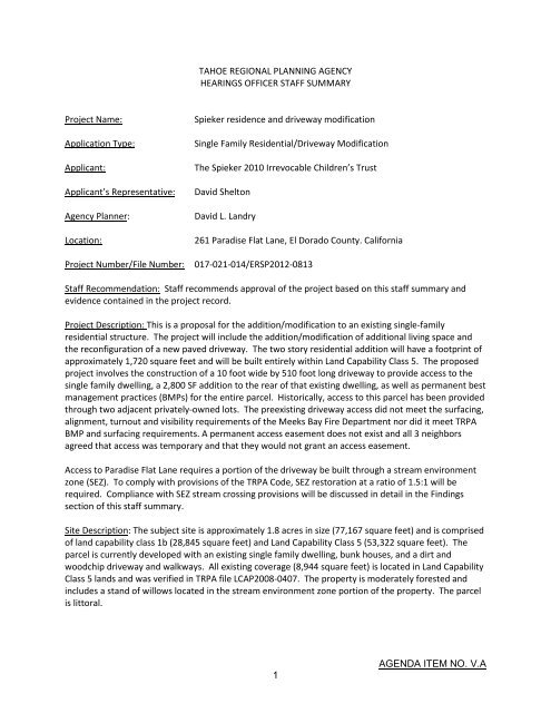
Project Name:<br />
Application Type:<br />
Applicant:<br />
Applicant’s Representative:<br />
Agency Planner:<br />
Location:<br />
Project Number/File Number:<br />
Spieker residence and driveway modification<br />
Single Family Residential/Driveway Modification<br />
The Spieker 2010 Irrevocable Children’s Trust<br />
David Shelton<br />
David L. Landry<br />
261 Paradise Flat Lane, El Dorado County. California<br />
017-021-014/ERSP<strong>2012</strong>-0813<br />
Staff Recommendation: Staff recommends approval of the project based on this staff summary and<br />
evidence contained in the project record.<br />
Project Description: This is a proposal for the addition/modification to an existing single-family<br />
residential structure. The project will include the addition/modification of additional living space and<br />
the reconfiguration of a new paved driveway. The two story residential addition will have a footprint of<br />
approximately 1,720 square feet and will be built entirely within Land Capability Class 5. The proposed<br />
project involves the construction of a 10 foot wide by 510 foot long driveway to provide access to the<br />
single family dwelling, a 2,800 SF addition to the rear of that existing dwelling, as well as permanent best<br />
management practices (BMPs) for the entire parcel. Historically, access to this parcel has been provided<br />
through two adjacent privately-owned lots. The preexisting driveway access did not meet the surfacing,<br />
alignment, turnout and visibility requirements of the Meeks Bay Fire Department nor did it meet TRPA<br />
BMP and surfacing requirements. A permanent access easement does not exist and all 3 neighbors<br />
agreed that access was temporary and that they would not grant an access easement.<br />
Access to Paradise Flat Lane requires a portion of the driveway be built through a stream environment<br />
zone (SEZ). To comply with provisions of the TRPA Code, SEZ restoration at a ratio of 1.5:1 will be<br />
required. Compliance with SEZ stream crossing provisions will be discussed in detail in the Findings<br />
section of this staff summary.<br />
Site Description: The subject site is approximately 1.8 acres in size (77,167 square feet) and is comprised<br />
of land capability class 1b (28,845 square feet) and Land Capability Class 5 (53,322 square feet). The<br />
parcel is currently developed with an existing single family dwelling, bunk houses, and a dirt and<br />
woodchip driveway and walkways. All existing coverage (8,944 square feet) is located in Land Capability<br />
Class 5 lands and was verified in TRPA file LCAP2008-0407. The property is moderately forested and<br />
includes a stand of willows located in the stream environment zone portion of the property. The parcel<br />
is littoral.<br />
1<br />
AGENDA ITEM NO. V.A
Paradise Flat Lane, a private road, provides access to the parcels located in this area of the subdivision.<br />
Paradise Flat Lane is located to the west of the parcel, adjacent to the SEZ.<br />
Issues: The proposed project additional coverage in excess of 1,000 square feet in land capability<br />
district 1b and therefore requires <strong>Hearings</strong> <strong>Officer</strong> review in accordance with Chapter 4, Appendix A, of<br />
the TRPA Code.<br />
Staff Analysis:<br />
A. Environmental Documentation: The applicant has completed an Initial Environmental Checklist<br />
(IEC) in order to assess the potential environmental impacts of the project. No significant<br />
environmental impacts were identified and staff has concluded that the project will not have a<br />
significant effect on the environment. A copy of the completed IEC will be made available at the<br />
<strong>Hearings</strong> <strong>Officer</strong> hearing and at TRPA.<br />
B. Plan Area Statement: The project area is located within the Paradise Flat Plan Area Statement –<br />
PAS 147. The Land Use Classification is Residential and the Management Strategy is Mitigation.<br />
Agency staff has determined that the project is consistent with the applicable planning<br />
statement, planning considerations, and special policies. The proposed driveway is accessory to<br />
the existing single family dwelling which is an allowed use in the PAS.<br />
C. Land Coverage:<br />
1. Land Capability District: The parcel consists of 52,322 square feet of land capability district 5<br />
and 28,845 square feet of land capability district 1b.<br />
2. Existing Coverage: TRPA File LCAP2008-0407 verified 8,944 square feet of existing Class 5<br />
coverage.<br />
3. Base Allowable Coverage: The parcel has 13,081 square feet of Class 5 base allowable<br />
coverage and 248 square feet of Class 1b base allowable coverage.<br />
4. Proposed Coverage: Total proposed coverage for the project is 12,177 square feet in Class 5<br />
and 2,513 square feet in Class 1b. All coverage proposed in Class 1b shall be mitigated by<br />
the restoration of stream environment lands in a ratio of 1.5 to 1, or 3,368 square feet<br />
pursuant to Subsection <strong>30</strong>.4.B.(1)(b).<br />
In order to provide appropriate ingress and egress for fire district personnel, the Meeks Bay<br />
Fire Department is requiring a turnout and turnaround as part of the proposed driveway.<br />
Per a memorandum written by the Lake <strong>Tahoe</strong> Basin Fire Chiefs and the <strong>Tahoe</strong> <strong>Regional</strong><br />
<strong>Planning</strong> Agency, dated July 23, 2008, the applicant has the choice “…to either make<br />
adjustments and build with their remaining base allowable coverage, relocate coverage onsite,<br />
or transfer into the property the minimum necessary to comply with health and safety<br />
requirements.” There is no remaining base allowable Class 1b coverage, so the applicant<br />
will restore coverage per Subsection <strong>30</strong>.4.B.(1)(b). However, for the coverage in Class 5<br />
lands, the applicant may either transfer in the coverage, pursuant to TRPA transfer<br />
regulations or remove this amount from their base allowable coverage.<br />
2<br />
AGENDA ITEM NO. V.A
5. Resultant Coverage and Water Quality Mitigation Fees.<br />
Base Allowable Coverage Only. If the applicant decides not to transfer the coverage in, then<br />
proposed coverage and fees are as follows:<br />
Class 5 = 12,177 square feet of coverage<br />
Class 1b = 2,513 square feet<br />
The parcel will have 48 square feet of Class 5 base allowable coverage remaining and no<br />
Class 1b base allowable remaining. No excess coverage fee is required pursuant to<br />
Subsection <strong>30</strong>.4.B.(1)(b). A water quality mitigation fee for the creation of 3,233 square feet<br />
of land coverage will be assessed at a cost of $1.86 per square foot, or $6,013.38. This<br />
amount of land coverage is the difference between the coverage previously verified (8,944<br />
square feet) and the coverage proposed (12,177 square feet).<br />
Required Findings: The following is a list of the required findings as set forth in Chapter 4, 21, and <strong>30</strong> of the<br />
TRPA Code of Ordinances. Following each finding, Agency staff has indicated if there is sufficient evidence<br />
contained in the record to make the applicable findings or has briefly summarized the evidence on which the<br />
finding can be made.<br />
1. Chapter 4 – Required Findings:<br />
(a)<br />
The project is consistent with and will not adversely affect implementation of the <strong>Regional</strong> Plan,<br />
including all applicable Goals and Policies, Plan Area Statements and maps, the Code and other<br />
TRPA plans and programs.<br />
(1) Land Use: The proposed driveway will serve an existing single family dwelling.<br />
Single family homes are an allowed use in the Paradise Flat Plan Area<br />
Statement.<br />
(2) Transportation: The project does not create any additional permanent daily<br />
vehicle trip ends (dvte). No significant impacts to Level of Service or <strong>Regional</strong> or<br />
Sub-<strong>Regional</strong> air quality are anticipated based on the IEC.<br />
(3) Conservation: This project will not adversely affect implementation of the<br />
Conservation Element of the <strong>Regional</strong> Plan. Best Management Practices (BMPs)<br />
will capture storm runoff and infiltrate the volume of water onsite. The project<br />
will be required to restore SEZ in the amount of 1.5 times the area of stream<br />
environment zone which is disturbed by the project. There are no known<br />
cultural or historic resources that would be affected by this project.<br />
(4) Recreation: The proposed project should have no effect on the recreational<br />
opportunities in the Lake <strong>Tahoe</strong> Basin.<br />
(5) Public Service Facilities: As a result of the project, the subject parcel shall be<br />
adequately served by existing public services and facilities. Paradise Flat Lane is<br />
3<br />
AGENDA ITEM NO. V.A
not currently paved, but may be as a condition of the draft permit, per TRPA<br />
Code Chapter 32.<br />
(6) Implementation: The project requires no additional development allocations<br />
and is consistent with the Implementation Element of the <strong>Regional</strong> Plan.<br />
(b)<br />
The project will not cause the environmental threshold carrying capacities to be exceeded.<br />
TRPA staff has completed the “Project Review Conformance Checklist and Article V(g) Findings”<br />
in accordance with Chapter 4, Subsection 4.3 of the TRPA Code of Ordinances. All responses<br />
contained on said checklist indicate compliance with the environmental threshold carrying<br />
capacities. Also, the applicant has completed an Initial Environmental Checklist (IEC). No<br />
significant environmental impacts were identified and staff has concluded that the project will<br />
not have a significant effect on the environment. A copy of the completed checklist and IEC will<br />
be made available at the <strong>Hearings</strong> <strong>Officer</strong> hearing and at TRPA.<br />
(c)<br />
Wherever federal, state or local air and water quality standards applicable for the Region,<br />
whichever are strictest, must be attained and maintained pursuant to Article V(g) of the TPRA<br />
Compact, the project meets or exceeds such standards.<br />
All potential effects are temporary and shall be mitigated through temporary and permanent<br />
Best Management Practices. The applicant will meet or exceed all federal, state, or local water<br />
quality standards. Upon completion of construction, the projects will have no impact upon<br />
water quality standards.<br />
2. Chapter <strong>30</strong>.4.5 - Relocation of Land Coverage<br />
(a)<br />
The relocation is to an equal or superior portion of the parcel or project area, as<br />
determined by reference to the following factors:<br />
(1) Whether the area of relocation already has been disturbed;<br />
The areas targeted for coverage relocation are areas of previous disturbance.<br />
(2) The slope of and natural vegetation on the area of relocation;<br />
The slope is consistent across the site and areas which are targeted for<br />
relocated coverage have been previously disturbed and thus natural vegetation<br />
will not be disturbed.<br />
(3) The fragility of the soil on the area of relocation;<br />
The proposed site has Land Capability Class 5 and 1b. Areas targeted for coverage<br />
relocation are located in Land Capability 1b where there is no reasonable alternative<br />
that avoids or reduces the extent of encroachment in the stream environment zone.<br />
(4) Whether the area of relocation appropriately fits the scheme of use of the<br />
property;<br />
4<br />
AGENDA ITEM NO. V.A
The area of relocation fits the scheme of the use of the property in that the<br />
relocation will aid in creating a single access point to the single family residence.<br />
(5) The relocation does not further encroach into a stream environment zone,<br />
backshore, or the setbacks established in the Code for the protection of stream<br />
environment zones or backshore;<br />
The relocation does not increase the extent of the encroachment into stream<br />
environment zone in that the relocation is from one point in the SEZ to another.<br />
(6) The project otherwise complies with the land coverage mitigation program set<br />
forth in Section <strong>30</strong>.6;<br />
Other than the relocation of coverage within the SEZ, the project complies with<br />
code subsection <strong>30</strong>.6 in that the residential addition will be located with Land<br />
Capability Class 5.<br />
(b)<br />
The area from which the land coverage was removed for relocation is restored in<br />
accordance with Subsection <strong>30</strong>.5.3.<br />
The impacts of the land coverage relocation will be fully mitigated through the<br />
restoration of stream environment lands at a ratio of 1:1.5 or a total of 3,368 square<br />
feet.<br />
(c)<br />
The relocation is not to Land Capability Districts 1a, 1b, 1c, 2 or 3, from any higher<br />
numbered land capability district.<br />
The relocation is from one portion of the SEZ to another and not to or from a higher<br />
land capability<br />
(d)<br />
If the relocation is from one portion of a SEZ to another portion, there is a<br />
net environmental benefit to the SEZ.<br />
The relocation from one portion of the SEZ to another is an improvement in that relocation will<br />
aid in consolidating two driveway points of entry into one with improved BMPs.<br />
3. Chapter <strong>30</strong>.5.2 Findings:<br />
(a)<br />
Stream Crossings. Land coverage and disturbance for projects to effect access across<br />
stream environment zones to otherwise buildable sites, if such projects otherwise<br />
comply with applicable development standards in Chapter 32, may be permitted in Land<br />
Capability District 1b (stream environment zones) if TRPA finds that:<br />
(1) There is no reasonable alternative, including relocation, which avoids or reduces<br />
the extent of encroachment in the stream environment zone, or that<br />
encroachment is necessary to reach the building site recommended by<br />
Individual Parcel Evaluation Score (IPES).<br />
5<br />
AGENDA ITEM NO. V.A
The stream environment zone runs north to south across the western portion of<br />
the parcel between the existing residence and Paradise Flat Lane. The existing<br />
residence is built in high land capability land. There are no other options for onsite<br />
access to the existing residence. Primarily because the previous access was<br />
never a formalized access and was done on a temporary agreement between<br />
the neighbors. The understanding at that time was that the access across the<br />
adjoining lots would be terminated upon sale of the subject lot or when the<br />
prior owner passes away. The prior owner has passed on and the property has<br />
been sold.<br />
The new owner is a trust, with the same trustee as the neighboring property to<br />
the north, but a unique and separate entity and the subject property was<br />
purchased as an independent property that was to remain independent.<br />
The previous access was on a wood chip driveway that meandered through<br />
trees on the two lots to the north. That access did not meet the surfacing or<br />
Best Management Practice requirements of TRPA.<br />
(2) The impacts of land coverage and disturbance are fully mitigated in the manner<br />
set forth in Subparagraph <strong>30</strong>.4.A(2)(e), with the exception that the restoration<br />
requirement in such Subsection shall apply exclusively to stream environment<br />
zone lands and shall include coverage and disturbance within the permitted<br />
Bailey coefficients.<br />
The proposed project involves the creation of 2,491 square feet of coverage in<br />
Class 1b. This coverage will be fully mitigated by the restoration of stream<br />
environment lands in a ratio of 1.5 to 1, or 3,368 square feet of SEZ restoration.<br />
Required Actions: Staff recommends that the <strong>Hearings</strong> <strong>Officer</strong> take the following actions:<br />
I. Approve the findings contained in this staff summary, and a finding of no significant<br />
environmental effect.<br />
II.<br />
Approve the project, based on the staff summary, subject to the conditions contained in<br />
the attached Draft TRPA Permit.<br />
6<br />
AGENDA ITEM NO. V.A
Attachment A - Draft Permit<br />
PROJECT DESCRIPTION: Residential Addition APN: 017-021-14<br />
PERMITTEES: The Spieker 2010 Irrevocable Children’s Trust FILE: #ERSP<strong>2012</strong>-0813<br />
COUNTY/LOCATION:<br />
El Dorado County / 261 Paradise Flat Lane<br />
Having made the findings required by Agency ordinances and rules, TRPA <strong>Hearings</strong> <strong>Officer</strong> approved the<br />
project on <strong>August</strong> <strong>30</strong>, <strong>2012</strong>, subject to the standard conditions of approval attached hereto<br />
(Attachment Q) and the special conditions found in this permit.<br />
This permit shall expire on <strong>August</strong> <strong>30</strong>, 2015, without further notice unless the construction has<br />
commenced prior to this date and diligently pursued thereafter. Commencement of construction<br />
consists of pouring concrete for a foundation and does not include grading, installation of utilities or<br />
landscaping. Diligent pursuit is defined as completion of the project within the approved construction<br />
schedule. The expiration date shall not be extended unless the project is determined by TRPA to be the<br />
subject of legal action which delayed or rendered impossible the diligent pursuit of the permit.<br />
NO TREE REMOVAL, CONSTRUCTION OR GRADING SHALL COMMENCE UNTIL:<br />
(1) TRPA RECEIVES A COPY OF THIS PERMIT UPON WHICH THE PERMITTEE(S) HAS ACKNOWLEDGED<br />
RECEIPT OF THE PERMIT AND ACCEPTANCE OF THE CONTENTS OF THE PERMIT;<br />
(2) ALL PRE-CONSTRUCTION CONDITIONS OF APPROVAL ARE SATISFIED AS EVIDENCED BY TRPA’S<br />
ACKNOWLEDGEMENT OF THIS PERMIT;<br />
(3) THE PERMITTEE OBTAINS A COUNTY BUILDING PERMIT. TRPA’S ACKNOWLEDGEMENT IS<br />
NECESSARY TO OBTAIN A COUNTY BUILDING PERMIT. THE COUNTY PERMIT AND THE TRPA<br />
PERMIT ARE INDEPENDENT OF EACH OTHER AND MAY HAVE DIFFERENT EXPIRATION DATES<br />
AND RULES REGARDING EXTENSIONS; AND<br />
(4) A TRPA PRE-GRADING INSPECTION HAS BEEN CONDUCTED WITH THE PROPERTY OWNER<br />
AND/OR THE CONTRACTOR.<br />
TRPA Executive Director/Designee<br />
Date<br />
PERMITTEES’ ACCEPTANCE: I have read the permit and the conditions of approval and understand and<br />
accept them. I also understand that I am responsible for compliance with all the conditions of the<br />
permit and am responsible for my agents’ and employees’ compliance with the permit conditions. I also<br />
understand that if the property is sold, I remain liable for the permit conditions until or unless the new<br />
owner acknowledges the transfer of the permit and notifies TRPA in writing of such acceptance. I also<br />
understand that certain mitigation fees associated with this permit are non-refundable once paid to<br />
TRPA. I understand that it is my sole responsibility to obtain any and all required approvals from any<br />
other state, local or federal agencies that may have jurisdiction over this project whether or not they are<br />
listed in this permit.<br />
Signature of Permittee(s)<br />
Date<br />
(PERMIT CONTINUED ON NEXT PAGE)<br />
7<br />
AGENDA ITEM NO. V.A
D-R-A-F-T<br />
APN 017-021-14<br />
FILE NO. ERSP<strong>2012</strong>-0813<br />
Water Quality Mitigation Fee (1): Amount $ Paid Receipt No.<br />
Offsite Coverage Mitigation Fee (2): Amount $_______ Paid _____ Receipt No.______<br />
Security Posted (3): Amount $ Type Paid Receipt No.<br />
Security Administrative Fee (4): Amount $ Paid Receipt No.<br />
Notes:<br />
(1) Amount to be determined. See Special Condition 3.C., below.<br />
(2) See Special Condition 3.D., below<br />
(3) Amount to be determined. See Special Condition 3.E., below<br />
(4) $152 if a cash security is posted or $135 of a non-cash security is posted.<br />
Required plans determined to be in conformance with approval: Date:<br />
TRPA ACKNOWLEDGEMENT: The permittee has complied with all pre-construction conditions of<br />
approval as of this date and is eligible for a county building permit:<br />
TRPA Executive Director/Designee<br />
Date<br />
SPECIAL CONDITIONS<br />
1. This permit specifically authorizes the construction of a two story addition to an existing single<br />
family residential structure and the building of a reconfigured driveway to access the existing<br />
single family home at 261 Paradise Flat Lane, El Dorado County, California. All temporary and<br />
permanent BMPs shall be installed as a part of this project.<br />
2. The Standard Conditions of Approval listed in Attachment R shall apply to this permit.<br />
3. Prior to final permit acknowledgement the following conditions of approval shall be satisfied.<br />
A. The site plan shall be revised to include:<br />
(1) Clear indication of areas to be re-vegetated.<br />
(2) Construction staging area.<br />
(3) Amount of off-site coverage.<br />
B. The permittee shall submit a projected construction completion schedule to TRPA prior<br />
to acknowledgment. Said schedule shall include completion dates for each item of<br />
8<br />
AGENDA ITEM NO. V.A
construction and demonstrating completion by Oct 15 th of each construction season.<br />
C. If the permittee selects to use available base allowable coverage for the coverage<br />
required by the fire department, a water quality mitigation fee of $6,013.38 will be<br />
required. This fee is based on the creation of 3,233 square feet of land coverage at<br />
$1.86 per square foot.<br />
D. The permittee shall pay an Offsite Coverage Mitigation fee of $6,409 for the creation of<br />
754 square feet of land coverage in the public right-of-way at $8.50/sf.<br />
E. The security required under Standard Condition A.3 of Attachment R and Section 8.8 of<br />
the TRPA Code of Ordinances shall be determined upon the permittee’s submittal of<br />
required Best Management Practices plan and related cost estimate. The security shall<br />
be equal to 110 percent of the cost estimate. The security shall also be no less than<br />
$5,000. Please see Attachment J, Security Procedures for appropriate ways to post the<br />
security and for calculation of the required Security Administrative Fee.<br />
F. The permittee shall provide proof of restoration of 3,368 square feet of stream<br />
environment zone.<br />
G. The permittee shall provide proof that the parcel is served by a paved road, unless<br />
waived by Section 32.3.1.C.<br />
H. The permittee shall submit construction methodology that provides information on how<br />
the construction of the road will limit disturbance to the SEZ. Any additional permanent<br />
disturbance to the SEZ caused by installation of the driveway shall be required to be<br />
mitigated by SEZ restoration at a ratio of 1.5 to 1 prior to return of permit security.<br />
I. The permittee shall provide (3) three sets of the final plans for TRPA acknowledgement.<br />
4. To the maximum extent allowable by law, the Permittee agrees to indemnify, defend, and hold<br />
harmless TRPA, its Governing Board, its <strong>Planning</strong> Commission, its agents, and its employees<br />
(collectively TRPA) from and against any and all suits, losses, damages, injuries, liabilities, and<br />
claims by any person (a) for any injury (including death) or damage to person or property or (b)<br />
to set aside, attack, void, modify, amend, or annul any actions of any TRPA. The foregoing<br />
indemnity obligation applies, without limitation, to any and all suits, losses, damages, injuries,<br />
liabilities, and claims by any person from any cause whatsoever arising out of or in connection<br />
with either directly or indirectly, and in whole or in part (1) the processing, conditioning,<br />
issuance, or implementation of this permit; (2) any failure to comply with all applicable laws and<br />
regulations; or (3) the design, installation, or operation of any improvements, regardless of<br />
whether the actions or omissions are alleged to be caused by TRPA or Permittee.<br />
Included within the Permittee's indemnity obligation set forth herein, the Permittee agrees to<br />
pay all fees of TRPA’s attorneys and all other costs and expenses of defenses as they are<br />
incurred, including reimbursement of TRPA as necessary for any and all costs and/or fees<br />
incurred by TRPA for actions arising directly or indirectly from issuance or implementation of<br />
this permit. Permittee shall also pay all costs, including attorneys’ fees, incurred by TRPA to<br />
enforce this indemnification agreement. If any judgment is rendered against TRPA in any action<br />
9<br />
AGENDA ITEM NO. V.A
subject to this indemnification, the Permittee shall, at its expense, satisfy and discharge the<br />
same.<br />
5. Any and all waste resulting from the saw-cutting of pavement shall be removed using a vacuum<br />
(or other TRPA-approved method) during the cutting process or immediately thereafter.<br />
Discharge of waste material to surface drainage features is prohibited and constitutes a<br />
violation of this permit.<br />
6. Temporary erosion control structures must be maintained until disturbed areas are stabilized.<br />
Temporary erosion control structures shall be removed once the site has been stabilized.<br />
7. Any normal construction activity creating noise in excess of the TRPA noise standards shall be<br />
considered exempt from said standards provided all such work is conducted between the hours<br />
of 8:00 A.M. and 6:<strong>30</strong> P.M.<br />
END OF PERMIT<br />
10<br />
AGENDA ITEM NO. V.A
TAHOE REGIONAL PLANNING AGENCY<br />
HEARINGS OFFICER STAFF SUMMARY<br />
Project Name:<br />
Application Type:<br />
Applicant:<br />
Applicant’s Representative:<br />
Agency Planner:<br />
Location:<br />
Finney Single Family Residential Rebuild<br />
Single Family Residential<br />
John and Jeanette Finney<br />
Ogilvy Consulting<br />
Wendy Jepson, Senior Planner<br />
1715 Lakeshore Boulevard (SR28), Washoe County, NV<br />
Project Number/File Number: ERSP<strong>2012</strong>-0757 / 1<strong>30</strong>-331-06<br />
Staff Recommendation: Staff recommends approval of the project based on this staff summary and<br />
evidence contained in the project record.<br />
Project Description: The proposed project includes the demolition of a single family residence and<br />
garage, and construction of a new residence and garage connected by an elevated covered and<br />
conditioned breezeway. On the lake-side of the parcel, a lap pool, renovation to the existing deck and a<br />
new planting area will be constructed. The project will utilize and relocate existing verified coverage<br />
and, although the overall square footage of the new residence will increase over the existing, due to the<br />
height of the elevated walkway and the number of stories proposed, overall the coverage will be<br />
reduced. Fourteen trees less than 24 inches in diameter will be removed. Best management practices<br />
include a metal slotted drain along the front of the paved driveway to capture storm water runoff and<br />
channel it into two infiltration galleries; gutters will channel storm water from the roof into four<br />
additional infiltration galleries, and drip line infiltration trenches on the north side. A shoreland scenic<br />
analysis has been conducted for the lakefront parcel, and a scenic simulation was prepared to analyze<br />
impacts to the scenic roadway unit.<br />
Site Description: This lakefront property is in the Rocky Point subdivision, located on State Route 28 in<br />
Incline Village, within the East Shore Plan Area Statement (055). Single family dwellings are special uses<br />
in the plan area. It is visible from and located within Shoreline Scenic Unit 23, Crystal Bay, a nonattainment<br />
area, and Roadway Unit 26, Sand Harbor, which is in attainment. The approximately onequarter<br />
acre lot contains land capability districts 1b and 2, is long, narrow (187 by 55 feet) and fairly<br />
steep with a slope across the building section of approximately eighteen (18) percent. The existing twostory<br />
residence and garage were constructed in 1949. TRPA evaluated the structure’s historic<br />
significance, land coverage and land capability. No historic significance was identified, and 4,714 square<br />
feet of existing land coverage was verified in land capability districts 1b and 2. Demolition was<br />
authorized subject to a qualified exempt approval although at this writing the building has not been<br />
demolished.<br />
Issues: The primary project related issues are:<br />
1 AGENDA ITEM NO. V.B.
- Reduced setback from roadway. TRPA Code of Ordinances Section 36.5.4, Setback Standards,<br />
requires a 20’ minimum building setback from the right of way for parcels abutting scenic<br />
roadways. TRPA may approve a reduced setback if the setback is approved by the local jurisdiction<br />
and if TRPA finds that the project will not cause a decrease in the numerical rating assigned to the<br />
roadway unit.<br />
- Scenic Quality. As the new construction will be visible from both a scenic roadway unit and scenic<br />
shoreline unit, simulations and a scenic analysis of the lakefront development have been prepared<br />
to evaluate the potential impacts to scenic quality.<br />
- Grading and construction techniques. This project area contains steep slopes and sensitive soils<br />
classifications, and a proposed pool that will be constructed partially in the previously disturbed<br />
backshore area.<br />
Staff Analysis:<br />
A. Environmental Documentation: The applicant has completed rational for the required findings,<br />
which are detailed below. TRPA staff has completed a project review conformance checklist and<br />
V (g) findings to evaluate the project’s impacts on the thresholds, and a copy of the completed<br />
checklist will be made available at the <strong>Hearings</strong> <strong>Officer</strong> hearing and at TRPA.<br />
B. Plan Area Statement: Plan Area Statement 055, East Shore, lists single family residential as a<br />
special use. Although the site has been used for single family residential since the existing<br />
building was constructed in 1949, special use findings have not been made prior to this report.<br />
The project will satisfy the requirements of those findings.<br />
C. Land Coverage: This project complies with land coverage requirements of the TRPA Code of<br />
Ordinances.<br />
D. Height: This project complies with height requirements of the TRPA Code of Ordinances.<br />
Required Findings: The following is a list of the required findings as set forth in Chapter 4, 21, <strong>30</strong>, 33, 36, 37 and<br />
84 of the TRPA Code of Ordinances. Following each finding, Agency staff has indicated if there is sufficient<br />
evidence contained in the record to make the applicable findings or has briefly summarized the evidence on<br />
which the finding can be made.<br />
1. Chapter 4 – Required Findings:<br />
(a)<br />
The project is consistent with and will not adversely affect implementation of the <strong>Regional</strong> Plan,<br />
including all applicable Goals and Policies, Plan Area Statements and maps, the Code and other<br />
TRPA plans and programs.<br />
Based on the findings provided and the Article V (g) Findings Checklist, there is sufficient<br />
evidence in the project file to make this finding.<br />
(b)<br />
The project will not cause the environmental threshold carrying capacities to be exceeded.<br />
TRPA staff has completed the “Project Review Conformance Checklist and Article V (g) Findings”<br />
in accordance with Chapter 4, Subsection 4.3 of the TRPA Code of Ordinances. All responses<br />
contained on said checklist indicate compliance with the environmental threshold carrying<br />
2 AGENDA ITEM NO. V.B.
capacities. No significant environmental impacts were identified and staff has concluded that<br />
the project will not have a significant effect on the environment. A copy of the completed<br />
checklist will be made available at the <strong>Hearings</strong> <strong>Officer</strong> hearing and at TRPA.<br />
(c)<br />
Wherever federal, state or local air and water quality standards applicable for the Region,<br />
whichever are strictest, must be attained and maintained pursuant to Article V (g) of the TPRA<br />
Compact, the project meets or exceeds such standards.<br />
All potential effects are temporary and shall be mitigated through temporary and permanent<br />
Best Management Practices. The applicant will meet or exceed all federal, state, or local water<br />
quality standards. Upon completion of construction, the projects will have no impact upon<br />
water quality standards.<br />
2. Chapter 21 – Special Use Findings:<br />
(a)<br />
The project, to which the use pertains, is of such a nature, scale, density, intensity and type to<br />
be an appropriate use for the parcel on which, and surrounding area in which, it will be located.<br />
The project does not propose any change in use and the parcel will remain singlefamily<br />
residential. The property is bound by existing residential uses to the north and<br />
south, and across State Highway 28 to the east.<br />
The new residence and garage will be constructed largely over the footprint of the<br />
existing residence and garage, keeping the size of the footprint approximately the same<br />
as the existing residence. The new residence is taller than the existing residence but due<br />
to the large specimen trees and vegetation located at the site, in addition to the steep<br />
slope of the lot, the proposed structure will not extend beyond the forest canopy as<br />
viewed from Lake <strong>Tahoe</strong>. The similar size of the existing and proposed structures in<br />
addition to the coverage reduction ensures that the rebuilt residence and garage will be<br />
of appropriate nature, scale, density and intensity for the parcel and surrounding area.<br />
(b)<br />
The project to which the use pertains, will not be injurious or disturbing to the health, safety,<br />
enjoyment of property, or general welfare of persons or property in the neighborhood, or<br />
general welfare of the region, and the applicant has taken reasonable steps to protect against<br />
any such injury and to protect the land, water, and air resources of both the applicant’s property<br />
and that of surrounding property owners.<br />
The new residence and garage will be built to current building code requirements and updated<br />
BMP’s will be installed to meet water quality requirements. These improvements and the<br />
continuation of the established residential use will not injurious or disturbing to the health,<br />
safety, enjoyment of property, or general welfare of persons or property in the neighborhood,<br />
or general welfare of the region.<br />
(c)<br />
The project, to which the use pertains, will not change the character of the neighborhood<br />
detrimentally affect or alter the purpose of the applicable planning area statement, community<br />
plan and specific or master plan, as the case may be.<br />
3 AGENDA ITEM NO. V.B.
The project will maintain the established residential use, which will not change the<br />
character of the neighborhood, or detrimentally affect or alter the purpose of the<br />
applicable plan area statement.<br />
3. Chapter <strong>30</strong>.4.5 - Relocation of Land Coverage<br />
(a)<br />
The relocation is to an equal or superior portion of the parcel or project area, as<br />
determined by reference to the following factors:<br />
(1) Whether the area of relocation already has been disturbed;<br />
The subject project proposes to relocate 91 square feet of coverage within the Class<br />
1b Backshore while maintaining 605 square feet of existing coverage. Of the<br />
proposed relocated 1b coverage, 68square feet is proposed to be built on existing<br />
deck poles and located over existing boulders. Construction will require minimal to<br />
no disturbance. The remaining 23square feet is will be located within areas that<br />
have been previously disturbed. The relocated land coverage would be mitigated at<br />
a 1.5:1 ratio.<br />
The project also proposes to relocate approximately 1,443 square feet of coverage<br />
within the Class 2 land capability district. The majority of this area of the new<br />
relocated coverage was previously disturbed by the original construction of the<br />
residence, continual use of the property, and landscape enhancements over many<br />
years.<br />
(2) The slope of and natural vegetation on the area of relocation;<br />
In the area of relocated 1b coverage, the shoreline and location of the deck consists<br />
of large boulders with little to no vegetation, and slopes steeply to the lake.<br />
The area of Class 2 relocated coverage is on a fairly steep slope with existing native<br />
vegetation, mainly small trees less than 14 inches in diameter that will be removed.<br />
(3) The fragility of the soil on the area of relocation;<br />
In the area of relocated 1b coverage, the shoreline and location of the deck consists<br />
of large boulders with little to no soil.<br />
The area of Class 2 relocated coverage is to areas with Class 2 soils. Temporary and<br />
permanent BMP’s will ensure the stability of the soil during and after construction.<br />
(4) Whether the area of relocation appropriately fits the scheme of use of the property;<br />
The relocated 1b land coverage fits the scheme of use of the property simply by<br />
repairing the existing deck and creating a safer layout allowing for are new railing<br />
and additional area for maneuvering along the deck. The relocation is at the furthest<br />
lakeside point of the existing deck, and would be at a higher elevation than the<br />
existing deck and therefore located further from the lake in its elevation. The<br />
4 AGENDA ITEM NO. V.B.
elocated class 2 will primarily be for the garage, which is being realigned to be a<br />
safer distance from the roadway.<br />
(5) The relocation does not further encroach into a stream environment zone,<br />
backshore, or the setbacks established in the Code for the protection of stream<br />
environment zones or backshore;<br />
A portion of the relocated 1b land coverage would further encroach into the<br />
backshore of Lake <strong>Tahoe</strong>. Because the relocated Class 1b land coverage creates<br />
further backshore encroachment, and this encroachment is not an equal or superior<br />
portion of the parcel, as special condition is included in the permit to remove the 68<br />
square feet of additional coverage in the backshore that was intended to be utilized<br />
as new decking.<br />
(6) The project otherwise complies with the land coverage mitigation program set forth<br />
in Section <strong>30</strong>.6;<br />
The relocated 1b area will be offset with the retirement of 46 square feet of<br />
coverage within the backshore and a total of 137 square feet of restored Class 1b<br />
area.<br />
(b)<br />
The area from which the land coverage was removed for relocation is restored in<br />
accordance with Subsection <strong>30</strong>.5.3.<br />
All areas of removed coverage will be restored in accordance with subsection <strong>30</strong>.5.3 of<br />
the TRPA Ordinance.<br />
(c)<br />
The relocation is not to Land Capability Districts 1a, 1b, 1c, 2 or 3, from<br />
any higher numbered land capability district.<br />
No coverage is being relocated from a lower land capability district to higher.<br />
(d)<br />
If the relocation is from one portion of a SEZ to another portion, there is a<br />
net environmental benefit to the SEZ.<br />
A total of 91 square feet of Class 1b coverage is being relocated. Per the 1.5:1<br />
mitigation requirement, 46 square feet of Class 1b coverage will be permanently retired,<br />
and a total of 137 square feet of relocated/retired coverage will be restored.<br />
4. Chapter 33.3.6 – Grading<br />
(a)<br />
A soils/hydrologic report prepared by a qualified professional, which proposed content<br />
and methodology has been reviewed and approved in advance by TRPA, demonstrates<br />
that no interference or interception of groundwater will occur as a result of the<br />
excavation;<br />
5 AGENDA ITEM NO. V.B.
A waiver to the requirement to conduct a subsurface investigation was approved on<br />
January 20, 2010 and an excavation depth was approved to 6233.75msl for the<br />
residence and to 6250 msl for the garage.<br />
(b)<br />
The excavation is designed such that no damage occurs to mature trees, except where<br />
tree removal is allowed pursuant to subsection 33.6.5: Tree Removal, including root<br />
systems and hydrologic conditions of the soil. To ensure the protection of vegetation<br />
necessary for screening, a special vegetation protection report shall be prepared by a<br />
qualified professional identifying measures necessary to ensure damage will not occur<br />
as a result of the excavation;<br />
Fourteen trees that are fourteen inches and less in diameter are proposed to be<br />
removed in order to construct the project. A special permit condition requires a report<br />
detailing the protection necessary for trees to be retained for screening and the impacts<br />
of the construction on those plants.<br />
(c)<br />
Excavated material is disposed of pursuant to subsection 33.3.4: Disposal of Materials,<br />
and the project area's natural topography is maintained pursuant to subparagraph<br />
36.5.1.A. If groundwater interception or interference will occur as demonstrated by a<br />
soils/hydrologic report prepared by a qualified professional, then the excavation can be<br />
made as an exception pursuant to subparagraph 33.3.6.A.2, provided measures are<br />
included in the project to maintain groundwater flows to avoid adverse impacts to SEZ<br />
vegetation and to prevent any groundwater or subsurface water flow from leaving the<br />
project area as surface flow.<br />
A special permit condition requires that the disposal location for excavated materials be<br />
identified in the grading plan.<br />
5. Chapter 36.5.4- Design Standards<br />
(a)<br />
TRPA may approve building setbacks less than 20 feet if the reduced setback is approved<br />
by the appropriate local jurisdiction and TRPA finds that the project shall not cause a<br />
decrease in the numerical ratings assigned to the roadway unit, including the scenic<br />
quality rating of the individual resources within each unit, as recorded in the 1982<br />
Scenic Resources Inventory and shown in Tables 13-3 and 13-8 of the Study Report for<br />
the Establishment of Environmental Threshold Carrying Capacities, October 1982. The<br />
criteria for rating scenic quality as identified in the study report cited herein shall be<br />
used to determine if a project will cause a decrease in the numerical rating.<br />
The proposed project has an existing garage built in 1967 under a Washoe County<br />
Building Permit that is approximately 11 feet from the right-of-way and within the 20-<br />
foot setback from the right-of-way of SR 28. Due to the steep slope of the lot and rocky<br />
conditions it is necessary to locate the garage as far up-slope as possible. The proposed<br />
garage is approximately 15 feet from the right-of-way, increasing the setback from the<br />
scenic corridor. The new garage will be constructed with natural stone façade and dark<br />
wood accents replacing the existing monotone garage. With a similar mass as the<br />
existing garage as viewed from the scenic travel route and an increased setback from<br />
existing conditions, the project will not cause a decrease in the numerical rating<br />
6 AGENDA ITEM NO. V.B.
6. Chapter 37- Height<br />
assigned to the roadway unit. A simulation, prepared to analyze the impact of the<br />
proposed structures from the roadway, confirms this finding.<br />
(a)<br />
When viewed from major arterials, scenic turnouts, public recreation areas or the<br />
waters of Lake <strong>Tahoe</strong>, from a distance of <strong>30</strong>0 feet, the additional height will not<br />
cause a building to extend above the forest canopy, when present, or a ridgeline.<br />
The proposed structure will be visible from Roadway Unit 26, Sand Harbor and Shoreline Unit<br />
23, Crystal Bay. The proposed project height of 40’6” will not extend above the forest canopy or<br />
ridgelines. Scenic analysis from both the roadway and the lake have assessed the project’s<br />
impacts and confirmed that the project meets this finding.<br />
(b)<br />
When outside a community plan, the additional height is consistent with the<br />
surrounding uses.<br />
The proposed residence is consistent with the surrounding uses. The proposed<br />
residence and garage are consistent with the recently reconstructed residence directly<br />
to the north. The design of the garage roof with the gable running parallel to SR 28<br />
reduces the visible height of the garage and is lower than the recently approved<br />
neighboring garage to the North. To the south the development is limited due to public<br />
lands. However to the north is the Mill Creek Plan Area that contains multiple<br />
residences of similar height.<br />
(c)<br />
The maximum building height at any corner of two exterior walls of the building is not greater<br />
than 90 percent of the maximum building height. The maximum height at the corner of two<br />
exterior walls is the difference between the point of lowest natural ground elevation along an<br />
exterior wall of the building, and point at which the corner of the same exterior wall meets the<br />
roof.<br />
The proposed residence has a maximum proposed height is 40’-6”. The northwest<br />
corner of the lakefront façade is 26’-8” or 64% of the maximum building height. Since<br />
the garage and residence are connected by enclosed breezeway they considered one<br />
structure and therefore only require this finding to be made for the highest corner of<br />
the entire structure.<br />
7. Chapter 84- Filling and Dredging<br />
(a)<br />
There shall be no fill placed in the lakezone or shorezone, except as otherwise associated with<br />
the approved bypass dredging, shoreline protective structures, or beach replenishments<br />
projects, or as otherwise found by TRPA to be beneficial to existing shorezone conditions or<br />
water quality and clarity.<br />
The proposed plantings are in a similar location of an existing planter within the<br />
backshore. The minimal fill associated with the planting of the proposed aspens in the<br />
backshore will be greatly offset by the long-term benefits of the trees. The location of<br />
the proposed trees is currently either concrete patio or backfill behind a deteriorating<br />
7 AGENDA ITEM NO. V.B.
etaining wall. The removal of the concrete patio will allow for more infiltration within<br />
the backshore. The new trees and associated root systems will help to stabilize the<br />
existing subgrade within the backshore and reduce potential erosion. Aspens are also<br />
associated with nitrogen-fixing bacteria in the soil, which helps to naturally fertilize the<br />
surrounding area eliminating the need for additional fertilizer. The additional pervious<br />
area, soil stabilization and natural fertilizing benefits of the aspen will be beneficial to<br />
the existing shorezone conditions and water quality.<br />
Required Actions: Staff recommends that the <strong>Hearings</strong> <strong>Officer</strong> take the following actions:<br />
I. Approve the findings contained in this staff summary, and a finding of no significant<br />
environmental effect.<br />
II.<br />
Approve the project, based on the staff summary, subject to the conditions contained in<br />
the attached Draft TRPA Permit.<br />
8 AGENDA ITEM NO. V.B.
(Attachment A) DRAFT PERMIT<br />
PROJECT DESCRIPTION: Single Family Dwelling Rebuild APN: 1<strong>30</strong>-331-06<br />
PERMITTEE(S): John and Jeannette Finney<br />
COUNTY/LOCATION: 1715 Lakeshore Blvd., Washoe County, Nevada<br />
FILE # ERSP<strong>2012</strong>-0757<br />
Having made the findings required by Agency ordinances and rules, the TRPA <strong>Hearings</strong> <strong>Officer</strong> approved<br />
the project on <strong>August</strong> <strong>30</strong>, <strong>2012</strong>, subject to the standard conditions of approval attached hereto<br />
(Attachment R), and the special conditions found in this permit.<br />
This permit shall expire on <strong>August</strong> <strong>30</strong>, 2015 without further notice unless the construction has<br />
commenced prior to this date and diligently pursued thereafter. Commencement of construction<br />
consists of pouring concrete for a foundation and does not include grading, installation of utilities or<br />
landscaping. Diligent pursuit is defined as completion of the project within the approved construction<br />
schedule. The expiration date shall not be extended unless the project is determined by TRPA to be the<br />
subject of legal action which delayed or rendered impossible the diligent pursuit of the permit.<br />
NO TREE REMOVAL, CONSTRUCTION OR GRADING SHALL COMMENCE UNTIL:<br />
(1) TRPA RECEIVES A COPY OF THIS PERMIT UPON WHICH THE PERMITTEE(S) HAS ACKNOWLEDGED RECEIPT OF THE PERMIT<br />
AND ACCEPTANCE OF THE CONTENTS OF THE PERMIT;<br />
(2) ALL PRE-CONSTRUCTION CONDITIONS OF APPROVAL ARE SATISFIED AS EVIDENCED BY TRPA’S ACKNOWLEDGEMENT OF<br />
THIS PERMIT;<br />
(3) THE PERMITTEE OBTAINS A COUNTY BUILDING PERMIT. TRPA’S ACKNOWLEDGEMENT IS NECESSARY TO OBTAIN A COUNTY<br />
BUILDING PERMIT. THE COUNTY PERMIT AND THE TRPA PERMIT ARE INDEPENDENT OF EACH OTHER AND MAY HAVE<br />
DIFFERENT EXPIRATION DATES AND RULES REGARDING EXTENSIONS; AND<br />
(4) A TRPA PRE-GRADING INSPECTION HAS BEEN CONDUCTED WITH THE PROPERTY OWNER AND/OR THE CONTRACTOR.<br />
_______________________________________ _______________________________<br />
TRPA Executive Director/Designee<br />
Date<br />
---------------------------------------------------------------------------------------------------------------------<br />
PERMITTEE’S ACCEPTANCE: I have read the permit and the conditions of approval and understand and<br />
accept them. I also understand that I am responsible for compliance with all the conditions of the permit<br />
and am responsible for my agents’ and employees’ compliance with the permit conditions. I also<br />
understand that if the property is sold, I remain liable for the permit conditions until or unless the new<br />
owner acknowledges the transfer of the permit and notifies TRPA in writing of such acceptance. I also<br />
understand that certain mitigation fees associated with this permit are non-refundable once paid to<br />
TRPA. I understand that it is my sole responsibility to obtain any and all required approvals from any<br />
other state, local or federal agencies that may have jurisdiction over this project whether or not they are<br />
listed in this permit.<br />
Signature of Permittee(s)___________________________ Date______________________<br />
-------------------------------------------------------------------------------------------------------------------------------<br />
PERMIT CONTINUED ON NEXT PAGE<br />
9 AGENDA ITEM NO. V.B.
APN: 1<strong>30</strong>-331-06<br />
FILE NO. ERSP<strong>2012</strong>-0757<br />
Excess Coverage Mitigation Fee (1):<br />
Additional Filing Fees (2):<br />
Amount $________ Paid _____ Receipt No.______<br />
Amount $_2,026.25 Paid _____ Receipt No.______<br />
Security Posted (3): Amount $ Type Paid Receipt No. ______<br />
Scenic Security Posted (4): Amount $ Type Paid Receipt No. ______<br />
Security Administrative Fee (5):<br />
Scenic Security Administrative Fee (5):<br />
Amount $ ________ Paid _______ Receipt No.______<br />
Amount $ ________ Paid _______ Receipt No.______<br />
Notes:<br />
(1) See Special Condition 3.J., below.<br />
(2) See Special Condition 3.K., below.<br />
(3) See Special Condition 3.L., below.<br />
(4) See Special Condition 3.I.(5), below<br />
(5) $152 if a cash security is posted, or $135 if a non-cash security is posted.<br />
Required plans determined to be in conformance with approval: Date: ______________<br />
TRPA ACKNOWLEDGEMENT: The permittee has complied with all pre-construction conditions of<br />
approval as of this date. _____________________________________<br />
________________________________<br />
TRPA Executive Director/Designee<br />
Date<br />
-------------------------------------------------------------------------------------------------------------------------------<br />
SPECIAL CONDITIONS<br />
1. This permit is issued to allow the demolition of a single family residence and garage, and<br />
construction of a new residence and garage connected by an elevated covered and conditioned<br />
breezeway. On the lake-side of the parcel, a lap pool, modifications to the existing deck and a<br />
new planting area will be constructed. New landscaping that includes sod, shrubs and trees will<br />
be incorporated around relocated granite boulders and existing native plants in the center of the<br />
property between the house and garage. The project will be constructed utilizing existing land<br />
coverage.<br />
2. The Standard Conditions of Approval listed in Attachment R shall apply to this permit.<br />
3. Prior to permit acknowledgement, the following conditions of approval shall be satisfied.<br />
A. The site plan sheets shall be revised to include:<br />
(1) Revised coverage calculation table on page SA-2 and associated site plan sheet<br />
to include the following modifications:<br />
10 AGENDA ITEM NO. V.B.
(a)<br />
(b)<br />
Verification that all of the coverage associated with the stone patio<br />
adjacent to the garage and under the garage decking, as shown on the<br />
landscape plan, and the blue stone steps from the street to the lawn<br />
area is included in the coverage table.<br />
Remove the notation referencing “occasional parking area” and the<br />
double line of blue stone pavers adjacent to south side of the garage<br />
and driveway. Bollards, boulders or other parking barrier shall be<br />
shown on the site plan to prevent “occasional parking” on this area.<br />
Alternatively, if this area is to be used for parking, best management<br />
practices shall be installed and the coverage calculations revised to<br />
account for the entire parking area as coverage.<br />
(2) All existing easements, if any.<br />
(3) Construction staging and excavation storage locations.<br />
(4) The landscape plan will detail revegetation for the areas where coverage is to be<br />
removed. All vegetation shall be consistent with the requirements of Chapter 36<br />
of the TRPA Code of Ordinances, including the specification for sizing and species<br />
of plants. The use of fertilizer shall be kept to a minimum and applied in<br />
accordance with Section 60.1.8 of the TRPA Code of Ordinances.<br />
(5) Indication that the disposal point of the pool drain and backwash will be to the<br />
sanitary sewer system. In no case will the pool be drained directly into Lake<br />
<strong>Tahoe</strong>.<br />
(6) A note stating that this permit does not approve pier construction or<br />
reconstruction of any kind.<br />
B. Provide revised building elevations, height calculations and a roof plan to demonstrate a<br />
maximum building height of 40’6”, based on a cross slope of 18 percent with a dominant<br />
roof pitch of 10:12 or greater. The existing grade low point will be measured from<br />
elevation 6,240.75.<br />
C. Provide a grading plan that includes:<br />
(1) Details and cross sections for the actual limits and depth of grading, not to<br />
exceed 6233.75 msl for the residence and 6250 msl for the garage, the areas of<br />
cut and fill and the amount, the depth of cut and width required for the pool and<br />
planting area, and slope stabilization for the areas of cut. Include all existing and<br />
proposed finish floor elevation points and contour elevations.<br />
(2) Revise the slope of the driveway so that stormwater will flow away from the<br />
roadway and install BMP’s to capture that drainage. No fills or recontouring,<br />
other than backfill for the cut-retaining structures, is allowed.<br />
(3) An evaluation with recommendations as to construction techniques, by a<br />
qualified professional, of the effects of the grading on existing trees and impacts<br />
to trees to be retained for screening, particularly the 38” pine, 27” pine, and 10”<br />
cedar on the north side, and the Chinqu on the south side of the property.<br />
Those recommendations will be incorporated into the grading and demolition<br />
plans.<br />
(4) A TRPA approved location for disposal of excavated material.<br />
11 AGENDA ITEM NO. V.B.
D. A detailed construction and demolition plan submitted for TRPA approval that describes<br />
the demolition and construction methodology, the phasing and timing, and traffic<br />
control measures that will be necessary to control vehicular ingress and egress.<br />
E. The proposed temporary BMP Plan shall be revised to include:<br />
(1) Construction and vegetation fencing around the area between the garage and<br />
house that is proposed to be undisturbed.<br />
(2) Vegetation fencing shall be located around the drip line of all trees that are to<br />
remain in place, particularly the 38” pine, 27” pine, and 10” cedar on the north<br />
side of the property, and the Chinqu on the south side of the property that are<br />
utilized as screening for scenic mitigation. Notation C on BMP-3 will be revised<br />
so that there will be no pruning of any tree or shrub providing scenic mitigation.<br />
(3) Additional erosion control fencing along the contour between the garage and<br />
house.<br />
(4) Gravel or pine-needle filled waddles placed among the boulders lakeward of the<br />
west side of the house. These erosion control devices will be placed based on<br />
approval of the TRPA pre-grade inspector.<br />
(5) A notation that turbidity fencing will only be installed at the request of a TRPA<br />
inspector.<br />
F. The proposed permanent BMP Plan shall be revised to include:<br />
(1) Retention and treatment of stormwater runoff from the driveway so that it does<br />
not run into the Highway 28 right of way. Alternatively, revise the slope of the<br />
driveway to drain into the parcel, away from the road.<br />
(2) Retention of stormwater runoff from the lower deck area adjacent to the lake.<br />
G. Verification of approval from Washoe County for the reduced setback of 20 feet to 15<br />
feet from Highway 28.<br />
H. A copy of the encroachment permit from NDOT for the reconstructed driveway.<br />
I. Scenic Mitigation. The scenic shoreland assessment calculations provided with the<br />
project have been revised. Revise the scenic shoreland assessment to reflect these<br />
changes and the following additional conditions:<br />
(1) Teton Windswept Siding was revised from 7.5YR 4/2 with a score of 15, to 7.5 YR<br />
5/1, with a score of 12. This results in the overall contrast rating score changing<br />
from 25 to 24, with a total allowed visible area of 1,035 square feet. Either revise<br />
the contrast scoring and provide an additional 152.7 square feet of building façade<br />
screening or, revise the siding color so that it increases the composite score to 25.<br />
(2) Lakefront Façade and Visible Area. The existing vegetation on the south side of the<br />
new residence does not appear to provide the extent of screening as illustrated for<br />
the most lakeward façade. The amount of screening was reduced by 45 square feet.<br />
Revise the visible area calculations as follows:<br />
LAKEFRONT FAÇADE: 1732.0<br />
SCREENED AREA: 544.3<br />
12 AGENDA ITEM NO. V.B.
TOTAL VISIBLE AREA: 1187.7<br />
(3) Provide documentation of the manufacturer, type and reflectivity rating of the glass<br />
to be used for the deck glass. The reflection percent shall be no less than 8 percent.<br />
(4) Include the final contrast scoring sheets on the scenic review plan sheets for<br />
verification and acknowledgement.<br />
(5) A Scenic Security of $20,000.00 shall be posted and retained for 5 years to ensure<br />
that the vegetative screening will perform as depicted.<br />
J. The affected property has 4,612 square feet of excess land coverage. The permittee<br />
shall mitigate a portion or all of the excess land coverage on this property by removing<br />
coverage within Hydrologic Transfer Area 1 –Incline or by submitting an excess coverage<br />
mitigation fee.<br />
To calculate the amount of excess coverage to be removed, use the following formula:<br />
Estimated project construction cost multiplied by the fee percentage of 0.0150 (as identified in<br />
Table <strong>30</strong>.6.1-2 of Subsection <strong>30</strong>.6.1.C.3, Chapter <strong>30</strong> of the TRPA Code of Ordinances)<br />
divided by the mitigation factor of 8. If you choose this option, please revise your final<br />
site plans and land coverage calculations to account for the permanent coverage<br />
removal.<br />
An excess land coverage mitigation fee may be paid in lieu of permanently retiring land coverage.<br />
The excess coverage mitigation fee shall be calculated as follows:<br />
Coverage reduction square footage (as determined by formula above) multiplied<br />
by the coverage mitigation cost fee of $20.00 for projects within Hydrologic<br />
Transfer Area 1, Incline. Please provide a construction cost estimate by your<br />
licensed contractor, architect or engineer. In no case shall the mitigation fee be<br />
less than $200.00.<br />
K. Submit additional filing fees in the amount of $2,026.25 for the Hearing <strong>Officer</strong> hearing.<br />
L. The security required under Standard Condition A.3 of Attachment R shall be<br />
determined upon the permittee’s submittal of required Best Management Practices<br />
plan and related cost estimate and shall not be less than $5000.00. Please see<br />
Attachment J, Security Procedures, for appropriate methods of posting the security and<br />
for calculation of the required security administration fee.<br />
M. The permittee shall submit three sets of the final site plan and coverage table to TRPA.<br />
END OF PERMIT<br />
13 AGENDA ITEM NO. V.B.
Project:<br />
LAKE TAHOE RESIDENCE<br />
1715 LAKESHORE BLVD.<br />
INCLINE VILLAGE, NV<br />
Building Data:<br />
(4) Bedroom Single Family Residence<br />
Legal Description:<br />
APN 1<strong>30</strong>-331-06<br />
Owner:<br />
John and Jeanette Finney<br />
1715 Lakeshore Blvd.<br />
Incline Village, NV<br />
Sheet Index<br />
Sheet No. Sheet Name<br />
SA-0<br />
Cover Sheet (Code Info)<br />
TRPA<br />
Cover Sheet Index<br />
Lot Size<br />
9,764.35 SF<br />
Building Footprint<br />
2,668.94 SF<br />
Lot Coverate 27.33%<br />
Zoning Summary:<br />
Zone Lot Designation MDS<br />
Lot Width<br />
50 Steet Side<br />
55 Ft. Lake Side<br />
Units Per Lot<br />
1 Max.<br />
(415) 725-2650<br />
TRPA Land Use Consultant:<br />
Wyatt Ogilvy<br />
Land Use & Development Strategies<br />
850 North Lake Blvd.,<br />
Suite 17 | <strong>Tahoe</strong> City, CA 96145<br />
PO Box 1636 | Kings Beach, CA 96143<br />
(5<strong>30</strong>) 583-5800 | Fax: (5<strong>30</strong>) 583-5858<br />
SA-1<br />
SA-2<br />
SA-3<br />
SA-4<br />
SA-5<br />
SA-6<br />
BMP-1<br />
Existing and Proposed Coverage<br />
Coverage Allocation<br />
Site Sections<br />
Architectural Site/ Roof Plan<br />
Lake Front Elevation/ Facade Calculations<br />
Landscape Plan<br />
Temporary BMP's<br />
Front PL Setback<br />
Rear PL Setback<br />
Side PL Setback<br />
Gross Building Areas:<br />
Lower Level 1,747<br />
First Floor 2,018<br />
Second Floor 2,800<br />
Garage Level 1,787<br />
Total 8,352<br />
Total Living S.F. 7,284<br />
Code Info:<br />
2006 International Residential Code<br />
20' Decreased to<br />
15' as Per 110.46.<strong>30</strong>b<br />
High Water Line<br />
8 Ft. Min<br />
BMP/Geotechnical Engineer<br />
Marvin E. Davis and Associates Inc.<br />
12000 Old Virginia Road<br />
PO Box 18449<br />
Reno, NV 89511<br />
(775) 853-9100<br />
Designer:<br />
Edward Breakell, AIA<br />
BAM Design Studio<br />
865 <strong>Tahoe</strong> BLVD. Suite 112c<br />
Incline Village, NV. 89451<br />
(401) 619-0917<br />
BMP-2<br />
Permanent BMP Plan / Run-off Calc's<br />
BMP-3<br />
Details<br />
A-1 Lower Level/ First Floor Plan<br />
A-2 Second Floor/ Garage Level Plan<br />
A-3 Building Elevations<br />
A<br />
Bd M<br />
e s i g n<br />
s t u d i o<br />
110 MPH Exposure B Wind Zone<br />
Mechanical Engineer<br />
Mark Schlosser<br />
Sugarpine Engineering, Inc.<br />
PO Box 8428<br />
Truckee, CA 96162<br />
(5<strong>30</strong>) 214-0859<br />
Project<br />
Site<br />
FINNEY RESIDENCE<br />
APN 1<strong>30</strong>-331-06<br />
1715 LAKESHORE BLVD.<br />
INCLINE VILLAGE, NV<br />
June 04, <strong>2012</strong><br />
Jackie Brauer<br />
Ed Breakell<br />
AS NOTED<br />
Vicinity Map<br />
N.T.S.<br />
SA-0<br />
019<br />
019-SA-0
Proposed Coverage<br />
Scale: 1/8"= 1'-0"<br />
Existing Coverage<br />
Scale: 1/8"= 1'-0"<br />
June 01, <strong>2012</strong><br />
Rob De Santis<br />
Ed Breakell<br />
1/8" = 1'-0"<br />
SA-1<br />
019<br />
019-SA-1<br />
FINNEY RESIDENCE<br />
APN 1<strong>30</strong>-331-06 Existing Coverage<br />
Proposed Coverage<br />
1715 LAKESHORE BLVD.<br />
INCLINE VILLAGE, NV<br />
B<br />
A<br />
M<br />
d e s i g n<br />
s t u d i o<br />
#1 8-14-<strong>2012</strong> Per TRPA Rev.
Coverage Allocation Plan<br />
Scale: 1/8"= 1'-0"<br />
June 01,<strong>2012</strong><br />
Rob<br />
Ed Breakell<br />
1/8" = 1'-0"<br />
SA-2<br />
019<br />
019-SA-2<br />
FINNEY RESIDENCE<br />
APN 1<strong>30</strong>-331-06 Coverage Allocation Plan<br />
1715 LAKESHORE BLVD.<br />
INCLINE VILLAGE, NV<br />
B<br />
A<br />
M<br />
d e s i g n<br />
s t u d i o<br />
#1 8-14-<strong>2012</strong> Per TRPA Rev.
Lower Level Plan<br />
Scale: 1/8"= 1'-0"<br />
First Floor Plan<br />
Scale: 1/8"= 1'-0"<br />
June 04,<strong>2012</strong><br />
Rob De Santis<br />
Ed Breakell<br />
1/8" = 1'-0"<br />
A-1<br />
019<br />
019-A-1<br />
FINNEY RESIDENCE<br />
APN 1<strong>30</strong>-331-06<br />
1715 LAKESHORE BLVD.<br />
INCLINE VILLAGE, NV<br />
B<br />
d e s i g n<br />
s t u d i o<br />
A<br />
M<br />
Floor Plans<br />
Lower Level<br />
First Floor Plan
Second Floor Level<br />
Scale: 1/8"= 1'-0"<br />
Garage Level<br />
Scale: 1/8"= 1'-0"<br />
June 04, <strong>2012</strong><br />
Rob De Santis<br />
Ed Breakell<br />
1/4" = 1'-0"<br />
A-2<br />
019<br />
019-A2<br />
FINNEY RESIDENCE<br />
APN 1<strong>30</strong>-331-06<br />
1715 LAKESHORE BLVD.<br />
INCLINE VILLAGE, NV<br />
B<br />
d e s i g n<br />
s t u d i o<br />
A<br />
M<br />
Floor Plans<br />
Second Level<br />
Garage Level
13'-6"<br />
41'-5" Building Height<br />
Max. Peak<br />
Elev.=6282.25<br />
Max Bldg Height= 41'-6"<br />
Floor Level Garage<br />
Elev.=6268.75<br />
Lower Level Garage<br />
Elev.=6259.375<br />
Max. Peak<br />
Elev.=6282.25<br />
Max Bldg Height= 41'-6"<br />
Floor Level Garage<br />
Elev.=6268.75<br />
Second Floor House<br />
Elev.=6260.08<br />
First Floor House<br />
Elev.=6250.29<br />
Lower Level House<br />
Elev.=6241.00<br />
Finished Grade<br />
Elev.=6240.75<br />
Elev.=6233.75<br />
Max. Depth Excavation<br />
12<br />
10<br />
Max. Depth Excavation<br />
Elev.=6233.75 as per TRPA<br />
Soil Hydrologic Waiver<br />
Dated: Jan. 20, 2010<br />
Existing Grade<br />
41'-6" Max Buidling Height<br />
41'-5" Building Height<br />
Max. Peak<br />
12<br />
10<br />
East Elevation-Garage<br />
10<br />
12<br />
Elev.=6282.25<br />
Max Bldg Height= 41'-6"<br />
12<br />
10<br />
Floor Level Garage<br />
Elev.=6268.75<br />
Second Floor House<br />
Elev.=6260.08<br />
Max. Peak<br />
Elev.=6282.25<br />
Max Bldg Height= 41'-6"<br />
12<br />
4<br />
12<br />
10<br />
Proposed Grade<br />
Floor Level Garage<br />
Elev.=6268.75<br />
Lower Level Garage<br />
Elev.=6259.375<br />
Line OF Retaining<br />
Wall for Stairs<br />
12<br />
10<br />
13'-6" Garage Height<br />
Max. Peak<br />
Elev.=6282.25<br />
Max Bldg Height= 41'-6"<br />
Floor Level Garage<br />
Elev.=6268.75<br />
Lower Level Garage<br />
Elev.=6259.375<br />
South Elevation<br />
12<br />
10<br />
12<br />
10<br />
38'-1"<br />
12<br />
10<br />
4<br />
12<br />
Existing Grade<br />
Second Floor House<br />
Elev.=6260.08<br />
First Floor House<br />
Elev.=6250.29<br />
Proposed Grade At building<br />
12<br />
10<br />
Lower Level House<br />
Elev.=6241.00<br />
12<br />
10<br />
12<br />
3<br />
Proposed Grade<br />
Existing Grade<br />
Proposed Grade<br />
Mechanical Level Garage<br />
Elev.=6250.08<br />
North Elevation<br />
12<br />
3<br />
Max. Depth Excavation at Garage<br />
Elev.=6250.00 as per TRPA<br />
Soil Hydrologic Waiver<br />
Dated: Jan. 20, 2010<br />
12<br />
4<br />
Max. Peak<br />
Elev.=6282.25<br />
Max Bldg Height= 41'-6"<br />
Floor Level Garage<br />
Elev.=6268.75<br />
Lower Level Garage<br />
Elev.=6259.375<br />
Mechanical Level<br />
Garage<br />
Elev.=6250.08<br />
Max. Peak<br />
Elev.=6282.25<br />
Max Bldg Height= 41'-6"<br />
Floor Level Garage<br />
Elev.=6268.75<br />
Second Floor House<br />
Elev.=6260.08<br />
32'-3" Garage Height<br />
12<br />
10<br />
Max. Peak<br />
Elev.=6282.25<br />
Max Bldg Height= 41'-6"<br />
Floor Level Garage<br />
Elev.=6268.75<br />
Lower Level Garage<br />
Elev.=6259.375<br />
Mechanical Level Garage<br />
Elev.=6250.08<br />
10<br />
12<br />
10<br />
12<br />
10<br />
12<br />
12<br />
4<br />
12<br />
4<br />
12<br />
Existing Grade<br />
10<br />
12<br />
4<br />
West Elevation-Garage<br />
Max. Peak<br />
Elev.=6282.25<br />
Max Bldg Height= 41'-6"<br />
Floor Level Garage<br />
Elev.=6268.75<br />
Second Floor House<br />
Elev.=6260.08<br />
Max. Peak<br />
Elev.=6282.25<br />
Max Bldg Height= 41'-6"<br />
Floor Level Garage<br />
Elev.=6268.75<br />
Second Floor House<br />
Elev.=6260.08<br />
First Floor House<br />
Elev.=6250.29<br />
Lower Level House<br />
Elev.=6241.00<br />
Elev.=6233.75<br />
Max. Depth Excavation<br />
Finished Grade<br />
Elev.=6240.75<br />
Top Plate Garage<br />
Floor Level Garage<br />
Elev.=6268.75<br />
Lower Level Garage<br />
Elev.=6259.375<br />
Existing Grade<br />
Mechanical Level Garage<br />
Elev.=6250.08<br />
41'-5" Building Height<br />
Max. Peak<br />
Elev.=6282.25<br />
Max Bldg Height= 41'-6"<br />
Proposed Grade<br />
41'-6" Max. Building Height<br />
FINNEY RESIDENCE<br />
APN 1<strong>30</strong>-331-06 Elevations<br />
A<br />
Bd<br />
M<br />
e s i g n<br />
s t u d i o<br />
1715 LAKESHORE BLVD.<br />
INCLINE VILLAGE, NV<br />
First Floor House<br />
Elev.=6250.29<br />
First Floor House<br />
Elev.=6250.29<br />
First Floor House<br />
Elev.=6250.29<br />
Proposed Grade<br />
Lower Level House<br />
Elev.=6241.00<br />
Lower Level House<br />
Elev.=6241.00<br />
Lower Level House<br />
Elev.=6241.00<br />
Existing Grade<br />
Lower Level House<br />
Elev.=6241.00<br />
June 04, <strong>2012</strong><br />
Rob De Santis<br />
Ed Breakell<br />
1/8" = 1'-0"<br />
West Elevation-House<br />
East Elevation-House<br />
A-3<br />
019<br />
019-A-3