PDF | 2 MB - Australian Building Codes Board
PDF | 2 MB - Australian Building Codes Board
PDF | 2 MB - Australian Building Codes Board

You also want an ePaper? Increase the reach of your titles
YUMPU automatically turns print PDFs into web optimized ePapers that Google loves.
In the absence of other comparable tower measurements in tropical cyclones,<br />
hurricanes and typhoons, profiles of M z, Cat based on the NW Cape measurements<br />
were incorporated into the 1989 edition of the <strong>Australian</strong> Standard on Wind Actions<br />
(AS1170.2-1989) for both Regions C and D, and the gust profile was continued<br />
without modification in the 2002 edition.<br />
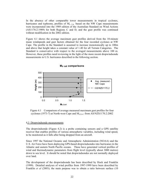
Figure 4.1 shows the average maximum gust profiles derived from the 10-minute<br />
mean windspeeds and gust factors obtained for the four recorded cyclones at NW<br />
Cape. The profile in the Standard is assumed to increase monotonically up to 100m<br />
and above that height takes a constant value of 1.40 for all Terrain Categories. The<br />
Standard is conservative with respect to the averaged measurements above 100 m.<br />
However, these profiles need reviewing in the light of the more recent dropwindsonde<br />
measurements in U.S. hurricanes described in the following section.<br />
Mz cat comparisons<br />
500<br />
Height (m)<br />
400<br />
300<br />
200<br />
100<br />
0<br />
0.0 0.5 1.0 1.5<br />
Mz,Cat1<br />
Avg. measured -<br />
NW Cape<br />
AS/NZS1170.2<br />
Figure 4.1 Comparison of average measured maximum gust profiles for four<br />
cyclones (1973-7) at North-west Cape and M z,Cat 1 from AS/NZS1170.2:2002<br />
4.3 Dropwindsonde measurements<br />
The dropwindsonde (Figure 4.2) is a probe containing sensors and a GPS satellite<br />
receiver that enables profiles of various atmospheric variables, including wind speed,<br />
to be monitored as it falls after being dropped from an aircraft.<br />
Since 1997 the National Oceanic and Atmospheric Administration (NOAA) and the<br />
U.S. Air Force have been deploying GPS-based dropwindsondes into hurricanes in the<br />
Atlantic and eastern North Pacific oceans. These have generated vertical profiles of<br />
wind and thermodynamic parameters from flight level (typically about 3000 metres)<br />
down to sea level. It should be noted that dropwindsondes are not normally deployed<br />
over land.<br />
The development of the dropwindsonde has been described by Hock and Franklin<br />
(1999). Detailed analyses of wind profiles from 1997-1999 have been described by<br />
Franklin et al (2003); the main purpose was to obtain a ratio between surface (10<br />
22