Chapter 4 Climate of Texas - Texas Water Development Board
Chapter 4 Climate of Texas - Texas Water Development Board
Chapter 4 Climate of Texas - Texas Water Development Board

Create successful ePaper yourself
Turn your PDF publications into a flip-book with our unique Google optimized e-Paper software.
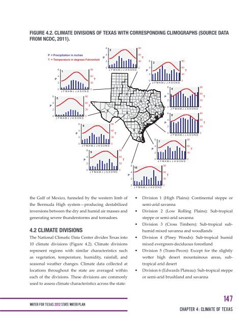
FIGURE 4.2. CLIMATE DIVISIONS OF TEXAS WITH CORRESPONDING CLIMOGRAPHS (SOURCE DATA<br />
FROM NCDC, 2011).<br />
6<br />
90<br />
2<br />
P = Precipitation in inches<br />
4<br />
60<br />
P<br />
T<br />
T = Temperature in degrees Fahrenheit<br />
2<br />
30 6<br />
90<br />
3<br />
6<br />
0<br />
0 4<br />
60<br />
90<br />
J F M A M J J A S O N D<br />
1<br />
P<br />
T<br />
4<br />
60<br />
2<br />
30<br />
P<br />
T<br />
0<br />
2<br />
30<br />
J F M A M J J A S O N D<br />
0<br />
6<br />
0<br />
0<br />
1<br />
J F M A M J J A S O N D<br />
4<br />
2<br />
4<br />
6<br />
90<br />
P<br />
5<br />
3<br />
2<br />
4<br />
60<br />
P<br />
T<br />
4 0<br />
2<br />
30<br />
J F M A M J J A S O N D<br />
5<br />
6<br />
6<br />
0<br />
0<br />
8<br />
J F M A M J J A S O N D<br />
7 8<br />
4<br />
P<br />
6<br />
90<br />
6<br />
2<br />
4<br />
60<br />
9<br />
P<br />
T<br />
0<br />
J F M A M J J A S O N D<br />
2<br />
30<br />
0<br />
10<br />
6<br />
90<br />
7<br />
0<br />
J F M A M J J A S O N D<br />
4<br />
60<br />
6<br />
4<br />
9<br />
90<br />
60<br />
P<br />
T<br />
2<br />
30<br />
P<br />
T<br />
0<br />
J F M A M J J A S O N D<br />
0<br />
2<br />
30<br />
6<br />
10<br />
90<br />
0<br />
J F M A M J J A S O N D<br />
0<br />
4<br />
60<br />
P<br />
T<br />
2<br />
30<br />
90<br />
60<br />
T<br />
30<br />
0<br />
90<br />
60<br />
T<br />
30<br />
0<br />
0<br />
J F M A M J J A S O N D<br />
0<br />
the Gulf <strong>of</strong> Mexico, funneled by the western limb <strong>of</strong><br />
the Bermuda High system—producing destabilized<br />
inversions between the dry and humid air masses and<br />
generating severe thunderstorms and tornadoes.<br />
4.2 CLIMATE DIVISIONS<br />
The National Climatic Data Center divides <strong>Texas</strong> into<br />
10 climate divisions (Figure 4.2). <strong>Climate</strong> divisions<br />
represent regions with similar characteristics such<br />
as vegetation, temperature, humidity, rainfall, and<br />
seasonal weather changes. <strong>Climate</strong> data collected at<br />
locations throughout the state are averaged within<br />
each <strong>of</strong> the divisions. These divisions are commonly<br />
used to assess climate characteristics across the state:<br />
• Division 1 (High Plains): Continental steppe or<br />
semi-arid savanna<br />
• Division 2 (Low Rolling Plains): Sub-tropical<br />
steppe or semi-arid savanna<br />
• Division 3 (Cross Timbers): Sub-tropical subhumid<br />
mixed savanna and woodlands<br />
• Division 4 (Piney Woods): Sub-tropical humid<br />
mixed evergreen-deciduous forestland<br />
• Division 5 (Trans-Pecos): Except for the slightly<br />
wetter high desert mountainous areas, subtropical<br />
arid desert<br />
• Division 6 (Edwards Plateau): Sub-tropical steppe<br />
or semi-arid brushland and savanna<br />
WAT E R FOR TEXAS 2012 STATE WATER PLAN<br />
147<br />
<strong>Chapter</strong> 4 : climate <strong>of</strong> <strong>Texas</strong>