Boulder County - Urban Drainage and Flood Control District
Boulder County - Urban Drainage and Flood Control District
Boulder County - Urban Drainage and Flood Control District

Create successful ePaper yourself
Turn your PDF publications into a flip-book with our unique Google optimized e-Paper software.
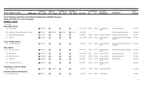
ID NO<br />
PROJECT NAME CONCEPT DESIGN CNSTRCTN ELIGIBLE<br />
STATIONING<br />
TRIBUTARY OK? DATE OK? DATE OK? DATE YES DATE SEC TS R DS US<br />
STATION<br />
REFERENCE<br />
COMMENTS<br />
LAST<br />
UPDATE<br />
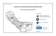
<strong>Urban</strong> <strong>Drainage</strong> <strong>and</strong> <strong>Flood</strong> <strong>Control</strong> <strong>District</strong> Maintenance Eligibility Program<br />
Status of Projects by Local Government<br />
<strong>Boulder</strong> <strong>County</strong><br />
17-Dec-2013<br />
BOULDER CREEK<br />
738<br />
ERTL Property 12/30/1983 17,18-1N-69W 665+00 738+00 Lower <strong>Boulder</strong> Cr. Leaving floodplain open.<br />
FHAD<br />
10/7/1987<br />
656<br />
Heatherwood <strong>Drainage</strong> Improvements<br />
unnamed<br />
9/18/1987 9/18/1987 9/18/1987 9/18/1987 13-1N-70W<br />
After-the-fact approval requested.<br />
9/18/1987<br />
635<br />
741<br />
Kenosha Road at <strong>Boulder</strong> Creek 7/24/1987 11-1N-69W 446+00 450+00 <strong>Boulder</strong> Creek FHAD Disagree with hydraulic analysis<br />
The Farm 7/31/1980 16,17-1N-69W 545+00 653+00 Lower <strong>Boulder</strong> Cr. Channel left alone. Mining in floodplain<br />
FHAD<br />
proposed.<br />
7/31/1987<br />
10/7/1987<br />
COAL CREEK (BOCO)<br />
636 Tanaka Brothers' Farms 7/24/1987 12-1N-69W 55+00 139+00 Coal Creek FHAD Straightened channel w/o <strong>County</strong> OK or<br />
(SCS)<br />
404 Permit.<br />
DRY CREEK<br />
286 Dry Creek Meadows 6/24/1986 19-1N-69W 93+00 117+50 <strong>Boulder</strong> Cr/Dry Cr Agricultural use proposed in floodplain...<br />
FHAD<br />
7/31/1987<br />
8/1/1986<br />
739<br />
740<br />
38<br />
1520<br />
ERTL Property 12/30/1983 17,20-1N-69W 5+00 39+00 Dry Creek FHAD Leaving floodplain open.<br />
Mallard Pond Farms 12/20/1984 36-1N-70W 267+50 287+50 Dry Creek FHAD Keeping floodplain open.<br />
White Farm 3/18/1986 30-1N-69W 151+50 153+50 <strong>Boulder</strong> Cr/Dry Cr Open floodplain...<br />
FHAD<br />
Witching Stick Golf Course 10/4/1994<br />
19-1N-69W 118+00 135+00 <strong>Boulder</strong> Cr./Dry Cr.<br />
FHAD<br />
10/7/1987<br />
10/7/1987<br />
4/24/1986<br />
10/5/1994<br />
FOURMILE CANYON CREEK<br />
204<br />
Palo Park #4 2/12/1985 2/12/1985<br />
17-1N-70W 144+00 158+00 <strong>Boulder</strong> Tribs. FHAD<br />
SIXMILE RESERVOIR DRAINA<br />
1222<br />
Buckingham Green C<br />
4/7/1992<br />
12-1N-70W 34+00 42+00 Gunbarrel OSP<br />
6/11/1986<br />
4/9/1992<br />
1
ID NO<br />
PROJECT NAME CONCEPT DESIGN CNSTRCTN ELIGIBLE<br />
STATIONING<br />
TRIBUTARY OK? DATE OK? DATE OK? DATE YES DATE SEC TS R DS US<br />
STATION<br />
REFERENCE<br />
COMMENTS<br />
LAST<br />
UPDATE<br />
SOUTH BOULDER CREEK<br />
203<br />
Marshall Pit 8/21/1985<br />
16-1S-70W 215+00 245+00 S. <strong>Boulder</strong> Creek MP<br />
6/11/1986<br />
Legend<br />
1/1/95<br />
1/1/95<br />
1/1/95<br />
1/1/95<br />
Concept, design or construction approved as of the given date.<br />
Concept, design or construction reviewed but not approved as of the given date.<br />
Concept, design, construction or final eligibility not yet considered.<br />
Project not eligible for <strong>District</strong> maintenance assistance as of the given date.<br />
Project eligible for <strong>District</strong> maintenance assistance as of the given date.<br />
2
ID NO<br />
PROJECT NAME CONCEPT DESIGN CNSTRCTN ELIGIBLE<br />
STATIONING<br />
TRIBUTARY OK? DATE OK? DATE OK? DATE YES DATE SEC TS R DS US<br />
STATION<br />
REFERENCE<br />
COMMENTS<br />
LAST<br />
UPDATE<br />
3