Hazards, Disasters And Your Community - United Nations ...
Hazards, Disasters And Your Community - United Nations ...
Hazards, Disasters And Your Community - United Nations ...

Create successful ePaper yourself
Turn your PDF publications into a flip-book with our unique Google optimized e-Paper software.
Flash floods defined as floods which occurs within six hours of the beginning of heavy rainfall, and are<br />
usually associated with cloud bursts, storms and cyclones requiring rapid localized warnings and<br />
immediate response if damage is to be mitigated. Wireless network and telephone connections are used<br />
to monitor flood conditions. In case of flash floods, warnings for timely evacuation may not always be<br />
possible.<br />
ELEMENTS AT RISK<br />
Anything in the flood plains will get inundated. Buildings built of earth, weak foundations and water<br />
soluble materials will collapse endangering humans and their property. Basements of buildings are under<br />
risk. Utilities such as sewerage, water supply, communication lines, and power are put at risk. Food stock<br />
in the godowns, agricultural fields, salt pans, livestock, vehicles, machinery and equipments mounted on<br />
the ground, fishing boats are also put at risk.<br />
INDIAN FLOODS<br />
Floods occur in almost all rivers basins of the country. Heavy rainfall, inadequate capacity of rivers to<br />
carry the high flood discharge, inadequate drainage to carry away the rainwater quickly to Streams/<br />
Rivers are the main causes of floods. Ice jams or land slides blocking streams; typhoons and cyclones<br />
also cause floods. Excessive rainfall combined with inadequate carrying capacity of streams resulting in<br />
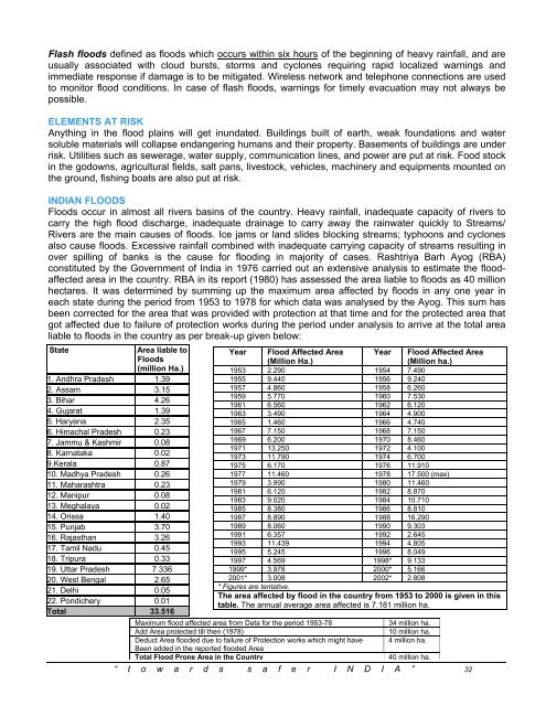
over spilling of banks is the cause for flooding in majority of cases. Rashtriya Barh Ayog (RBA)<br />
constituted by the Government of India in 1976 carried out an extensive analysis to estimate the floodaffected<br />
area in the country. RBA in its report (1980) has assessed the area liable to floods as 40 million<br />
hectares. It was determined by summing up the maximum area affected by floods in any one year in<br />
each state during the period from 1953 to 1978 for which data was analysed by the Ayog. This sum has<br />
been corrected for the area that was provided with protection at that time and for the protected area that<br />
got affected due to failure of protection works during the period under analysis to arrive at the total area<br />
liable to floods in the country as per break-up given below:<br />
State<br />
Area liable to<br />
Floods<br />
(million Ha.)<br />
1. <strong>And</strong>hra Pradesh 1.39<br />
2. Assam 3.15<br />
3. Bihar 4.26<br />
4. Gujarat 1.39<br />
5. Haryana 2.35<br />
6. Himachal Pradesh 0.23<br />
7. Jammu & Kashmir 0.08<br />
8. Karnataka 0.02<br />
9.Kerala 0.87<br />
10. Madhya Pradesh 0.26<br />
11. Maharashtra 0.23<br />
12. Manipur 0.08<br />
13. Meghalaya 0.02<br />
14. Orissa 1.40<br />
15. Punjab 3.70<br />
16. Rajasthan 3.26<br />
17. Tamil Nadu 0.45<br />
18. Tripura 0.33<br />
19. Uttar Pradesh 7.336<br />
20. West Bengal 2.65<br />
21. Delhi 0.05<br />
22. Pondichery 0.01<br />
Total 33.516<br />
Year Flood Affected Area<br />
(Million Ha.)<br />
Year Flood Affected Area<br />
(Million ha.)<br />
1953 2.290 1954 7.490<br />
1955 9.440 1956 9.240<br />
1957 4.860 1958 6.260<br />
1959 5.770 1960 7.530<br />
1961 6.560 1962 6.120<br />
1963 3.490 1964 4.900<br />
1965 1.460 1966 4.740<br />
1967 7.150 1968 7.150<br />
1969 6.200 1970 8.460<br />
1971 13.250 1972 4.100<br />
1973 11.790 1974 6.700<br />
1975 6.170 1976 11.910<br />
1977 11.460 1978 17.500 (max)<br />
1979 3.990 1980 11.460<br />
1981 6.120 1982 8.870<br />
1983 9.020 1984 10.710<br />
1985 8.380 1986 8.810<br />
1987 8.890 1988 16.290<br />
1989 8.060 1990 9.303<br />
1991 6.357 1992 2.645<br />
1993 11.439 1994 4.805<br />
1995 5.245 1996 8.049<br />
1997 4.569 1998* 9.133<br />
1999* 3.978 2000* 5.166<br />
2001* 3.008 2002* 2.808<br />
* Figures are tentative.<br />
The area affected by flood in the country from 1953 to 2000 is given in this<br />
table. The annual average area affected is 7.181 million ha.<br />
Maximum flood affected area from Data for the period 1953-78<br />
Add Area protected till then (1978)<br />
Deduct Area flooded due to failure of Protection works which might have<br />
Been added in the reported flooded Area<br />
Total Flood Prone Area in the Country<br />
34 million ha.<br />
10 million ha.<br />
4 million ha.<br />
40 million ha.<br />
“ t o w a r d s s a f e r I N D I A ” 32