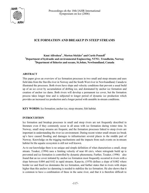
ICE FORMATION AND BREAKUP IN STEEP STREAMS - River Ice
ICE FORMATION AND BREAKUP IN STEEP STREAMS - River Ice
ICE FORMATION AND BREAKUP IN STEEP STREAMS - River Ice

You also want an ePaper? Increase the reach of your titles
YUMPU automatically turns print PDFs into web optimized ePapers that Google loves.
Proceedings oh the 18th IAHR International<br />
Symposium on <strong>Ice</strong> (2006)<br />
<strong>ICE</strong> <strong>FORMATION</strong> <strong>AND</strong> <strong>BREAKUP</strong> <strong>IN</strong> <strong>STEEP</strong> <strong>STREAMS</strong><br />
Knut Alfredsen 1 , Morten Stickler 1 and Curtis Pennell 2<br />
1 Department of hydraulic and environmental Engineering, NTNU, Trondheim, Norway<br />
2 Department of fisheries and oceans, St.Johns, Newfoundland, Canada<br />
ABSTRACT<br />
This paper gives an overview of ice formation processes in two small and steep streams and uses<br />
field data from the Stavilla river in Norway and the South West river in Newfoundland, Canada to<br />
illustrated the processes. Both rivers have slope and velocity conditions that prevent a usual build<br />
up of an ice cover by accumulation of drifting ice, and dominated by anchor ice formation and<br />
creation of anchor ice dams. Both rivers will develop a permanent ice cover, but the formation<br />
process takes longer time and is subjected to longer period of dynamic ice production which<br />
provides an increased ice production and a longer period with unstable in-stream conditions.<br />
KEY WORDS: <strong>Ice</strong> formation; anchor ice; steep streams; fish habitat.<br />
<strong>IN</strong>TROCUDTION<br />
<strong>Ice</strong> formation and breakup processes in small and steep rivers are not frequently described in<br />
literature even if they commonly occur in all areas with ice formation during winter time. In<br />
Norway, small steep streams are frequent, and the formation processes linked to steep rivers are<br />
important in understanding the river ice environment. During recent winter small stream ice break<br />
up’s have caused flooding and damages to infrastructure several places in the middle part of<br />
Norway. Knowledge on the trigging mechanisms and the impacts from such events on in-stream<br />
habitat for the aquatic ecosystem is still not well known.<br />
As to our knowledge there is no unique and simple definition of what characterizes a small, steep<br />
stream. Tesaker, (1994) uses a limiting velocity of near 60 cm/s, where retrograde build up is<br />
prevented and ice formation is controlled by dynamic phenomena. Further, Tesaker, (1996) also<br />
found that an ice cover initiated by anchor ice formation most frequently occurred in rivers with a<br />
slope between 0.004 and 0.02 in rapid streams. Kanavin, (1970) defines a slope of 0.002 where<br />
border ice and frazil ice dominates the ice formation, and further states that in rivers with slopes<br />
higher than this anchor ice damming is needed to stabilize the ice formation. He also shows that it<br />
is common to have a combination of these in the same river, and that it is therefore difficult to<br />
-117-
Proceedings oh the 18th IAHR International<br />
Symposium on <strong>Ice</strong> (2006)<br />
draw sharp boundaries between the processes. Further, Hirayama et al. (2002) found similar<br />
results in which a slope limit of 0.001 defined border ice dominated flow, but with a transition<br />
between retrograde build up and border ice down to about a slope of 0.0003.<br />
In general we would expect ice growth in a steep river in a series of processes that overcomes the<br />
velocity and slope factor that prevents the usual retrograde build up of the ice (Tesaker, 1994).<br />
These can be summarized as follows:<br />
- Border ice formation in slow flowing areas along the bank and in areas with emergent<br />
boulders.<br />
- Anchor ice formation and the accumulation of anchor ice and frazil into anchor ice dams.<br />
This usually occurs in areas with large substrate and boulders, over natural weirs in the<br />
river and in shallow or restricted areas of the stream. With prolonged cold conditions the<br />
anchor ice dams may freeze and stabilize.<br />
- Anchor ice dams create a back water effect and reduce the upstream velocity. This allows<br />
surface ice formation, and also ice cover build up by accumulation of floating ice.<br />
- With time the dams may drain leaving ice covers that span the river width or causing a<br />
cracked and refrozen cover behind the dam. The reach develops a stable ice cover<br />
- A stabilized reach may hold until mild weather and increased discharge break up the ice.<br />
In steep stream ice run caused by collapsed dams is common also in winter with just small<br />
fluctuations in temperature<br />
Over the last years a research program has been undertaken as cooperation between researchers in<br />
Canada and Norway to study winter habitat for juvenile Atlantic salmon. As a part of this, work<br />
has been undertaken to study the ice processes in several small streams and how they impact on<br />
habitat availability. This paper gives an overview of this work and shows ice dynamics of two<br />
streams with comparative hydraulic features.<br />
a)<br />
b)<br />
Figure 1 Study sites<br />
-118-
Proceedings oh the 18th IAHR International<br />
Symposium on <strong>Ice</strong> (2006)<br />
METHODS<br />
Study sites<br />
The ice formation was studied at two different sites, the <strong>River</strong> Stavilla in central Norway and<br />
South West <strong>River</strong> in Terra Nova, Newfoundland, Canada. In <strong>River</strong> Stavilla data was collected<br />
during winter of 2003/04 and 2005/06 and in South West river during the winter of 2005/06.<br />
The river Stavilla (Figure 1a) is located in central Norway south of Trondheim (62° 55’ N 10° 15’<br />
E). The catchment is 172.4 km 2 and mean discharge of 4.4 m 3 /s. The study site is located in the<br />
lower part of the river where it meets tributary Ila to form the Sokna river. The average gradient is<br />
1.6 % composed of two different sections; a steep rapid section upstream (gradient 0.024) and a<br />
gentle run downstream (average gradient 0.005). Substrate distribution had a mean size of 25 cm<br />
± 15 SD. ,in addition to several emergent boulders, particularly in the upstream section.<br />
The South West <strong>River</strong> (Figure 1b) is located in Terra Nova Park in the eastern part of<br />
Newfoundland (48 34’N 53 50’W). The catchment is 36.7 km 2 and has a mean winter discharge<br />
of 0.5 m3/s. The study area has a gradient of 0.02 and the substrate is composed of cobbles and<br />
boulders.<br />
Data collection<br />
Both sites have been mapped using a total station. Data on geometry and substrate distribution<br />
were collected during ice free conditions, and data on ice have been collected during winter field<br />
campaigns. The water level was monitored before and after the ice formed with objective to<br />
estimate the ice effects on the water level. Anchor ice was mapped both for location and thickness,<br />
particularly on locations were anchor ice dams formed. The extent of border ice was mapped<br />
during initial ice formation, and the ice cover development was mapped several times during the<br />
winter. A time lapse camera system was installed to monitor ice development and to find the<br />
timing of releases and initial growth. In Stavilla and South West <strong>River</strong> climate data was logged<br />
every hour using a weather station (Campbell Scientific) collecting data every hour.<br />
100<br />
90<br />
Waterlevel (cm)<br />
80<br />
70<br />
60<br />
50<br />
40<br />
30<br />
14.11 28.11 12.12 26.12 09.01 23.01<br />
10<br />
5<br />
Air Temperature (deg C)<br />
0<br />
-5<br />
-10<br />
-15<br />
-20<br />
-25<br />
14.11 28.11 12.12 26.12 09.01 23.01<br />
Figure 2 Temperature and waterlevel in Stavilla<br />
-119-
Proceedings oh the 18th IAHR International<br />
Symposium on <strong>Ice</strong> (2006)<br />
RESULTS<br />
Figure 2 shows air temperature and water level fluctuations for Stavilla for the winter 2005/06,<br />
and figure 3 shows the air temperature for South West <strong>River</strong>.<br />
15<br />
10<br />
Air temperature (deg C)<br />
5<br />
0<br />
-5<br />
-10<br />
-15<br />
-20<br />
02.01 09.01 16.01 23.01 30.01 06.02<br />
Figure 3 Temperature South West <strong>River</strong><br />
28-2 2-3<br />
3-3 4-3<br />
Figure 4 Growth of anchor ice dams in Stavilla<br />
In Stavilla we saw border ice formation during the first cold days in late October (2003) and early<br />
November (2005). During the first cold period in both years, five anchor ice dams was established<br />
which all except for the lower dam was drained. In addition, anchor ice formed on large boulders<br />
and on the river bottom of the lower part of the reach. The edges of the initial anchor ice dams<br />
-120-
Proceedings oh the 18th IAHR International<br />
Symposium on <strong>Ice</strong> (2006)<br />
froze over, creating a constriction in the river channel which increased the border ice cover and<br />
worked as a foundation for repeated anchor ice dam formation over the following days. We<br />
observed an initial anchor ice thickness of 58 cm in 2003 and the highest dam reached nearly 80<br />
cm after several repeated events. Eventually, the river froze over. During winter of 2003 the ice<br />
cover lasted until spring. In the winter of 2005 the ice was removed from the river at two<br />
occasions, the first on the 11 th of December and the second on the 2 nd of February (see Figure 2).<br />
This lead to three periods of ice growth in Sokna this winter each produced a complete ice layer<br />
following the same pattern as outlined above. The development of anchor ice dams over a period<br />
in early March 2005 can be seen on photos in figure 4.<br />
During freeze up ice conditions in South West <strong>River</strong> were highly dynamic causing repeated ice<br />
runs several times before it stabilized in mid February. Anchor ice formed during cold nights and<br />
during nights with snow fall. On these events, four larger anchor ice dams repeatedly established<br />
reaching up to 60 cm in height on the same locations characterized by emergent boulders. During<br />
mid-day anchor ice ceased and the dams broke and drained causing a”domino-effect” downstream.<br />
During days with air temperature above -15 C the anchor remained in the river. In the beginning<br />
of the freeze up surface ice growth occurred along the river margins and around boulders. After<br />
the establishment of the anchor ice dams, the surface ice cover further developed on ponds behind<br />
each dam.<br />
During freeze up water level fluctuated repeatedly in relation to establishment and drainage of<br />
anchor ice dam. During the freeze-up period, the water level in both reaches showed a “stair step”<br />
effect due to the damming. Figure 5 show a water level measurement for Stavilla with anchor ice<br />
dams in place, and a similar graph for South West <strong>River</strong> measured after one anchor ice event in<br />
late January. Upstream anchor dams, velocities were reduced, promoting the development of a<br />
stable ice cover. In South West <strong>River</strong> velocities and depths were measured in two sections at<br />
positions where anchor ice dams were formed. Table 1 shows the mean and maximum values<br />
measured in each section.<br />
Table 1 Measurements at anchor ice dam locations. Velocities (v) in cm/s and depths (d) in cm.<br />
With anchor ice dams<br />
Without anchor ice dams<br />
Mean v / d Max v / d Mean v / d Max v / d<br />
28 / 45 33 / 50 39 / 33 46 / 38<br />
37 / 43 53 / 48 60 / 29 76 / 30<br />
-121-
Proceedings oh the 18th IAHR International<br />
Symposium on <strong>Ice</strong> (2006)<br />
South West <strong>River</strong><br />
Stavilla<br />
1007.0<br />
99.4<br />
1006.5<br />
99.2<br />
Elevation (m)<br />
1006.0<br />
1005.5<br />
Elevation (m)<br />
99.0<br />
98.8<br />
1005.0<br />
98.6<br />
1004.5<br />
4830 4840 4850 4860 4870 4880 4890 4900 4910 4920<br />
East (m)<br />
98.4<br />
0 20 40 60<br />
Distance from lower end (m)<br />
Jan 23 - with anchor ice dams<br />
Jan 25 - ice free conditions<br />
Anchor ice dam<br />
Water level with ice<br />
Water level without ice<br />
Position of anchor ice dams<br />
Figure 5 Water levels with anchor ice dams<br />
Figure 6 shows the velocity profiles together with a control profile at a location upstream of the<br />
anchor ice areas which is not much influenced by the dams.<br />
Velocity (cm/s)<br />
80<br />
70<br />
60<br />
50<br />
40<br />
30<br />
20<br />
1.0 1.5 2.0 2.5 3.0 3.5 4.0 4.5<br />
Position from left bank (m)<br />
Velocity - with ice<br />
Velocity - no ice<br />
80<br />
70<br />
60<br />
50<br />
40<br />
30<br />
20<br />
10<br />
0<br />
1.5 2.0 2.5 3.0 3.5 4.0<br />
Position from left bank (m)<br />
80<br />
60<br />
40<br />
20<br />
0<br />
2.0 2.5 3.0 3.5 4.0 4.5 5.0 5.5<br />
Position from left bank (m)<br />
Figure 6 Velcoity distribution with and without ice<br />
As mentioned, break-up’s were observed during the study period. In Stavilla the break up during<br />
winter of 2005/06 created steep wave fronts and periods with local jamming and water level rises.<br />
At the present time no measurements on ice breakup have been carried out, but during February<br />
2006 ice breakup in Stavilla measurement equipment located 1.5 meters over normal river level<br />
was flooded due to damming caused by the ice jam that formed, so breakups are also very<br />
important for the understanding of the small river environment.<br />
-122-
Proceedings oh the 18th IAHR International<br />
Symposium on <strong>Ice</strong> (2006)<br />
DISCUSSION<br />
There are currently not many studies reported in literature on ice formation and breakup in small<br />
streams, and results from the studies done does not give clear boundaries for the processes<br />
controlling the ice formation. In general the observations in both rivers in this study follow the<br />
process of ice formation were retrograde buildup is prevents described by Tesaker (1994). The<br />
difference is mainly that South West <strong>River</strong> is more unstable due to larger temperature fluctuations<br />
than Stavilla and therefore showed more frequent anchor ice releases. The time to ice<br />
development on stabilized anchor ice dams was thereby prolonged and it took longer time to<br />
proceed beyond step 2 in Tesaker’s process description.<br />
<strong>River</strong> slope and temperature is used as a method to differentiate between retrograde and anchor ice<br />
controlled ice build up. Both study streams are well within all slope criteria’s as defined by<br />
Tesaker (1998) and Kanavin (1970). Hirayama (1986 and 2002) defined an ice formation<br />
classification based on temperature and river slope. Both study rivers fall within the type II ice<br />
formation classification, which is dominated by border ice formation. This corresponds well with<br />
the observations done at the two study sites.<br />
Velocities measurements at South West <strong>River</strong> show a reduction in velocity after the ice dam was<br />
in place, and in all cases the velocity was below the 0.6 m/s limit proposed by Tesaker as limit for<br />
ice cover formation by accumulation. But both in South West <strong>River</strong> and in Stavilla it was<br />
observed that anchor ice formation was needed to form an ice cover at sites with ice free water<br />
velocities below 0.6 m/s, and this indicates that the velocity criteria may not be directly applicable<br />
but should more be used as an average over longer river reaches.<br />
CONCLUSION<br />
<strong>Ice</strong> formation in steep rivers may significantly alter the physical conditions. During freeze up and<br />
break up the conditions may become highly variable due to dynamic ice formation. A<br />
combination of discharge and accumulated cooling controls the timing of the anchor ice formation.<br />
In this study we found that anchor ice dams were favored on locations with shallow, natural weirs<br />
and/or in areas with emergent boulder. During freezing events, the river was transformed into a<br />
succession of small pools replacing the original riffle habitat in the reach. There was no<br />
observation of flooding outside the channel margins due to the anchor ice dam formation in<br />
neither in Stavilla nor in South West river. In the South West <strong>River</strong> observations of anchor ice<br />
dam releases during the study period were mainly controlled by smaller variation in water<br />
temperature. In Sokna we saw two ice runs over the period, both related to mild weather<br />
conditions with rain and increased discharge. The ice formation in both reaches follows the same<br />
pattern regarding positions of dams and ice cover formation each time, but timing of events,<br />
duration of freeze up period and ice thickness varies with climate and discharge. More studies are<br />
needed to fully understand the growth and break up of ice in small rivers and to develop methods<br />
to predict and analyze the ice dynamics and to link this to ecosystem response.<br />
ACKNOWLEDGEMENTS<br />
The authors wish to thank all the people that participated in the field campaigns. Thanks to Jo<br />
Halvard Halleraker at S<strong>IN</strong>TEF Energy Research who provided the Sokna climate data.<br />
-123-
Proceedings oh the 18th IAHR International<br />
Symposium on <strong>Ice</strong> (2006)<br />
REFERENCES<br />
Hirayama, K. 1986. Growth of ice cover in steep and small rivers. IAHR <strong>Ice</strong> Symposium, Iowa<br />
City, pp 451 – 464.<br />
Hirayama, K., M. Yamazaki & H. T. Shen, 2002. Aspects of river ice hydrology in Japan.<br />
Hydrological processes 16: 891-904.<br />
Kanavin, E., 1970. Islegging i sjøer og elver [<strong>Ice</strong> formation in lakes and rivers] (In Norwegian).<br />
Oslo, Norwegian Water and Energy Directorate.<br />
Tesaker, E., 1994. <strong>Ice</strong> formation in steep rivers. S. Løset & E. Tesaker. 12th International<br />
Symposium on <strong>Ice</strong>, Trondheim, Norway: 630-638.<br />
Tesaker, E., 1996. Interaction between ice and water flow in rapids. Proceedings of the IAHR <strong>Ice</strong><br />
Symposium, Bejing, China.<br />
-124-