Options for Improving Climate Modeling to Assist Water Utility ...
Options for Improving Climate Modeling to Assist Water Utility ...
Options for Improving Climate Modeling to Assist Water Utility ...

You also want an ePaper? Increase the reach of your titles
YUMPU automatically turns print PDFs into web optimized ePapers that Google loves.
<strong>Water</strong> <strong>Utility</strong> <strong>Climate</strong> Alliance White Paper<br />
<strong>Options</strong> <strong>for</strong> <strong>Improving</strong> <strong>Climate</strong> <strong>Modeling</strong> <strong>to</strong> <strong>Assist</strong> <strong>Water</strong> <strong>Utility</strong> Planning <strong>for</strong> <strong>Climate</strong> Change<br />
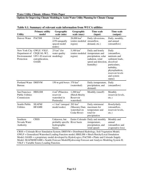
Table S.1. Summary of relevant scale in<strong>for</strong>mation from WUCA utilities<br />
<strong>Utility</strong><br />
Primary utility<br />
model<br />
Denver <strong>Water</strong> PACSM 2.6 km 2<br />
New York City<br />
Department of<br />
Environmental<br />
Protection<br />
Portland <strong>Water</strong><br />
Bureau<br />
San Francisco<br />
Public Utilities<br />
Commission<br />
Seattle Public<br />
Utilities<br />
Southern<br />
Nevada <strong>Water</strong><br />
Authority<br />
GWLF, VSLF,<br />
CEQUAL-W2,<br />
UFI 1-D reservoir<br />
eutrophication,<br />
OASIS<br />
Geographic<br />
scale (min)<br />
(470 unequally<br />
spaced model<br />
nodes)<br />
25 km 2 (<strong>for</strong><br />
water quality<br />
modeling)<br />
Geographic<br />
scale (max)<br />
26,000 km 2<br />
(entire modeled<br />
region)<br />
5,100 km 2<br />
(entire modeled<br />
region)<br />
DHSVM 150 m grid boxes 370 km 2<br />
HH/LSM<br />
SEAFM/<br />
HFAMII<br />
CRSS<br />
4 mi 2 (Pilarci<strong>to</strong>s<br />
reservoir<br />
watershed in<br />
Peninsula)<br />
< 1 km 2 (unequal<br />
model nodes)<br />
Unknown, but<br />
probably specific<br />
hydrographic<br />
basins<br />
(watershed)<br />
1,200 km 2<br />
(Hetch Hetchy<br />
Reservoir<br />
watershed)<br />
203 km 2<br />
(Masonry Dam<br />
watershed on<br />
Cedar River)<br />
Entire Colorado<br />
River basin<br />
Time scale<br />
(input)<br />
Daily (diversions,<br />
streamflow,<br />
demand, etc.)<br />
Daily and hourly Daily<br />
(temperature and<br />
precipitation, solar<br />
radiation, wind<br />
speed and direction,<br />
humidity)<br />
Daily (temperature,<br />
precipitation, and<br />
demand)<br />
Monthly (runoff)<br />
Daily minimum/<br />
maximum <strong>for</strong><br />
temperature and<br />
<strong>to</strong>tal <strong>for</strong><br />
precipitation<br />
Daily and monthly<br />
(temperature,<br />
precipitation, and<br />
wind speed)<br />
Time scale<br />
(output)<br />
Daily, monthly,<br />
and annual<br />
(streamflow)<br />
(streamflow,<br />
nutrients and<br />
sediment loads,<br />
dissolved<br />
particulates,<br />
turbidity,<br />
phy<strong>to</strong>plank<strong>to</strong>n,<br />
reservoir levels<br />
and system<br />
status)<br />
Daily<br />
(streamflow)<br />
Monthly<br />
(reservoir levels,<br />
etc.)<br />
Hourly/daily<br />
(streamflow,<br />
reservoir levels,<br />
etc.)<br />
Monthly and<br />
annual<br />
(streamflow and<br />
evaporative loss)<br />
CRSS = Colorado River Simulation System; DHSVM = Distributed Hydrology, Soil-Vegetation Model;<br />
GWLF = Generalized <strong>Water</strong>shed Loading Function model; HH/LSM = Hetch Hetchy/Local Simulation<br />
Model; OASIS = a proprietary model developed by HydroLogics; PACSM = Platte and Colorado Supply<br />
Model; SEAFM/HFAMII = Seattle Forecast Model/Hydrocomp Forecast and Analysis <strong>Modeling</strong> System II;<br />
VSLF = Variable Source Loading Function.<br />
Page S-2