Options for Improving Climate Modeling to Assist Water Utility ...
Options for Improving Climate Modeling to Assist Water Utility ...
Options for Improving Climate Modeling to Assist Water Utility ...

Create successful ePaper yourself
Turn your PDF publications into a flip-book with our unique Google optimized e-Paper software.
<strong>Water</strong> <strong>Utility</strong> <strong>Climate</strong> Alliance White Paper<br />
<strong>Options</strong> <strong>for</strong> <strong>Improving</strong> <strong>Climate</strong> <strong>Modeling</strong> <strong>to</strong> <strong>Assist</strong> <strong>Water</strong> <strong>Utility</strong> Planning <strong>for</strong> <strong>Climate</strong> Change<br />
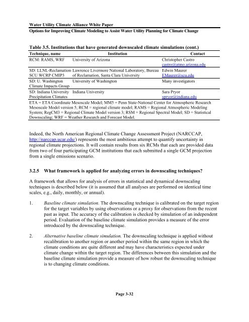
Table 3.5. Institutions that have generated downscaled climate simulations (cont.)<br />
Technique, name Institution Contact<br />
RCM: RAMS, WRF University of Arizona Chris<strong>to</strong>pher Castro<br />
castro@atmo.arizona.edu<br />
SD: LLNL-Reclamation-Lawrence Livermore National Labora<strong>to</strong>ry, Bureau Edwin Maurer<br />
SCU WCRP CMIP3 of Reclamation, Santa Clara University<br />
EMaurer@scu.edu<br />
SD: U. Washing<strong>to</strong>n University of Washing<strong>to</strong>n<br />
Many investiga<strong>to</strong>rs<br />
<strong>Climate</strong> Impacts Group<br />
SD: Indiana University<br />
Precipitation <strong>Climate</strong>s<br />
Indiana University<br />
Sara Pryor<br />
spryor@indiana.edu<br />
ETA = ETA Coordinate Mesoscale Model; MM5 = Penn State-National Center <strong>for</strong> Atmospheric Research<br />
Mesoscale Model version 5; RCM = regional climate model; RAMS = Regional Atmospheric <strong>Modeling</strong><br />
System; RegCM3 = Regional <strong>Climate</strong> Model version 3; RSM = Regional Spectral Model; SD = Statistical<br />
Downscaling; WRF = Weather Research and Forecast Model.<br />
Indeed, the North American Regional <strong>Climate</strong> Change Assessment Project (NARCCAP,<br />
http://narccap.ucar.edu/) represents the most ambitious attempt <strong>to</strong> quantify uncertainty in<br />
regional climate projections. It will contain results from six RCMs that each are provided data<br />
from two of four participating GCM institutions that each submitted a single GCM projection<br />
from a single emissions scenario.<br />
3.2.5 What framework is applied <strong>for</strong> analyzing errors in downscaling techniques?<br />
A framework that allows <strong>for</strong> analysis of errors in statistical and dynamical downscaling<br />
techniques is described below (it is assumed that all analyses are per<strong>for</strong>med on identical time<br />
scales, e.g., daily, monthly, or annual).<br />
1. Baseline climate simulation. The downscaling technique is calibrated on the target region<br />
<strong>for</strong> the target variables by using observations or a proxy <strong>for</strong> observations from the recent<br />
past as input. The accuracy of the calibration is checked by simulation of an independent<br />
period. Evaluation of the baseline climate simulation provides a measure of the error<br />
introduced by the downscaling technique.<br />
2. Alternative baseline climate simulation. The downscaling technique is applied without<br />
recalibration <strong>to</strong> another region or another period within the same region in which the<br />
climate conditions are quite different and may have characteristics expected under<br />
climate change within the target region. The differences between this simulation and the<br />
baseline climate simulation provide a measure of how robust the downscaling technique<br />
is <strong>to</strong> changing climate conditions.<br />
Page 3-32