CD and DVD data packages - NSW Department of Primary ...
CD and DVD data packages - NSW Department of Primary ...
CD and DVD data packages - NSW Department of Primary ...

Create successful ePaper yourself
Turn your PDF publications into a flip-book with our unique Google optimized e-Paper software.
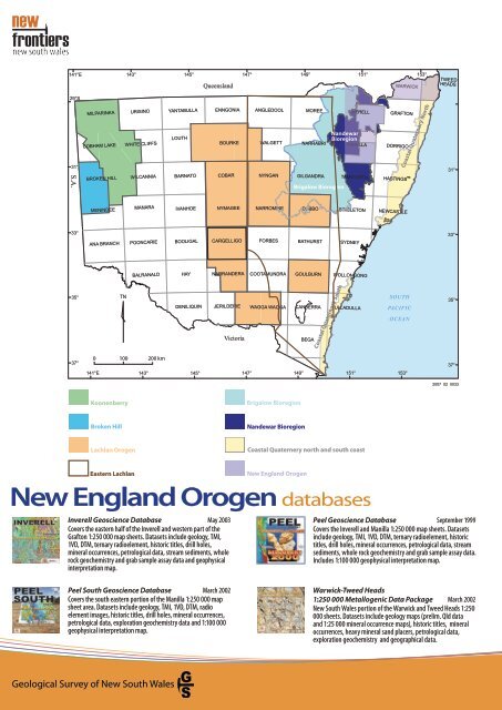
141°E<br />
29°S<br />
31°<br />
S.A.<br />
33°<br />
35°<br />
37°<br />
MILPARINKA<br />
COBHAM LAKE<br />
BROKEN HILL<br />
MENINDEE<br />
ANA BRANCH<br />
0<br />
141°E<br />
Koonenberry<br />
Broken Hill<br />
TN<br />
100<br />
143°<br />
Lachlan Orogen<br />
Eastern Lachlan<br />
URISINO<br />
WHITE CLIFFS<br />
WILCANNIA<br />
MANARA<br />
POONCARIE<br />
BALRANALD<br />
143°<br />
200 km<br />
145°<br />
YANTABULLA<br />
LOUTH<br />
BARNATO<br />
IVANHOE<br />
BOOLIGAL<br />
HAY<br />
DENILIQUIN<br />
145°<br />
Queensl<strong>and</strong><br />
ENNGONIA<br />
BOURKE<br />
COBAR<br />
NYMAGEE<br />
CARGELLIGO<br />
NARRANDERA<br />
JERILDERIE<br />
Victoria<br />
147°<br />
147°<br />
ANGLEDOOL<br />
WALGETT<br />
NYNGAN<br />
NARROMINE<br />
FORBES<br />
COOTAMUNDRA<br />
WAGGA WAGGA<br />
149°<br />
Brigalow Bioregion<br />
N<strong>and</strong>ewar Bioregion<br />
149°<br />
MOREE<br />
NARRABRI<br />
GILGANDRA<br />
Brigalow Bioregion<br />
DUBBO<br />
BATHURST<br />
GOULBURN<br />
CANBERRA<br />
BEGA<br />
Coastal Quaternary South<br />
SYDNEY<br />
ULLADULLA<br />
151°<br />
151°<br />
INVERELL<br />
N<strong>and</strong>ewar<br />
Bioregion<br />
MANILLA<br />
WOLLONGONG<br />
DORRIGO<br />
TAMWORTH HASTINGS<br />
SINGLETON<br />
Coastal Quaternery north <strong>and</strong> south coast<br />
New Engl<strong>and</strong> Orogen<br />
New Engl<strong>and</strong> Orogen <strong>data</strong>bases<br />
Inverell Geoscience Database May 2003<br />
Covers the eastern half <strong>of</strong> the Inverell <strong>and</strong> western part <strong>of</strong> the<br />
Grafton 1:250 000 map sheets. Datasets include geology, TMI,<br />
1VD, DTM, ternary radioelement, historic titles, drill holes,<br />
mineral occurrences, petrological <strong>data</strong>, stream sediments, whole<br />
rock geochemistry <strong>and</strong> grab sample assay <strong>data</strong> <strong>and</strong> geophysical<br />
interpretation map.<br />
Peel South Geoscience Database March 2002<br />
Covers the south eastern portion <strong>of</strong> the Manilla 1:250 000 map<br />
sheet area. Datasets include geology, TMI, 1VD, DTM, radio<br />
element images, historic titles, drill holes, mineral occurrences,<br />
petrological <strong>data</strong>, exploration geochemistry <strong>data</strong> <strong>and</strong> 1:100 000<br />
geophysical interpretation map.<br />
Geological Survey <strong>of</strong> New South Wales<br />
WARWICK<br />
GRAFTON<br />
NEWCASTLE<br />
SOUTH<br />
PACIFIC<br />
OCEAN<br />
153°<br />
153°<br />
Coastal Quaternary North<br />
TWEED<br />
HEADS<br />
31°<br />
33°<br />
35°<br />
37°<br />
2007_02_0033<br />
Peel Geoscience Database September 1999<br />
Covers the Inverell <strong>and</strong> Manilla 1:250 000 map sheets. Datasets<br />
include geology, TMI, 1VD, DTM, ternary radioelement, historic<br />
titles, drill holes, mineral occurrences, petrological <strong>data</strong>, stream<br />
sediments, whole rock geochemistry <strong>and</strong> grab sample assay <strong>data</strong>.<br />
Includes 1:100 000 geophysical interpretation map.<br />
Warwick-Tweed Heads<br />
1:250 000 Metallogenic Data Package March 2002<br />
New South Wales portion <strong>of</strong> the Warwick <strong>and</strong> Tweed Heads 1:250<br />
000 sheets. Datasets include geology maps (prelim. Qld <strong>data</strong><br />
<strong>and</strong> 1:25 000 mineral occurrence maps), historic titles, mineral<br />
occurrences, heavy mineral s<strong>and</strong> placers, petrological <strong>data</strong>,<br />
exploration geochemistry <strong>and</strong> geographical <strong>data</strong>.