Bilston Corridor - Wolverhampton City Council - Home Page
Bilston Corridor - Wolverhampton City Council - Home Page
Bilston Corridor - Wolverhampton City Council - Home Page

You also want an ePaper? Increase the reach of your titles
YUMPU automatically turns print PDFs into web optimized ePapers that Google loves.
Part Two – The Key Directions of Change<br />
Aim 19 – Meeting Shopping<br />
and Service Needs outside<br />
<strong>Bilston</strong> Town Centre<br />
The northern part of the <strong>Bilston</strong> <strong>Corridor</strong><br />
benefits from proximity to <strong>Wolverhampton</strong><br />
<strong>City</strong> Centre and St Johns Retail Park. Although<br />
there are no other centres in the south-east of<br />
<strong>Wolverhampton</strong>, Map 7 shows that all of the<br />
Areas of Search for Housing and Employment<br />
Land have good sustainable transport access<br />
to a centre or supermarket. There are also<br />
small parades of local shops, such as at<br />
New St, Ettingshall and along <strong>Bilston</strong> Road.<br />
However, there may still be opportunities to<br />
improve existing local shopping areas and<br />
create local shops to better meet existing<br />
and future local needs.<br />
29) Are there any suitable locations<br />
other than <strong>Bilston</strong> Town Centre that<br />
could be developed for meeting<br />
future shopping / service needs?<br />
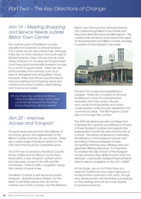
Aim 20 – Improve<br />
Access and Transport<br />
Transport issues are pivotal to the delivery of<br />
economic growth and regeneration in the<br />
<strong>Bilston</strong> <strong>Corridor</strong> and the <strong>City</strong> as a whole. There<br />
are a wide range of transport options in the<br />
AAP area that should be capitalised upon.<br />
The AAP Area is served by the Black Country<br />
Route (A463) and the Black Country New<br />
Road (A41), a key transport corridor which<br />
provides easy access to the M5 and M6<br />
motorways. There is traffic congestion along<br />
this corridor at peak times.<br />
The <strong>Bilston</strong> <strong>Corridor</strong> is well served by public<br />
transport. <strong>Wolverhampton</strong> Station, on the<br />
West Coast Main railway line, lies at the<br />
northern end of the <strong>Corridor</strong>, and the Midland<br />
Metro Line One runs from <strong>Wolverhampton</strong><br />
<strong>City</strong> Centre through <strong>Bilston</strong> Town Centre and<br />
beyond to West Bromwich and Birmingham. The<br />
corridor is also served by a bus network focussed<br />
on <strong>Wolverhampton</strong> and <strong>Bilston</strong> Centres, including<br />
a number of more frequent core routes.<br />
Provision for cyclists and pedestrians is<br />
variable. There are a number of off-road<br />
facilities but a lack of comprehensive<br />
networks, with main roads, railways<br />
and canals forming barriers and a lack<br />
of permeable routes through residential and<br />
commercial areas. The Birmingham Canal<br />
also runs through the corridor.<br />
The AAP will need to provide a strategy that<br />
maximises the capacity and efficiency of each<br />
of these transport corridors and supports the<br />
regeneration of both the area and the <strong>City</strong> as<br />
a whole. This will be achieved by maximising<br />
the efficiency of the transport network and<br />
providing a balance between modes,<br />
recognising that they play differing roles and<br />
generate differing demands. It is important<br />
to consider the role of each of the transport<br />
modes and how they relate to each other, for<br />
example, could public transport improvements<br />
help to relieve congestion on the A41 / A463?<br />
At this stage, we do not think there is a<br />
need for additional new major highways or<br />
transportation schemes in the area, though<br />
new development will inevitably put pressure<br />
on the existing network and may require<br />
local improvements.<br />
38 <strong>Bilston</strong> <strong>Corridor</strong> Area Action Plan - Issues Paper