Williams Gateway Freeway Preferred Alignment Report Final
Williams Gateway Freeway Preferred Alignment Report Final
Williams Gateway Freeway Preferred Alignment Report Final

Create successful ePaper yourself
Turn your PDF publications into a flip-book with our unique Google optimized e-Paper software.
<strong>Williams</strong> <strong>Gateway</strong> <strong>Freeway</strong> <strong>Alignment</strong><br />
<strong>Preferred</strong> <strong>Alignment</strong> Summary <strong>Report</strong><br />
and Environmental Overview Study March 2006<br />
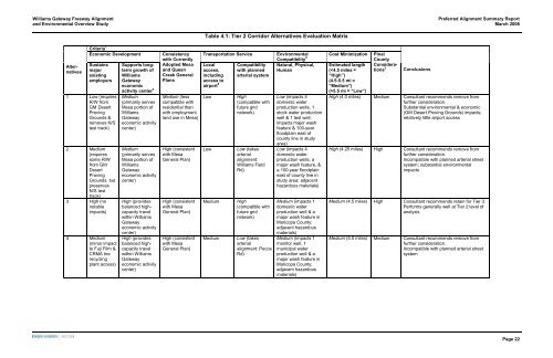
Table 4.1: Tier 2 Corridor Alternatives Evaluation Matrix<br />
Alternatives<br />
Criteria 1<br />
Economic Development Consistency<br />
with Currently<br />
Transportation Service Environmental<br />
Compatibility 2<br />
Sustains Supports longterm<br />
Adopted Mesa Local Compatibility Natural, Physical,<br />
major<br />
growth of and Queen access, with planned Human<br />
existing <strong>Williams</strong> Creek General including arterial system<br />
employers <strong>Gateway</strong> Plans<br />
access to<br />
economic<br />
airport 5<br />
activity center 4<br />
1 Low (requires<br />
R/W from<br />
GM Desert<br />
Proving<br />
Grounds &<br />
removes N/S<br />
test track)<br />
2 Medium<br />
(requires<br />
some R/W<br />
from GM<br />
Desert<br />
Proving<br />
Grounds, but<br />
preserves<br />
N/S test<br />
track)<br />
3 High (no<br />
notable<br />
impacts)<br />
4 Medium<br />
(minor impact<br />
to Fuji Film &<br />
CRMA tire<br />
recycling<br />
plant access)<br />
Medium<br />
(primarily serves<br />
Mesa portion of<br />
<strong>Williams</strong><br />
<strong>Gateway</strong><br />
economic activity<br />
center)<br />
Medium<br />
(primarily serves<br />
Mesa portion of<br />
<strong>Williams</strong><br />
<strong>Gateway</strong><br />
economic activity<br />
center)<br />
High (provides<br />
balanced highcapacity<br />
travel<br />
within <strong>Williams</strong><br />
<strong>Gateway</strong><br />
economic activity<br />
center)<br />
High (provides<br />
balanced highcapacity<br />
travel<br />
within <strong>Williams</strong><br />
<strong>Gateway</strong><br />
economic activity<br />
center)<br />
Medium (less<br />
compatible with<br />
residential than<br />
with employment<br />
land use in Mesa)<br />
High (consistent<br />
with Mesa<br />
General Plan)<br />
High (consistent<br />
with Mesa<br />
General Plan)<br />
High (consistent<br />
with Mesa<br />
General Plan)<br />
Low<br />
Low<br />
Medium<br />
Medium<br />
High<br />
(compatible with<br />
future grid<br />
network)<br />
Low (takes<br />
arterial<br />
alignment:<br />
<strong>Williams</strong> Field<br />
Rd)<br />
High<br />
(compatible with<br />
future grid<br />
network)<br />
Low (takes<br />
arterial<br />
alignment: Pecos<br />
Rd)<br />
Low (impacts 4<br />
domestic water<br />
production wells, 1<br />
stock water production<br />
well & 1 test well;<br />
impacts major wash<br />
feature & 100-year<br />
floodplain east of<br />
county line in study<br />
area)<br />
Low (impacts 4<br />
domestic water<br />
production wells, a<br />
major wash feature, &<br />
a 100-year floodplain<br />
east of county line in<br />
study area; adjacent<br />
hazardous materials)<br />
Medium (impacts 1<br />
domestic water<br />
production well & a<br />
major wash feature in<br />
Maricopa County;<br />
adjacent hazardous<br />
materials)<br />
Medium (impacts 1<br />
monitor well, 1<br />
municipal water<br />
production well & a<br />
major wash feature in<br />
Maricopa County;<br />
adjacent hazardous<br />
materials)<br />
Cost Minimization<br />
Estimated length<br />
(5.5 mi = “Low”)<br />
Pinal<br />
County<br />
Considerations<br />
3<br />
Conclusions<br />
High (4.0 miles) Medium Consultant recommends remove from<br />
further consideration.<br />
Substantial environmental & economic<br />
(GM Desert Proving Grounds) impacts;<br />
relatively little airport access<br />
High (4.25 miles) High Consultant recommends remove from<br />
further consideration.<br />
Incompatible with planned arterial street<br />
system; substantial environmental<br />
impacts<br />
Medium (4.5 miles) High Consultant recommends retain for Tier 3.<br />
Performs generally well at Tier 2 level of<br />
analysis<br />
Medium (5.0 miles) Medium Consultant recommends remove from<br />
further consideration.<br />
Incompatible with planned arterial street<br />
system<br />
Page 22