Alberta Grizzly Bear Recovery Plan 2008-2013 - Alberta Sustainable ...
Alberta Grizzly Bear Recovery Plan 2008-2013 - Alberta Sustainable ...
Alberta Grizzly Bear Recovery Plan 2008-2013 - Alberta Sustainable ...

You also want an ePaper? Increase the reach of your titles
YUMPU automatically turns print PDFs into web optimized ePapers that Google loves.
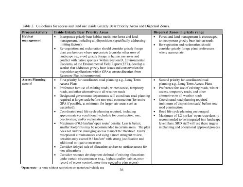
Table 2. Guidelines for access and land use inside <strong>Grizzly</strong> <strong>Bear</strong> Priority Areas and Dispersal Zones.<br />
Process/Activity Inside <strong>Grizzly</strong> <strong>Bear</strong> Priority Areas Dispersal Zones in grizzly range<br />
Habitat<br />
management<br />
Access <strong>Plan</strong>ning<br />
general<br />
• Incorporate grizzly bear habitat needs into forest and land<br />
management, including all dispositions (specifically addressing<br />
limiting factors).<br />
• Re-vegetation and reclamation should consider grizzly forage<br />
plant preferences where appropriate (consider other uses of<br />
landscape i.e., avoid grizzly forage in human use areas and<br />
conflict with native species). Within Section D, Environmental<br />
Concerns, of the Environmental Field Report (EFR), develop a<br />
section that addresses grizzly bear issues and conservation for<br />
disposition applications within GPAs; ensure direction from<br />
<strong>Recovery</strong> <strong>Plan</strong> is incorporated.<br />
• First priority for coordinated road planning e.g., Long Term<br />
Access <strong>Plan</strong>s<br />
• Preference for: use of existing roads, winter access, temporary<br />
roads, and other alternatives to all weather roads<br />
• Designated government departments will coordinate road planning<br />
required at larger scale before new road construction (for entire<br />
GPA if possible, at minimum for larger sub-areas such as<br />
watershed).<br />
• Coordinated road life cycle planning required, including<br />
approximate (or conditional) schedule for construction, use,<br />
deactivation, and/or reclamation<br />
• Maximum of 0.6 km/km 2 open route 1 density. Less is better;<br />
smaller footprints may be recommended in certain areas. The plan<br />
does not endorse managing access to meet the threshold. Under<br />
exceptional circumstances and using a more stringent review,<br />
densities may exceed 0.6 km/km 2 with strong justification and<br />
additional mitigative measures<br />
• Consider delayed sale of allocations and/or no surface access for<br />
new allocations<br />
• Consider resource development deferral of existing allocations<br />
under certain circumstances (e.g., highest quality habitat, poor<br />
record of access control, more time needed to plan access)<br />
1 Open route – a route without restrictions on motorized vehicle use<br />
36<br />
• Forest and land management is encouraged<br />
to incorporate grizzly bear habitat needs<br />
• Re-vegetation and reclamation should<br />
consider grizzly forage plant preferences<br />
where appropriate.<br />
• Second priority for coordinated road<br />
planning e.g., Long Term Access <strong>Plan</strong>s<br />
• Preference for: use of existing roads, winter<br />
access, temporary roads, and other<br />
alternatives to all weather roads<br />
• Coordinated road planning required<br />
(minimum of disposition scale) before new<br />
road construction<br />
• Road life cycle planning encouraged.<br />
• Maximum of 1.2 km/km 2 open route density<br />
recommended to be integrated into landscape<br />
level plans. SRD staff will use these targets<br />
in planning and operational approval process.