Product User Manual - CM SAF
Product User Manual - CM SAF
Product User Manual - CM SAF

You also want an ePaper? Increase the reach of your titles
YUMPU automatically turns print PDFs into web optimized ePapers that Google loves.
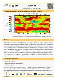
EUMETSAT Satellite Application Facility on Climate Monitoring<br />
<strong>CM</strong> <strong>SAF</strong> Cloud, Albedo, Radiation dataset,<br />
AVHRR-based, Edition 1 (CLARA-A1)<br />
Surface Albedo<br />
<strong>Product</strong> <strong>User</strong> <strong>Manual</strong><br />
DOI: 10.5676/EUM_<strong>SAF</strong>_<strong>CM</strong>/CLARA_AVHRR/V001<br />
Broadband Surface Albedo<br />
<strong>CM</strong>-60<br />
Reference Number:<br />
<strong>SAF</strong>/<strong>CM</strong>/FMI/PUM/GAC/SAL<br />
Issue/Revision Index: 1.2<br />
Date: 11 June 2012
EUMETSAT <strong>SAF</strong> on CLIMATE<br />
MONITORING<br />
<strong>Product</strong> <strong>User</strong> <strong>Manual</strong><br />
Surface Albedo CLARA-A1<br />
Doc. No.: <strong>SAF</strong>/<strong>CM</strong>/FMI/PUM/GAC/SAL<br />
Issue: 1.2<br />
Date: 11 June 2012<br />
Document Signature Table<br />
Name Function Signature Date<br />
Author Aku Riihelä<br />
Project Scientists 11/06/2012<br />
Terhikki Manninen<br />
Vesa Laine<br />
Editor Rainer Hollmann Science Coordinator 11/06/2012<br />
Approval Steering Group 26/09/2012<br />
Release Martin Werscheck Project Manager 30/11/2012<br />
Distribution List<br />
Internal Distribution<br />
Name<br />
No. Copies<br />
DWD Archive 1<br />
<strong>CM</strong> <strong>SAF</strong> Team 1<br />
External Distribution<br />
Company Name No. Copies<br />
Public 1<br />
Document Change Record<br />
Issue/ Date DCN No. Changed Pages/Paragraphs<br />
Revision<br />
1.0 11/06/2012 <strong>SAF</strong>/<strong>CM</strong>/FMI/PUM/GAC/SAL First official version presented to<br />
DRI5 review board<br />
1.1 25/05/2012 <strong>SAF</strong>/<strong>CM</strong>/FMI/PUM/GAC/SAL Implementation of RID from review<br />
board<br />
1.2 11/06/2012 <strong>SAF</strong>/<strong>CM</strong>/FMI/PUM/GAC/SAL Fixed bugs and implementation of<br />
last changes from DRI5 close-out<br />
- editorial update of cover page to<br />
account for DOI number and edition<br />
name<br />
- editorial update of the introduction<br />
section of <strong>CM</strong> <strong>SAF</strong><br />
- update of section on "Data<br />
ordering via the Web <strong>User</strong> Interface<br />
(WUI)" including now a dedicated<br />
section on copyrights<br />
2
EUMETSAT <strong>SAF</strong> on CLIMATE<br />
MONITORING<br />
<strong>Product</strong> <strong>User</strong> <strong>Manual</strong><br />
Surface Albedo CLARA-A1<br />
Doc. No.: <strong>SAF</strong>/<strong>CM</strong>/FMI/PUM/GAC/SAL<br />
Issue: 1.2<br />
Date: 11 June 2012<br />
Applicable Documents<br />
Reference Title Code<br />
AD.1. <strong>CM</strong> <strong>SAF</strong> Service Specification Document <strong>SAF</strong>/<strong>CM</strong>/DWD/SeSp/1.9<br />
AD.2.<br />
Validation Report<br />
Surface Albedo<br />
CLARA-A1<br />
<strong>SAF</strong>/<strong>CM</strong>/FMI/VAL/GAC/SAL/1.2<br />
AD.3. <strong>CM</strong> <strong>SAF</strong> <strong>Product</strong> Requirements Document <strong>SAF</strong>/<strong>CM</strong>/DWD/PRD/1.7<br />
AD.4.<br />
SYSTEMATIC OBSERVATION<br />
REQUIREMENTS FOR SATELLITE-BASED<br />
DATA PRODUCTS FOR CLIMATE - 2011<br />
Update<br />
GCOS-154<br />
Reference Documents<br />
Reference Title Code<br />
RD.1.<br />
Algorithm Theoretical Basis Document<br />
Surface Albedo<br />
CLARA-A1<br />
<strong>SAF</strong>/<strong>CM</strong>/FMI/ATBD/GAC/SAL/1.2<br />
3
EUMETSAT <strong>SAF</strong> on CLIMATE<br />
MONITORING<br />
<strong>Product</strong> <strong>User</strong> <strong>Manual</strong><br />
Surface Albedo CLARA-A1<br />
Doc. No.: <strong>SAF</strong>/<strong>CM</strong>/FMI/PUM/GAC/SAL<br />
Issue: 1.2<br />
Date: 11 June 2012<br />
Table of Contents<br />
1 THE EUMETSAT <strong>SAF</strong> ON CLIMATE MONITORING (<strong>CM</strong> <strong>SAF</strong>) .................................... 6<br />
2 INTRODUCTION ............................................................................................................ 8<br />
2.1 Suggested usage and limitations................................................................................................. 8<br />
2.2 The EUMETSAT <strong>SAF</strong> on Climate Monitoring (<strong>CM</strong> <strong>SAF</strong>) ............................................................ 8<br />
3 GLOBAL AREA COVERAGE SURFACE ALBEDO (CLARA-SAL) .............................10<br />
3.1 <strong>Product</strong> Definition ...................................................................................................................... 10<br />
3.2 <strong>Product</strong>s and availability ............................................................................................................ 10<br />
3.3 CLARA-SAL algorithm ............................................................................................................... 11<br />
3.3.1 CLARA-SAL topography correction:..................................................................................................... 12<br />
3.4 Validation ................................................................................................................................... 13<br />
3.5 Limitations .................................................................................................................................. 15<br />
3.6 Outlook ...................................................................................................................................... 16<br />
4 DATA DESCRIPTION ...................................................................................................17<br />
4.1 Data file contents ....................................................................................................................... 17<br />
5 DATA ORDERING VIA THE WEB USER INTERFACE (WUI)......................................20<br />
5.1 <strong>Product</strong> ordering process .......................................................................................................... 20<br />
5.2 Contact <strong>User</strong> Help Desk staff .................................................................................................... 20<br />
5.3 <strong>User</strong> Problem Report ................................................................................................................. 20<br />
5.4 Service Messages / log of changes ........................................................................................... 20<br />
6 FEEDBACK ..................................................................................................................21<br />
6.1 <strong>User</strong> feedback............................................................................................................................ 21<br />
6.2 Specific requirements for future products .................................................................................. 21<br />
6.3 <strong>User</strong> Workshops ........................................................................................................................ 21<br />
7 COPYRIGHT AND DISCLAIMER .................................................................................22<br />
7.1 Copyright ................................................................................................................................... 22<br />
7.2 Acknowledgement and Identification ......................................................................................... 22<br />
4
EUMETSAT <strong>SAF</strong> on CLIMATE<br />
MONITORING<br />
<strong>Product</strong> <strong>User</strong> <strong>Manual</strong><br />
Surface Albedo CLARA-A1<br />
Doc. No.: <strong>SAF</strong>/<strong>CM</strong>/FMI/PUM/GAC/SAL<br />
Issue: 1.2<br />
Date: 11 June 2012<br />
7.3 Re-distribution of <strong>CM</strong> <strong>SAF</strong> data ................................................................................................. 22<br />
8 REFERENCES ..............................................................................................................23<br />
9 ABBREVIATIONS .........................................................................................................24<br />
List of Figures<br />
Figure 1: CLARA-SAL monthly mean lat/long grid example and parameters. ...................................... 10<br />
Figure 2: The process flow of the CLARA-SAL product computation. .................................................. 11<br />
Figure 3: CLARA-SAL relative retrieval error over SGP. Red circles indicate retrieval errors at<br />
instantaneous level; the black and blue lines indicate the retrieval error of the monthly and pentad<br />
means. Red dashed line shows 25% and the blue dashed line 10% relative error levels. ............ 14<br />
Figure 4: CLARA-SAL relative retrieval error over Summit station. Red circles indicate retrieval errors<br />
at instantaneous level; the black and blue lines indicate the retrieval error of the monthly and<br />
pentad mean. Red dashed line shows 25% and the blue dashed line 10% relative error levels. . 15<br />
List of Tables<br />
Table 1: CLARA-SAL variables in a NetCDF file................................................................................... 17<br />
Table 2: CLARA-SAL product attributes ................................................................................................ 18<br />
Table 3: Attributes assigned to variables .............................................................................................. 19<br />
5
EUMETSAT <strong>SAF</strong> on CLIMATE<br />
MONITORING<br />
<strong>Product</strong> <strong>User</strong> <strong>Manual</strong><br />
Surface Albedo CLARA-A1<br />
Doc. No.: <strong>SAF</strong>/<strong>CM</strong>/FMI/PUM/GAC/SAL<br />
Issue: 1.2<br />
Date: 11 June 2012<br />
1 The EUMETSAT <strong>SAF</strong> on Climate Monitoring (<strong>CM</strong> <strong>SAF</strong>)<br />
The importance of climate monitoring with satellites was recognized in 2000 by EUMETSAT<br />
Member States when they amended the EUMETSAT Convention to affirm that the<br />
EUMETSAT mandate is also to “contribute to the operational monitoring of the climate and<br />
the detection of global climatic changes". Following this, EUMETSAT established within its<br />
Satellite Application Facility (<strong>SAF</strong>) network a dedicated centre, the <strong>SAF</strong> on Climate<br />
Monitoring (<strong>CM</strong> <strong>SAF</strong>, http://www.cmsaf.eu).<br />
The consortium of <strong>CM</strong> <strong>SAF</strong> currently comprises the Deutscher Wetterdienst (DWD) as host<br />
institute, and the partners from the Royal Meteorological Institute of Belgium (RMIB), the<br />
Finnish Meteorological Institute (FMI), the Royal Meteorological Institute of the Netherlands<br />
(KNMI), the Swedish Meteorological and Hydrological Institute (SMHI), the Meteorological<br />
Service of Switzerland (MeteoSwiss), and the Meteorological Service of the United Kingdom<br />
(UK MetOffice). Since the beginning in 1999, the EUMETSAT Satellite Application Facility on<br />
Climate Monitoring (<strong>CM</strong> <strong>SAF</strong>) has developed and will continue to develop capabilities for a<br />
sustained generation and provision of Climate Data Records (CDR’s) derived from<br />
operational meteorological satellites.<br />
In particular the generation of long-term data sets is pursued. The ultimate aim is to make the<br />
resulting data sets suitable for the analysis of climate variability and potentially the detection<br />
of climate trends. <strong>CM</strong> <strong>SAF</strong> works in close collaboration with the EUMETSAT Central Facility<br />
and liaises with other satellite operators to advance the availability, quality and usability of<br />
Fundamental Climate Data Records (FCDRs) as defined by the Global Climate Observing<br />
System (GCOS). As a major task the <strong>CM</strong>-<strong>SAF</strong> utilizes FCDRs to produce records of<br />
Essential Climate Variables (ECVs) as defined by GCOS. Thematically, the focus of <strong>CM</strong> <strong>SAF</strong><br />
is on ECVs associated with the global energy and water cycle.<br />
Another essential task of <strong>CM</strong> <strong>SAF</strong> is to produce data sets that can serve applications related<br />
to the new Global Framework of Climate Services initiated by the WMO World Climate<br />
Conference-3 in 2009. <strong>CM</strong> <strong>SAF</strong> is supporting climate services at national meteorological and<br />
hydrological services (NMHSs) with long-term data records but also with data sets produced<br />
close to real time that can be used to prepare monthly/annual updates of the state of the<br />
climate. Both types of products together allow for a consistent description of mean values,<br />
anomalies, variability and potential trends for the chosen ECVs. <strong>CM</strong> <strong>SAF</strong> ECV data sets also<br />
serve the improvement of climate models both at global and regional scale.<br />
As an essential partner in the related international frameworks, in particular WMO SCOPE-<br />
<strong>CM</strong> (Sustained COordinated Processing of Environmental satellite data for Climate<br />
Monitoring), the <strong>CM</strong> <strong>SAF</strong> - together with the EUMETSAT Central Facility, assumes the role<br />
as main implementer of EUMETSAT’s commitments in support to global climate monitoring.<br />
This is achieved through:<br />
• Application of highest standards and guidelines as lined out by GCOS for the satellite<br />
data processing,<br />
• Processing of satellite data within a true international collaboration benefiting from<br />
developments at international level and pollinating the partnership with own ideas and<br />
standards,<br />
• Intensive validation and improvement of the <strong>CM</strong> <strong>SAF</strong> climate data records,<br />
• Taking a major role in data set assessments performed by research organisations<br />
such as WCRP. This role provides the <strong>CM</strong> <strong>SAF</strong> with deep contacts to research<br />
organizations that form a substantial user group for the <strong>CM</strong> <strong>SAF</strong> CDRs,<br />
• Maintaining and providing an operational and sustained infrastructure that can serve<br />
the community within the transition of mature CDR products from the research<br />
community into operational environments.<br />
6
EUMETSAT <strong>SAF</strong> on CLIMATE<br />
MONITORING<br />
<strong>Product</strong> <strong>User</strong> <strong>Manual</strong><br />
Surface Albedo CLARA-A1<br />
Doc. No.: <strong>SAF</strong>/<strong>CM</strong>/FMI/PUM/GAC/SAL<br />
Issue: 1.2<br />
Date: 11 June 2012<br />
A catalogue of all available <strong>CM</strong> <strong>SAF</strong> products is accessible via the <strong>CM</strong> <strong>SAF</strong> webpage,<br />
www.cmsaf.eu/. Here, detailed information about product ordering, add-on tools, sample<br />
programs and documentation is provided.<br />
7
EUMETSAT <strong>SAF</strong> on CLIMATE<br />
MONITORING<br />
<strong>Product</strong> <strong>User</strong> <strong>Manual</strong><br />
Surface Albedo CLARA-A1<br />
Doc. No.: <strong>SAF</strong>/<strong>CM</strong>/FMI/PUM/GAC/SAL<br />
Issue: 1.2<br />
Date: 11 June 2012<br />
2 Introduction<br />
The purpose of this document is to provide interested users with information on the features,<br />
quality and usage of the Global Area Coverage Surface Broadband Albedo (CLARA-SAL)<br />
dataset of the Climate-<strong>SAF</strong> project. The first part of the document introduces the product and<br />
its significance. The second part discusses the features and quality of the product in more<br />
detail, and the third part describes the end user product format.<br />
Surface albedo is one of the factors governing the Earth’s radiation budget, which in turn<br />
drives the climate of our planet. (Shortwave) Surface albedo is the dimensionless ratio of the<br />
reflected (solar) radiation flux to the incoming (solar) radiation flux. It has been designated as<br />
one of the Essential Climate Variables (ECV) of the GCOS, as required by IPCC and<br />
UNFCCC (GCOS Secretariat, 2006). Because of surface albedo’s significance to the<br />
radiation budget, its continuous monitoring is of importance in understanding climate change.<br />
Satellites provide the most cost-effective means to achieve global coverage with a relatively<br />
short repeat period. All products have been developed and evaluated with respect to<br />
requirement goals defined in [AD.3]. The finally achieved product accuracies are described in<br />
[AD.2]. Of specific interest here are requirements in [AD.4] as outlined by the Global Climate<br />
Observing System (GCOS) community and issued by the United Nations World<br />
Meteorological Organisation (WMO) in 2012.<br />
The CLARA-SAL dataset spans the period from 1982-2009. The albedo products, distributed<br />
as pentad and monthly means at 0.25 degree resolution, are composed from overpass data<br />
from the Advanced Very High Resolution Radiometer (AVHRR) instruments on board the<br />
National Oceanic and Atmospheric Administration (NOAA) satellites. The characteristics of<br />
the time series and its usage are described in the following chapters. The purpose of this<br />
document is not to be a detailed guide to the workings of the algorithm itself. Although<br />
processing flow is described, readers interested in the nuts and bolts of the SAL algorithm<br />
are encouraged to read the CLARA-SAL Algorithm Theoretical Baseline Document (ATBD)<br />
[RD.1], available on the <strong>CM</strong>-<strong>SAF</strong> project website.<br />
2.1 Suggested usage and limitations<br />
The CLARA-SAL dataset has been validated against a large number of in-situ reference<br />
data. Validation criteria have been fulfilled for both vegetated regions and snow/ice-covered<br />
areas. Particularly the product accuracy over snow and ice has been shown to be good;<br />
therefore we have grounds to recommend using CLARA-SAL for cryospheric studies<br />
especially over the Arctic owing to the complete sea ice albedo coverage in CLARA-SAL.<br />
The dry, thin atmosphere over the inner parts of Antarctica poses a challenge to the<br />
atmospheric correction in CLARA-SAL and may have an effect in product quality there (yet<br />
unstudied). Similarly, care needs to be taken when utilizing CLARA-SAL over regions with a<br />
high variability in aerosol concentrations in the atmosphere. In general, users are also<br />
strongly recommended to examine the number of observations-datafield within each CLARA-<br />
SAL product. Cases where the temporal mean albedo of an area is derived from only a few<br />
observations are vulnerable to errors in cloud masking, especially over sea ice. Therefore the<br />
pentad mean products are generally more vulnerable to retrieval errors than the monthly<br />
mean products.<br />
2.2 The EUMETSAT <strong>SAF</strong> on Climate Monitoring (<strong>CM</strong> <strong>SAF</strong>)<br />
The importance of climate monitoring with satellites was recognized in 1999 by EUMETSAT<br />
Member States when they amended the EUMETSAT Convention to affirm that the<br />
EUMETSAT mandate is also to contribute to the operational monitoring of climate and the<br />
detection of global climatic changes". Following this, EUMETSAT established within its<br />
8
EUMETSAT <strong>SAF</strong> on CLIMATE<br />
MONITORING<br />
<strong>Product</strong> <strong>User</strong> <strong>Manual</strong><br />
Surface Albedo CLARA-A1<br />
Doc. No.: <strong>SAF</strong>/<strong>CM</strong>/FMI/PUM/GAC/SAL<br />
Issue: 1.2<br />
Date: 11 June 2012<br />
Satellite Application Facility (<strong>SAF</strong>) network a dedicated centre, the <strong>SAF</strong> on Climate<br />
Monitoring (<strong>CM</strong> <strong>SAF</strong>, http://www.cmsaf.eu). Since the start of the <strong>CM</strong> <strong>SAF</strong> in 1999 the<br />
project went through three phases, i.e., the Development Phase lasting from 1999 to 2004,<br />
the Initial Operations Phase (IOP) and the Continued Development and Operations Phase<br />
(CDOP). The consortium of <strong>CM</strong> <strong>SAF</strong> currently comprises the Deutscher Wetterdienst (DWD)<br />
as host institute, and the partners from the Royal Meteorological Institute of Belgium (RMIB),<br />
the Finnish Meteorological Institute (FMI), the Royal Meteorological Institute of the<br />
Netherlands (KNMI), the Swedish Meteorological and Hydrological Institute (SMHI) and the<br />
Meteorological Service of Switzerland (MeteoSwiss).<br />
After focusing on the development of retrieval schemes to derive a subset of Essential<br />
Climate Variables (ECVs) in the development phase, <strong>CM</strong> <strong>SAF</strong> delivered to its users products<br />
based on Meteosat and polar orbiter data for Europe and Northern Africa supporting NMHSs<br />
in their provision of climate services in the IOP from 2004 to 2007. During CDOP, lasting<br />
from 2007 to 2012, the product validation continued, the time series were expanded and<br />
algorithms were further improved, while the study domain was extended from the baseline<br />
area to the MSG disk for the geostationary products and to include global and Arctic<br />
coverage for the polar orbiter products. In addition, long term climate datasets from polar<br />
orbiting and geostationary satellites are being generated for climate monitoring (i.e. HOAPS,<br />
METEOSAT and AVHRR-GAC based products).<br />
A catalogue of available <strong>CM</strong> <strong>SAF</strong> products is available via the <strong>CM</strong> <strong>SAF</strong> webpage,<br />
http://www.cmsaf.eu/. Here, detailed information about product ordering, add-on tools,<br />
sample programs and documentation are provided.<br />
9
EUMETSAT <strong>SAF</strong> on CLIMATE<br />
MONITORING<br />
<strong>Product</strong> <strong>User</strong> <strong>Manual</strong><br />
Surface Albedo CLARA-A1<br />
Doc. No.: <strong>SAF</strong>/<strong>CM</strong>/FMI/PUM/GAC/SAL<br />
Issue: 1.2<br />
Date: 11 June 2012<br />
3 Global Area Coverage Surface Albedo (CLARA-SAL)<br />
3.1 <strong>Product</strong> Definition<br />
The physical quantity that CLARA-SAL describes is the black-sky surface albedo,<br />
mathematically written as (Schaepman-Strub et al., 2006)<br />
α<br />
2 / 2<br />
( θ φ ) ( θ , φ ; θ , φ ) cos( θ ) ( θ )<br />
∫ ∫<br />
s<br />
,<br />
s<br />
r s s r r r r r r<br />
0 0<br />
= π π ´<br />
sin dθ<br />
dφ<br />
f (1)<br />
The black-sky surface albedo is the integral of radiation reflected from a single incident<br />
direction towards all viewing directions in the zenithal and azimuthal planes. The spectral<br />
dependency of albedo is omitted here; a full (black-sky) broadband albedo would be obtained<br />
by integrating the spectral directional-hemispherical reflectance over the waveband under<br />
investigation. CLARA-SAL is a broadband albedo product, defined with a wavelength range<br />
of 0.25 - 2.5 µm for AVHRR.<br />
3.2 <strong>Product</strong>s and availability<br />
The <strong>CM</strong> <strong>SAF</strong> SAL products are available as pentad (five-day) and monthly means in a global<br />
equally spaced lat/long grid at 0.25 degree spatial resolution. Area shown in Figure 1. A<br />
subset of the data spanning either the Arctic or Antarctic region in 25 km resolution with<br />
LAEA projection data is also delivered. Please contact the <strong>CM</strong> <strong>SAF</strong> <strong>User</strong> Help Desk for<br />
details.<br />
Projection Geographic<br />
Ellipsoid<br />
Region<br />
(deg)<br />
Resolution<br />
Size<br />
WGS-84<br />
long:<br />
-179.875<br />
-> 179.875,<br />
lat:<br />
89.875<br />
-> -89.875<br />
0.25 degrees<br />
720 columns,<br />
1440 lines<br />
Figure 1: CLARA-SAL monthly mean lat/long grid<br />
example and parameters.<br />
10
EUMETSAT <strong>SAF</strong> on CLIMATE<br />
MONITORING<br />
<strong>Product</strong> <strong>User</strong> <strong>Manual</strong><br />
Surface Albedo CLARA-A1<br />
Doc. No.: <strong>SAF</strong>/<strong>CM</strong>/FMI/PUM/GAC/SAL<br />
Issue: 1.2<br />
Date: 11 June 2012<br />
3.3 CLARA-SAL algorithm<br />
AVHRR channels 1 and 2 (0.58-0.68 µm and 0.725-1 µm) are used for the AVHRR-SAL<br />
product generation as radiance sources. The overall processing flow of CLARA-SAL is<br />
shown in Figure 4. The necessary preprocessing of the satellite data for use with SAL is<br />
done by the PPS software package. Details on the AVHRR-PPS package and cloud<br />
mask derivation may be found at Dybbroe et al. (2005). The package converts observed<br />
satellite radiances to TOA reflectances for CLARA-SAL, and performs the critical cloud<br />
masking operation. Sun-satellite geometry data are also provided. Other auxiliary data,<br />
such as the water vapour content in the atmosphere or surface pressure, are based on<br />
the ERA-Interim model analysis done at E<strong>CM</strong>WF. Land use information is based on the<br />
USGS classification.<br />
Figure 2: The process flow of the CLARA-SAL product computation.<br />
11
EUMETSAT <strong>SAF</strong> on CLIMATE<br />
MONITORING<br />
<strong>Product</strong> <strong>User</strong> <strong>Manual</strong><br />
Surface Albedo CLARA-A1<br />
Doc. No.: <strong>SAF</strong>/<strong>CM</strong>/FMI/PUM/GAC/SAL<br />
Issue: 1.2<br />
Date: 11 June 2012<br />
The product processing proceeds as follows (for details the reader is referred to the SAL<br />
ATBD [RD.1]):<br />
• The ToA AVHRR reflectances are provided by the Polar Platform System (PPS)<br />
processing software, as discussed above.<br />
• Topography correction for geolocation and radiometry is applied for areas (pixels)<br />
with slopes exceeding 5 degrees. For a brief discussion, see below and additionally<br />
[RD.1] for details.<br />
o<br />
Motivation: improvement of retrieval accuracy of albedo over mountainous<br />
regions.<br />
• SMAC atmospheric correction applied for all observed reflectances.<br />
o<br />
o<br />
AOD is currently set to 0.1 everywhere, the ozone content of the atmosphere<br />
is set to 0.35, surface pressure and water vapour content of the atmosphere<br />
are derived from ERA-Interim data.<br />
NOAA-18 SMAC coefficients are applied for all NOAA satellites, since the<br />
AVHRR radiances are intercalibrated across the AVHRR-GAC FCDR.<br />
• The surface reflectances are expanded into hemispherical spectral albedos by<br />
applying a BRDF algorithm based on the work of Roujean et al. (1992) and Wu et al.<br />
(1995). The BRDF algorithm is applied to both 0.6 and 0.8 µm channel separately.<br />
• Snow albedo algorithm utilizes empirical sampling of pentad/monthly BRDF. The<br />
instantaneous overpasses are kept as directional-directional reflectances, temporal<br />
averaging forms desired hemispherical-directional reflectances (black-sky albedo, i.e.<br />
CLARA-SAL). Details in [RD.1].<br />
o<br />
Motivation: No robust, universal snow BRDF models available for anisotropy<br />
correction. Testing and validation have proven that sufficient sampling of the<br />
viewing hemisphere is achieved over most snow-covered regions of the Earth.<br />
• The spectral albedos are processed to a shortwave broadband albedo via a narrowto-broadband<br />
(NTB) conversion. The conversion is both instrument and pixel land<br />
cover specific. The land cover information comes from USGS land use classification<br />
data.<br />
o For water pixels, the BB albedo is taken from a LUT after Jin et al. (2004).<br />
o<br />
o<br />
For snow pixels, the instantaneous BB directional reflectance is computed<br />
from the channel-specific spectral directional reflectances (see above) by an<br />
NTBC algorithm by Xiong et al. (2002).<br />
For other types of land cover, the NTBC conversion takes place based on an<br />
algorithm by Liang (2000).<br />
• A normalization of the instantaneous albedo retrievals to a sun zenith angle (SZA) of<br />
60 degrees to better enable averaging for the distributed products was planned but<br />
not carried out due to technical reasons. The typical effect on the mean albedo over<br />
a pentad or a month is estimated to be 0.01 – 0.02 with respect to a mean albedo<br />
normalized to a SZA of 60 degrees.<br />
3.3.1 CLARA-SAL topography correction:<br />
The topography affects the satellite image in first order in two ways: 1) the altitude difference<br />
with respect to sealevel will cause the geolocation of the pixel to be shifted and 2) the<br />
inclination of the slopes of the terrain within a pixel will alter its reflectance value. As the<br />
BRDF calculations are based on a horizontal plane assumption, erroneous values will be<br />
12
EUMETSAT <strong>SAF</strong> on CLIMATE<br />
MONITORING<br />
<strong>Product</strong> <strong>User</strong> <strong>Manual</strong><br />
Surface Albedo CLARA-A1<br />
Doc. No.: <strong>SAF</strong>/<strong>CM</strong>/FMI/PUM/GAC/SAL<br />
Issue: 1.2<br />
Date: 11 June 2012<br />
obtained for inclined slopes. In addition, the slope distribution of the terrain covered by the<br />
pixel may contain slopes that are not seen at all by the sun or the satellite. These kinds of<br />
situations will cause even larger errors than small slope inclinations.<br />
The topography correction is calculated in two parts. First, the apparent location of a pixel is<br />
computed and pixels are moved to their actual locations on a flat plane (within 1 pixel<br />
accuracy). Then, a high-resolution DEM is fitted into the satellite data and<br />
viewing/illumination geometry data is applied to compute the number of slopes within the<br />
satellite pixel that are illuminated, in shadow or illuminated/viewable but not within the BRDF<br />
model validity range. The unseen/shadowed slopes are assumed to have the same physical<br />
albedo as the observed slopes. The observed reflectance is corrected for assuming that the<br />
slopes that could not contribute to the observed reflectance would contribute to the albedo of<br />
the area equally much as the slopes that were visible in the observed satellite image. For<br />
more details, the reader is encouraged to see the ATBD [RD.1].<br />
3.4 Validation<br />
The CLARA-SAL dataset has been validated prior to release against ground truth data from<br />
the Baseline Surface Radiation Network (BSRN), Greenland Climate Network (GC-Net), and<br />
the Arctic Research Center of FMI. The validation was performed at 10 sites worldwide,<br />
including Greenland and Antarctica. In addition, the CLARA-SAL performance over sea ice<br />
was validated against Tara expedition albedo measurements from Arctic summer 2007.<br />
The target accuracy for CLARA-SAL Edition 1 is specified in the Climate-<strong>SAF</strong> <strong>Product</strong><br />
Requirements Document (PRD) as 25% relative to the reference [AD.3]. According to the<br />
results in [AD.2], CLARA-SAL meets the target accuracy at nearly all of the validation<br />
sites during the validation period 1994-2009. The cases where the discrepancy between<br />
in situ and CLARA-SAL observations is greater than the requirement typically result from<br />
poor comparability between the data owing to heterogeneous land cover around the<br />
validation site.<br />
The CLARA-SAL dataset has also been compared to CERES and MODIS black-sky albedo<br />
mean products. Differences between the products are generally between 10 and 20% in<br />
relative terms. Details of the study may be found in [AD.2].<br />
GCOS requirements for black-sky surface albedo products are to have an accuracy of 5%<br />
and a stability of 1%. While these requirements are highly stringent for a coarse-resolution<br />
instrument like AVHRR with relatively few measurement wavebands, we are nevertheless<br />
working towards improving CLARA-SAL accuracy further in future dataset Editions.<br />
As examples of the achieved accuracy, we show here validation results from the BSRN site<br />
of Southern Great Plains (SGP) and the Greenland Climate Network site of Summit station.<br />
The SGP site provides the best background for validation of CLARA-SAL, since it is one of<br />
the few vegetated validation sites where the land cover is homogeneous enough to remove<br />
comparability issues between the coarse CLARA-SAL albedo and the point-like in situ<br />
observation data. Summit is a good candidate for evaluating the snow albedo retrieval in<br />
CLARA-SAL, since the site is in the central part of the Greenland Ice Sheet, its albedo is very<br />
stable during the summer months when retrievals are possible, and there is no vegetation to<br />
interfere with the snow albedo retrieval.<br />
13
EUMETSAT <strong>SAF</strong> on CLIMATE<br />
MONITORING<br />
<strong>Product</strong> <strong>User</strong> <strong>Manual</strong><br />
Surface Albedo CLARA-A1<br />
Doc. No.: <strong>SAF</strong>/<strong>CM</strong>/FMI/PUM/GAC/SAL<br />
Issue: 1.2<br />
Date: 11 June 2012<br />
Figure 3: CLARA-SAL relative retrieval error over SGP. Red circles indicate retrieval<br />
errors at instantaneous level; the black and blue lines indicate the retrieval error of the<br />
monthly and pentad means. Red dashed line shows 25% and the blue dashed line 10%<br />
relative error levels.<br />
Figure 3 shows the monthly and pentad albedo retrieval errors at SGP. Apart from a<br />
scattered snowfall events, the albedo at SGP remains quite stable. CLARA-SAL tracks the<br />
mean in situ albedo well in monthly mean scale and also on pentad mean scales, although<br />
there occasional cloud misclassifications or snowfall events may cause larger errors. While<br />
the instantaneous CLARA-SAL albedo retrieval errors (red circles) have a larger variability,<br />
the mean albedo is tracked correctly. Mean achieved accuracy over the 15-year validation<br />
period was ~10%.<br />
14
EUMETSAT <strong>SAF</strong> on CLIMATE<br />
MONITORING<br />
<strong>Product</strong> <strong>User</strong> <strong>Manual</strong><br />
Surface Albedo CLARA-A1<br />
Doc. No.: <strong>SAF</strong>/<strong>CM</strong>/FMI/PUM/GAC/SAL<br />
Issue: 1.2<br />
Date: 11 June 2012<br />
Figure 4: CLARA-SAL relative retrieval error over Summit station. Red circles indicate<br />
retrieval errors at instantaneous level; the black and blue lines indicate the retrieval<br />
error of the monthly and pentad mean. Red dashed line shows 25% and the blue<br />
dashed line 10% relative error levels.<br />
Figure 4 shows similarly the achieved retrieval accuracy at Summit station, Greenland. Both<br />
in situ and CLARA-SAL albedo are stable over the 13 years of data that have been analyzed.<br />
Again, instantaneous retrievals (which are in fact samples of the on-site bidirectional<br />
reflectance) show a range of variability around the mean, yet the mean albedo is stable. The<br />
mean relative retrieval error at Summit over the 13 analyzed years was ~3% for monthly<br />
means and ~4% for the pentad means.<br />
3.5 Limitations<br />
The computation of surface broadband albedo is a complex task with several possible<br />
sources of error. A detailed listing and study of each factor is beyond the scope of this<br />
manual, the interested reader may find a detailed analysis in [RD.1]. However, it is important<br />
to mention here the most important error sources of the algorithm:<br />
- The accuracy of the cloud mask is critical to the SAL product quality. Cloud<br />
overestimation in the mask is not a problem since the weekly and monthly SAL end<br />
products generally have sufficient sampling to compensate. However,<br />
underestimation of clouds may lead to sporadic instantaneous surface albedo<br />
retrieval overestimations of several hundred per cent (relative). Over snow-covered<br />
areas, the underestimation of cloud cover typically leads to an underestimation of the<br />
instantaneous surface albedo. The end products are resistant to such effects<br />
because they are the result of averaging of instantaneous products, leading to<br />
mitigation of sporadic errors. The quantification of the robustness of SAL end<br />
products to cloud mask errors is yet to be performed.<br />
15
EUMETSAT <strong>SAF</strong> on CLIMATE<br />
MONITORING<br />
<strong>Product</strong> <strong>User</strong> <strong>Manual</strong><br />
Surface Albedo CLARA-A1<br />
Doc. No.: <strong>SAF</strong>/<strong>CM</strong>/FMI/PUM/GAC/SAL<br />
Issue: 1.2<br />
Date: 11 June 2012<br />
- The current atmospheric correction is a compromise between the need to avoid<br />
introducing artificial retrieval errors into product and a desire to correctly account for<br />
the atmospheric physics affecting the surface albedo retrieval. We currently use an<br />
atmospheric model to account for the second-order atmospheric variables that affect<br />
surface albedo retrievals, namely columnar water vapour and surface pressure.<br />
Ozone content of the atmosphere is kept constant. However, the most important<br />
atmospheric variable affecting the surface albedo retrievals is the aerosol optical<br />
depth (AOD) in the atmosphere. Variations in AOD are both regional and global; their<br />
effect in space-observed surface reflectances is substantial. Yet an accurate<br />
derivation of AOD from satellite observations to support surface albedo retrievals<br />
requires assumptions on the albedo of the underlying surface. Through making these<br />
assumptions, the product contains an internal correlation between the AOD and the<br />
albedo of the terrain underneath, which is an undesired combination. To avoid this,<br />
we currently choose to use a fixed AOD content in the atmosphere everywhere.<br />
Though additional albedo retrieval errors will occasionally occur as a result, we make<br />
this choice consciously in order to preserve the trend analysis capabilities of the<br />
CLARA-SAL product.<br />
- Errors in the land use classification data are another source of retrieval error that<br />
should be considered. The LUC data is not continuously updated, therefore manmade<br />
or natural changes in land cover are generally not correctly picked up by<br />
CLARA-SAL, which is dependent on LUC data to choose a proper surface albedo<br />
subroutine. A known location where errors do occur is the ablation zone in West<br />
Greenland for Arctic SAL. There broken terrain, ice flows and progressing snow melt<br />
in summer seasons cause the LUC classification to be inaccurate, leading to major<br />
retrieval errors. Also, the algorithm does not yet properly delineate between desert<br />
areas and other barren terrain, leading to increased retrieval errors for desert. Since<br />
the CLARA-SAL dataset also covers 27 years in time, inaccuracies in the USGS<br />
classification are unavoidable. Their effect and source is also very difficult to localize<br />
in time or space.<br />
3.6 Outlook<br />
The CLARA-SAL dataset will be reprocessed and extended forward in time twice during the<br />
years 2012-2017. Improvements for the next dataset Editions are currently being studied.<br />
The algorithm improvements will focus on the following areas:<br />
1. Atmospheric correction. We plan to introduce non-static aerosol concentration<br />
information into CLARA-SAL processing to improve the atmospheric correction<br />
accuracy. This data may come from independent observations, aerosol climatologies,<br />
or some combination of them. Furthermore, we plan to also include non-static O3<br />
content data from e.g. TOMS timeseries.<br />
2. Land use classification/BRDF effects. An accurate and temporally variable LUC<br />
dataset would minimize BRDF correction errors in CLARA-SAL. Derivation of such a<br />
dataset over the CLARA-SAL coverage period is not a trivial task, but we are studying<br />
options to either accomplish this or possibly redesign the BRDF correction algorithm<br />
to circumvent the issue.<br />
3. Topography correction improvements. CLARA-SAL accuracy in mountainous areas<br />
will be a subject of further studies and, if necessary, refinements to the topography<br />
correction algorithm currently implemented.<br />
16
EUMETSAT <strong>SAF</strong> on CLIMATE<br />
MONITORING<br />
<strong>Product</strong> <strong>User</strong> <strong>Manual</strong><br />
Surface Albedo CLARA-A1<br />
Doc. No.: <strong>SAF</strong>/<strong>CM</strong>/FMI/PUM/GAC/SAL<br />
Issue: 1.2<br />
Date: 11 June 2012<br />
4 Data Description<br />
<strong>CM</strong> <strong>SAF</strong>‘s climate monitoring HOAPS products are provided as NetCDF (Network Common<br />
Data Format) files (http://www.unidata.ucar.edu/software/netcdf/). The data files are created<br />
following NetCDF Climate and Forecast (CF) Metadata Convention version 1.5<br />
(http://cf-pcmdi.llnl.gov/) and NetCDF Attribute Convention for Dataset Discovery version<br />
1.0.<br />
For data processing and conversion to various graphical packages input format, <strong>CM</strong><br />
<strong>SAF</strong> recommends the usage of the climate data operators (CDO), available under<br />
GNU Public License (GPL) from MPI-M (http://www.mpimet.mpg.de/~cdo).<br />
4.1 Data file contents<br />
A common NetCDF file consists of dimensions, variables, and attributes. These components<br />
can be used together to capture the meaning of data and relations among data. All CLARA-<br />
SAL product files are built following the same design principles.<br />
Each data file contains the following coordinate variables:<br />
time start of averaging/composite time period [days counted from 1970-01-01]<br />
time_bnds two-dimensional array defining the averaging/composite time period [days<br />
counted from 1970-01-01]<br />
latitude geographical latitude of pixel centre [degree_north]<br />
longitude geographical longitude of pixel centre [degree_east]<br />
Each data file contains the following 2-dimensional variables:<br />
sal contains the CLARA-SAL product data [percent]<br />
sal_nobs contains the numbers of valid satellite observations for each SAL<br />
pixel[unitless]<br />
sal_stdv contains the standard deviation of the CLARA-SAL product per pixel<br />
[percent]<br />
The monthly mean SAL products additionally contain the following 2-dim data field:<br />
sal_median contains the median of the valid SAL retrievals per pixel [percent]<br />
Table 1: CLARA-SAL variables in a NetCDF file<br />
Variable Size Type<br />
time 1 x 1 double<br />
time_bnds 2 x 1 double<br />
latitude 720 x 1 double<br />
longitude 1440 x 1 double<br />
sal 1440 x 720 x 1 single<br />
sal_median (mm only) 1440 x 720 x 1 single<br />
sal_nobs 1440 x 720 x 1 int32<br />
sal_stdv 1440 x 720 x 1 single<br />
The data file also contains an array of global attributes for data documentation and improved<br />
usability purposes. These attributes are contained in each CLARA-SAL product, and are<br />
listed in Table 2.<br />
17
EUMETSAT <strong>SAF</strong> on CLIMATE<br />
MONITORING<br />
<strong>Product</strong> <strong>User</strong> <strong>Manual</strong><br />
Surface Albedo CLARA-A1<br />
Doc. No.: <strong>SAF</strong>/<strong>CM</strong>/FMI/PUM/GAC/SAL<br />
Issue: 1.2<br />
Date: 11 June 2012<br />
Table 2: CLARA-SAL product attributes<br />
Name<br />
title<br />
Conventions<br />
Metadata_Convention<br />
institution<br />
Digital_Object_Identifier<br />
creator_url<br />
creator_email<br />
references<br />
source<br />
cdm_data_type<br />
filename<br />
time_coverage_start<br />
time_coverage_end<br />
time_coverage_duration<br />
time_coverage_resolution<br />
geospatial_lat_units<br />
geospatial_lat_resolution<br />
geospatial_lat_min<br />
geospatial_lat_max<br />
geospatial_lon_units<br />
geospatial_lon_resolution<br />
geospatial_lon_min<br />
geospatial_lon_max<br />
dataset_version<br />
cmsaf_gac_major_version_number<br />
cmsaf_gac_minor_version_number<br />
cmsaf_gac_parameter_name<br />
cmsaf_parameter_id<br />
processed_satellites<br />
processed_orbit_nodes<br />
cmsaf_parameter_id<br />
cmsaf_parameter_code<br />
L3_processor<br />
L2_processors<br />
Level1_intercalibration<br />
reference_documents<br />
Description<br />
conventions followed, "CF-1.5" for all files<br />
conventions followed, "Unidata Dataset Discovery v1.0"<br />
for all files<br />
institution where the data was produced<br />
DOI assigned to this dataset<br />
URL contact information for the creator of the data<br />
email contact information for the creator of the data<br />
references that describe the data or methods used to<br />
produce it<br />
original data source, “AVHRR GAC edition 1” for gridded<br />
products<br />
data type, “grid” for gridded products<br />
original filename<br />
temporal coverage start of the data [ISO8601 date]<br />
temporal coverage end of the data [ISO8601 date]<br />
temporal coverage duration of the data [ISO8601<br />
duration]<br />
temporal coverage resolution of the data [ISO8601<br />
duration]<br />
latitude attributes unit [degree_north]<br />
latitude grid resolution<br />
latitude bounding box minimum<br />
latitude bounding box maximum<br />
longitude attributes unit [degree_east]<br />
longitude grid resolution<br />
longitude bounding box minimum<br />
longitude bounding box maximum<br />
GAC dataset version<br />
GAC major Edition version<br />
GAC minor Edition version<br />
GAC parameter name.<br />
GAC parameter ID<br />
satellite overpasses (id and number) processed for this<br />
mean<br />
satellite orbit nodes processed for this mean<br />
"ascending, descending" for all files<br />
<strong>CM</strong> <strong>SAF</strong> product identifier code (60 for CLARA-SAL)<br />
<strong>CM</strong> <strong>SAF</strong> product name<br />
Software version of the GAC averaging & reprojection<br />
software<br />
Versions of the L2 software used to generate the<br />
product [SAL and PPS software versions applied for<br />
CLARA-SAL generation]<br />
intercalibration version applied<br />
Identifier codes and names of the GAC product<br />
documents applicable for this data.<br />
In addition to the global attributes, each variable also has attached attributes. The variablespecific<br />
attributes are listed with explanations in<br />
18
EUMETSAT <strong>SAF</strong> on CLIMATE<br />
MONITORING<br />
<strong>Product</strong> <strong>User</strong> <strong>Manual</strong><br />
Surface Albedo CLARA-A1<br />
Doc. No.: <strong>SAF</strong>/<strong>CM</strong>/FMI/PUM/GAC/SAL<br />
Issue: 1.2<br />
Date: 11 June 2012<br />
Table 3: Attributes assigned to variables<br />
Name<br />
long_name<br />
standard_name<br />
units<br />
valid_min<br />
valid_max<br />
scale_factor<br />
add_offset<br />
_FillValue<br />
missing<br />
cell_methods<br />
Description<br />
long descriptive name<br />
standard name that references a description of a variable’s<br />
content in the CF standard name table<br />
physical unit [udunits standards]<br />
smallest valid value of a variable<br />
largest valid value of a variable<br />
The data are to be multiplied by this factor after it is read.<br />
This number is to be added to the data after it is read. If<br />
scale_factor is present, the data are first scaled before the offset is<br />
added.<br />
This number represent missing or undefined data. Missing values<br />
are to be filtered before scaling.<br />
same as _FillValue<br />
method used to derive data that represents cell values<br />
19
EUMETSAT <strong>SAF</strong> on CLIMATE<br />
MONITORING<br />
<strong>Product</strong> <strong>User</strong> <strong>Manual</strong><br />
Surface Albedo CLARA-A1<br />
Doc. No.: <strong>SAF</strong>/<strong>CM</strong>/FMI/PUM/GAC/SAL<br />
Issue: 1.2<br />
Date: 11 June 2012<br />
5 Data ordering via the Web <strong>User</strong> Interface (WUI)<br />
The internet address http://wui.cmsaf.eu allows direct access to the <strong>CM</strong> <strong>SAF</strong> data ordering<br />
interface. On this webpage a detailed description how to use it for product search and<br />
ordering is given. We refer the user to this description since it is the central and most up to<br />
date documentation. However, some of the key features and services are briefly described in<br />
the following sections.<br />
Further user service including information and documentation about <strong>CM</strong> <strong>SAF</strong> and the <strong>CM</strong><br />
<strong>SAF</strong> products are available from the <strong>CM</strong> <strong>SAF</strong> home page (http://www.cmsaf.eu).<br />
5.1 <strong>Product</strong> ordering process<br />
You need to be registered and logged in to order products. A login is provided upon<br />
registration, all products are delivered free of charge (Please not the copyright disclaimer<br />
given in section 7.1). After the selection of the product, the desired way of data transfer can<br />
be chosen. This is either via a temporary ftp account (the default setting), or by CD/DVD or<br />
email. Each order will be confirmed via email, and the user will get another email once the<br />
data have been prepared. If the ftp data transfer was selected, this second email will provide<br />
the information on how to access the ftp server.<br />
5.2 Contact <strong>User</strong> Help Desk staff<br />
In case of questions the contact information of the <strong>User</strong> Help Desk (e-mail address<br />
contact.cmsaf@dwd.de) are available via the <strong>CM</strong> <strong>SAF</strong> home webpage (www.cmsaf.eu) or<br />
the home page of the Web <strong>User</strong> Interface (http://wui.cmsaf.eu).<br />
5.3 <strong>User</strong> Problem Report<br />
<strong>User</strong>s of <strong>CM</strong> <strong>SAF</strong> products and services are encouraged to provide feedback on the <strong>CM</strong> <strong>SAF</strong><br />
product and services to the <strong>CM</strong> <strong>SAF</strong> team. <strong>User</strong>s can either contact the <strong>User</strong> Help Desk (see<br />
section 5.2.) or use the “<strong>User</strong> Problem Report” page. A link to the “<strong>User</strong> Problem Report” is<br />
available either from the <strong>CM</strong> <strong>SAF</strong> home page (www.cmsaf.eu) or the Web <strong>User</strong> Interface<br />
home page (http://wui.cmsaf.eu).<br />
5.4 Service Messages / log of changes<br />
Service messages and a log of changes are also accessible from the <strong>CM</strong> <strong>SAF</strong> home<br />
webpage (http://www.cmsaf.eu) and provide useful information on product status, versioning<br />
and known deficiencies.<br />
20
EUMETSAT <strong>SAF</strong> on CLIMATE<br />
MONITORING<br />
<strong>Product</strong> <strong>User</strong> <strong>Manual</strong><br />
Surface Albedo CLARA-A1<br />
Doc. No.: <strong>SAF</strong>/<strong>CM</strong>/FMI/PUM/GAC/SAL<br />
Issue: 1.2<br />
Date: 11 June 2012<br />
6 Feedback<br />
6.1 <strong>User</strong> feedback<br />
<strong>User</strong>s of <strong>CM</strong> <strong>SAF</strong> products and services are encouraged to provide feedback on the <strong>CM</strong> <strong>SAF</strong><br />
product and services to the <strong>CM</strong> <strong>SAF</strong> team. We are keen to learn of what use the <strong>CM</strong> <strong>SAF</strong><br />
data are. So please feedback your experiences as well as your application area of the <strong>CM</strong><br />
<strong>SAF</strong> data.<br />
EUMETSAT <strong>CM</strong> <strong>SAF</strong> is an user driven service and is committed to consider the needs and<br />
requirements of its users in the planning for product improvements and additions. Please<br />
provide your feedback e.g. to our <strong>User</strong> Help Desk (e-mail address contact.cmsaf@dwd.de).<br />
6.2 Specific requirements for future products<br />
Beside your general feedback you are cordially invited to provide your specific requirements<br />
on future products for your applications. Please provide your requirements e.g. to our staff or<br />
via our <strong>User</strong> Help Desk (e-mail address contact.cmsaf@dwd.de).<br />
6.3 <strong>User</strong> Workshops<br />
<strong>CM</strong> <strong>SAF</strong> is organizing on regular basis training workshops in order to facilitate the use of our<br />
data. Furthermore through our regular (approximately every four years) user’s workshop we<br />
revisit our product baseline. Your participation in any of these workshops is highly<br />
appreciated. Please have a look at on the <strong>CM</strong> <strong>SAF</strong> home web page (www.cmsaf.eu) to get<br />
the latest news on upcoming events.<br />
21
EUMETSAT <strong>SAF</strong> on CLIMATE<br />
MONITORING<br />
<strong>Product</strong> <strong>User</strong> <strong>Manual</strong><br />
Surface Albedo CLARA-A1<br />
Doc. No.: <strong>SAF</strong>/<strong>CM</strong>/FMI/PUM/GAC/SAL<br />
Issue: 1.2<br />
Date: 11 June 2012<br />
7 Copyright and Disclaimer<br />
The user of <strong>CM</strong> <strong>SAF</strong> data agrees to respect the following regulations:<br />
7.1 Copyright<br />
All intellectual property rights of the <strong>CM</strong> <strong>SAF</strong> products belong to EUMETSAT. The use of<br />
these products is granted to every interested user, free of charge. If you wish to use these<br />
products in publications, presentations, web pages etc., EUMETSAT’s copyright credit<br />
must be shown by displaying the words “copyright (year) EUMETSAT” on each of the<br />
products used.<br />
7.2 Acknowledgement and Identification<br />
When exploiting EUMETSAT/<strong>CM</strong> <strong>SAF</strong> data you are kindly requested to acknowledge this<br />
contribution accordingly and make reference to the <strong>CM</strong> <strong>SAF</strong>, e.g. by stating “The work<br />
performed was done (i.a.) by using data from EUMETSAT’s Satellite Application Facility on<br />
Climate Monitoring (<strong>CM</strong> <strong>SAF</strong>)”. It is highly recommended to clearly identify the product<br />
version used. An effective way to do this is the citation of <strong>CM</strong> <strong>SAF</strong> data records via the digital<br />
object identifier (doi). All information can be retrieved through (http://www.cmsaf.eu/DOI).<br />
The DOI for this data set is provided on the title page of this document.<br />
7.3 Re-distribution of <strong>CM</strong> <strong>SAF</strong> data<br />
Please do not re-distribute <strong>CM</strong> <strong>SAF</strong> data to 3rd parties. The use of the <strong>CM</strong> <strong>SAF</strong> products is<br />
granted free of charge to every interested user, but we have an essential interest to know<br />
how many and what users the <strong>CM</strong> <strong>SAF</strong> has. This helps to ensure of the <strong>CM</strong> <strong>SAF</strong> operational<br />
services as well as its evolution according to users needs and requirements. Each new user<br />
shall register at <strong>CM</strong> <strong>SAF</strong> in order to retrieve the data.<br />
22
EUMETSAT <strong>SAF</strong> on CLIMATE<br />
MONITORING<br />
<strong>Product</strong> <strong>User</strong> <strong>Manual</strong><br />
Surface Albedo CLARA-A1<br />
Doc. No.: <strong>SAF</strong>/<strong>CM</strong>/FMI/PUM/GAC/SAL<br />
Issue: 1.2<br />
Date: 11 June 2012<br />
8 References<br />
Briegleb, B.P. , P. Minnis, V. Ramanathan, and E. Harrison, 1986: Comparison of regional<br />
clear-sky albedos inferred from satellite observations and model computations. Jounal of<br />
Climate and Applied Meteorology, 25, 214–226.<br />
Derrien, M. and LeGléau, H., 2005: MSG/SEVIRI cloud mask and type from <strong>SAF</strong>NWC.<br />
International Journal of Remote Sensing, 26, 4707–4732.<br />
Dybbroe, A. Thoss, A. and Karlsson, K-G, 2005: <strong>SAF</strong>NWC AVHRR cloud detection and<br />
analysis using dynamic thresholds and radiative transfer modelling part I: Algorithm<br />
description. Journal of Applied Meteorology, 44, 39–54.<br />
Jin, Z., Charlock, T.P., Smith, W.L., Jr, and K. Rutledge, 2004: A parameterization of ocean<br />
surface albedo. Geophysical Research Letters, 31, 22301.<br />
Liang S., 2000: Narrowband to broadband conversions of land surface albedo: Algorithms.<br />
Remote Sensing of Environment, 76, 213–238.<br />
Manalo-Smith, N. G.L. Smith, S.N. Tiwari, S.N. W.F. Staylor, 1998: Analytic forms of<br />
bidirectional reflectance functions for application to earth radiation budget studies. Journal of<br />
Geophysical Research, 103(D16):19733–19752.<br />
WMO, 2006: Systematic observation requirements for satellite-based products for climate.<br />
Technical Report 107, Global Climate Observing System, World Meteorological<br />
Organization, 7 bis, Avenue de la Paix P.O. Box No. 2300 CH-1211 Geneva 2, Switzerland.<br />
Rahman H. and G. Dedieu, 1994: Smac: a simplified method for the atmospheric correction<br />
of satellite measurements in the solar spectrum. International Journal of Remote Sensing,<br />
15, 1994.<br />
Roujean, J.-L., M. Leroy, and P.-Y. Deschamps, 1992: A bidirectional reflectance model of<br />
the earth’s surface for the correction of remote sensing data. Journal of Geophysical<br />
Research, 97, 20455–20468.<br />
Schaepman-Strub, G., Schaepman, M.E., Painter, T.H., Dangel, S., Martonchik, J.V., 2006:<br />
Reflectance quantities in optical remote sensing – definitions and case studies. Remote<br />
Sensing of Environment, 103, 27-42.<br />
Steffen K., J.E. Box and W. Abdalati, 1996; Greenland climate network: Gc-net. CRREL 96-<br />
27 Special Report on Glaciers, Ice Sheets and Volcanoes, tribute to M. Meier, pages 98–<br />
103.<br />
van Leeuwen W.J.D. and J. L. Roujean, 2002: Land surface albedo from the synergistic use<br />
of polar (EPS) and geo-stationary (MSG) observing systems: An assessment of physical<br />
uncertainties. Remote Sensing of Environment, 81, 273–289.<br />
Wu, A., Z. Li, and J. Cihlar, 1995: Effects of land cover type and greenness on advanced<br />
very high resolution radiometer bidirectional reflectances: Analysis and removal. Journal of<br />
Geophysical Research, 100(D5), 9179–9192, 1995.<br />
Xiong, X., K. Stamnes and D. Lubin, 2002: Surface albedo over the arctic ocean derived from<br />
AVHRR and its validation with SHEBA data. Journal of Applied Meteorology, 41, 413–425.<br />
23
EUMETSAT <strong>SAF</strong> on CLIMATE<br />
MONITORING<br />
<strong>Product</strong> <strong>User</strong> <strong>Manual</strong><br />
Surface Albedo CLARA-A1<br />
Doc. No.: <strong>SAF</strong>/<strong>CM</strong>/FMI/PUM/GAC/SAL<br />
Issue: 1.2<br />
Date: 11 June 2012<br />
9 Abbreviations<br />
AOD Aerosol Optical Depth<br />
AVHRR Advanced Very High Resolution Radiometer (NOAA)<br />
BB<br />
Broadband<br />
BRDF Bidirectional Reflectance Distribution Function<br />
BSRN Baseline Surface Radiation Network<br />
CLARA <strong>CM</strong> <strong>SAF</strong> cLouds, Albedo and RAdiation<br />
<strong>CM</strong> <strong>SAF</strong> Satellite Application Facility on Climate Monitoring<br />
DEM Digital Elevation Model<br />
DWD Deutscher Wetterdienst<br />
E<strong>CM</strong>WF European Center for Medium-Range Weather Forecasts<br />
ECV<br />
Essential Climate Variable<br />
EUMETSAT European Organisation for the Exploitation of Meteorological<br />
Satellites<br />
EPS<br />
Enhanced Polar System<br />
FMI<br />
Finnish Meteorological Institute<br />
GC-Net Greenland Climate Network<br />
GCOS Global Climate Observing System<br />
GME DWD Global Model<br />
IPCC Intergovernmental Panel on Climate Change<br />
KNMI Koninklijk Nederlands Meteorologisch Instituut (Royal<br />
Netherlands Meteorological Institute)<br />
LUC<br />
Land Use Classification<br />
LUT<br />
Look-Up Table<br />
MODIS Moderate Resolution Imaging Spectroradiometer<br />
NOAA<br />
NTB (C)<br />
NWC-<strong>SAF</strong><br />
NWP<br />
OSI-<strong>SAF</strong><br />
PNG<br />
PPS<br />
RMIB<br />
<strong>SAF</strong><br />
CLARA-SAL<br />
SEVIRI<br />
SGP<br />
SMAC<br />
SMHI<br />
SZA<br />
TOA<br />
UNFCCC<br />
USGS<br />
VZA<br />
National Oceanic and Atmospheric Administration<br />
Narrow-to-Broadband (Conversion)<br />
Nowcasting Satellite Application Facility<br />
Numerical Weather Prediction<br />
Ocean and Sea Ice Satellite Application Facility<br />
Portable Network Graphics<br />
Polar Platform System<br />
Royal Meteorological Institute of Belgium<br />
Satellite Application Facility<br />
<strong>CM</strong> <strong>SAF</strong> cLouds, Albedo and Radiation - Surface ALbedo<br />
product<br />
Spinning Enhanced Visible and Infra-Red Imager<br />
Southern Great Plains (a BSRN site in the United States)<br />
Simplified method for the atmospheric correction of satellite<br />
measurements in the solar spectrum<br />
Swedish Meteorological and Hydrological Institute<br />
Sun Zenith Angle<br />
Top of Atmosphere<br />
United Nations Framework Convention on Climate Change<br />
United States Geological Survey<br />
Viewing Zenith Angle<br />
24